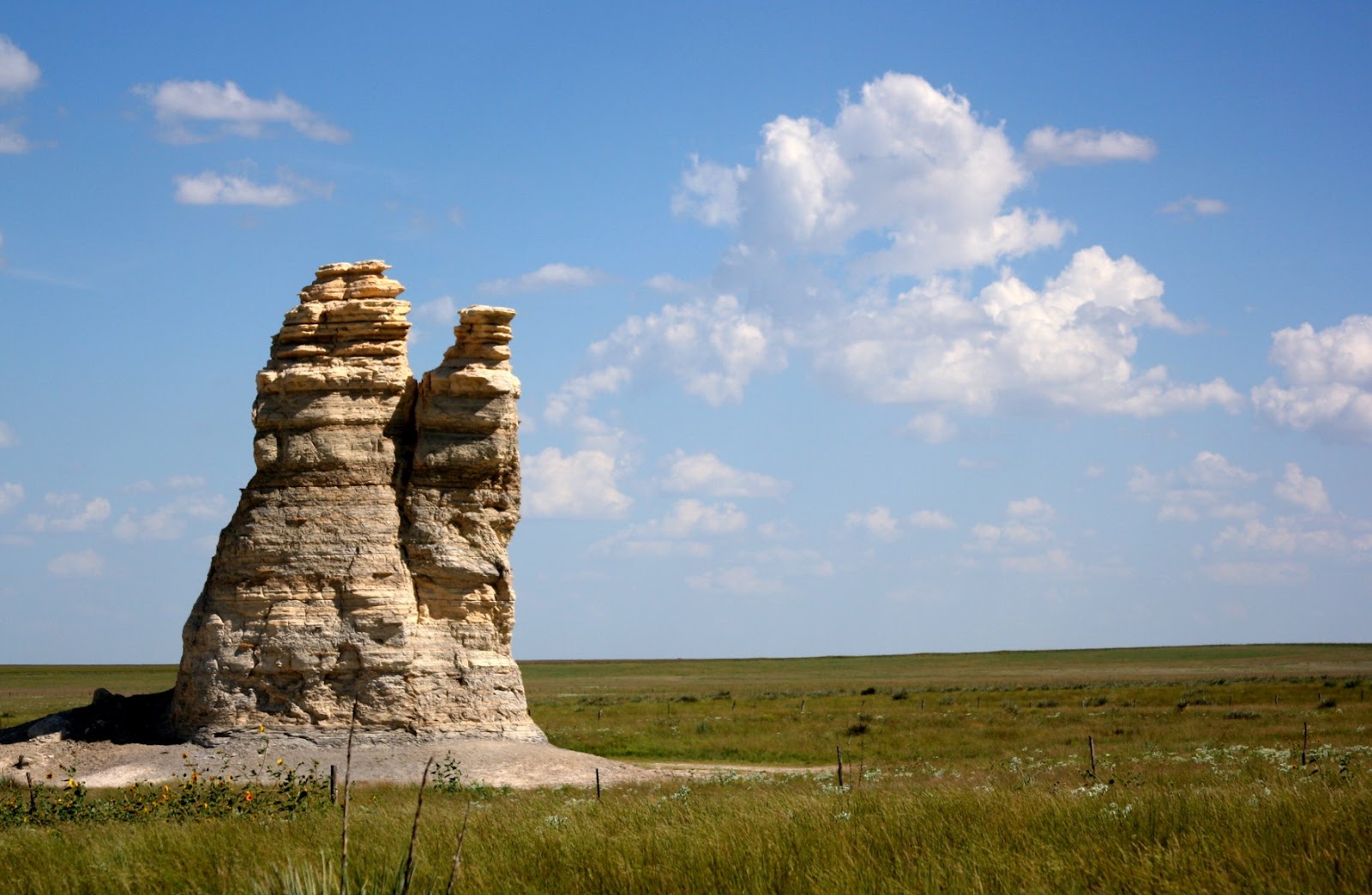
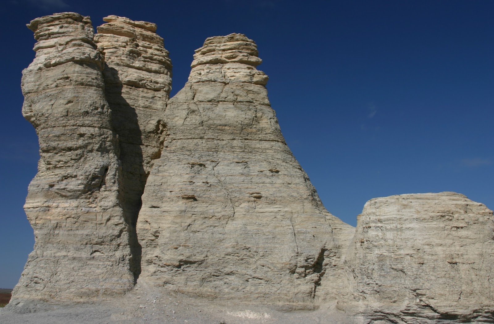
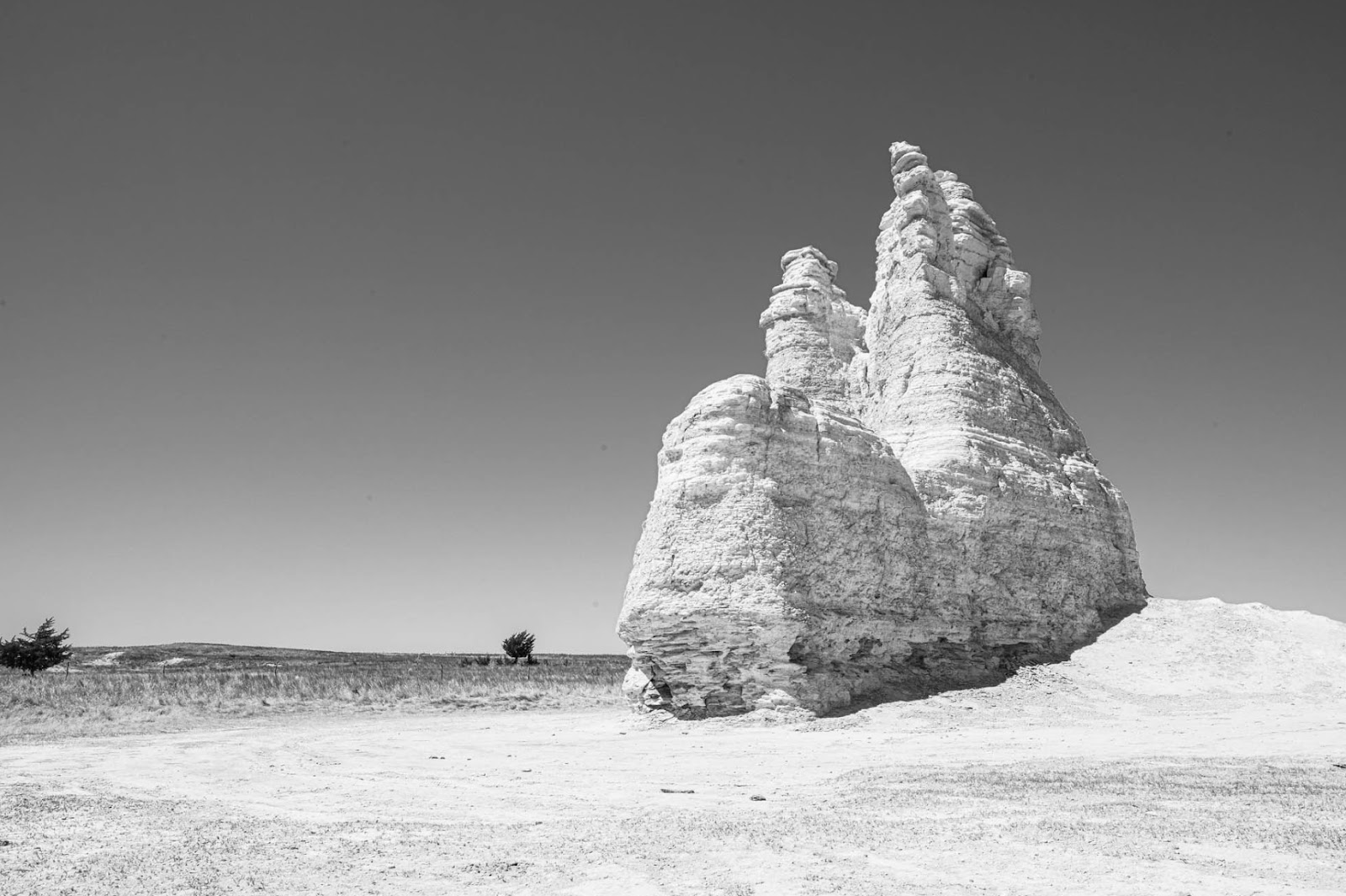
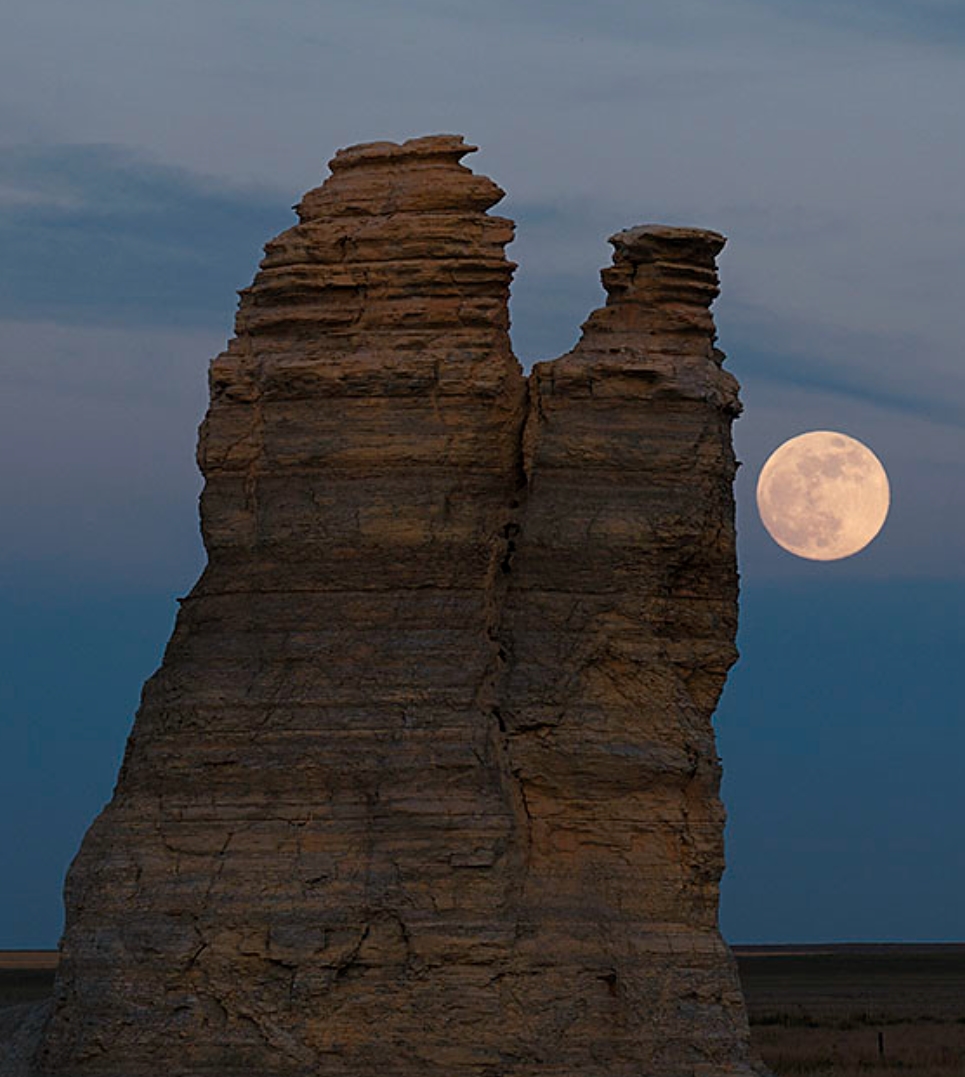
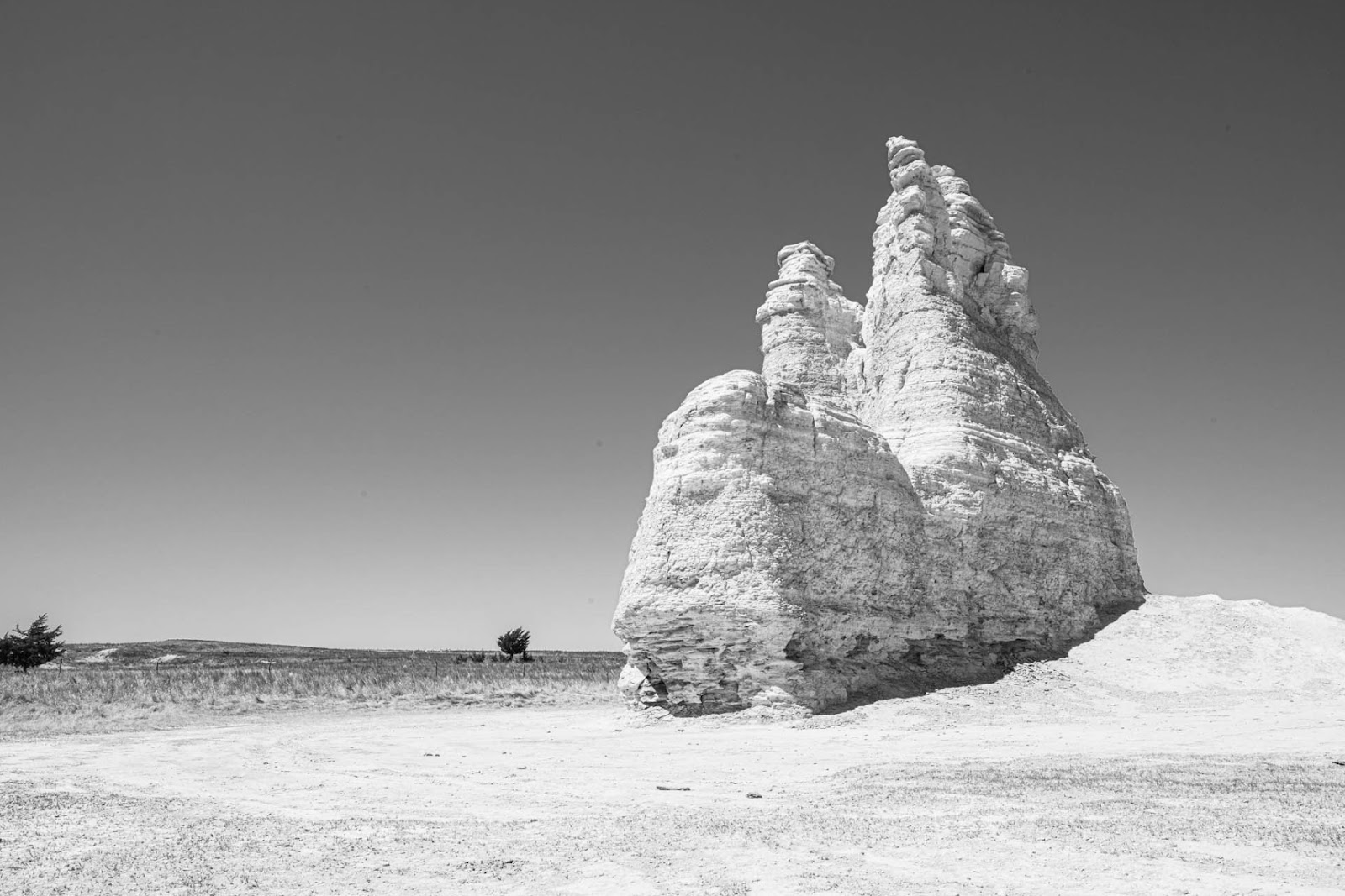
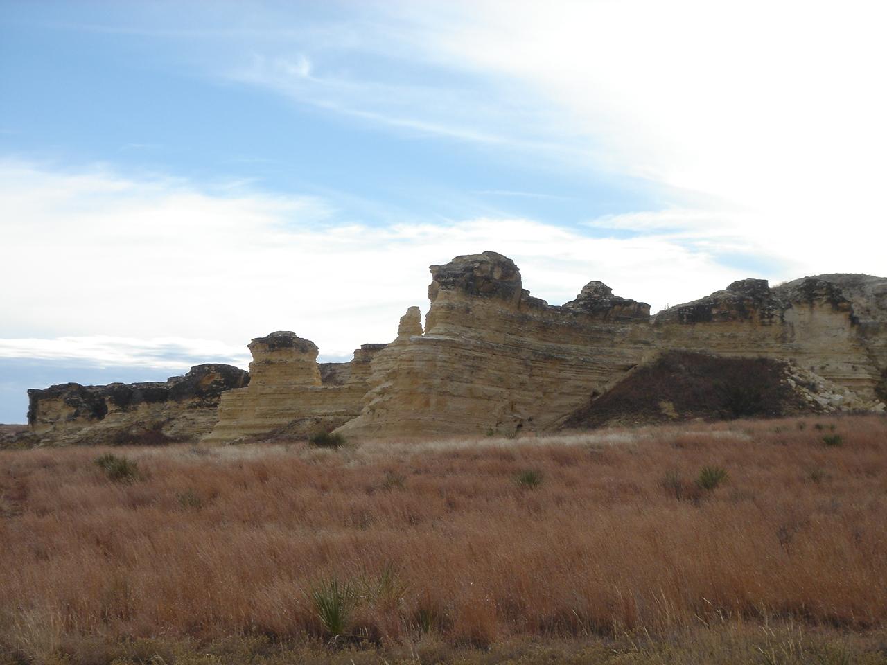
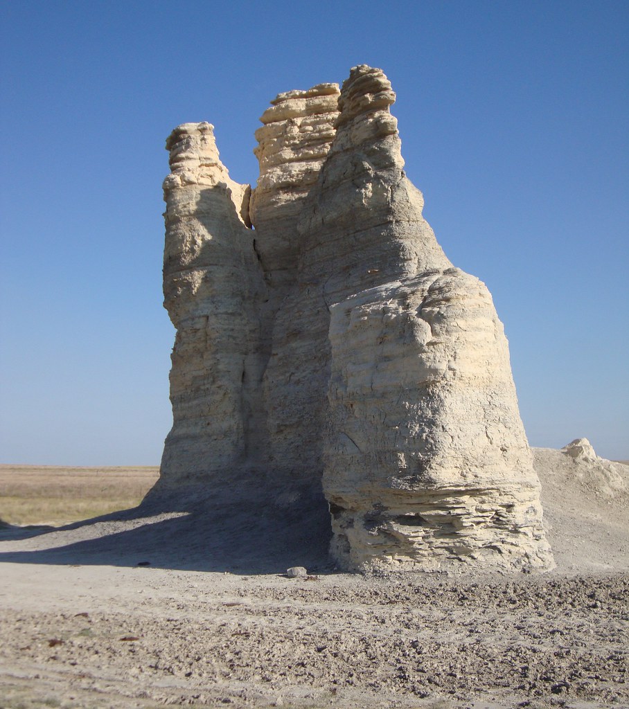
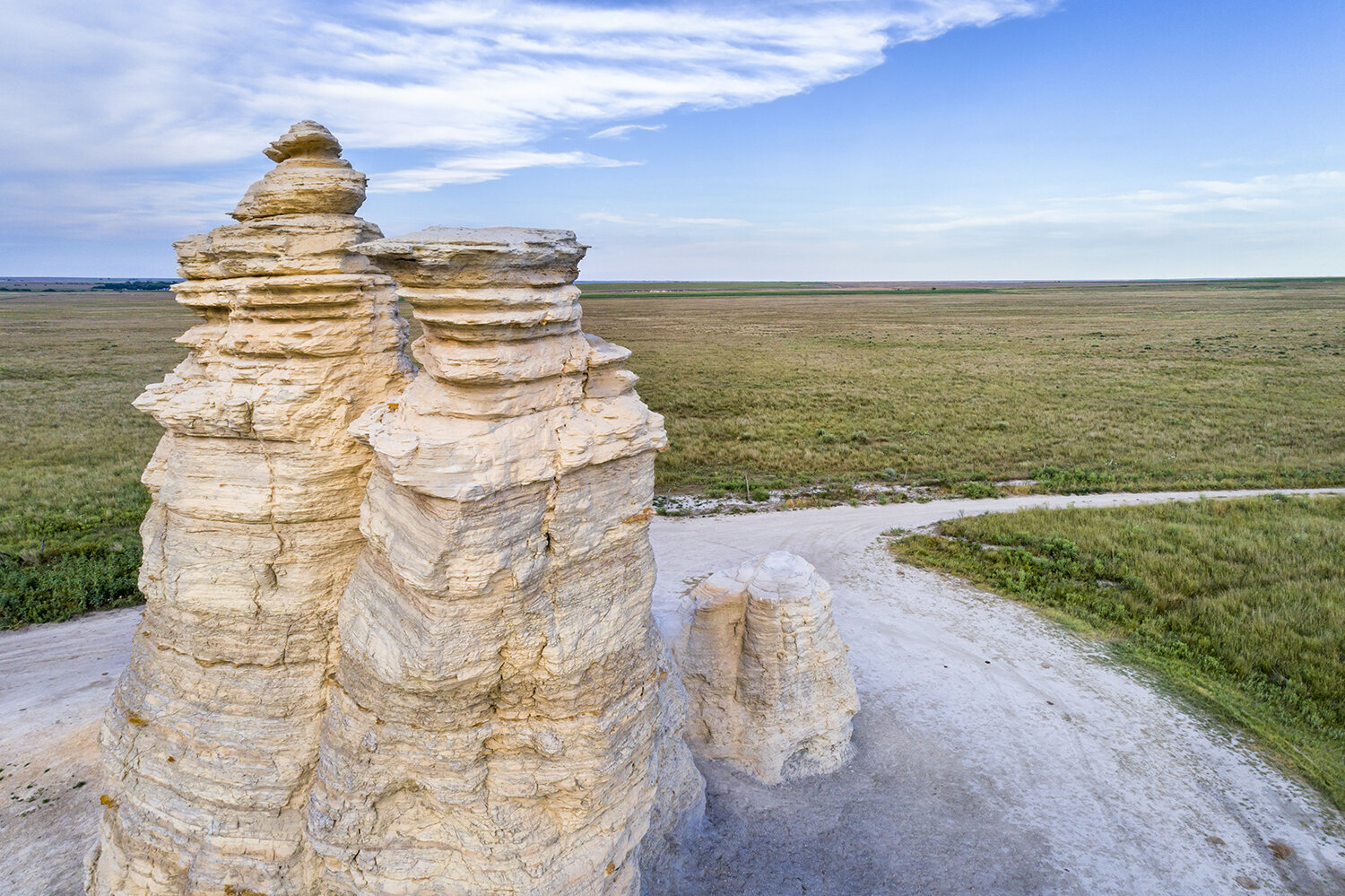
Showing posts with label USA. Show all posts

Thursday 17 August 2023

Sievers Mountain, Colorado

The summit of Sievers Mountain lies in Pitkin County, Colorado, in the United States, at a height of 12,786 feet (3,897 m). Located in the Elk Mountains, which are a subrange of the Rocky Mountains, Sievers Mountain lies 21 miles (34 km) west of the Continental Divide. In the Maroon Bells-Snowmass Wilderness, seven miles southwest of Aspen, White River National Forest manages the mountain. In addition to Willow and Maroon creeks, which are tributaries of the Roaring Fork River, precipitation runoff drains from the mountain slopes. 

As a result of the 4,000-foot rise in elevation within 1.5 miles of Maroon Creek, and the 1,950-foot rise within 1.21km of Willow Creek, there is significant topographic relief present. One of Colorado's most photographed places is Maroon Lake, which was formed when a landslide from Sievers Mountain slid into the valley and dammed West Maroon Creek. The United States Board on Geographic Names has officially adopted the mountain's toponym. 

Its climate is classified as alpine subarctic according to the Köppen climate classification system, which features cold, snowy winters and cool to warm summers. During the early spring, the area receives a dry period due to the altitude, so it receives snow in winter and thunderstorms in summer. Late July and August are the peak months for the seasonal monsoon, which brings afternoon rain, hail, and lightning.

Read More - The Canadian Mount John Laurie


Thursday 25 May 2023

Steens Mountain, Oregon United States

In the heart of Oregon lies Steens Mountain, a natural wonder. By providing in-depth information about the mountain's awe-inspiring beauty, rich biodiversity, and recreational opportunities, we aim to become your trusted source of mountain information. Get ready to discover Steens Mountain's secrets as we embark on a virtual journey. Nature's enduring beauty and the importance of preserving our natural heritage are exemplified by Steens Mountain. All who venture into its embrace are captivated by its majestic peaks and rich biodiversity. Experience the wonders of Steens Mountain's untamed landscapes on your own adventure. Make sure to tread lightly, leaving only footprints and taking with you memories you'll never forget.

The Wonders of Geology

A fault-block mountain with an impressive elevation of 9,733 feet (2,967 meters), Steens Mountain is an impressive example of geological grandeur. Visitors are captivated by the breathtaking views and the region's complex tectonic history.

Plants and animals that are unique

Nature enthusiasts and wildlife photographers alike are captivated by Steens Mountain's diverse flora and fauna. Its diverse ecosystems support a wide array of plant species, from alpine meadows adorned with vibrant wildflowers to ancient juniper trees.

It's not uncommon for birdwatchers to see raptors soaring through the skies, including the majestic golden eagle and the elusive prairie falcon. There are also bighorn sheep, pronghorn antelope, and mule deer roaming the rugged terrain.

The wilderness area of Steens Mountain

There is a protected area surrounding Steens Mountain and its surrounding landscapes, called Steens Mountain Wilderness. A pristine wilderness that spans over 170,000 acres (68,800 hectares) and protects the mountain's delicate ecosystems was designated as a national park by the United States Congress in 2000.

An extensive network of trails caters to all levels of adventurers within the wilderness area. Whatever your hiking style, Steens Mountain's trails offer something for everyone, from avid hikers to leisurely strollers enjoying the tranquility.

Recreation in the outdoors

There are a variety of recreational opportunities available throughout the year at Steens Mountain, which is a haven for outdoor enthusiasts. Take a look at some of the activities that attract tourists:

Backpacking and hiking

As a result of its rugged beauty and diverse landscape, Steens Mountain is a popular destination for hikers and backpackers. Those looking for day hikes or multi-day adventures will find trails in the region that cater to their needs. Observe cascading waterfalls and discover hidden alpine lakes as you traverse the mountain's ridges.

Viewing and photographing wildlife

Steens Mountain presents numerous opportunities for wildlife observation and photography for those who are passionate about wildlife. Witness the majestic beauty of bighorn sheep scaling rocky cliffs or pronghorn antelope gracefully grazing the plains. Be respectful of the animal's natural habitat and behavior by maintaining a respectful distance.

Stargazing and camping

Spend a night under the starlit sky on Steens Mountain to experience the serenity of the mountain. You can immerse yourself in nature's sounds and sights at several campgrounds, which provide basic amenities. Experience the wonder of the night sky as darkness falls and gaze up at the heavens.

Steens Mountain's preservation

Efforts to conserve

Steens Mountain must be protected and preserved. The mountain's ecosystems and cultural heritage are preserved for future generations by a number of organizations, governmental bodies, and local communities.

Practices for sustainable tourism

The adoption of sustainable tourism practices is essential when exploring Steens Mountain as a responsible visitor. To help minimize our impact, here are a few tips:

  1. Plants need to be protected, so stay on designated trails.
  2. Leave no trace of your visit by disposing of waste properly.
  3. Keep a safe distance from wildlife when observing it.
  4. Contribute to the economy of the region by supporting local businesses.

Read More  - The Spectacular Rimrock Trail


Saturday 13 May 2023

Mount Katahdin: The Centerpiece of Baxter State Park

Are you an avid hiker who enjoys a challenge and wants to take on one of the toughest hikes in the United States? Then look no further than Mount Katahdin in Maine. Rising more than a mile high, this iconic peak is the centerpiece of Baxter State Park, which offers a range of hiking trails, camping options, and scenic vistas for outdoor enthusiasts of all skill levels.👌 

Mount Katahdin is located in Baxter State Park, in the heart of Maine. It is the highest peak in the state and the northern terminus of the Appalachian Trail. The mountain is part of the rugged and remote Maine wilderness, which means hikers should be prepared for unpredictable weather and challenging terrain.

The climate on Mount Katahdin is cool and damp, with average temperatures ranging from the low 30s in winter to the mid-60s in summer. Rainfall is common throughout the year, and snow is common in the winter months. Hikers should be prepared for sudden changes in weather, including high winds, heavy rain, and even lightning strikes.

Mount Katahdin offers a range of hiking trails, each with its own unique challenges and rewards. The most popular route to the summit is the Hunt Trail, which covers approximately 5.2 miles and involves a vertical climb of more than 4,000 feet. This trail is recommended for experienced hikers only, as it involves scrambling over boulders and steep inclines.

Other popular trails on Mount Katahdin include the Abol Trail, which offers stunning views of the surrounding forests and lakes, and the Knife Edge Trail, which is considered one of the most challenging and dangerous hikes in the United States. This narrow ridge runs along the summit of Mount Katahdin, with steep drop-offs on either side. Hikers attempting this trail should be experienced and prepared for exposure to high winds and changing weather conditions.

Baxter State Park offers a range of camping options for hikers, including backcountry camping and designated campsites. Backcountry camping requires a permit and is only allowed in certain areas of the park. Designated campsites offer more amenities, including picnic tables, fire rings, and nearby water sources. However, these campsites can fill up quickly, especially during peak hiking season in the summer months.

Hiking on Mount Katahdin can be dangerous, especially for inexperienced hikers who are not familiar with the terrain and weather patterns. In addition to the Knife Edge Trail, there are other areas of the mountain that are steep and rocky, with potential hazards such as loose rocks and unstable footing.

To stay safe while hiking on Mount Katahdin, hikers should be prepared for changing weather conditions, bring appropriate gear such as sturdy hiking boots and rain gear, and carry plenty of water and snacks. Hikers should also avoid hiking alone and tell someone their itinerary and expected return time. In the event of an emergency, hikers should carry a map, compass, and whistle, and know how to use them.

Therefore, Mount Katahdin is a must-visit destination for hikers and outdoor enthusiasts who are looking for a challenge and want to experience some of the most beautiful scenery in the United States. However, hikers should be prepared for changing weather conditions, steep and rocky terrain, and potential hazards such as loose rocks and unstable footing.✌😗😃: 


Friday 3 February 2023

Kīlauea - An active shield volcano in the Hawaiian Islands

 Kīlauea is an active shield volcano located on the Big Island of Hawaii. It is one of the most active and well-known volcanoes in the world and has been continuously erupting since 1983.

Kīlauea is a central feature of Hawaii Volcanoes National Park, which attracts millions of visitors every year to see its stunning landscape, including the massive caldera, which is a crater formed by volcanic activity, and the towering plume of smoke and ash that rises from the summit.

The eruption of Kīlauea has had a significant impact on the surrounding landscape, creating new land formations and adding new layers of volcanic rock to the island. The lava flows from Kīlauea have also destroyed homes and communities, and the ash and gas emissions from the volcano have had a significant impact on air quality and visibility.

Despite the challenges posed by the eruption, Kīlauea remains an important part of Hawaiian culture and a major tourist attraction. Visitors to the park can take guided tours of the volcano, hike on the trails through the surrounding wilderness, or attend a ranger-led program to learn more about the geology and history of the region.

Overall, Kīlauea is a unique and fascinating destination that provides a window into the powerful forces of nature and the rich cultural history of Hawaii. Whether you're an avid hiker, a science enthusiast, or simply looking for an awe-inspiring experience, Kīlauea is a must-visit destination.


Monday 21 November 2022

FOSSIL BUTTE NATIONAL MONUMENT

Standing at the base of Fossil Butte, gazing up 1,000 feet at the rust- and ocher-stained cliffs, with the crackling desert wind rattling sage and tumbleweeds, you’d never guess that eons ago you’d have been looking up from the bottom of a subtropical ocean. Some 50 million years ago, during the Eocene Epoch, millions of fish wriggled across what’s now the sky. With the ebb and flow of millennia, they sifted into the mud and fossilized. Today, visitors join paleontologists during the summer to dig for the ancient remains of fish, insects, turtles, birds, and even bats. 

You can also hike (be watchful for rattlesnakes) on two short trails—the 1.5-mile Fossil Lake Trail and the 2.5-mile Quarry Trail. This is also a prime wildlife-viewing area, where you’re likely to see pronghorn, mule deer, white-tailed prairie dogs, and ground squirrels, and you might be lucky enough to spot moose, elk, and beaver as well. A variety of birds are also seen here, including Canada geese, great blue herons, Clark’s nutcrackers, yellow-headed blackbirds, great horned owls, and red-tailed hawks.


Wednesday 19 October 2022

Hurricane Ridge Olympic National Park

The vista from Hurricane Ridge, on clear days, is a breathtaking one, with peaks and deep valleys crowding the panorama. The Olympic Mountain range isn’t tall, by most standards, topping off just under 8,000 feet, but the uneven terrain makes the center of the mountain clump hard to access. This area comes by its name honestly—winds in the exposed meadow near its visitors center top 75 miles per hour, sculpting the snow in the winter and blowing off ball caps in the summer. Numerous trails are accessible from here. 
The Hurricane Ridge area is located 17 miles south of Port Angeles on Hurricane Ridge Road. From U.S. 101 in downtown Port Angeles, turn south (away from the water) onto Race Street, which becomes Hurricane Ridge Road. The mountain road is plowed with snow on winter weekends. 
The Hurricane Ridge Visitor Center (360/565-3130, www.nps.gov/olym, open year-round, hours vary seasonally) houses exhibits (including a 20-minute orientation film) and a limited snack bar, and a gift shop on the lowest level. But the real draw is outdoors, where wildflowers bloom in the alpine meadows in the summer. In their signature wide-brimmed hats, park rangers—part police force, part naturalists, part tour guides—give guided walks and talks about the area. 
Views of the area get even better from the top of Hurricane Hill, a peak more than 5,700 feet high. From here you can see the broad Strait of Juan de Fuca and the full spread of the Olympic peaks. The entire route is paved, but only the first section is wheelchair accessible. 


Saturday 6 August 2022

Oak Creek Canyon – The Smaller Cousin of the Grand Canyon

Oak Creek Canyon is often referred to as a smaller cousin of the Grand Canyon. A river gorge located just south of Flagstaff, Highway 89A weaves a charming route through Oak Creek Canyon on its way to Sedona and Flagstaff. Oak Creek Canyon area is situated in a Transition Zone between two great geologic provinces: the Colorado Plateau and the Basin and Range.

The canyon has magical scenic scenes, dense woods shadow the road, and the steep cliffs are colored in bands of red and yellow sandstone, pale limestone, and black basalt. Oak Creek Canyon is a popular summer vacation area with many day-hiking trails, such as the East Pocket Trail, a steep, wooded climb to the canyon rim.

One of the prettiest and easiest hikes in Oak Creek is along the three-mile (five-kilometer) West Fork Trail, which follows a stream past abandoned apple orchards and into a narrow red rock canyon. At nearby Slide Rock State Park, swimmers enjoy sliding over the rocks that form a natural water chute. This canyon is approximately 19 kilometers long ranging in width from 0.8 to 2.5 miles, along with 250 to 610 meters in depth.

Oak Creek, a tributary of the Verde River, flows along the bottom of the canyon and is one of the few perpetual streams in the high desert region of northern Arizona. Oak Creek is mainly responsible for carving the modern Oak Creek Canyon, through movement along the Oak Creek Fault, a 48 kilometers long north-south normal fault line, is thought to have played a role as well. Sedona-Oak Creek Canyon area offers some of the most unique and spectacular geologic features in northern Arizona.

Because of the relatively sparse vegetation, most of these features are easy to recognize and photograph. Some of these geologic features are common on the Colorado Plateau of northern Arizona, western Colorado, southern Utah, and northeastern New Mexico. Others occur in many other parts of the American Southwest.

Oak Creek Canyon slices through the Mogollon Escarpment to the House Mountain shield volcano rising from the floor of Verde Valley. teau and the Basin and Range (Figure B.) The Colorado Plateau, a 130,000-square-mile region of vast plains, high mesas, buttes, deep canyons, volcanic fields, and isolated mountain clusters, is built of thousands of feet of generally horizontal sandstone, shale, limestone strata, and basalt flows.

In north-central Arizona, the southern margin of the Colorado Plateau is the Mogollon Rim, that line of spectacular cliffs north of Sedona. The sedimentary and volcanic rock layers that form this part of the Colorado Plateau are beautifully exposed in the Mogollon Rim north of Sedona. In ascending order they are the Supai Group, the Coconino Sandstone, the Toroweap, and Kaibab Formations, and the basalts of the San Francisco volcanic field. Basalts of the Mormon Mountain volcanic field cap the Mogollon Rim to the west of Sedona.

South of Sedona, are dark-colored basalts of the House Mountain volcano and the white sedimentary layers of the Verde Formation. For most of its geologic history, this part of Arizona was a low-lying region where sediment was deposited and preserved to form the layers of red and buff rocks exposed in the SedonaOak Creek Canyon region.

The oldest of these sedimentary rock units that are exposed throughout the region is the Supai Group, deposited 310 to 270 million years ago (some sources say that the Supai Formation is 270-220 million years old). During this time the Sedona-Oak Creek Canyon region was a nearly flat, subtropical desert coastal plain bordered by shallow seas, at the latitude of present-day Central America. Some sandstones. and conglomerates were deposited by wet-weather streams. Other sandstones were deltas, beaches, or desert dunes. Mudstones and limestones accumulated in lagoons and the sea.

The sea advanced and retreated across this coastal plain numerous times, leaving alternating layers of terrestrial and marine sedimentary rocks. Arid conditions limited life on land and fossils are mainly from species that lived in the sea. The upper part of the Supai Group was deposited 275 to 270 million years ago (Permian time) as extensive sand seas on an arid coastal plain. At times the dune sand was reworked by the tides and spread along beaches, as occurs in coastal portions of the Sahara and Namib Deserts today.

These massive wind-deposited sandstones, well-cemented by calcium carbonate and silica, are resistant to erosion and form most of the orange-red cliffs and buttes around Sedona, such as Bell Rock, Courthouse Rock, Coffee Pot Rock, and Cathedral Rock. The Coconino Sandstone (270 to 265 million years old, late Permian time) forms the tall, nearly vertical cream-colored cliffs above the Supai Group.

Deposited as massive sand dunes, similar to those found in the great sand seas of the Sahara and Saudi Arabia, this sandstone represents an arid, inland environment far removed from the sea. The Coconino Sandstone and the underlying upper Supai Group contain very few fossils due to harsh desert conditions. The Toroweap Formation (about 265 to 262 million years old, late Permian time) caps the Coconino Sandstone and represents a return to an arid, coastal environment.

This thick sandstone was once beach and shallow coastal sand. It contains beds of gypsum that accumulated as high temperatures evaporated seawater from saturated desert soils. Distinctive buff-colored cliffs above the Toroweap Formation mark the Kaibab Formation (about 262 to 255 million years ago, late Permian time). This rock unit consists of silty limestone and dolostone, and sandstone and siltstone cemented by calcium carbonate.

The Kaibab Formation was deposited in shallow seas and on an arid coastal plain. Dark-colored rim rock capping the plateau is basalt from the San Francisco Volcanic Field (Figure B, SF). Beginning about 6 million years ago, magma (molten rock) from deep inside the Earth migrated upward along old fractures and flowed onto the plateau surface as lava. Eruptions continued during the period 3 million to 1000 years ago.

The basalt at Oak Creek Vista is about 6 million years old. The basalt capping the cliffs to the east and southeast of Sedona are old lava flows from the older (3 million to 15 million years ago) Mormon Mountain Volcanic Field (Figure B, MM). The contact between these plateau-capping volcanic rocks and the underlying Kaibab Formation marks a time gap in the geologic record of nearly 240 million years, years not represented by the rock at this locality.

The uplift of the Mogollon Highlands in central Arizona about 60 million years ago tilted the entire sequence of Paleozoic and Mesozoic strata in the Sedona-Oak Creek Canyon region to the north. At this time, rivers flowed from the higher Mogollon Highlands across the Sedona-Oak Creek Canyon region toward the lowlands to the north. Erosion by these rivers removed the Mesozoic strata that once existed here and left deposits of sand and pebbles collectively called “rim gravels’ because they are found along the Mogollon Rim.

Between 35 and 15 million years ago, the crustal rocks of western North America were stretched, thinned, and broken in blocks along steep cracks, called faults. This crustal extension led to the collapse of the Mogollon Highlands. This collapse, combined with thousands of feet of uplift of the Colorado Plateau, triggered a drainage reversal in the Sedona-Oak Creek Canyon region. Streams now flowed southward from the southern rim of the Colorado Plateau and the Oak Creek and Verde River system slowly developed.

Today, continued erosion is wearing back the cliffs of Pennsylvanian, Permian. and Neogene rocks north of Sedona. This northward retreating line of cliffs, the Mogollon Rim, is the southern edge of the Colorado Plateau in Arizona. Continued stretching of the crust in the Sedona-Oak Creek Canyon region caused one of these blocks to subside thousands of feet relative to other blocks, forming the deep basin now occupied by the Verde River.

A high-standing block was eroded to form Mingus Mountain southeast of the Verde Valley. About 10 million years ago molten rock (called magma inside the earth and lava when it erupts onto the surface) migrated upward along faults and flowed onto the land surface. A series of these lava flows south of present-day Sedona built the House Mountain shield volcano. During this same time period, faulting and lava flow dammed the Verde River. More than 275 feet (900 m) of sediment accumulated as limestones, mudstones, sandstones, gypsum, and conglomerates in these dry-climate lakes and form the Verde Formation that is exposed along the modern Verde River valley.

The early Verde River, lower Oak Creek, and some of their tributaries flowed in looping meanders across broad floodplains, much like the Mississippi River do today. During the last 6 million years regional uplift and reactivation of faults caused these streams to down cut their channels into underlying sediments and, eventually, bedrock. This downcutting preserved the sinuous flow pattern of ancient streams in many canyons of the modern landscape.

Other canyons have straight courses because they were cut by streams eroding the pulverized zones of rock along faults. For example, several episodes of vertical movement along the Oak Creek Fault produced a zone of shattered and powdered rock. Oak Creek excavated this shatter zone as it extended its headwaters into the Mogollon Rim, producing Oak Creek Canyon.

Later movement along this fault triggered outpourings of lava that filled the canyon. The lava cooled to form basalts that were offset as movement along the fault continued. Today, weathering, rock falls and landslides, and erosion by the Verde River-Oak Creek drainages continue to enlarge Oak Creek Canyon and wear back the Mogollon Rim. Red rock mesas and buttes surrounding Sedona are monuments to the power of these processes and record the diverse landscapes that once existed in.


this part of North America.