Showing posts with label Georgia. Show all posts

Friday 7 August 2020

Shag Rocks – South Georgia

The Shag Rocks are six small islands in the westernmost extreme of South Georgia, 240 km west of the main island of South Georgia, and 1,000 km off the Falkland Islands. The Shag Rocks cover a total area of fewer than 49 acres. Situated on the South Georgia Ridge, they have a peak elevation above sea level 246 ft and stand in water approximately 1,047 ft deep. 

The average temperatures fall between −1.2 °C to 10 °C and rarely climbing above 15 °C. There is no considerable vegetation, but most of the rocks are covered by the guano of seabirds. The major wildlife found on the islands is the South Georgia shags, prions, and wandering albatrosses.

Shag Rocks has been the site of several shipwrecks. The history tells us, that in 1762, Shag Rocks (Islas Aurora) discovered by Jose de la Llana with the Spanish Ship Aurora. The famous Aurora Islands are being named after to this ship. Moreover, they were visited frequently with the Spanish ship San Miguel in 1769, again by the Aurora in 1774, and in 1779 by the Princesa and the Dolores. The Auroras were finally mapped by the Spanish corvette Atrevida in 1794.

Though, the Aurora Islands are considered by many legends to have been a mistaken sighting that was coincidentally near the Shag Rocks, which were recognized to sealers prior to 1823. Later on, they were later rediscovered by James P. Sheffield and given their present name, most likely because shags and other seabirds frequent them.

They were charted by Discovery Investigations staff on the William Scoresby in 1927. The first known landing on the islands was made by Argentine geologist Mario Giovinetto was lowered from a helicopter to collect rock samples in 1956. The Shag Rocks form part of the British overseas territory of South Georgia and the South Sandwich Islands. Prior to 1985, they came within the Falkland Islands Dependencies. However, the Shag Rocks and Black Rock are laying claims by Argentina.

Black Rock and Shag Rocks are on the route from the Falkland Islands to South Georgia Island, on a seamount of Scotia Ridge. In 1985, United Kingdom formed its overseas territory of South Georgia and the South Sandwich Islands, which includes Shag Rocks and Black Rock. Thus, it is now assumed accountability for preservation and defense of the area.

Product You May Interested
Crush Food Cravings with Odd Water Hack and Melt 62lbs
Flavor Pairing Ritual Supercharges Women’s Metabolisms
Unlock your Hip Flexors, Gives you More Strength, Better Health, and All-Day Energy.
60 Seconds of Habit! That Reversed Type 2 Diabetes and Melted 56 lbs of Fat
Boost Your Energy, Immune System, Sexual Function, Strength & Athletic Performance
Longest Living Doctors Unlocks Fastest Way to Burn Fat
Perfect Paleo Powder – The Easiest Way You Can Get the Protein & Critical Nutrients Your Body Needs
Lose weight, burn fat, boost metabolism and immunity, Fight inflammation & Increase your energy with this one ridiculously simple thing.
The Industry’s First Metabolism Fueling System That Heightens Thermogenesis Even While You Sleep.

Friday 28 September 2018

Providence Canyon, Georgia

 
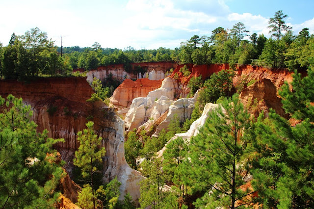
Providence Canyon is about 150 miles southwest of Atlanta, in the US state of Georgia. This is a network of gorges and huge gullies lovingly called Georgia's “Little Grand Canyon.” Providence Canyon is considered to be one of Georgia’s “Seven Natural Wonders”. Providence Canyon is a perfect example of a testament to the power of man’s influence on the land. Surprisingly it isn’t at all natural. Many Georgians aren't aware of Providence Canyon It's situated in an outdoor recreation area that encompasses 1,103 acres and 16 canyons. These imposing canyons were formed not by the action of a river, erosion of more than millions. It is of years by rainwater runoff from farm fields in less than a century. The canyon exquisitely-hued sediment walls are a product of inexperienced farmers making a colossal mess of things, and Mother Nature just kind of worked with it from there.
 
Providence Canyon started creating in the start of 18th century due to poor farming practices. That prevailed across the nation and especially in the south. In those days, land and agriculture was very cheap, infinite and seemingly expendable giving way to a combination of plantations. A small farms sooner or later a sharecropper system that not only degraded the land. Hence it also kept farmers in debt and uneducated. Native forest cover was cleared so the land could be farmed. No measures were taken to avoid soil erosion leading to huge loss of topsoil. Therefore, small gullies started to form and speedily grew deeper and more extensive, until they were three to five feet deep by the 1850s. These small channels started to further focus runoff increasing the rate of erosion. Nowadays, some of the gullies at Providence Canyon are about 150 feet deep.
 
In spite of its current formation, Providence Canyon is a treasure trove for geologists and visitors. Because, over the times passes, erosion has exposed the geologic record of many million years within its walls.  The minerals have stained the sediments, making a wide range of colors. The Canyons are lies in a region that was formed by deposition of marine sediments between somewhere 60 to 74 million years ago. Moreover, the soil in the top part of the canyon wall was deposited about 65 million years ago. It was just after the age of the dinosaurs. It’s fairly coarse sand is a reddish color caused by the presence of iron oxide.
 
Providence Canyon continues to erode, however, the floor of the canyon is more resistant and growth of pine trees, buses and other vegetation has helped stabilize the soil. Underneath this formation lies what is acknowledged as the Providence Sand. It makes up most of the canyon walls. It is 119 feet thick and was deposited about 72 million years ago. The upper part of this layer is very fine sand mixed with white clay. Thus, the middle layer is coarse and more intriguing, with beds of yellow (limonite) and purple (manganese) deposits. The lowest and oldest layer is black and yellow mica-rich clay. In addition to sightseeing and taking photographs, Georgia's Little Grand Canyon offers the many activities, i.e. hiking, camping, stargazing, picnic, and geological. 
 
The bottom of the Providence Canyon floor was deposited about 75 million years ago. Its orange color is poorly exposed and overgrown by vegetation. Visitors are advised to enjoy views of canyons from the rim trail, but need to stay behind fences and off the fragile canyon edge. Providence Canyon has a few other eccentricities that make it stand out from your standard canyon hike. Hiker’s likes to explore the deepest canyons will usually find a thin layer of water along the trail, indication of the water table below. There is a playground, picnic tables and overnight campgrounds available, with several trails of varying difficulty.