Showing posts with label Lebanon. Show all posts

Tuesday, 28 March 2017

Jeita Grotto, Wonderful Underground Caves in Lebanon


Jeita Grotto is actually a cave system stretches about 9 kilometers into the mountains 18km northeast of Beirut. Jeita Grotto is one of greatest natural wonders, discovered in 1836 by Reverend William Thomson; and opened as a tourist attraction in 1969. During civil war, the caves were used as an ammunition store, now interconnected, karstic limestone caves are situated in the Nahr al-Kalb valley within the locality of Jeita. Though inhabited in prehistoric times, the lower cave was not rediscovered until 1836 it can only be visited by boat since it channels an underground river that provides fresh drinking water to more than a million Lebanese. These lower caves are always explored by small boat and are closed when the flood levels rise too high. However, the extraordinary upper cavern stays open all year and is explored on foot or via a cable car. It has strategically positioned colored lights that showcase the stalactites and stalagmites in all their crystalline glory. Moreover, the upper galleries house the world's largest known stalactites are composed of a series of chambers the largest of which peaks at a height of 390 feet.


The Lebanese speleologists discovered the upper galleries 60 metres above the lower cave in 1958. This has been accommodated with an access tunnel and a series of walkways to enable tourist’s safe access without disturbing the natural landscape. In spite of all kinds of tatty side attractions the site remains a spectacular day trip from Beirut, but keeps in mind that there’s no photography allowed. Geita Grotto is Lebanese national symbol and most famous tourist spot, plays an imperative role in social, economic and cultural player in the country. Geita Grotto was one of top 14 finalists in the New 7 Wonders of Nature competition.

 The Jeita caves are solutional karst caves, formed more than millions of years due to the dissolution of limestone, dissolved by carbonic acid charged rain water and groundwater. Thus, when the limestone, were originally waterproof, contains cracks produced by tectonic forces the water oozes into the rock and starts to widen the cracks and solute caves inside the layers Jeita is the longest cave complex in the Middle East geologically, the caves provide a tunnel or escape route for the underground river, which is the principal source of Nahr al-Kalb.

The Jeita grotto is the longest explored cave in Lebanon, hosts approximately 280,000 visitors per year. Moreover, the Jeita cave emits a spring with a flow ranging from 1–2 m3/s, providing fresh drinking water for one-and-a-half million inhabitants of the capital, Beirut. However, water pollution, due to domestic and agricultural runoff, remains a serious concern as recent analysis detected an increasing presence of coliform bacteria.

The name of the cave changed many times since its discovery. Initially it is called as Grottoes of Nahr al-Kalb, also known as Djaita, Jehita, and finally Jeita meaning “roaring water”. Nahr al-Kalb is the name of the river that runs through the grottoes. The Jeita grotto contains a lot of touristic attractions that fill the visitor’s time with enjoyment and happiness. The main attractions include ropeways, train, miniature zoo, gardens and many sculptures.


Wednesday, 20 August 2014

Baatara Gorge Waterfall Lebanon

When Nature displays its manifold wonders in most unbelievable formations throughout on the earth planet. The Lebanon’s Baatara Gorge Waterfall has a unique formation which re-establishes this widely famous truth once again. This scarce waterfall visible during the ice melting months of March and April is actually located in the Balaa village which falls in between the Lebanese cities called Laqlouq and Tannourine. The location of the Baatara Gorge Waterfall is generally popular amongst the local people as the “Three Bridge Chasm”.

In 1952, Baatara Gorge waterfall was first made public by Henri Coffiat, who was a bio-speleologist by profession. He reported the existence of this exotic waterfall which is 255 meters high. Moreover; when the summer seasons beings in, the ice of the Mount Lebanon starts melting. The waterfall location is made all the more remarkable because of the three naturally formed bridges which hang one on top of the other which move inside in to the chasm of Mount Lebanon. 

The Baatara Gorge Waterfall cascades down from three bridges. The hole is famous to be made limestone belonging to the Jurassic age. The stunning waterfall is a great tourist attraction in Lebanon. It is claimed that age of the limestone is identified to be approximately 160 million years. 

Some researchers have also performed dye experiments on the water of the Baatara Gorge Waterfall only in order to show that the water once again come out under sun in another village called Mgharet al-Ghaouaghir which is situated near to the village of Balaa. There was also a suggestion to fix safety equipment’s for folks interested in sports who accessed the region. Though, this suggestion was soon nullified by the authorities as that would ruin the natural beauty of the place.

The geologists say about the creations of this stunning landform, it is understood that the top most bridge of the gorge may have had the earliest presence. Maybe it was following a number of erosions and collapses that the other two bridges may have got formed. The Gorge of the Baatara Gorge Waterfall is still acknowledged to be constant changing because the severity of the winter ice several a times leads to breaking of huge chunks of the pothole from both sides of the wall. 

There’re number of warnings issued to visitors nearing the pothole, and these warnings are there to prevent them from going near to the mouth as it may be slippery and also warn them to access the bridges, because they always bear the risk of collapsing under the body weight of numerous travelers together. Else, the Baatara Gorge Waterfall is a charming destination for adventurous tourists who can also relish the nearby Tannourine Cedar Forest Reserve or the mountain trail of Mount Lebanon. Moreover; there’re camping sites in the region too which can enhance the experience.

Friday, 13 December 2013

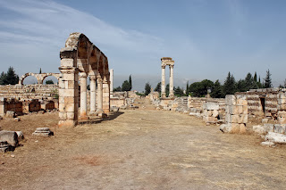
Anjar The Runis City of Lebanon

Anjar is also called as Haoush Mousa is a town of Lebanon located in the Bekaa Valley. The population is 2,400, consisting almost entirely of Armenians. The total area is about 20 S.KM. In the summer, the population swells to 3,500.
Anjar is an outstanding example of Umayyad urbanism and stands unique as the only historic example of an inland commercial centre. The city of Anjar was discovered by Caliph Walid Ibn Abd Al-Malak at the start of the 8th century in between 705-715. The ruins expose a very regular layout, reminiscent of the palace-cities of ancient times, and an exclusive testimony to city planning under the Umayyads. The city of Anjar bears outstanding witness to the Umayyad civilization, i.e an example of an inland commercial centre, at the crossroads of two major routes, one is leading from Beirut to Damascus . While the other crossing (Bekka) leading from Homs to Tiberiade.
This ancient city was unearthed by archaeologists at end of 1940’s. During excavations, the city founded a fortified by surrounded of walls and flanked by forty towers a rectangular area of size about 385 x 350 m. Well dominated by gates flanked by porticos, an important North-South axis and a lesser East-West axis, superposed over the main collectors for sewers, divide the city into four equal quadrants.  Private and public buildings are laid out to a strict plan. The Mosque in the South East Quarter and palace of Caliph occupies the highest part of the site. The small Harems and baths are situated in the North-East Quarter to facilitate the functioning and evacuation of waste waters.
The ruins are dominated by stunning vestiges of a monumental tetrapyle, by the walls and colonnades of the Umayyad palace, three levels of which have been preserved. The structures fit in decorative or architectonical elements of the Roman era, but are also noteworthy for the exceptional plasticity of the contemporary decor within the construction. Anjar was never completed enjoying only a brief existence. The son (Ibrahim) of Caliph Walid was defeated and city was partially destroyed, and constitutes a unique example of 8th century town built at the start of Islamic period. It reflects this transition from a protobyzantine culture to the development of Islamic art and this through the evolution of construction techniques and architectonical and decorative elements that may be viewed in the different monuments.
Anjar surrounding walls incorporate all the features of town planning and the monuments that characterize the Umayyad city. A number of features exist on the outskirts of the complex, like caravanserai, and these must be protected by a buffer zone which would also protect the visual integrity of the Bekaa Valley and limit the development of modern constructions. Regardless of major restoration and reconstruction works, the different monuments comprising the Umayyad city of Anjar evidently demonstrate their functions and relations, and the general plan of the city can easily be identified. A wider diffusion of excavation results would facilitate a better comprehension of the features.
A city with 600 shops and an overwhelming concern for security must have required a fair number of people. Keeping this in mind, archaeologists looked for remains of an extensive residential area and found it just beyond the tetrastyle to the south-west.