Friday 30 November 2018

The Devil’s Marbles of Karlu Karlu

 
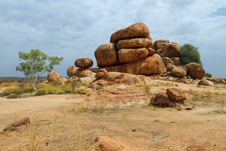
Devil’s Marbles or Karlu Karlu, are a collection of giant granite boulders strewn across a shallow valley. Devil’s Marbles are recognized by the local Warumungu Aboriginals. It is located almost 100 KM south of Tennant Creek in the Northern Territory, Australia. The Devil’s Marble is one of the most widely considered symbols of Australia’s outback.
 
The Marbles have great importance for the Aboriginal people. They’re protected under the Northern Territory Aboriginal Sacred Sites Act. In the Aboriginal mythology the Devils Marbles are the eggs of the rainbow serpent. Many dreamtime stories and traditions of the Warumungu, Kaytetye and Alyawarre Aboriginal folks are linked with this area.
 
The unique shapes are formed by erosion more than millions of years. These marbles are made of granite with varying sizes from 50cm to 6m across. Different boulders are naturally precariously balanced atop one another or on massive rock formation. However, many others have been split cleanly down the middle. Though they are appear to have been prudently placed or maybe brought here by flood or glaciers from distant places. These boulders in fact formed on the ground they stand by erosion of rock that reached the surface from below.
 
The Devils Marbles started out, several million years ago, when an upsurge of molten rock penetrated the ground from below. It spread out and settled into a solid layer within the Earth's crust. Thus, after some time, tectonic forces caused folding of the Earth's crust in the area. Which have lifted the granite causing it to fracture into big, square blocks?
 
The weathering by water and wind rounded off the edges and turned them into smooth boulders that we see today. Moreover the extreme temperature difference between day and night in the arid desert region. Where the reserve is located creates massive stress on these boulders, that causing them to frequently expand and contract. Some of the rocks eventually crack completely in half.
 
According to one interesting story, “Arrange”, the Devil Man, while walking through the area, made a hair-string belt, a type of traditional adornment, worn only by initiated Aboriginal men. He was twirling the hair to make strings. Then he dropped clusters of hair on the ground which turned into the big red boulders. He finally returned to his place of origin, a hill named “Ayleparrarntenhe”, where the legend myths he’s still lives today.


Thursday 29 November 2018

4,000-year-old Termite Mounds Found Equal to the Size of Great Britain


Termites are tiny insects about the size of an ant. They live in colonies that may contain 2 million relatives. Despite their small size they are extraordinary builders.  In the seasonally dry, deciduous forests of northeastern Brazil, obscured by walls of thorny-scrubs, is a vast landscape made up of tens of millions of densely packed earthen mounds. The findings suggest that the over-dispersed spatial mound pattern isn’t generated by aggressive interactions.

The cone-shaped are not nests, actually piles of dirt each measuring 30ft wide at its base and twice as tall as a grown man. Which are waste earths excavated by the termites when they burrow tunnels under the soil. It’s unbelievable that finding an unknown biological wonder of this sheer size and age still existing. There are lots of different kinds of termite mounds. Some of them actually keep the termites cool during the day, and a little bit warmer at night.

Investigators approximation that these are more than 200 million mounds. These are covering a huge region approximately equal to the size of Great Britain. The amount of soil excavated is over 10 cubic KM, comparable to the volume of great pyramids of Giza. The still-inhabited mounds are up to 4,000 years old and so tall they can be seen via satellite.

Therefore, this makes them the largest engineering project by any animal besides humans. Unbelievably, some of these mounds are as old as the Egypt Pyramids themselves. These mounds are remains mainly hidden from view in the deciduous, semiarid, thorny-scrub caatinga forests exclusive to this part of Brazil. The locals call them “murundus” but not too much people outside of the region have heard about it. It was only in recent decades when some of the lands were cleared for pasture that outsiders have come to discover them.

Roy Funch, from the State University of Feira de Santana, first saw these fields of mounds in the 1980s when he arrived in Brazil as a Peace Corps volunteer. A pheromone map might allow the termites to minimize their travel time from any location in the colony to the nearest waste mound.

Investigators have found that this colossal feat of engineering is the work of a tiny species of termite called Syntermes dirus, barely half an inch long. These creatures have been building this landscape for the past four thousand years, and they are still present in the soil surrounding the mounds. Soil samples collected from the centers of 11 mounds and dated youngest mound is about 690 years old, while the oldest was at least 3,820 years old.

These mounds discarded earth, have no internal structures save for a single large central tunnel descending into the ground to meet a widespread network of underground tunnels and thin horizontal galleries where the termites store harvested food. In the night, the termite workers and soldiers emerge from their underground nest and onto the forest floor through small temporary tunnels excavated between the mounds. After their work is done, they return back to the nests and seal the tunnels shut.

There are many questions still to chase. How termite colonies are physically structured because a queen chamber of the species has never been found. Some reports say the mounds can be viewed from space. They can be easily viewed on open source satellite images, including Google Earth.


Wednesday 14 November 2018

The Ancient Walls of Avila


The ancient city of Avila is located in central Spain, in the autonomous community of Castile and León, about 100 km to the west of Madrid. This walls is considered as one of the finest walled city in Europe. The Walls of Avila is built on the flat summit of a rocky outcrop which rises abruptly in the middle of a vast treeless plain strewn with immense grey boulders and surrounded by lofty mountains. The Walls of Avila is about 2,500-meter long and almost completely intact. The Old Town of Avila was declared a UNESCO World Heritage Site in 1985. The walls construction work was started in 1090 but most of the defensive walls appear to have been rebuilt in the 12th century.  

The Walls of Avila has an average width of 3 meters and an average height of 12 meters.  The city Avila was once part of the Roman Lusitania, before falling to the Arab and Berber invaders in 714 CE. For the next 350 years, the northern Iberian Christian kingdoms tried repeatedly to seize control of the city. However, it was King Alfonso VI of León and Castile, who eventually managed to conquer the Muslims in 1088 ADE. The King instantly started building great stone walls around Avila to protect his latest conquest from further attacks. The job was supervised by his brother-in-law, Raymond of Burgundy, who was a legendary figure himself.

The Walls of Avila is an impressive 2.5 kilometers barrier of stone and granite that surrounds the city’s almost rectangular layout. This wall is up to 10 feet thick and 40 feet high, and topped by a continuous battlement rampart-walk and parapet with merlons and cernels. Protruding out from the Walls are 88 semi-circular defensive towers, placed at uniform intervals.

The Walls of Avila are punctured by 8 or 9 entrance gates. Originally, there was a moat and a barbican outside the walls but they no longer exist. The huge fortification was completed in less than a decade. The area enclosed by the walls is now designated the Old Town. It contains all of the city’s historic landmarks including the Gothic cathedral. The Convent of Santo Tomás, containing the tombs of Tomás de Torquemada, who was the first grand inquisitor of Spain, and of Don Juan, the only son of Ferdinand and Isabella, and several Romanesque churches.

Nowadays it is possible to walk upon the walls for approximately half their circumference. At night the entire circumference of the walls is beautifully lit up by yellow-orange halogen lights. Which are making it the largest fully illuminated monument in the world?


Monday 12 November 2018

The Nuclear Sedan Crater


Sedan Crater comes into existence of Sedan Nuclear Test. This Crater is located within the Nevada Test Site twelve miles of Groom Lake.  The Sedan Crater Maximum depth is 320ft and Maximum diameter is 1280ft. Sedan Crater is the result of the displacement of 12,000,000 short tons of earth. The Crater was created on July 6, 1962 by a 104-kiloton-of-TNT (440 TJ) thermonuclear explosion. In 1994, the crater was listed on the National Register of Historic Places.  The Sedan experiment was part of the Plowshare Program, established in June 1957 to discover peaceable applications for controlled nuclear detonations. The idea was that a nuclear explosion could easily excavate a large area. They are facilitating the building of canals and roads, improving mining techniques, or simply moving a large amount of rock and soil.

Also more than ten thousand visitors pay a visit to Sedan Crater through free monthly tours. These tours are arranged by U.S. Department of Energy, National Nuclear Security Administration Nevada Site Office. Its closest Soviet counterpart is the slightly wider Chagan Crater which filled in to create Lake Chagan. The Sedan Crater at the Nevada Test Site (NTS) have features similar to the topography of Moon craters, 11 of the 12 American astronauts who walked on the moon trained in Nevada before their missions.

The Sedan experiment used an explosive device 3.5 times greater than any similar event at the Nevada Test Site. The explosion displaced approximately 7.5 million tons of earth, scattering it over 2,500 acres. The event covered vegetation and soil in radioactive material as far away as 10,000 feet from ground zero. Within 7 months of the excavation, the bottom of the crater could be safely walked upon with no protective clothing and photographs were taken. Hence, negative impacts from Operation Plowshare’s 27 nuclear projects eventually led to the program's termination in 1977, mainly due to public opposition. The explosion created fallout that affected more US residents than any other nuclear test, exposing more than 13 million people to radiation, although within 7 months of the detonation. The radiation had decayed to the point that the bottom of the crater could be safely walked upon with no protective clothing.

Further, the Sedan event and the other related experiments established that radioactive contamination in the surrounding areas made the technology prohibitive in area that might become populated. Nowadays, Russian thistle, also recognized as tumbleweed, dominates the plant species that have crept back into the Sedan Crater site. However in an analysis conducted in 1993 observed that the original perennial shrubs once living there had shown no recovery.


Friday 9 November 2018

Al Naslaa Rock Split in Half like Laser Precision


You’d have seen many rock formations on internet. The Al Naslaa Rock formation may puzzle you to see two standing stones and flat faces are completely in natural shape. A perfect slit between rocks seems a machine work, but it is amazing natural. Al Naslaa Rock is located in Tayma oasis, Saudi Arabia. The archaeologist believes Tayma has been inhabited from ancient times.

The standing stone of Al-Naslaa truly are a big mystery. Two stones split in half have created confusion among experts ever since their discovery. Al Naslaa Rock is most photogenic petroglyphs in Tayma about an eight-hour drive out of Riyadh. The small pedestals have given added support to boulders. So, archaeologist not sure how rock formation remains balanced here? How did the rock cut in the middle? The fascinating megalith stones were split in half with look like a LASER precision.

Take a deep breath and believe the locals of Arabian Rock Art Heritage site when they tell you it’s a naturally occurring phenomenon, though we have no idea how it came to be. Perhaps the ground shifted somewhat underneath one of the two supports and the rock split.

It could also be from of volcanic dike of some weaker mineral that solidified there before everything was exhumed. Or, it could be an old pressure crack you see a parallel crack just to the right of it that has been pushed/pulled apart some.

Also it could be an old minor fault line, since fault motion often creates a zone of weakened rock that erodes relatively easier than the surrounding rock. It all recommends that at some point it must have been worked on by very precise tools, some have even ventured out and said laser-like tools.


Many legends said, it is one of the greatest mysteries found by man. The incredible ancient stone structure entices thousands of tourists each year who come to Al-Naslaa. And observe its perfection and balance, which has given rise to myriad theories that try to explain its origin.

Thursday 8 November 2018

Kopjes of Serengeti


Serengeti is 30k Square Kilometers vast plain of grassland, woods and swamps stretches from North-Western Tanzania into South-Western Kenya. These plains are home to more than 70 large mammal and 500 avifauna species including the largest terrestrial mammal migration in the world. The plains of Serengeti are too flat to hold water; the hollows in the rock surfaces provide catchments for rainwater.

What are Kopjes?

Dotting this vast savannah are outcrops of granite that stick out like rocky islands in a sea of grass. They are called kopjes, formed with soft volcanic rock and ash. It covers Serengeti were eroded away to expose the extremely old metamorphic rock below. Kopjes are scattered throughout Serengeti, one particular kopje found much publicity for providing inspiration for some of the scenes in the movie “The Lion King” later named it Simba Kopje.

The rock is standing impressively around plains of savannah with vegetation surrounded by bushes and grass. These wonderful metamorphic rocks consist of very hard granite accomplished of resisting erosion from rain and harsh tropical winds. Kopjes are refuges for life in the Serengeti. The natural structures helps special plants grow by sticking roots into the cracks in the rocks that trap soil and nutrients.

Kopjes provide a scenic contrast to the nearby grasslands. It also offers habitat for numerous creatures. The presence of a many plants, caves for dwelling, water, and a vantage point for Serengeti’s various predators. It piles of ancient rocks that poke through the more soils and surface rocks. Therefore, rocks were laid down over 500 million years ago all over Africa. These kopjes, also known as inselbergs (island mountains), add to the already dramatic back drop of the Serengeti landscape.

The volcanic activity from volcanoes of the Ngorongoro highlands deposited a layer of rocks and ash, about one million years ago. It creates a rich and fertile soil that produces short, sweet grass while raining. When the surface rock and soil wore away, it exposed the uneven top of the granite layer forming kopjes. Various animal species that only live on kopjes because of these plants, the rocky habitats and hiding places they offer. Moreover, lions are regularly uses the kopjes as vantage points. Because this is an ideal place to bask in the sun as well as hide their cubs. Someone can see cheetahs using kopjes to assist them in scouting the area for a potential meal.

Kopjes weathered cracked and rounded surface is home to insects, birds, lizards, and snakes, to mammals such as shrews and mice. The perfectly elevated rocks are ideal places to warm up in the morning or evening sun. It provides an ideal viewpoint for animals to survey the plains for food. These kopjes play a pivotal role for the ecosystem. They are habitat for different kinds of flora and fauna which can only be found in and around the formations.

An interesting mammal Hyraxes exclusive to the kopjes is the Rock Hyrax. This mammal is about the size and shape of a rugby or football. This animal eats grass and herbs around the kopjes. Another animals that have made home on kopjes are the small size antelope called “klipspringer”. Snakes and agamas thrive here thanks to the ample hiding spaces as well as an abundance of food.