Friday 29 April 2016

The Great Banyan Tree of India


Well, The Great Banyan is a banyan tree; also called Ficus Benghalensis belonging to the family Moraceae, is more than 250 years old tree, which date of birth is yet not confirmed. The Banyan tree is located in Acharya Jagadish Chandra Bose Indian Botanic Garden Howrah near Kolkata India. The tree has mentioned in several travel books of 19th century, but no clear history of tree, when was it planted. The Great Banyan tree has survived many difficult situations, like two severe cyclones of 1864, and 1867. Therefore, few main branches were broken with its large number of 
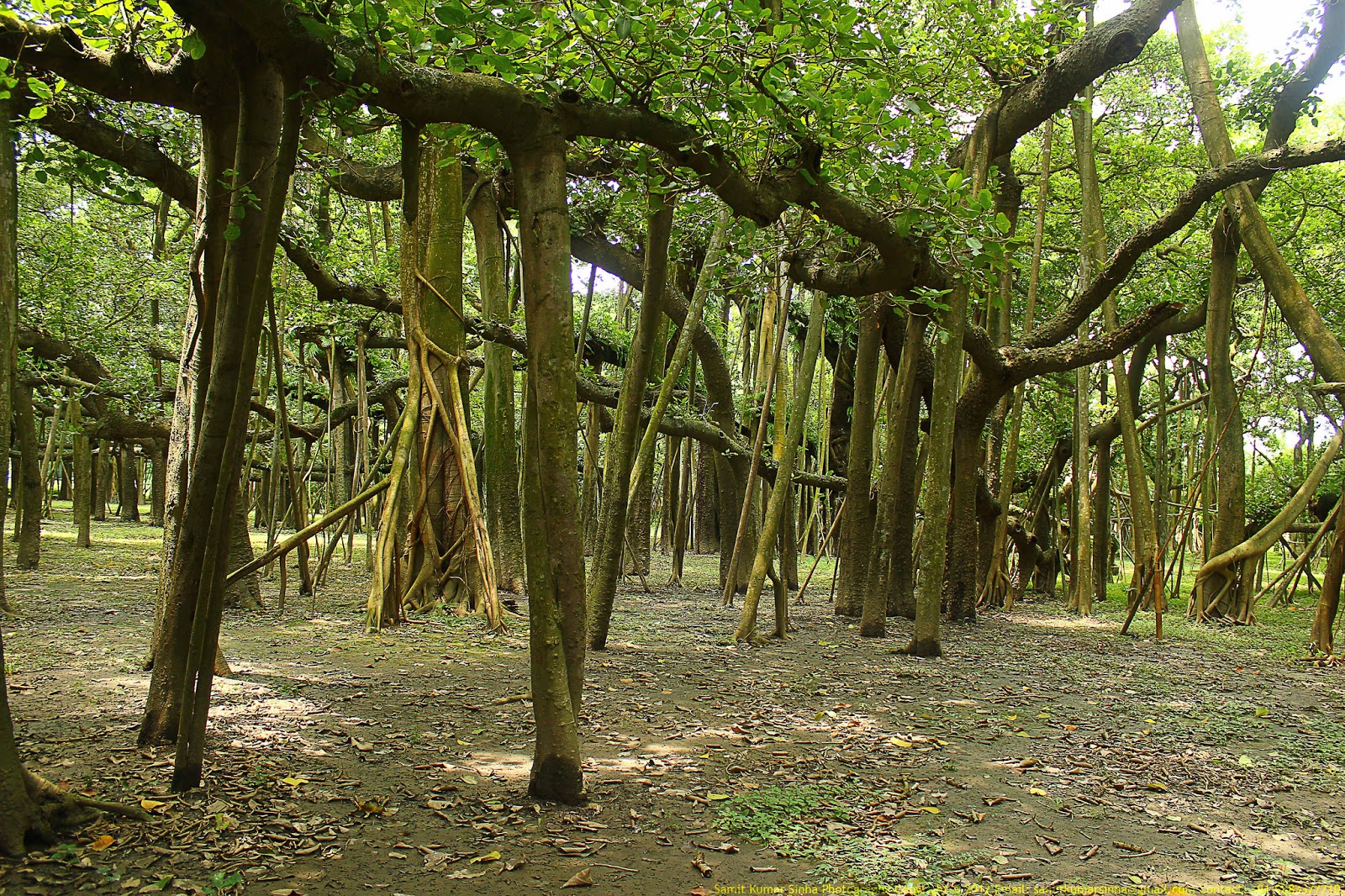
aerial roots, which grow from the branches and run vertically to the ground and looks like is has so many trunks. The great banyan tree has drawing ever increasing visitors to the garden than its collection of exotic plants from five continents. The Great Banyan used to induce the interest of photographers is perhaps the most photographed tree in the world. Amusingly, one would find barely any difference if one compares the photographs taken in 1850s and those being taken today.

You can easily called The Great Banyan looks more like a forest than an individual tree. The present crown of the tree has a circumference of 486 m with a highest branch is 24.5 m. The Banyan tree has 3,772 aerial roots reaching down to the ground as a prop root and occupied area is about 18,918 meters. The most interesting point is that, the tree still lives in perfect vigor without its main trunk, which decayed and had to be removed in 1925. Although, in 1925 it became diseased struck by lightning and was excised to keep the remainder healthy left it as a clonal colony rather than a single tree. Moreover, a long over 330 meter road was built around its circumference, but tree is continuously spreading beyond it. The tree fruit is not edible and is red when ripe. A monument has been erected to the dead trunk, but is hardly accessible to visitors, who only have access to the perimeter of the tree. 

Looking Glass Rock, Brevard NC


The Looking Glass Rock is located in the Pisgah National Forest near Brevard, of Western North Carolina. The sheer face makes it one of best rock climbing destination in the United States. It’s a heaven for hikers, sightseers, and photographer, comprised of striking Whiteside granite. The Looking Glass Rock name is derived from its majestic appearance, because whenever rainwater freezes on its surface, the sunlight reflects like a mirror. It’s a lifetime experience to see the sunlight reflecting from its surface. Looking Glass Rock from the side just look like a Helipad but the view from the top are well worth the effort! It is highly recommended do not get too close to edge, because it is very slippery and fall from top could be life threatening. 

Therefore, Geologists refer to it as a "pluton monolith" a huge ball of granitic rock that would have become a volcano had it not cooled before it reached the earth's surface. The striking landmark is rising 3,969 feet was formed roughly 390 million years ago.  It’s a big attraction among hikers, as 6.2 mile round trip tail offers terrific views after the climb to top. The Looking Glass Rock Trail climbs about 1700ft in just over three miles, following stream, small cascades, series of switchbacks up the mountain, tunnels of rhododendron and mountain laurel.

Moreover, Looking Glass Rock is a favorite place for birders, and prime nesting location of endangered peregrine falcon.  It is also consider landscape of waterfalls, like Moore Cove Falls, Looking Glass Falls, and Sliding Rock Falls among the most popular. Once you pop out on the cliffs, you will see at your feet, minor gullies have been carved into the rock by water seeping, soil, rocks, and forest duff that forms a thin cap on top of the mountain. Moreover, you can also lookout out the patches of water, pine needles, algae, or ice on the rock that could send you sliding as you search for that perfect spot for a photography. Moreover from the top of Looking Glass Rock, stunning panoramic views can be seen of the Blue Ridge Parkway and surrounding mountains of Transylvania County. Source: Charismatic Planet

Tuesday 26 April 2016

The Aqueduct of Segovia

The Aqueduct of Segovia is a marvelous Roman structure and one of the most noteworthy and best-preserved ancient monuments left on the Iberian Peninsula. More precisely you can call it Aqueduct Bridge, located in Spain, foremost symbol of Segovia, as evidenced by its presence on the city's coat of arms. In-fact it is city’s most vital architectural landmark had been kept functioning from several centuries and preserved in great condition. The Aqueduct construction date is not confirmed, however it is believed that it took place somewhere Ist century AD during the reigns of Emperors Domitian, Nerva and Trajan. 
The first reconstruction took place during the reign of King Ferdinand and Queen Isabella, when a total of 36 arches were built with great care without disturbing the original design. The unmortared brick like granite blocks used to construct aqueduct in Roman era. Moreover, the three tallest arches showing a sign in bronze letters, indicating the name of its builder. These days, two niches are still visible, one is Hercules and other is image of Virgen de la Fuencisla. The Aqueduct Bridge is built about 20.400 blocks of granite, 7.500 m3 of granite with a total weight of 20.000 tons. Hence the largest block in the bridge has a weight of 2 tons, and blocks of 1.000 kg are common.

The site was listed in the 2006 World Monuments Watch by the World Monuments Fund. Indeed the Aqueduct of Segovia is an exclusive structure, still carries its original character and remains a protuberant and evocative feature of the regional landscape.  It represents to aesthetics and functionality that are so strongly associated with the engineering prowess of the Roman Empire. The Aqueduct of Segovia functioned for many centuries after the fall of the Roman Empire and served the communities of Segovia well into the modern era. The aqueduct is special in every pillar and spandrel has a different design, have a common springer, others have separate but touching ones, and the base of several of the spandrels is different. There’re few arches in the center of aqueduct which were ruined during Muslims conquest of 9th century, however Catholic Kings had restored in the 15th century.

Well, the one of major purpose of building Aqueduct is to transport water from Rio Frio River 11 miles from the city in the La Acebeda region took 9.3 miles before arriving in the city. The water was first gathered in a tank and led through a channel to a second tower. The tallest aqueduct reaches a height of 28.5 meters, well supported by single and double arches to pillars. It provided water to Segovia until the mid-19th century. Nowadays it is well-deserving structure to pay attention in its continued protection and stabilization. The Aqueduct of Segovia remains one of the most intact Roman aqueducts in Europe.

The Aqueduct of Segovia structure stands 28.5 meters tall at its maximum height and nearly 6 additional meters deep in the main section. Along pillars and arches of its tall, two-story arcades are made of solid blocks of stone fit closely together with little or no mortar, and the lower arches alternate in height according to the structure’s adaptation to the contours of the land. This is not a religious site, but it is such a magnificent monument that we just can't bear to leave it out.  This is most visited and photographed sight in Segovia and the symbol of the city, its massive scale and state of preservation are unmatched anywhere in Europe. Unluckily, after surviving remarkably intact for nearly 2,000 years, the aqueduct is now being extremely threatened by the pollution and traffic vibrations of the modern world. Source: Charismatic Planet

Monday 25 April 2016

The Citadelle Laferriere Fortress

The Citadelle Laferriere is a massive mountaintop fortress in northern Haiti. It is one of largest fortresses in U.S. has itself become an icon of Haiti. A Haiti slave rebellion Henri Christopher built the fortress in the beginning of 18th century. In 1982, Citadelle Laferriere is included in the list of World Heritage Site by UNESCO. The massive stone structure is located approximately 17 miles south of the city of Cap-Haïtien and five miles uphill from the town of Milot. The fortress walls rise 130 feet from the mountaintop and the entire complex, including cannonball stocks but excluding the surrounding grounds, covers an area of 108,000 square feet.

The stone structure was constructed up to 20,000 workers between 1805 and 1820 as part of system of fortification designed to keep Haiti safe from French incursions. Workers laid fortress foundation on to the stone of the mountaintop, using a mortar mixture that included quicklime, molasses, and the blood of local cows and goats to the mix to give the mortar added strength and bonding power. The Citadel was constructed many miles inland to prevent attacks and provide a lookout into adjacent valleys. Moreover, Atlantic Ocean can be seen from the roof of fortress, and coast of Cuba, some 90 miles to the west on clear days. The local Haitians outfitted fortress with 365 cannons of varying size, obtained from different nations. However, mammoth stockpiles of cannonballs still sit in pyramidal stacks at the base of the fortress walls. Since its construction, the fortress has withstood many earthquakes, though a French attack never came and it was finally abandoned.

Well, Christophe was a shrewd person and during an invasion, his military burn the valuable crops and food stocks along the coast then retreat to the fortress setting ambushes along the sole mountain path leading to the Citadel. According to some legend, Christophe has committed suicide after shooting himself with a silver bullet; therefore his loyal followers covered his body in quicklime and entombed it in one of the Citadel's interior courtyards to prevent others from mutilating the corpse. The Citadel fortress has made National symbol in Haiti featured on currency, stamps and tourist ministry poster.

There’s ample space in fortress to store enough food and water for 5,000 defenders for up to one year. The Citadel's appearance from the trail leading up to its base has been likened to the prow of a great stone ship. The structure is angular and was intentionally put there by Christophe to diverge cannonballs if attacked and the Epaulette is a great example of using angles to deviate and deflect shots. The fortress has been repaired and refurbished several times since its construction, including in the 1980s with support of UNESCO and the World Monuments Fund, though little of it has been replaced and its design remains the same.

Therefore, as the time progresses the Citadel has converted into one of the most popular tourist destinations in Haiti. Moreover visitors may have to be paying a small fee and also encouraged to rent a horse for the uphill trek. Though, the first portion of the seven-mile trail is navigable by 4WD vehicle, although sporadic landslides and construction projects sometimes make this undependable. Various people live along the trail and retail souvenirs or drinks, such as fresh coconut juice, to travelers. Moreover keep in mind drinks are a necessity in the tropical heat. The trail is paved stone, usually smooth and in good condition. However, about three-quarters of the way up from the parking lot, visitors must complete the final portion on horseback or on foot.

Tuesday 19 April 2016

Enchanted Mesa, A Sandstone Butte in New Mexico


Enchanted Mesa or Mesa Encantada is a sandstone butte in Cibola County, New Mexico, United States, about 2.5 miles northeast of the pueblo of Acoma. It was home of the Acoma people until a massive landslide and severe storm completely demolished the only approach.  There are no longer any ruins on the flat top. The butte is 430 feet high, 1,250 feet long and only 400 feet wide, at its widest. The elevation at the top is 6,643 feet. It is believed that massive cliffs are formed by the Zuni Sandstone and the butte is topped by the Dakota Sandstone. 

In 1892 The Charles F. Lumins visited Acoma and express the story of Acoma People life style on Enchanted Mesa.  The access from southern side to top with a large piece of butte had spalled off and formed a ramp called stone ladder up to the top. So, there main source was their fields, springs, and water source were in the valley.  Therefore, once the summer season start, the entire village descends into the valley to tend the crops.  So, once an unfortunate day, a severe thunderstone washed away the stone ladder leaving only sheer rock faces all the way around the butte. Only one young boy and three old women did not leave in the village, which couldn’t get down nor could anyone else get back to the village. 

A giant thunderbird swooped down and scooped up the four and carried them to the valley floor. The Acoma people abandoned Enchanted Mesa and moved to White Rock Mesa, now called Acoma. In 1897, Professor Williams Libbey from Princeton University climbed Enchanted Mesa, where he spent two to three hours in exploring, however he didn’t find anything ruins or artifacts. 

Moreover another archaeologist Frederick Webb Hodge didn’t believe Libbey findings, and he went on expedition in 1897 and found evidence of occupation, arrow points, stone tools, beads and pottery fragments lodged in crevices. He said, main ruins had been washed over the edge by many centuries due to massive thunderstorms. In 1974, an Acoma police officer claimed, that he had seen a UFO over Enchanted Mesa, which was later confirmed by other police officers, a red light, fast than any aircraft. So, a helicopter was sent to top of Enchanted Mesa to find the evidence of UFO, however no direct evidence was found. 

Sassi di Matera: The Oldest Inhabited Cave City

In the Basilicata region, in Southern Italy, there’s an ancient city called “Matera” well-known for its cave houses called “Sassi”. The “Sassi” are carved into the cliffs of a rocky ravine formed by what was once a big river just left now a small stream. These cave dwellings are thought to be amongst the first human settlements in Italy dating back to the Paleolithic era, more than 9,000 years ago and is believed to be the oldest continuously inhabited cave city in the world.

Since then until as recently as the caves were continuously inhabited. The first human settlements in the territory of Matera took advantage of the region’s many natural caves that define the rocky landscape. Over time new caves were dug out to accommodate the growing population. At first glance the Sassi sprawl seems as a jumble of stone huts that impeccably merge with the spectacular landscape but behind the picturesque dwellings are tales of struggle.

Moreover, some of the earliest houses look like stone huts, but behind the house-like facades is meek caves. With the passage of time, the city developed, it became emerge into jumble of narrow alleys and stairways as residents dug wherever a cliff-face provided opportunity. Hence, until the late 20th century, the Matera region was one of the poorest places in Italy. Over the years new holes were continuously carved out to make room for the ever-increasing population dwellers took advantage of every bit of rock they could and many of the layered homes feature labyrinthine alleys and stairways. After WWII, cave residents were reluctantly moved from their crumbling homes into more modern abodes in the Matera town on the cliff. While many of the ancient chambers lie abandoned and forgotten, the settlement's prospects were hugely boosted in 1993. 

However, the area was without electricity or running water or sewage disposal facility. The public were lacked of basic needs because there were no shops in the village. Therefore, a typical diet comprised of bread, oil, crushed tomatoes, and peppers. Even, big families lived alongside their livestock, and in such unhygienic conditions, disease was widespread, particularly malaria. The extreme poverty of these people during Benito Mussolini's fascist rule was uncovered in the book “Christ stopped at Eboli” by an Italian doctor Carlo Levi. It is foreseeable that the picturesque caves' timeless surroundings have had their fair share of screen time. The landscape has been used for a range of biblical film and TV scenes including the 2004 Passion of the Christ.

After the Second World War, the new government tried to move the city’s cave residents into modern dwellings but many people were reluctant to move. Eventually, the government had to forcibly relocate the inhabitants to the new town on top of the cliff. Therefore, Matera’s fortune was changed after 1993 when UNESCO declared Matera’s Sassi and cave churches a world heritage site, bringing a fresh wave of inquisitive tourists. Since then several caves have been given a new lease of life and transformed into cozy homes, stylish hotels and restaurants to cater for waves of inquisitive tourists, eager to find out why Unesco was so impressed. Indeed this place is a good way of life. Cool in the heat of summer and warm in the winter, and no air conditioning of radiators to worry about. Back in the 70's it recalls seeing similar caves in the South of Spain, and with people still living in them.