Saturday 11 July 2020

Tree Root Cave, Kalaloch, Washington

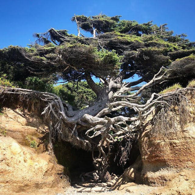
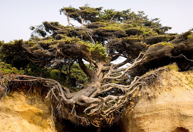
The power of nature stuns human beings. Nature shows a true example of how powerful nature is. On the north of Kalaloch, “Tree Root Cave” is an amazing marvel of nature. The feature in the tree of life is like no other has. People call it the “Tree of Life” with its stunning roots seemingly supplying the tree with life in spite of no soil. This seems an immortal nature, leaving humans speechless from a sight that has never been seen before that. Decades of erosion taken the soil supply, but never stopped the tree from thriving.

In the first look, there are several questions that come in mind, how has it not gone? Is this circle of life? How has another tree not taken over like it? Why nature is holding this tree without soil? Hence, with no one really knowing how it keeps ongoing. Therefore, it is famous as Tree of Life Kalaloch in Washington. The Tree of life WA is just 40 minutes from Manitou Lodge in Forks, WA. Moreover, underneath the tree is a cave-like hollow that some people call “the tree root cave”.

The magical tree standing without soil, and not fallen in the intense storms. Your brain will have no logical explanation for why it hasn’t toppled over yet. Surely, some magical nature power involved in the health of the tree. It doesn’t hurt by wind and rain and cemented without a soil anchor system. Many people believe the magical tree can withstand things that take down even the healthiest of trees, right?

The nature lover believes, it is a true example of a freak of nature that isn’t supposed to happen. The Tree of Life Washington goes against all the rules of science and biology. It shouldn't be standing. It shouldn't be alive. And yet, it is! At Kalaloch, it is long by the way... gorgeous coast, beautiful hikes, sunsets like nowhere else, cozy cabins, great food, friendly faces, etc. We could go on, but we're talking about a tree right now and it's a tree that must be seen in person, such as when you vacation at Kalaloch.

The “Tree of Life”, is a Sitka spruce, the largest kind of spruce, and one of Washington State’s most famous trees. This astonishing natural wonder has no official name. As a result, it has many names, the Kalaloch Tree, The Runaway Tree, Tree Root Cave (for the space beneath the tree), and The Tree of Life.

The Tree of Life is incredible – but it’s not the only reason to visit the Kalaloch area. “Kalaloch” is Quinault for “a good place to land” offers a variety of sandy beaches, trails, and scenic overlooks to discover and explore. Wildlife here includes sea otters, shorebirds, tide pools with crabs and sea urchins, clams, and even the occasional sight of whales and dolphins.

The lubin-king.com, written in 2005

“As we approached the tree a couple that was walking towards the bluff commented that they had been coming to this campground for 17 years and each year they had been expecting the tree to fall, but it hadn’t happened yet”
Tree Root Cave, Kalaloch, Washington

Tree Root Cave, Kalaloch, Washington

Tree Root Cave, Kalaloch, Washington


Also Read: The Alnwick Garden Poisonous Plants
Product You May Interested

Thursday 9 July 2020

Le Passage du Gois, France

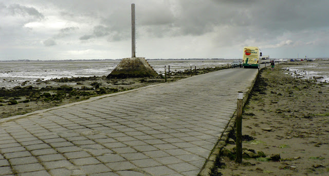
The Le Passage du Gois is a natural, periodically flooded passage that is leading to the beautiful island of Noirmoutier in France. The European country is famous for its beautiful beaches, mountains, architecture, and culture. Here in Passage du Gois has a fascinating road that is truly unique, hidden treasure, and a national monument of France.
The beauty of Le Passage du Gois is that when the path is flooded twice a day by high tide. It is located between Île de Noirmoutier and Beauvoir-sur-Mer, in the department of Vendée. The track is 2.5 miles long. Every year, a foot race – the Foulées du Gois – is held across it, starting at the onset of the high tide. This beautiful road of France is only accessible during the low tide and only 1 ½ hour before the tide and 1 ½ hour afterward.

Tourist Spot

This stunning occurrence gathers thousands of visitors each year to see the “miracle”, while several in busy collecting clams and oysters. Due to flooded water, the road conditions deteriorate and paved many times. If you go there then you should be very careful in observing the disappearance of the road, as the water level reaches more than 15 feet. However, safety signboards are displayed on both sides of the passage. Whenever you go to France, then Le passage du Gois is a must-see lifetime experience. Indeed this causeway is so distinctive, that you cannot encounter it anywhere else in the world.

History of Le Passage du Gois

In the 9th century, Passage du Gois was first mentioned. However, in 1701, it appeared on the map. People faced a lot of difficulties in the 18th century and they went on foot over the sand-banks to the island of Noirmoutier. Eventually, an official road constructed in 1832. Its importance was converted secondary when a bridge was build between the mainland and Noirmoutier in 1971.

Tour de France

According to Wikipedia France famous tour, de France bicycle race was held during stage 2 in Passage du Gois. Therefore, the bicycles face a lot of difficulties in cop the slippery surface. A fall took place and the crash created a 6 minute split in the peloton which finished the hopes of several bicycles to win the race like Alex Zulle. Who would eventually finish second overall, seven minutes after Lance Armstrong? After 12 years, the Passage du Gois was again used as the starting point of the first stage.
Le Passage du Gois, France

Le Passage du Gois, France

Le Passage du Gois, France

Le Passage du Gois, France

Le Passage du Gois, France

Le Passage du Gois, France

Le Passage du Gois, France

Le Passage du Gois, France

Le Passage du Gois, France

Product You May Interested

Wednesday 1 July 2020

The Stone of El Peñol

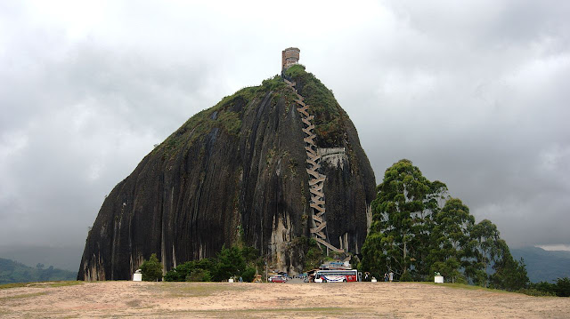
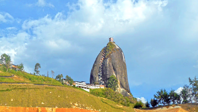
The Rock of Guatape, is an iconic landmark inselberg also famous as “The Stone of El Peñol” located in the border of two towns Guatapé, and El Peñol Antioquia in Colombia. Hence, both towns claimed ownership of the Rock Guatape. The Guatape Rock has also historically claimed the rock as their own and thus has led to various names for the site. The landform is a granitic rock remains that has resisted weathering and erosion, probably as result of being less fractured than the surrounding bedrock. The town of Guatape is a major tourist attraction, particularly for travelers from Medellín, for both El Peñón de Guatapé, and the famous zócalos that adorn numerous buildings.

The Guatapé is an outcrop of the Antioquia Batholith and towers up to 656 feet above its base. Tourists can scale the rock via a staircase built into one side, a path that includes more than 649 steps to the top. Number of food and markets stalls available near the base of the Rock. About halfway up the stairs, there is a shrine to the Virgin Mary. The summit contains a three-story viewpoint tower, a convenience store, and a seating area.

The indigenous South American agricultural tribe Tahamí, former inhabitants that region, superstitions and worshiped the rock and called it in their language mojarrá or mujará. In 1954, the rock was first climbed by three climbers Luis Villegas, Pedro Nel Ramirez, and Ramón Díaz in a five-day endeavor, using sticks were embedded in the fissure on the rock. Hence, the staircase was built later on to allow people to climb to the rock without needing particular equipment.

Pitcairnia heterophylla (A new species of plant) was found on the top of the rock. The beautiful viewing spot was built on top of the rock. Here, visitor can buy different handicrafts, souvenirs, postcards, and other local goods. It is possible to see the five hundred km shore-perimeter dam. There are 740 steps to the uppermost step atop the building at the summit, a fact reinforced by yellow numbers also seen in the climb up the stairs. In the 1940s, the Colombian government declared it a National Monument.

According to Wikipedia On the western face of the stone there are painted large white letters "G" and an incomplete "U" (only the single vertical stroke was completed, resembling an "I"). The towns of Guatapé and El Peñol had long disputed ownership of the rock, and the residents of Guatapé decided to settle the matter by painting the town's name on the rock in huge white letters. It did not take long for the residents of El Peñol to notice the work, and a huge mob was assembled to stop it. Only the "G" and part of the "U" were completed.

The rock rises from the bottom of the hydroelectric dam of Peñol-Guatapé. This monolith was spotted as a border landmark between country farms and the two cities of Guatapé, and El Peñol.  At its highest part, on the rear southeast side, it has an elevation of 7,005 ft above sea level, with an average temperature of 18 °C. The massive rock "Peñol" is 935 ft long and 360 ft wide. It has some rock breaks, one of which was used for the construction of 650 steps of the stairway that can be used to go to the top.

The Stone of Peñol is mix of minerals such as of quartz, feldspar and mica. The view from atop of this 70-million-year-old rock is unimaginable an enormous lake full of small islets. The rock is easily visible for miles from the surrounding countryside. There are very few travelers leave Medellin without making a visit to this pre-historic massive rock. Even today, researchers are uncertain how the rock was formed or where it has come from.


The Stone of El Peñol

The Stone of El Peñol

The Stone of El Peñol

The Stone of El Peñol

The Stone of El Peñol

The Stone of El Peñol

The Stone of El Peñol

The Stone of El Peñol

The Stone of El Peñol

The Stone of El Peñol

The Stone of El Peñol

The Stone of El Peñol

The Stone of El Peñol

The Stone of El Peñol

The Stone of El Peñol

Sunday 28 June 2020

Dar al-Hajar – Yemen

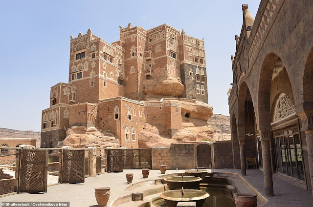
Yemen's Dar al-Hajar – or 'stone house' is a rock column behold one of the world's most spectacular constructions. The former royal residence grows out of the rock pinnacle upon which it’s perched. The Dar al-Hajar or “Rock Palace” is located in Wadi Dhar, around 15 km (9 miles) from the capital city of Sana, Yemen. It seems to grow out of the rocks on which it is constructed and it has the characteristic painting of its windows and edges. Yemen’s architecture Dar al-Hajar palace, built atop a tall natural rock spire is nevertheless fantastical.

The five-storey building looks incredible from every angle. So, it won’t be surprised to see Dar al-Hajar on a Yemeni currency note (the 500 rials one). In 1920’s Islamic spiritual leader named Yahya Muhammad Hamiddin (ruler of Yemen from 1904 to 1948) stayed here as a summer residence. This place didn’t leave good memories for Imam Muhammad Yahya as his grandson assassinated him during a coup in Yemen in 1948. Nevertheless, the palace did remain in the ownership of the Yemeni royal family until the Yemen 1962 revolution.

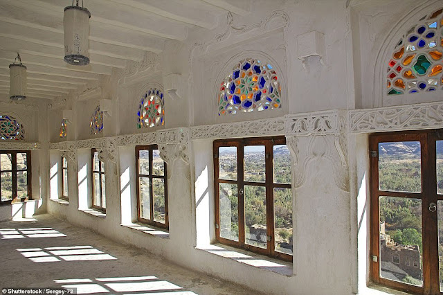
However, Islamic scholar Imam Mansoor Ali Bin Mehdi Abbas constructed atop of the structure on the rock column. This beautiful building has multiple facilities of kitchen, storage area, guest rooms, and sedate courtyard leading through the five-story structure. The main feature of this building is to look like a fortress with shooting emplacements to defend the place from attackers. Therefore, it’s indeed easy on the eye, though designed to withstand attack and its own water supply from deep below the rock', meaning it could 'easily have withstood a siege'.

Now it’s a popular example of Yemeni architecture for tourists, who can see the rooms and explore the labyrinth of staircases. Now Dar al-Hajar has a museum, and tourists paid a visit to the palace have sung its praises on the internet. Its a fantastic place and one of the best things you will see in Yemen. You will have a wonderful experience to see this old Yemeni palace and understand more about the local life and culture.' It is nothing like you have ever seen before to pay a must-visit and relish the exquisite view. The majestic five floors offer enough to relish, but walking around at its base is equally impressive and heightens your admiration.

Dar al-Hajar – Yemen

Dar al-Hajar – Yemen

Dar al-Hajar – Yemen

Dar al-Hajar – Yemen

Dar al-Hajar – Yemen

Dar al-Hajar – Yemen

Dar al-Hajar – Yemen

Dar al-Hajar – Yemen

Dar al-Hajar – Yemen

Dar al-Hajar – Yemen

Dar al-Hajar – Yemen

Dar al-Hajar – Yemen

Dar al-Hajar – Yemen

Dar al-Hajar – Yemen

Product You May Interested

Wednesday 24 June 2020

Aloba Arch - Chad

A Natural large Aloba Arch is located in the complex mountainous Ennedi Plateau of Chad. Large natural arches are somewhat rare outside the southern and western regions of China and the Colorado Plateau of the southwest United States. This natural wonder is built by water and wind over millions of years ago. Aloba Arch is located within the remote corner of Sahara Desert in the northeast part of Chad near Libya and Sudan.

This has similar geology to the Colorado Plateau and has produced a number of natural arches and related landforms. However, Only Aloba can claim to be on the top ten lists of the longest arches in the world. Its altitude reaches approximately 120 meters, making it one of the highest arch in the world. Central Africa, natural Aloba Arch is one of the most famous and least visited natural monuments on the planet earth. Some preliminary data showing, that sandy Aloba Arch was formed millions of years ago under the extreme influence of water, wind, and erosion.  

Moreover, Aloba Arch's span is considered to be the eighth longest known natural arch and the longest outside of Utah and China. Due in part to its location as well as being only in recent times recognized for its size, estimates based on taking pictures yield an estimated span of 250 ft. China’s Fairy Bridge (Xianren Bridge) has a span of 400 ft which is the longest discovered and measured span to date.

Possibly more outstanding than the span, though, it is the sheer height of the arch. Aloba Arch is 394 ft tall towers over the more famous Rainbow Bridge and is one of the tallest known arches in the world. Many tourists hesitate to manage long journey through the boundless African expanses. The nearest city to this landmark is Fad. Due to remoteness, this stunning geological object hasn’t gone through in a proper way, and its age, feature, and formation are not cleared.

Therefore, it is not surprising only a few daredevil tourists visit the Aloba Arch, part of the mountain range that does not detract from its geological and visual merits. The Aloba Arch is extremely difficult to place to reach there, as Chad’s don’t have international tourism facilities that are virtually non-existent. Hence, this place is one of the rarest bucket list and most pristine natural places in the world. 

Aloba Arch - Chad
Aloba Arch - Chad

Aloba Arch - Chad

Aloba Arch - Chad

Aloba Arch - Chad

Aloba Arch - Chad

Product You May Interested

Monday 22 June 2020

Rainbow Bridge National Monument – Utah, United States

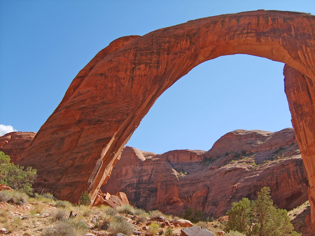
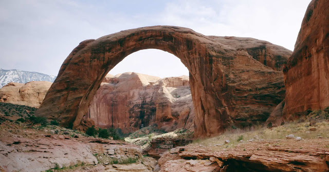
Rainbow Bridge is often considered as the World’s Highest Natural Bridge in Southern Utah, United States. The span of Rainbow Bridge is approximately 290 ft tall, spans 275 ft and the top is 42 feet thick and 33 feet wide. The Native American tribes regarded the bridge as cultural importance.

The two famous natural arches, Landscape Arch and Kolob Arch are longer than Rainbow Bridge in Southern Utah. However, they are arches, and the rainbow is a bridge. The Chad Aloba Arch has outdone with 394 feet. Finally, Xianren bridge (Fairy Bridge) in Guangxi Province has a span of about 295 feet and a height of 210 feet, appears to be the largest span natural bridge in the world. Therefore, the world’s tallest arch is Toshuk Tagh in China at an estimated 1,200 feet.

Rainbow Bridge is accessible by a two-hour boat ride on Lake Powell followed by a mile-long walk from the National Park wharf in Bridge Canyon, or by hiking several days overland from a trailhead on the south side of Lake Powell.

Rainbow Bridge is made from sandstone firstly deposited by wind as sand dunes, during the Jurassic times. The severe fluctuations in climate were alternately a sea and desert on par with the Sahara—produced layers of sandstone with different levels of hardness. However, by the end of the Jurassic, the sea returned to cover these layers of sandstone and compressed them so tightly that they would persist until the present day.

Rainbow Bridge is located in the rugged, isolated canyons at the feet of the Navajo Mountain. Native Americans knew the bridge as scared for many centuries as a symbol of deities responsible for creating clouds, rainbows, and rain. Many Native American families are still living here. In the early 18the century, cowboys, prospectors, and wandering trappers saw the Rainbow Bridge and did not notice too much. In 1909, Rainbow Bridge's existence came to know by the outside world. In the 1930’s former U.S. President William Howard Taft declared Rainbow Bridge National Monument.

In 1924 a road was built from Red Lake to the West side of the Navajo Mountain. Also, construct a rustic stone building and facilities for mules and tourists, named it Rainbow Lodge. Zane Grey and Teddy Roosevelt was the first tourist to make the trek by foot and horseback from Oljetor to Navajo Mountain. Then they established a trail till Cliff Canyon, then over Redbud Pass to Bridge Canyon. One can make 14 miles trip in one day by horse or mule.  

In the 1930s tourists use the jet boat from Lee’s Ferry to reach the Rainbow Bridge. However higher water made motorboat access to Rainbow Bridge is a little easier bringing thousands of visitors each year. Whenever you go there, be respectful of its significance. Tourist approach and walk under the bridge from one side to the other above the creek bed. The average temperature at the bridge during the summer 37.7 degrees Celsius, and in the spring and fall are moderate, 23.8 degrees Celsius. The best time to visit Rainbow Bridge National Monument is April, May-early June, September, and October.
Rainbow Bridge National Monument

Rainbow Bridge National Monument

Rainbow Bridge National Monument

Rainbow Bridge National Monument

Rainbow Bridge National Monument

Rainbow Bridge National Monument

Rainbow Bridge National Monument