Sunday 29 May 2016

The Natural Bride of Virginia


Natural Bridge Virginia has been designated as a Virginia Historical Landmark and a National Historical Landmark, located in the beautiful Shenandoah Valley at the intersection of history, culture and natural beauty. The Natural Bridge is nestled between the Blue Ridge and Alleghany Mountain ranges and surrounded by over 58,000 acres of National Forest, have anything your adventurous heart desires. Natural Bridge Virginia is 15 miles south of Historic Lexington Virginia, 35 minutes north of Roanoke Virginia, and only 15 miles from the Blue Ridge Parkway milepost 62. The 
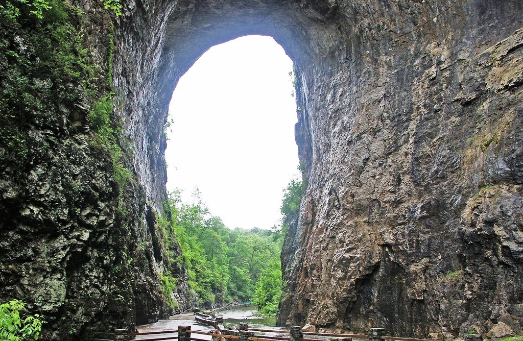
Rocks, limestones and dolomites indicate deposition approximately 470 million years ago. Although the process of formation of the bridge is not confirmed, but the thoughts proposed by different individuals have in common the importance of three elements: the southeast dipping of the strata, the capability of water to slowly dissolve carbonates and the existence of numerous fractures. 

Come see why Natural Bridge Virginia offers the best tourist attractions in Virginia. The magnitude and beauty of the Natural Bridge, compels many visitors to come to the area provides a unique, historic, picturesque and natural experience. One of our nation’s most iconic natural landscapes is now protected in perpetuity. Natural Bridge once ranked with Niagara Falls as one of the two natural wonders of the New World. The Natural Bridge was eventually eclipsed by the Grand Canyon and Yellowstone’s geysers but remains plentiful of a draw that other attractions have sprouted around it, including a wax museum, a safari park and Foamhenge, a plastic foam reproduction of Stonehenge.

Although, Natural Bridge was a mountain retreat, drawing countless visitors to capture nature-sculpted arch that soars high above cedar creek. Once among most visited natural wonders as one of 7 Natural Wonders of the Modern World. It is often cited as having a place among the enormous natural limestone arch. The arch was created when an ancient cavern collapsed leaving only the largest natural land bridge on the North American continent. Moreover, the other attractions in the area include a wax museum and a living history Monocan Indian Village. The beautiful trail under the bridge also furnishes an access to other attractions such as a recreation of Monacan Indian housing, Lace Falls, the "Lost River" and the Saltpeter Cave. Some researchers believe, the Natural Bridge would be the remnant of an underground river tunnel that diverted water to the south. Moreover the Natural Bridge was a sacred site of the Native American Monacan tribe, who supposed it to be the site of a major victory over pursuing Powhatans centuries before the arrival of whites in Virginia.

Well the 215-foot-long bridge was sacred to the Monocan tribe, and was revered by the American colonists. The site was surveyed in 1750 by a young George Washington, who allegedly carved his initials into the rock. Thomas Jefferson called Natural Bridge "the most sublime of nature's works" when he purchased 157 acres of land, including the bridge, from King George III of England in 1774. Perhaps the oddest parts of this natural wonder are "The Drama of Creation," a Biblically-themed evening light show that has been projected onto the bridge every night since 1920. The show is the longest continuously running light show in the US. Natural Bridge was one of the major tourist attractions of the new world that Europeans visited during the 18th and 19th centuries. Inviting tourists from all over the world took day trips from Natural Bridge on horseback or horse-drawn carriages to explore the countryside. 


Saturday 28 May 2016

The Hand of Desert in Chile

Somewhere in the Atacama Desert of Chile lies an astonishing monument “Mano del Desierto”, or the Hand of the Desert. In first look, it seems to be a science-fiction item, but actually it is a 36 feet high sculpture. However “Mano del Desierto” is a symbol of the contrasting ideas which shows how small, helpless and stranded humans are. The Chilean Artist Mario Irarrazabal has created this massive hand sculpture popular in his domain of sculpting hand made things. In fact weird as they may seem, and his efforts are acclaimed all over the world due to their innovative and emotion they express. 

The nearest town from this monument is Antofagasta around 75KM away. Nonetheless, visitors are crazy to see this marvelous effort of Mario Irarrazabal, and have catches surprise popularity throughout the year. Irarrázabal used the human figure to express emotions like injustice, loneliness, sorrow and torture and it is an easy victim of graffiti and is therefore cleaned occasionally.

However, it was built around nearly 25 years ago in March 28, 1992, seems just as if it was made of sand the sculpture is very resistant. The local organization “Corporaction Pro Antofagasta” support in construction of Hand, made by iron and cement. It’s a must visit place can be visited any time of year. His another popular works include an over-sized sculpture exploring the same idea, named "Monument to the Drowned" is located on Parada 4 at Brava Beach in Punta del Este, a famous resort town in Uruguay. 

Friday 27 May 2016

The Incredible Water Chemistry of Watling’s Blue Hole

The Watling’s blue hole is located on the Bahamian island of San Salvador. The karst feature Watling’s blue hole is formed by the erosion of limestone, actually made of calcium carbonate, a mineral that can dissolve in water especially in acidic water. When the limestone dissolves, it gives off carbonic acid, and even more able to dissolve limestone.

Once, the limestone dissolves the remaining part abruptly dissolves more, and result in formation of a deep blue hole around the spot where the limestone first began dissolving. In fact, Watling’s Blue Hole has incredible water chemistry, has no fresh water anywhere not even a tiny lens on top. Therefore, this hole must link all the way to the ocean to let salt water flow in constantly to dominate the system. The blue hole is sitting in the middle of rainy Tropical Island, indicating that the hole must be connected to the ocean by an underground tunnel. 

The Magical Spotted Lake, Canada


Spotted Lake is a saline endorheic alkali lake draws countless visitors from around the world located near the city of Osoyoos in British Columbia Canada. The Lake has rich of minerals such as magnesium sulfate, calcium and sodium sulphate and contains extremely high concentrations of minerals such as silver and titanium. In summer, Lake Water evaporates leaving behind colorful mineral deposits. The ameoba-shaped Spotted Lake, changes colors throughout the year and during the summer time divides itself into white, green, blue and yellow pools. It is said that the lake has the highest natural concentration of this mineral in the world. 

The colorful large spots appears according to mineral composition, Magnesium sulfate normally crystallizes in summer play a major role to spot color and remaining minerals in the lake harden to form natural walkways around and between the spots.  Nowadays, the spotted lake is surrounded by a fence to keep people off, but you can get a good view of it from the highway.

These minerals were used in the manufacture of ammunition during First World War. Chinese labour force skimmed up ton a day of salts from Lake Surface and shipped them to munitions vendors in eastern Canada. Later on, the site came under the control of the Ernest Smith Family for a term of about 40 years. The Ernest Smith attempted to create interest in a spa at the lake in 1979. 

Spotted Lake is a strange and significantly important site having great potential of commercial exploitation presently hype much controversy. The native peoples used the lake mud and water for the treatment of aches and ailments. Therefore, officially, Spotted Lake is on private land and therefore theoretically not accessible for close up observation. It is actually recognized to the First Nations of the Okanagan Valley as Kliluk. The spotted lake is surrounded by cairns rock piles often indicating graves. You cannot miss this historic landmark as you drive along the highway just west of the city. A lot of people stop on the side of the road for a longer look.  


Thursday 26 May 2016

The White Water Terraces of Baishuitai


Baishuitai is a village (also known as White Water Terraces), between Lijiang and Shangri-La County in northwestern Yunnan province, China. It is famous for its natural minerals terraces and located foothills of north of Haba near the upper Yangtze River valley and southeast of the Shangri-la county. Baishuitai is 140 meters from its base to top and 160 meters in width. It is snugly carved into a mountain slope more than 2380 meters above sea level, making Baishuitai the biggest limestone terrace in China. The beautiful terraces, just like waving clouds and white snow, the silver terraces stretch for miles, as clear as crystal, the spring’s meander, which seem to be frozen on the terraces? The Baishuitai Terrace is a symbol for a growing flower, and the white color represents auspiciousness and sanctity. 

It is recognized as one of the most eye-catching destinations in mysterious Shangri-La and is an ancient Chinese landform with a history of 200,000 to 300,000 years. The spring water from the higher reaches of Haba Snow Mountain reaches down into the uppermost terraced basin then spills over to the basin below, which it fills up before spilling over to the next basin, and so on and so forth, until the water spills over the outer rim of the last of this set of terraced basins. Therefore, it is composed by the sediments of high calcium carbonate in the spring waters normally flow downwards from the mountain to every semicircular-shaped limestone steps. From the many centuries it has resulted into make natural terraces look as the white marbles. Moreover, the basins themselves have been hollowed out over time by the erosive action of the acidic water, which in earlier times, drew out certain minerals from the limestone, creating weak carbonic acid.

Furthermore, The Baishuitai is also the birthplace of Dongba culture & values of the Naxi Minority Group. The one of their saint of the Dongba Religion was attracted by the captivating scenery of this place on his way back from Tibet. He decided to stop there and in full swing spreading his beliefs. So fallacies prevail among peoples and they consider Baishui Water Terraces as a shrine. Since then every year, on the eighth day of the second lunar month (8th February), the Naxi people will gather here to rejoice their traditional festival by dancing and singing all day and night. The people slaughter chickens to make the festival ends with smearing chicken blood on the branches around Baishuitai Water Terraces to show their affection & love. 

A difficult mountain road leads to the Baishuitai, almost three hour drive from Shangri-la. In-fact Baishuitai is a stunning, scenic, peaceful and worthwhile place. This is perfect place for photography, so all photographers can take some majestic clicks here.