Friday 24 October 2014

Athabasca Falls Canada


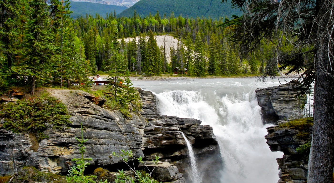
The Athabasca Falls are among the most potent and breathtaking falls in the Rocky Mountains capture the brilliance of rainbow-hued spray or the dazzling sheets of ice suspended from jagged rock on film. Athabasca waterfall is situated in Jasper National Park on the upper Athabasca River, about 30 kilometers south of the town site of Jasper, Alberta, Canada, and just west of the Ice fields Parkway. Athabasca is a powerful waterfall, comprises unbelievable natural scenic beauty, and is not known so much for the height of the falls 23 metres.

The waterfall is recognized for its force due to the huge quantity of water falling into the gorge. Moreover in a cold morning in the fall, the river levels tend to be at their lowest, abundant amounts of water flow over the falls. The huge mountain poised over the falls is Mount Kerkeslin, which was named by Sir James Hector of the Palliser Expedition in 1859. The river falls over a layer of hard quartzite and through the softer limestone below carving the short gorge and a number of potholes. The waterfall can be safely viewed and photographed from several platforms and walking trails around the falls. The approach to fall is from the nearby parking lot, which leads off Highway 93A just northeast of the falls. Highway 93A takes off from the nearby Ice fields Parkway and crosses the falls on the way north to the town of Jasper.

White water rafting often starts below the falls to travel downstream on the Athabasca River to Jasper. Athabasca Falls is actually one of the major tourist attractions along the Ice fields Parkway and is a very busy place on a midsummer’s day. If you want to avoid the crowds it is best to visit early in the morning or after dinner time. Most of the trail system is paved but stairs limit access for people in wheelchairs. There is a perfect picnic area with ten picnic tables, kitchen shelter and washrooms are available and great cross-country skiing in winter.

The falls itself wasn't particularly mind-blowing, but it possessed enough power to carve out a bit of a gorge immediately downstream of it. The huge numbers of peoples visit Athabasca Falls but do not give it adequate time. They rush to the falls; snap a picture and they’re gone. Then why not poke around? This is ideal time to explore the area looking for signs of abandoned waterfalls and other water worn rock. Stand in the spray at the closest viewpoint, or just hang out and enjoy the view.

Sunday 19 October 2014

Ventisquero Colgante (Hanging Glacier) of Chile


Ventisquero Colgante, or the Hanging Glacier, is found in the Queulat National Park, in Chile. It is the biggest attraction of Queulat National Park. This is hanging above a ravine of bare rock; and it dominates a valley formed by mountains covered in valdivian temperate rainforest, and feeds a river at the bottom of the valley as it melts. The water melting from the glacier makes two towering waterfalls which drops around 600 meters on top of a massive slab of angled bedrock, and then flows beneath what appears to be a perpetual avalanche cone. When the stream leaves this underground section, it creates a beautiful small lake called “Laguna Témpanos” and then after around six kilometers it enters the Canal de Puyuhuapi. Well, the falls are noticeable and flowing all-round the year but due to the ablation of avalanches at the base of the falls, as much as half of the falls can be covered by snow and ice during the late spring and early summer.

The lovely Ventisquero Colgante falls was discovered in 1875, when an exploration led by Captain Enrique Simpson. The Captain Enrique reported that the snow of the glacier was fair 100 meters from the bank of Canal de Puyuhuapi, where Captain used to moor his boat. It is not completely clear whether he saw the waterfall or this waterfall was visible at all. In all probability, it wasn’t. The waterfall was formed much later, as the glacier retreated and the cliff wall became visible. If Captain Enrique observation is factual, then the glacier has retreated 8 kilometers during the last 140 years.

True Natural Water Wonders of Bourke's Luck Potholes


The gorgeous Bourke's Luck Potholes are a true natural water feature located within the Mpumalanga province of South Africa, approximately 35 kilometers north of Graskop on the R532 road. It is found at the beginning of the Blyde River Canyon, these cylindrical potholes on the bedrock have been carved more than thousands of years ago with sand and pebbles swirling around in whirlpools at what time the Treur River plunges into the Blyde River. Originally, water borne pebbles carved out minor depressions, which soon trapped river debris additional accelerating erosion. Therefore hollows grew with the passage of time and got deepened to cylindrical potholes up to quite a lot of meters deep.

The potholes were titled after an ineffective gold prospector called Tom Bourke who revealed signs of alluvial gold in the canyon in the late 1880s. He swiftly staked a claim and originated to pan for gold. Unluckily for him, Bourke never stuck gold, though hundreds of others found riches just south of where he projected the presence of the precious metal. Bourke’s gold mine proved to be totally unproductive but his splendid legacy lives on at Bourke’s Luck Potholes. Unluckily, certain tourists treat Bourke's Luck Potholes as a “wishing well” and several have dropped coins into the potholes. A small visitor’s center is found close that offers information about the canyon’s origins and the flora and fauna found in the area. From there, the viewing point for these potholes is 700 meters away.

Taroko Gorge Taiwan


Taroko Gorge is also famous as “Marble Gorge” due to ample supply of marble in the region. It is an impressive 19-kilometers long canyon, found at north of Hualien on Taiwan's east coast, not far from the Pacific Ocean. Taiwan this part is rising because of the subduction of Philippines Sea Plate under the Eurasian Plate. More than hundred million years ago, the massive pressure lifted the region above the surface of the ocean, which in result the heat and pressure turned the limestone rocks into marble. Ultimately, the erosive power of Liwu River carved a path via the marble to form Taroko Gorge.

The Taroko Gorge is situated approximately 60 kilometers from the coast, which is home to some of the tallest peaks in Taiwan at more than 3,400 meters. Until the 1950s only a trail ran through the gorge. Nowadays the Central Cross-Island Highway runs across the wall of the gorge. Notwithstanding its name, the Central Cross-Island Highway is a slender and winding mountain road with plentiful bends. The Tunnel of Nine Turns is a widespread spot that takes drivers dramatically near to the edge of the gorge. This part is now firmly pedestrians only as vehicular traffic is routed through another tunnel.

Therefore; the Central Cross-Island highway is listed as one of the most treacherous roads because of the rugged and uneven terrain. Heavy rain from typhoons often dislodges soil and rocks onto the highway making sections of it impassable. Flooding happens widely both as a result of the amplified discharge of the river and as a result of water cascading onto the road from the neighboring cliffs. This area is prone to seismic activity. As one drives through the gorge, they will encounter various tourist spots including a Zen monastery, and an old settlement of Truku aboriginals now with museums and handicraft shops. The gorge terminates at a small village of Tiansiang where there is a lovely pagoda and a temple.