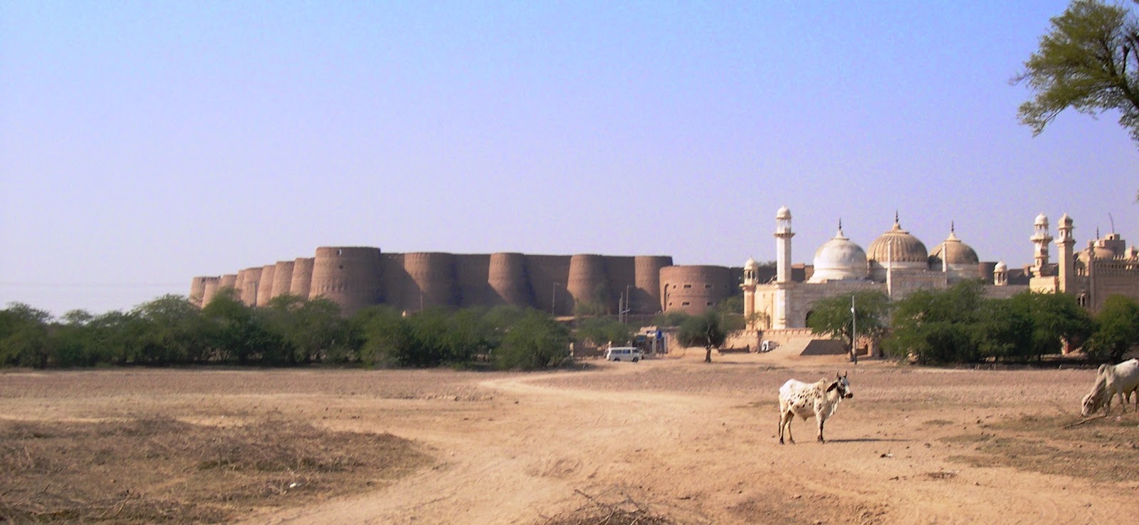
Tuesday 29 July 2014

Derawar Fort Bahawalpur Pakistan


Derawar Fort (Qila Derawar) is built by Hindu Rajput Rai Jajja Bhati of Jaisalmer in the Cholistan desert of Bahawalpur Pakistan. Derawar Fort is a large square fortress in Pakistan in Bahawalpur. The Derawar Fort is 100 Km from Bahawalpur, actually the largest and most superlatively preserved fort of Cholistan. The forty bastions of Derawar are visible for several miles in Cholistan Desert. The walls have a circumference of 1500 metres and stand up to 30 metres high. The fort was occupied by Royal Family of Jaisalmer until by the Nawabs of Bahawalpur in 1733.

In 1747, the fort ownership slipped from the hands of the Abbassi owing to Bahawal Khan's preoccupations at Shikarpur. Nawab Mubarak Khan took the stronghold back in 1804. The adjacent mosque was modeled after that in the Red Fort of Delhi. There’s a royal necropolis of the Abbasi family, which still owns the stronghold. The area is wealthy in archaeological artifacts associated with Ganweriwala, a vast but as-yet-unexcavated city of the Indus Valley Civilization. Derawar Fort is in good condition; its walls are intact and still guarded by soldiers in fezzes, however its age is unidentified. But the tombs of the Amir’s of Bahawalpur are also at Derawar, decorated with attractive blue glazed tiles contrasting with the ochre landscape. Some of the cannons which were used times ago by the Army of Bahawalpur are also kept in this fort.

Qila Derawar is an interesting excursion for a full day trip requiring a four-wheel drive vehicle to relish the beauty of Derawar Fort. The drive takes 3 to 4 hours through fascinating barren landscape. However; you’ve to take permission from the present Amir of Bahawalpur to get inside of the fort. The potent fort is measuring a 672 feet in length on each side, with a gate on its southern side approached by means of a winding ramp. Most of the bastions show geometric designs made by burnt bricks. A number of buildings in the fort provided quarters for Nawab’s army. The retiring quarters of the royal families are still stand deserted inside the fort. The beautiful four shrines of devout Muslims are sited near Derawar Fort. The Derawar Mosque, having three domes and four minarets, is an exact replica of Moti Masjid at Red Fort Delhi, and was built in 1844 A.D. Derawar Fort was stunning in their era and according to historical accounts Derawar is considered a pre historic and pre Harapen settlement.Source: Charismatic Planet

Sunday 27 July 2014

Spectacular Iceland Landscape Pictures at Night


The Spanish based photographer David Martin Castan worked primarily between dusk and dawn to capture marvelous pictures of the natural landscape bathed in remarkable colors.The beautiful Iceland is a home to roaring waterfalls, snowcapped mountains, ice caves, and stunning volcanoes truly comes alive in David Martin stunning nighttime scenes. 

Ethereal colors light up the photographer's imageries, addition a sense of otherworldly beauty to the melodramatic landscape. The eerie, green glow of an aurora borealis; the outstanding blue hues of an ice cave; the rosy, violet reflection of dawn on chunks of ice; golden rays from the setting sun illuminating an empty shore Castan's pictures perfectly capture the unearthly beauty of Iceland, motivating a serious case of wanderlust in anyone who has not yet had the chance to witness the awe-inspiring wonders of the Land of Fire and Ice. It’s must see country for every travelers. 

The Petrified Waterfalls of Hierve el Agua Mexico


One of the most eye-catching natural attractions in the Central Valleys of Oaxaca, Hierve el Agua provides an unusual and off-the-beaten-path travel experience. It’s a top ecotourism destination in Oaxaca, particularly popular among naturalists, hikers and photographers. Hierve el Agua is located in the Mexican state of Oaxaca, about 70 km east of Oaxaca City, and 14 kilometers southeast of the town of Mitla. In Spanish Hierve el Agua means “the water boils”, and the name derives from the bubbling natural mineral springs that are originate here, that run into bathing pools on a gorgeous cliff-top location. When you see Hierve el Agus from some distance you’ll feel that a massive waterfalls frozen on the side of the mountain. But ice is impossible in this hot climate. 

These’re actually mineral deposits formed over thousands of years as a result of the mineral-laden water spilling over the edge of the cliff and trickling down the rocky mountain side. As the water runs down the rock face, it forms large stalactites similar to the structures to those found in caves. It is difficult to resist a soak in the springs at Hierve el Agua, because the minerals in the water are believed to be beneficial for the skin and the views from the two cliff-top bathing pools, both of which offer extensive panoramas of the valleys below, are some of the most spectacular in Oaxaca. 

Hierve el Agua is just like a rock formation and consists of two waterfalls. These’re formed on cliffs that rise over 50 meters from the valley floor, with one “Waterfalls” reaching down 12 meters and the other reaching down 30 meters. The 12 meter one is called "Cascada Chica" which means small waterfall and "Flows" off a base which is about 60 meters wide. However the other is called "Cascada Grande" which means large waterfall, and spreads down from a base with which is around 90 meters wide and 80 meters above the valley floor. Moreover the more straightforwardly accessible and more often visited of the two waterfalls is the "Cascada Chica". It is also called the Amphitheatre. 

In springs; the waters are over saturated with calcium carbonate, which is what gets deposited forming the waterfalls-like rock structures. The waters, with their high mineral content, are reputed to have healing qualities, and you’ll see tourists soaking in the waters in one of the natural pools at the top of the rock. Hiking is considering a great favorite activity at this place, there’re lot of trails and walking paths at Hierve el Agua. Most of hiking tracks in less than an hour, including the central trail that leads down the side of the mountain to the base of the petrified falls where it is possible to get a close view of the mineral formations and even do a bit of climbing as well. Therefore; Hierve el Agua is a best visited on day trips and guided tours from Oaxaca City. Some basic cabanas and a few small restaurants cater to overnight visitors.

There’re large impressive traditional swimming pool, and dining facilities above the actual Hierve el Agua site. A lot of small well maintained restaurants alongside the shady, palm leaf palapa; there's an equal number of row-house hotel suites close by, constructed years earlier. It is not known when any of it will be operational. There’re basic washroom facilities adjacent, and more down at Hierve el Agua itself, adjoining rudimentary change rooms. Moreover; the village where Hierve el Agua is located, San Isidro Roaguía, has a few small stores and a restaurant. If you’re really nature lover, then you select the scenic rout of Highway 190, passing by a few quaint roadside mezcal factories, as well as El Tigre, a combined comedor and mezcal palenque about ½ kilometer before the San Lorenzo turnoff, from where Hierve el Agua has traditionally been accessed.

Source: Charismatic Planet 


Saturday 26 July 2014

Rodovia Dos Imigrantes Highway in Sao Paulo Brazil


The busiest highway of Brazil Rodovia Dos Imigrantes is a highway in the state of São Paulo, Brazil. The beautiful highway connects the city of São Paulo to the Atlantic coast and with the seaside cities of São Vicente and Praia Grande. The highway has 44 viaducts, 7 bridges, and 11 tunnels, along its 58.5 kilometer stretch. It is extremely busy at weekends, as over one million vehicles commonly cross the 60 kilometers run, separating the city of Sao Paulo  from the sea.

Rodovia Dos Imigrantes is one the most daring feats of Brazilian highway engineering, with really long tunnels and high strutting six-lane bridges constructed over the tropical rain forest which covers the steep faces of the Serra do Mar, the cliff range that separates the São Paulo plateau from the seaside lowlands. The highway was inaugurated in 1974, is nowadays busier due to its building standards, which license higher speed limits, and its more direct path to the cities of Santos and Guarujá, the northern coast with Bertioga, as well as the southern coast with cities Praia Grande, Mongaguá, and Itanhaém.

The highway Rodovia dos Imigrantes was so named as a way to remember the contribution of immigrants to the cultural, economic, and social development of Brazil. It is managed by a state concession to the private company, Ecovias, which also maintains Rodovia Anchieta; it is, therefore, a toll road. The two carriageways of Rodovia dos Imigrantes are both fully reversible and traffic is managed to flow either bidirectionally or unidirectionally, simply depending on demand. In the unidirectional mode, the opposing traffic is diverted to Rodovia Anchieta.

Source: Charismatic Planet