Friday 11 April 2014

Toxic Algae Bloom on Lake Erie


Lake Erie is the fourth largest of the five Great Lakes in North America, and the 11th largest lake in the world, in terms of surface area. Lake Erie, aside from providing drinking water to the neighboring population, is a source for many waterborne commerce, navigation, and manufacturing. Outflow from Lake Erie spins the immense turbines at Niagara Falls providing hydroelectric power to Canada and the U.S. The intensive industrial development along the shores of the lake has been devastating the lake’s environment for decades with lot of issues like; overfishing, pollution and more recently fast algae blooms.
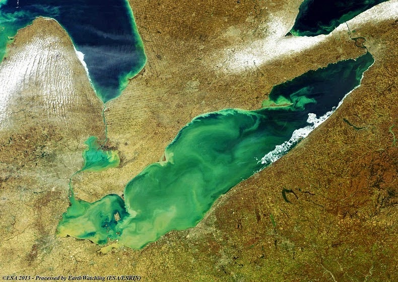
During the summer months, Lake Erie along with the rest of the five Great Lakes smothers under massive swaths of green algae, often spread over thousands of square kilometers in size. The algae flourish by feeding on excess nutrients in the form of phosphorous in the water. The phosphorus comes from sewage treatment plants and fertilizer used in farms that runoff along with rain water and enters into streams and rivers ultimately winding up in Lake Erie. Blue-green algae also prosper on light. Lake Erie, being the shallowest of the Great Lakes, particularly at its west end, is further susceptible to algae than its deeper cousins, which do not have the same penetration of sunlight. The algae float on the surface and proliferate rapidly, and when they die, they sink to the bottom of the lake, where they falloff and absorb the oxygen in the water creating dead zones where most aquatic animals cannot live. Hundreds of thousands of dead fish washed up on Erie’s shores during 2011 when the lake saw the biggest algae bloom in recorded history. The blue-green algae occupied Lake Erie covering as much as one/sixth of the surface, ranging from Toledo, Ohio to beyond Cleveland and along the Ontario shore. It stretched over 20 KM from the shores, and in the central basin it was observed at a depth of at least 60 feet.
Not all types of algae are destructive, but the bloom is primarily microcytic aeruginosa, algae that is toxic to mammals. Microcystis aeruginosa produces a liver toxin, microcystin, that commonly kills dogs swimming in infected water and causes skin irritation, respiratory difficulty and gastrointestinal distress in humans. However; algae blooms were common in the lake’s shallow western basin in the 1950’s and 60’s. Phosphorus from farms, sewage, and industry fertilized the waters so that massive algae blooms developed year after year. The blooms subsided a bit starting in the 1970,s when regulations and developments in agriculture and sewage treatment restricted the amount of phosphorus that reached the lake. But the problem has resurfaced in the recent years.Source: Amusing Planet

Gypsum Lakes or Birridas of Shark Bay


The Shark Bay or Birridas of Shark Bay is having outstanding natural features and a world Heritage site, the most westerly point of the Australian continent, next to the Indian. Scattered around Shark Bay, especially within Peron Peninsula inside the Francois Peron National Park, are a number of saline lakes of gypsum, famous among local’s peoples is “Birridas”.
It is believed thousands of years ago, when the sea levels were much higher than they are today, birridas were landlocked saline lakes among sand dunes. The water was so rich in sulphate of lime that was deposited onto the lake floor. But with the passage of time when the sea level dropped, the lakes dried up gradually and creating salty hollows and the sulphate of lime evaporated and became loose, powdery gypsum. The shape of Birridas is circular or oval and range from 100 m to 1 kilometer wide. They normally comprise of a central, raised platform ringed by a moat-like depression. The central section corresponds to the level of the water table during the late Pleistocene Period, about 10 000 years ago. Today, during very high winter tides or after heavy rains, when the groundwater level is raised, these moats fill with water to a shallow level.
Most birridas retain water for more than a few months following rain, and at those times, dormant eggs hatch and the birridas teem with brine shrimp, horse-shoe crabs and other invertebrates. They deliver a feast for wading birds such as red-necked stints and bar-tailed godwits that have migrated to Shark Bay from as far away as Siberia. Various birridas are connected to the sea by channels and receive seawater as well, where they form shallow bays. These bays are extremely imperative for fish breeding and nursery areas, although most birridas at Shark Bay are isolated, but are common in Francois Peron National Park where there are over 100 on the east coast of the Peron Peninsula. You can see birridas when driving around the park, however to appreciate the shapes and sheer number of birridas it is paramount to take a flight.

Peculiar Tree in the Rock of Wyoming


This is a peculiar tree and located right in the middle of Interstate 80, between Cheyenne and Laramie, in southeast Wyoming. The tree actually is a limber pine, which is common to the area, but this one seems to be growing out of a solid granite boulder. You will observe upon closer inspection, that it’s really growing out of a crack in the rock, owing to which the tree is stunted and twisted but is still going strong. This trivial tree has spellbound the travelers since the first train rolled past on the Union Pacific Railroad. It is believed that the builders of the original railroad diverted the tracks somewhat to pass by the tree as they laid rails across the Sherman Mountains in 1867-69. The train used to stop here while the locomotive firemen "gave the tree a drink" from their water buckets. The railroad moved numerous miles to the South in 1901 and the abandoned grade became a wagon road. Then in 1913, the old Lincoln Highway came by the Tree Rock, and by the 1920′s, the Lincoln Highway gave way to U.S. Highway 30. Lastly, in the 1960′s, Interstate 80 was built, and Tree Rock was assured a large audience for years to come. The tree is now surrounded by a spiky fence to keep it, and a little parking area is close for travelers to stop and take pictures. No one knows exactly how old the tree is, but Limber Pines can live as long as 2000 years.

Kaali Meteorite Crater of Estonia


The Kaali Meteorite Crater is situated in the village of Kaali on the Estonian island of Saaremaa, almost 18 kilometers from its capital Kuressaare. It is believed it was last gigantic meteorite to fall into a densely inhabited area, and the scar it left on the landscape expresses about the dreadful events which happened here during the Bronze Age.
Some 7,600 years ago, a huge rock, between 20 to 80 tons in mass, ripped through Earth’s atmosphere at a velocity in the middle of 10 to 20 km/s, with an an altitude of 5 to 10 kilometer, the meteorite broke up into countless pieces and fell in fragments. The biggest of them slammed into the earth releasing energy comparable to approximately 20 kilotons of TNT, or 25% more potent than the atomic bomb that leveled Hiroshima during the end of the World War II. The explosion removed about 81,000 cubic meters of dolomites and other rock, shaped a fireball 7 to 8 kilometers tall and incinerated forests within a 6 kilometers radius.
During that time, village was forested with a little human population and impact was less damaged. Perhaps casualties must have been several, but the exploding meteor left a whole of nine craters in an area which is now recognized as the Kaali Meteorite Crater Field. The main of these craters has a diameter of 110 meters and a depth of 22 meters. Other pieces of meteorite shaped smaller craters with diameters ranging from 12-40 meters and their relevant depths vary from one to four meters. All lie within a distance of one kilometer from the main crater.
These days Kaali Crater has a lake in it, mainly fed by ground water and precipitation, it is mainly depending on the time of year and this lake has a diameter of 30-60 meters and depth of 1-6 meters. The surrounding of Kaali crater are the remains of a huge stone wall 470 meters long, 2.5 meters thick and around 2 meters high, believed built during the early Iron Age (600B.C. to 100A.D.)  A massive number of domestic animal bones have been found inside the walled area, the newest dating to the 17th century, signifying that the lake was not only used as a watering hole but as a place for ritual sacrifices. Moreover; there are indication of a fortified settlement inhabited from the 5th to 7th century BC and a slight hoard of silver jewelry from the 3rd to 5th centuries AD.
The wall, the silver and the bones have led to gossip that century after the catastrophic explosion took place, the crater took on the role of a pagan worship site. The Estonians are recognized to have made animal offerings to certify good harvests, which persistent to be made in secret long after the Church forbade such pagan practices. Stories of the catastrophe and the lake appear prominently in Finnish mythology, particularly the national epic, Kalevala which give a very truthful description of fire falling from the sky that burned houses, fields, fens and humans.