Wednesday, 26 March 2014

Heaven Lake China & North Korea


The beautiful Heaven Lake is actually a crater lake situated on the border between China and North Korea. It lies within a caldera atop the volcanic Baekdu Mountain, created by a major eruption in 969 AD.  Heaven Lake is like crescent shaped water area deserves its name pearl of Heavenly Mountain with melted snow as its source, containing crystal water, and ideal place in summer. The lake is very peaceful and magical and tourists can go for strolls on the mountain paths and the more athletic can hike or ride a horse up to the glacier plains where the scenery is simply stunning.
Heaven Lake has a surface elevation of 7,182 ft, and covers an area of 9.82 km2 with a south-north length of 4.85 kilometers and east-west length of 3.35 kilometers. The average depth of the lake is 699 ft and maximum depth of 1,260 ft. From mid-October to mid-June, it is typically covered with ice. In North Korean legend, Kim Jong-il is claimed to have been born near the lake on the mountain. Upon his death, the Korean Central News Agency claimed that the ice on the lake cracked "so loud, it seemed to shake the Heavens and the Earth. Heaven Lake is also alleged to be home to the Lake Tianchi Monster.


Lake Balapan, (Atomic Lake or Lake Chagan) Kazakhstan


During the hey days of Cold War, the Soviet started blowing up nukes all over northeastern Kazakhstan to examine the possibility of using nuclear power for peaceful construction purposes such as moving earth, creating canals and reservoirs, drilling for oil and so on. The tests were carried out under the banner of “Nuclear Explosions for the National Economy”. This was the Soviet version of “Operation Plowshare” a related program devised by the United States. Having borrowed the dreadful idea from the United States, the Soviet program got started in potency and ended up being many times larger than the United States. Plowshare program both in terms of the number of applications explored with field experiments and the extent to which they were introduced into industrial use. While the United States conducted twenty seven (27) tests before understanding it was a not a good idea and dismissed the program in 1977, but the Soviets was persistent at right up to 1989 during which as many as 156 nuclear tests were conducted.
But, no one can swims in Lake Chagan anymore, even the fish are gone from there too, as are birds and any other animal. Lake Chagan is cannot be found there either, just an Atomic Lake. The water in Atomic Lake is dangerously radioactive. And fish cannot survive in it, and even there are no wild animals or birds along its shore. The lake regularly emits a foul odor, and there is also growing evidence that the Lake’s water is seeping into the nearby Irtysh River, which flows into Siberia and into the Kara Sea, which then would flow into the Arctic Ocean.
One of the better known tests is the January 1965 test at Chagan, on the edge of the Semipalatinsk Test Site in Kazakhstan. The Chagan test was designed to test the appropriateness of nuclear explosions for creating reservoirs. It was the first and largest of all detonations carried in the Nuclear Explosions for the National Economy program. A massive 140 kiloton device was fixed in a 178 meter deep hole in the dry bed of the Chagan River so that the crater lip would dam up the river during periods of high flow. The blast shaped a crater 400 meters across and 100 meters deep with a lip height of 20-38 meters. Later on, a channel was cut into the crater letting it, and the reservoir behind it, to fill up with water.
The reservoir recognized informally as Lake Chagan, and still exists nowadays in substantially the identical form. The water continues to be radioactive and near hundred times more than the permitted level of radionuclides in drinking water, however 100 to 150 meters away dose levels were at background level. At that time of its creation, the Soviet government was thrilled of Lake Chagan. Even though they’ve made a film with the Minister of the Medium Machine Building Ministry, the one accountable for the whole Soviet nuclear weapons program, taking a swim in the Crater Lake and water from it was used to feed cattle in the area.
It was projected that some 20% of the radioactive products from the Chagan test get away the blast zone, and were spotted over Japan. This was really infuriated the United States for violating the provisions of the October 1963 Limited Test Ban Treaty, which banned atmospheric tests. Whereas Soviets replied that it was an underground test and the quantity of radioactive debris that gets away into the atmosphere was insignificant. After numerous subsequent interactions, the matter was finally abandoned.


Monday, 24 March 2014

Cares Gorge Trail Adventure is one of the Most Beautiful Hikes in Spain


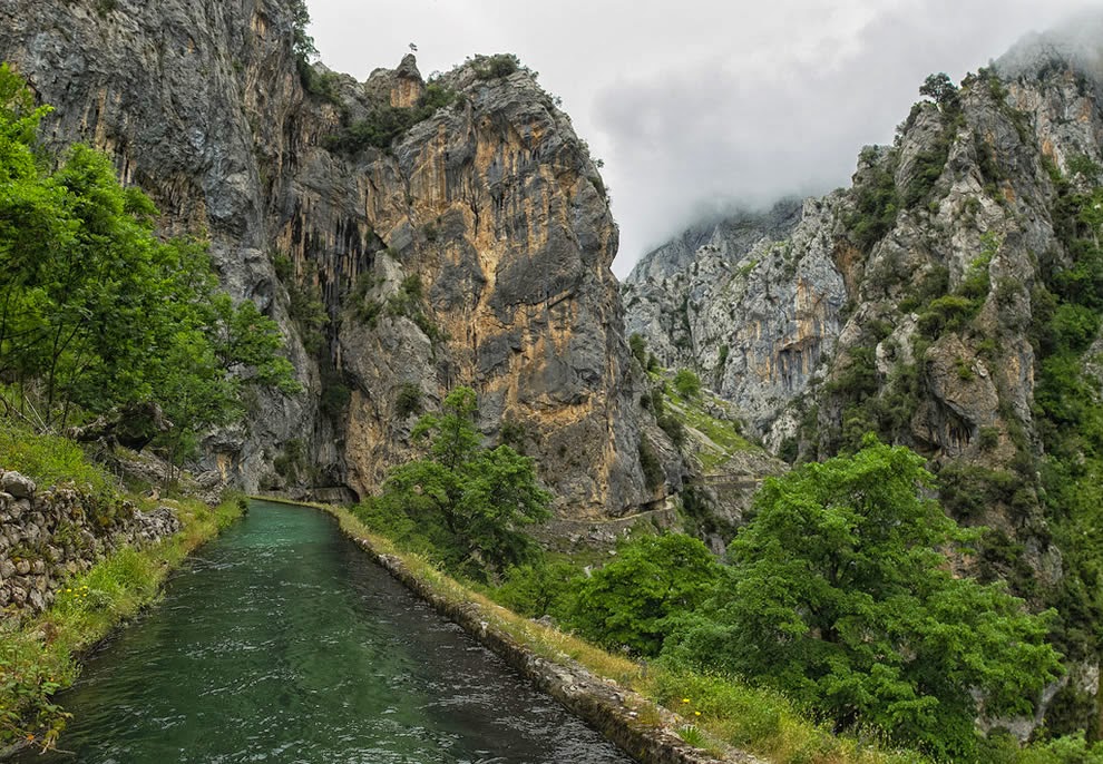
An adventure waits of hikers at the heart of Picos de Europa National Park in northern Spain. The hiking trail consists of nine miles along the Cares River and the Cares Gorge, aka “divine gorge”. Steep cliffs stretch up over 6,500 feet on one side and the Cares River is as far as 650 feet below in the deep gorge. The Cares Gorge trail is tremendously popular because it is considered one of the most striking walks in all of Spain. The footpath was well improved about sixty years ago when tunnels were carved into the mountain to serve as a maintenance trail to a hydroelectric power station. Long time ago some particular sections of the path were used by shepherds, sheep and even goats.
In the snowy seasons this route providing the only communication between two villages. The Picos de Europa national park was also named a biosphere reserve by UNESCO. Whenever you visit Spain, it is highly recommended to reserve a day to trek this beautiful trail. Cares Chanel narrow pathways carved into stone to observe one of the most attractive hiking adventures in Spain. The trail gets pretty crowded at weekends and in high season, although it is emptier around lunchtime go mid-week if you can. Animals you may see include goats and huge vultures soaring high above the spikes.
The Cares Gorge is massive outstanding lovely in its upper reaches, and unmissable if you are anywhere near the Picos de Europa. The river has been somewhat diverted for hydroelectric power, water coursing down a canal built into the mountain itself, and walkers can use the related maintenance path. This is an inspiring feat of engineering, clinging to the cliff face and tunneling through live rock. Though the track is wide and easy, and perhaps it’s not the best place for sufferers from vertigo. The lower gorge is enormous and grand, the path winding perhaps a thousand feet above the river after an ascent from the perfect Roman Bridge with magnificent swimming-pool beneath it near Poncebos. You get big views along the gorge from ridge tops, where you want to sit and marvel.
On the southern side it is massive Murallon de Amuesa wall. The river is a little glistening thread from here. Around the great bend, the upper south-north gorge is more attractive, greener and more enclosed. Between cliffs and crags, thinly forested couloirs soar for hundreds of meters to the dreadfully distant peaks framed between their walls. The deep recesses of the gorge hardly ever see the light and harbor a dank, ferny microclimate. It is extremely difficult to do fairness to the drama of the path as it winds, hundreds of sheer feet above the river, around the smooth walls of the gorge, at times dipping through arches or longer galleries. As you approach Cain, you will cross the gorge twice on spectacular bridges, and pass through a series of galleries. Some people descend the gorge from Cain where the gorge-proper begins to Poncebos, although it is possible to start/finish at the villages higher up the Cares valley.
However, ascending the gorge is perhaps preferable. The gorge path from Poncebos to Cain is around 15 kilometers figures vary wildly and takes around three and half hours to walk but assume a lot of extra gawping time. Getting among the two road heads is difficult and takes two hours by taxi so some people walk both ways along the gorge, or walk in as far as their time and inclination permit them before turning back.


Sunday, 23 March 2014

Faisal Masjid Pakistan


The Faisal Masjid is the largest Masjid in Pakistan, situated in the national capital city of Islamabad. Faisal Mosque was completed in 1986 and this master piece was designed by Turkish architect Vedat Dalokay to be designed like a desert Bedouin's tent. It is located at the north end of Faisal Avenue, putting it at the northernmost end of the city and at the foot of Margalla Hills, the westernmost foothills of the Himalayas. The Faisal Mosque is named after the late King Faisal bin Abdul Aziz of Saudi Arabia, who actually supported and financed this project. Faisal Mosque is a popular Masjid in the Islamic world, and is famous for both its immense size and its architecture.
It is located on an elevated area of land against a picturesque backdrop of the Margalla Hills. This enviable location represents the Masjid's great importance and allows it to be seen from miles around day and night. It has a covered area of 54,000 sq ft and has a capacity to accommodate almost 300,000 worshippers about 100,000 in its main prayer hall, courtyard and porticoes and another 200,000 in its adjoining grounds. Each of the Mosque's four minarets are 260 ft high the tallest minarets in South Asia and measure 10 x 10 m in circumference.
The minarets borrow their design from Turkish tradition and are thin and pencil like. The interior of Faisal Masjid prayer hall holds a very large chandelier and its walls are beautifully decorated with mosaics and calligraphy by the famous Pakistani artist Sadequain. Moreover; the mosaic pattern decorates the west wall, and has the Kalmah written in early Kufic script, repeated in mirror image pattern.