A compendium of interesting places, hidden wonders, Beautiful Places, strange travel destination, tourist attractions.
Monday, 8 June 2020
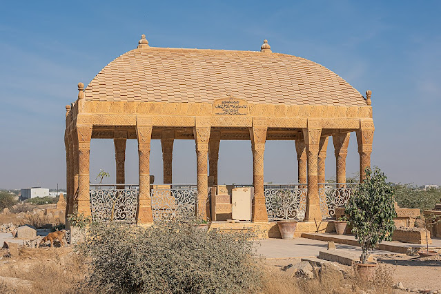
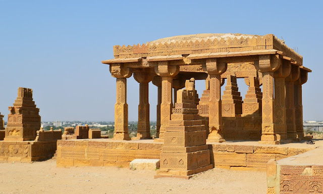
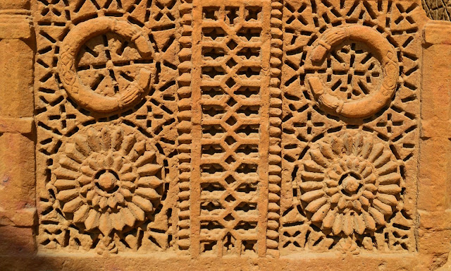
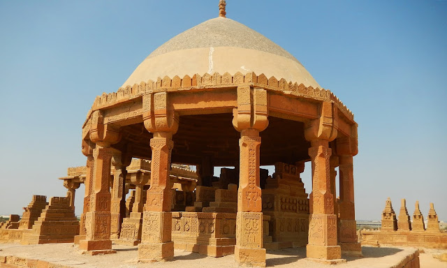
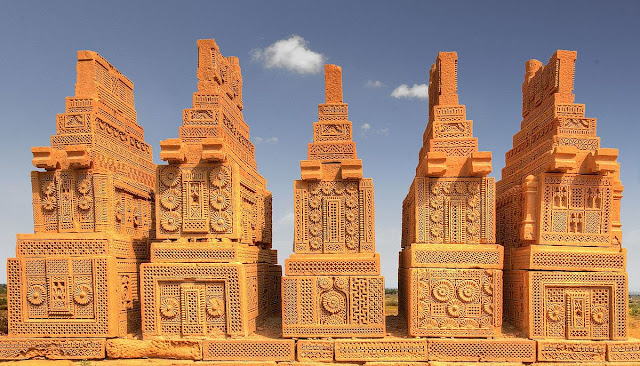
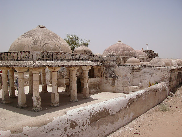
Chokundi Cemetery and Tombs - Pakistan
In Baluchistan and Sindh, this is a remarkable graveyard constructed with buff-colored sandstone. This type of graveyard well preserved in the arid condition, either single graves or groups of eight graved raised on a common platform.
Saturday, 6 June 2020
Brazil High Rise Vertical Cemetery
Do you know, there is the only city in the world with a 32-story cemetery, what is the real story behind
this unique work? The world's population is growing rapidly. Not only is there
a shortage of housing for the living, but it is also becoming increasingly
difficult to find a suitable eternal resting place after death.
The number of deaths in the
world is also increasing rapidly and it is time that there is no place to bury
in the cemetery. Peoples look the best place to bury their beloved ones.
However, finding space is really difficult in some of the world cities.
These days, high-rise
cemeteries are becoming rapidly popular around the world, and the Memorial
Necrópole Ecumênica, in Santos, Brazil, is the highest of them all. In some
societies, corpses are cremated and buried, while in the divine religions the
dead are buried. Graves and land are dwindling due to population growth.
To overcome this problem,
in some countries the practice of making cemeteries in the form of buildings
instead of ground cemeteries is on the rise. Due to the availability of land
for graves and the proportion of the population, construction of a high-rise
building began in 1983 in the Brazilian city of Santos, which has now become
the tallest cemetery in the world and is listed in the Guinness World Records.
This beautiful 32-story building at the foot of a mountain is 108 meters high. The building name is
Memorial Necropolis Echomanica. It also has a beautiful lawn, parking lot, a
church, a garden, a waterfall, and a restaurant. There are several blocks on 32
floors and each block has 150 tombs.
In addition, there are six
tombs in each storey. This lofty cemetery can accommodate 25,000 corpses at a
time. Here the bodies are kept on rent for three years and after three years
the remains are handed over to the heirs so that they can be buried or disposed
of elsewhere. There are proper ventilation arrangements to keep the graves
cool.
Moreover, the interesting fact is that the higher the tomb, the higher the price? The building has become a major tourist attraction in Brazil and millions of tourists come here to see the sights. However, the burial of corpses is becoming a serious problem for the living people living in the world because the world is just a cabin and we have to go to our final resting place anywhere. Death is inevitable, it is a hard fact of life to accept it, no matter it is easy or uncomfortable. Every human has to embrace death one day.
Product You May Interested
- Feel Emotional Freedom! Release Stress, Heal Your Heart, Master Your Mind
- 28 Day Keto Challenge
- Get Your Customs Keto Diet Plan
- A fascinating approach to wipe out anxiety disorders and cure in just weeks, to become Anxiety free, relaxed, and happy.
- Flavor Pairing Ritual Supercharges Women’s Metabolisms
- The best Keto Diet Program
- Boost Your Energy, Immune System, Sexual Function, Strength & Athletic Performance
- Find Luxury & Designer Goods, Handbags & Clothes at or Below Wholesale
- Unlock your Hip Flexors, Gives you More Strength, Better Health, and All-Day Energy.
- Cat Spraying No More – How to Stop Your Cat from Peeing Outside the Litter Box – Permanently.
- Anti-aging nutritional unexplained weight gain, stubborn belly fat, and metabolic slowdown. Reach Your Desired Weight in a Week and Stay There.
- Get All Your Healthy Superfoods In One Drink.
Wednesday, 3 June 2020
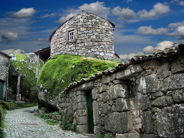
Monsanto Village Portugal
An enchanting and
lonely village of Monsanto is located at Southeast of Serra da Estrela in
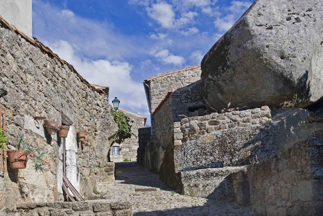
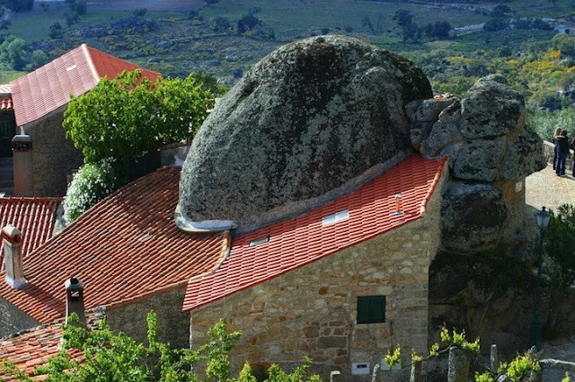
Portugal, perched on the side of a mountain. Monsanto village is built among
rocks, with squeezed homes between massive boulders, and small streets carved
through the rocks. The beauty of this village hasn't changed in several centuries.
It lies on an important strategic location defending from various invaders over
the centuries.
Few of the granite
houses have Manueline doorways and the wreck of a castle that started as a
Lusitanian fortified settlement, offering splendid views stretching as far as
Serra da Estrela. The mountain peak has actually been very important strategic
position since prehistoric times, crowned by remnants of Templar castle,
partially damaged by an explosion in the 19th century.
In the national contest of 1938 Monsanto village was dubbed "the most Portuguese village in Portugal". Therefore, since then building restrictions have allowed it to remain a living museum. It is not easy to reach Monsanto by public transportation, but its atmosphere and the immense panorama is worth a drive from the towns close by or Serra da Estrela.
A former civil
parish in the municipality of Idanha-a-Nova, covered an area of 131km. The
village is populating with the one thousand residents. The Monsanto historic village
is built upon in a fusion of nature and its landforms that can be seen in the
uses of caves and rocks being converted into construction parts. Monsanto
village has maintained its classics charms from many centuries.
Product You May Interested
- Feel Emotional Freedom! Release Stress, Heal Your Heart, Master Your Mind
- 28 Day Keto Challenge
- Get Your Customs Keto Diet Plan
- A fascinating approach to wipe out anxiety disorders and cure in just weeks, to become Anxiety free, relaxed, and happy.
- Flavor Pairing Ritual Supercharges Women’s Metabolisms
- The best Keto Diet Program
- Boost Your Energy, Immune System, Sexual Function, Strength & Athletic Performance
- Find Luxury & Designer Goods, Handbags & Clothes at or Below Wholesale
- Unlock your Hip Flexors, Gives you More Strength, Better Health, and All-Day Energy.
- Cat Spraying No More – How to Stop Your Cat from Peeing Outside the Litter Box – Permanently.
- Anti-aging nutritional unexplained weight gain, stubborn belly fat, and metabolic slowdown. Reach Your Desired Weight in a Week and Stay There.
- Get All Your Healthy Superfoods In One Drink
Sunday, 17 May 2020
Bhodesar - The ancient city of Nagarparker
Bhadrishar
Nagri, is now called Bhodesar, is located at the foot of the Karunjhar Hills,
two miles northwest of the city of Nagarparkar. The people living here were
followers of Jainism. After the formation of Pakistan, the followers of Jainism
migrated from here with their idols. Their monuments are still present in the
form of temples. Bhodesar is also commonly known as Bhodesar Nagra. It is also
known, due to which the area was named Nagar Parker.
The city of
Bhodesar was founded in 515 BC. According to the duo of Nokoti Marwar, Hansi
made Pari Nagar the capital of his government. His second brother was Bhodo. He
came and settled in Bhodesar. People belonging to the tribe were settled. The
Jenny people, who were quite wealthy, paid homage to Rana Bhodesar, the ruler
of Thar. About 600 BC, a man named Mahavira founded Jain Dharma.
Some scholars
say that Jains Doctrine is a branch of Hindu Dharma, while some scholars claim
that it is closer to Buddhism. One-third was peaceful people, who considered it
a sin to harm a living being. This was the reason why they used to walk
barefoot and with a cloth over their mouths and cook in the evening and did not
light lanterns, lamps or lamps for lighting in the houses so that no living the thing would be harmed by it
Some
historians also say that the area was named after the queen of the Indus
Valley, "Bhodi". She built a beautiful pond at the foot of the
Karunjhar hills, which gained historical significance due to Sultan Mahmud of
Ghazni. According to tradition, during the expedition of Somnath, Sultan Mahmud
Ghaznavi lost his way while passing through the Thar Desert and he wandered and
reached the hills of Karunjhar.
In a state of
extreme thirst, he and his army reached the pond in search of water, where he
and his soldiers quenched their thirst and stored water for his long journey.
He erected a monument here to commemorate the occasion.
In the 14th or
15th century AD, there was a lot of sodhas and khusos in Parker. The people of
the area were very narrow in their hands. He complained to the king of the
Tughlaq dynasty of India, who ordered Ran Mahmud Begra, the ruler of Gujarat,
to suppress him. Sultan Mahmood defeated these tribes by assassinating the army
but after his return to Gujarat they started revolting again. Therefore, he
attacked again and after restoring law and order in the city he returned to his
capital, Ahmedabad.
Sometime
later, Sultan Mehmood mother was passing by Bhodesar with a caravan when the
Sodhas stopped her caravan and received a bribe. When his mother reached
Ahmedabad, and told this story. Then in the third phase, in 1505, he attacked
Bhodisar. There was a fierce battle in which many of the Sultan's men were
killed And the Sodhas also suffered heavy casualties.
He settled the
Muslim soldiers of his army here and built the "Bhodisar Masjid"
which is located at the same place where Sultan Mahmud Ghaznavi had built a
monument. This magnificent mosque, thirty feet long and twenty feet wide, is an
eternal masterpiece of the architectural art of the followers of Islam.
In the
construction, large marble stones have been used in all the walls and floors,
which are placed on top of each other in such a way that it looks as if someone
has placed them today. The three domes and mahrabs of the mosque are
beautifully constructed from the stones brought from the Karunjhar hills.
The color of
the ancient civilization of Mehran Valley is also in the structure of the
historic Bhodisar Masjid located at the foot of the magical mountains of
Karunjhar. Hlkta is visible.
Further, it is
said that the craftsmen of Jain Dharma took part in the construction of this
mosque at that time by setting the best example of religious tolerance. This
mosque consisting of marble pillars is its own example. In the vast courtyard
of the mosque is a historic cemetery with stone tombs belonging to the soldiers
of Mahmud Hegray who were martyred in the battle with the Khushos.
Despite the
passage of many centuries, this ancient mosque still retains its existence.
Yes, but due to the inattention of the government, the historical heritage had
started losing its identity and the walls of the mosque were slowly crumbling. Thus,
due to government ignorance, this historic mosque was in a dilapidated
condition for a long time.
Minister for
Tourism Syed Sardar Ali Shah visited Bhodesar Mosque along with other
antiquities in Nagarpakar Has been repaired and painted, which has once again
brightened the shape of the mosque. Every year during the rainy season,
thousands of tourists flock to Bhodesar, the city of Nagarpakar, to see the
Bhodesar Mosque, and capture in their cameras.
The memorable
impressions of historical monuments built hundreds of years ago. The beautiful pond is in the form of a lake which fills up after rains and the water stays
there all year-round and in the winter season exotic birds also come and
camp here but due to lack of rain for the last two years, it looks empty.
The author of
the book Old Parker, Magha Ram Ojha, is of the opinion that Sultan Mehmood
Ghaznavi has been staying near this pond for two days and the battle between
Mahmud Shah Hegray and the Sodhas also took place near this pond.
Due to the
desolation of this pond it has also been called a pool of ghosts and people are
afraid to pass by it. In order to save this ancient monument, water can be
arranged in it and it can be turned into a beautiful lake and made a tourist
destination.
In the evening, the bells of the herds of cattle returning from the middle of the Karunjhar Mountain and the sounds of the "walking" of the herdsmen are mesmerizing. The conditions of the region can be changed and thus the arrival of tourists can bring back the heights of this region rich in natural blessings.
Wednesday, 13 May 2020
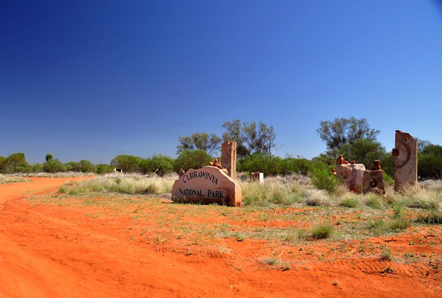
Currawinya National Park, Queensland, Australia
Two vast lakes — Wyara and Numalla — are the centerpiece of 154,870 ha Currawinya National Park, but they are not the only reasons to visit. Currawinya is rich in nature and cultural heritage. Visitors can bird watch, fish, or enjoy the solitude of camping beside the Paroo River.
Access
Near Hungerford on the Queensland/New South Wales border, all access roads to Currawinya are unsealed and impassable when wet. A 4WD vehicle is recommended.
From Cunnamulla, drive 70 km south-west to Eulo, then a further 4 km west before turning south towards Hungerford. The final 97 km to the park office takes 1 to 1.5 hours to drive.
From the south, enter the park via Hungerford, 217 km north-west of Bourke. The park office is 20 km north of Hungerford. Access is via working pastoral properties. Take care to avoid stock on unfenced roads and leave gates as you find them.
Hence, respect the rights of property owners. After good rains (either locally or far upstream) flooding isolates the park for long periods and can submerge campsites along the Paroo River. Therefore, you need to check conditions before traveling and always carry extra supplies in case of stranding. The nearest fuel and supplies are located at Cunnamulla and Thargomindah.
Camping
Bush camp at Ourimperee Waterhole is behind the Woolshed (close to flushing toilets and a bush shower), or at sites on the Paroo River near Caiwarro at the park’s northern end.
Currawinya’s Lakes
Currawinya National Park is a wetland of international importance under the Ramsar Convention. Currawinya’s lakes are important breeding and refuge sites for a spectacular array of water birds, including waders migrating from across Australia and the world.
Currawinya’s wetlands regularly support up to 100 000 water birds. Of particular importance are lakes Numalla and Wyara — no other wetland complex in arid or southern Australia is thought to consistently support such large populations of water birds.
Separated by only a few kilometers of sand dunes, each has different water conditions. Lake Numalla receives floodwaters more frequently from the Paroo River and is usually permanent. It holds freshwater, while the slightly larger Lake Wyara is saline and regularly dries to a vast, white clay pan.
Different bird communities live on each of the lakes at different times. Lake Wyara supports a greater number of water birds while Lake Numalla has a greater diversity. Smaller waders and plant-eating water birds feed in the clear, salty waters of Lake Wyara, which has more aquatic vegetation and invertebrates.
Shallows are the home to sandpipers, godwits, snipes, rails, dotterels, and stilts. At times thousands of black swans, coots, and grebes can be seen; as can ducks—including Pink-eared, hardhead, black and wood ducks, and the rare freckled duck. Lake Wyara provides a safe breeding ground for red-necked avocets, silver gulls, Caspian terns, cormorants, black swans, Australian pelicans, and many other species.
Pelicans that breed at Lake Wyara often fly to Lake Numalla and other surrounding lakes (including Lake Bindegolly 80 km away) to feed. Large waders and fish-eating species prefer the turbid (muddy) waters of Lake Numalla. Egrets, herons, cormorants, ibis, plovers, and brogans are most common. When seasonal waterholes, lakes, and clay pans fill after good rains, water birds scatter across the park. Spoonbills, great egrets, and straw-necked ibis can be seen.
Keeping Watch on Currawinya’s Birds
Researchers from the University of Newcastle and rangers have been studying the effects of the changing water levels and conditions of birds in these outback lakes. When water levels are low, lake water can be 10 times as salty as seawater, yet when full the water can be quite fresh.
High plankton levels lead to an influx of filter-feeding birds such as Pink-eared ducks. During drought, more than 10 000 freckled ducks have been seen. Researchers have also been studying breeding colonies of pelicans and other bird species.
Moreover, a study of Lake Yumberarra, a smaller lake that is fresh or salty depending on the season, has recorded 58 of Currawinya’s known waterbird species. It has more species than the larger lakes.
Things to Do
Learn about the park - Visit the information display at the turnoff to the park office.
Drive to the Lakes
See some of inland Australia’s most important wetlands and the variety of mulga lands’ habitats along the way. A 4WD vehicle is needed for the 85 km round trip from the park office to lakes Wyara and Numalla. The road may be closed after rain.
Walk to the Granites
Take the Boorara Road for 10 km north of Ten Mile Bore where a short walk leads to a small granite outcrop. Views from atop the outcrop extend over the park. Walk carefully—the track is uneven and rocks may be slippery. Carry drinking water.
Value Heritage
Currawinya has a large number of sites significant to Aboriginal people. These and any associated artifacts are protected by law—please respect this and leave areas and artifacts as you find them.
Lakes and waterholes are of particular importance to the Traditional People of this area and those from neighboring areas, especially as gathering places during the waterbird breeding season. Heritage enthusiasts should visit the old Caiwarro homestead site, 37 km north of the park office.
Bulldozed prior to the pastoral property becoming a national park, the remains of several buildings, including a levee bank and machinery can still be seen. Please take care near ruins and treat such reminders of our pastoral history with respect. Visit Hungerford where the historic Royal Mail Hotel, built-in 1870, still operates.
Boating and Fishing
Fishing is permitted along the Paroo River and in selected areas of Lake Numalla. See the ranger or on-site signs for details. Only live bait caught within the Paroo River system can be brought into the park.
Canoeing, kayaking, and swimming are permitted on Lake Numalla; however motorized boats and jet skis are not permitted on any of the lakes. Signs at lakes Wyara and Numalla show the activities permitted in particular areas.
Along the Paroo River
This 600 kilometer-Long River has a catchment of over 70000 square kilometers and is the last free-flowing river in the Murray–Darling Basin. In wet times it forms a floodplain of over 800 000 ha. In the dry season, the river becomes a string of waterholes such as Ourimperee and Corni Paroo waterholes in Currawinya National Park.
Wildlife Watching
The variety of landscapes and permanent water make Currawinya rich in wildlife. Kangaroos, wallaroos, and emus are readily seen. Reptiles are plentiful, as are birds of prey. Currawinya is home to more than 200 species of birds. Spot Major Mitchell’s cockatoos, mulga parrots, Chestnut-crowned babblers, orange chats, White-plumed honeyeaters, and splendid fairy-wrens.
Along the river, look for water rats hunting small animals in the early morning and evening. During the day whistling kites dive into the water to scoop up fish while rufous night-herons roost on shady branches nearby. After dark, little pied bats skim for insects just above the water surface.
Currawinya also has a small population of the greater bilby. Captive-bred bilbies have been reintroduced to Currawinya inside a 25 square kilometer predator and feral animal-proof enclosure funded by public donations and built with the assistance of volunteers. Visitors to Currawinya cannot visit the bilby fence or see bilbies, but can learn about them and the re-introduction project from a display near the woolshed.
Exploring the Landscape
Lake Wyara is lined by salt-tolerant samphire plants, whereas black box, river cooba and boobialla border Lake Numalla and many, smaller temporary lakes. Channels and floodplains of the Paroo River and other creeks are fringed with yapunyah, coolibah, and river red gum.
Elsewhere, mulga dominates the sandplains. Turkeybush Eremophilaspp has gradually replaced understorey grasses and is a subject of ongoing scientific research. The pungent aroma of gidgee fills the air before, during, and after rain. Poplar box, beefwood, emu apple, leopardwood, and whitewood are common trees.
Uncommon and vital shrubs and trees include inland belah Casuarina cristata subsp. pauper, Melaleuca densispicata, and black blue bush Maireana pyramidata. Low-lying eroded dune fields are dominated by shrublands of turpentine and hop bush; whereas ‘Bastard’ mulga and lancewood grow on Hoods Range in the park’s north.
Product You May Interested
- Feel Emotional Freedom! Release Stress, Heal Your Heart, Master Your Mind
- 28 Day Keto Challenge
- Get Your Customs Keto Diet Plan
- A fascinating approach to wipe out anxiety disorders and cure in just weeks, to become Anxiety free, relaxed, and happy.
- Flavor Pairing Ritual Supercharges Women’s Metabolisms
- The best Keto Diet Program
- Boost Your Energy, Immune System, Sexual Function, Strength & Athletic Performance
- Find Luxury & Designer Goods, Handbags & Clothes at or Below Wholesale
- Unlock your Hip Flexors, Gives you More Strength, Better Health, and All-Day Energy.
- Cat Spraying No More – How to Stop Your Cat from Peeing Outside the Litter Box – Permanently.
- Anti-aging nutritional unexplained weight gain, stubborn belly fat, and metabolic slowdown. Reach Your Desired Weight in a Week and Stay There.
- Get All Your Healthy Superfoods In One Drink

