Tuesday, 28 March 2017

Jeita Grotto, Wonderful Underground Caves in Lebanon


Jeita Grotto is actually a cave system stretches about 9 kilometers into the mountains 18km northeast of Beirut. Jeita Grotto is one of greatest natural wonders, discovered in 1836 by Reverend William Thomson; and opened as a tourist attraction in 1969. During civil war, the caves were used as an ammunition store, now interconnected, karstic limestone caves are situated in the Nahr al-Kalb valley within the locality of Jeita. Though inhabited in prehistoric times, the lower cave was not rediscovered until 1836 it can only be visited by boat since it channels an underground river that provides fresh drinking water to more than a million Lebanese. These lower caves are always explored by small boat and are closed when the flood levels rise too high. However, the extraordinary upper cavern stays open all year and is explored on foot or via a cable car. It has strategically positioned colored lights that showcase the stalactites and stalagmites in all their crystalline glory. Moreover, the upper galleries house the world's largest known stalactites are composed of a series of chambers the largest of which peaks at a height of 390 feet.


The Lebanese speleologists discovered the upper galleries 60 metres above the lower cave in 1958. This has been accommodated with an access tunnel and a series of walkways to enable tourist’s safe access without disturbing the natural landscape. In spite of all kinds of tatty side attractions the site remains a spectacular day trip from Beirut, but keeps in mind that there’s no photography allowed. Geita Grotto is Lebanese national symbol and most famous tourist spot, plays an imperative role in social, economic and cultural player in the country. Geita Grotto was one of top 14 finalists in the New 7 Wonders of Nature competition.

 The Jeita caves are solutional karst caves, formed more than millions of years due to the dissolution of limestone, dissolved by carbonic acid charged rain water and groundwater. Thus, when the limestone, were originally waterproof, contains cracks produced by tectonic forces the water oozes into the rock and starts to widen the cracks and solute caves inside the layers Jeita is the longest cave complex in the Middle East geologically, the caves provide a tunnel or escape route for the underground river, which is the principal source of Nahr al-Kalb.

The Jeita grotto is the longest explored cave in Lebanon, hosts approximately 280,000 visitors per year. Moreover, the Jeita cave emits a spring with a flow ranging from 1–2 m3/s, providing fresh drinking water for one-and-a-half million inhabitants of the capital, Beirut. However, water pollution, due to domestic and agricultural runoff, remains a serious concern as recent analysis detected an increasing presence of coliform bacteria.

The name of the cave changed many times since its discovery. Initially it is called as Grottoes of Nahr al-Kalb, also known as Djaita, Jehita, and finally Jeita meaning “roaring water”. Nahr al-Kalb is the name of the river that runs through the grottoes. The Jeita grotto contains a lot of touristic attractions that fill the visitor’s time with enjoyment and happiness. The main attractions include ropeways, train, miniature zoo, gardens and many sculptures.


Mount Roraima, Oldest Geological Formations on Earth


Mount Roraima is also known as Tepuy Roraima and Cerro Roraima; is the highest of the Pakaraima chain of tepui plateaus in South America. A mystic, flat-topped mountain on the Venezuela-Brazil border that mystified 19th-century explorers and inspired “The Lost World” novel is enticing ever more modern-day adventurers. In 1595, English explorer Sir Walter Raleigh first described during his expedition. Once impenetrable to all but the Pemon indigenous people, thousands of hikers a year now make the trek across savannah, through rivers, under a waterfall and along a narrow path scaling the cliffs of Mount Roraima. Its 31 km2 summit area is bounded on all sides by cliffs rising 400 metres. The mountain also serves as the triple border point of Venezuela (85% of its territory), Guyana (10%) and Brazil (5%). The throngs are a boon to Venezuela's tottering tourism industry; they also scatter a prehistoric landscape with unwanted litter and strain a delicate ecosystem. Mount Roraima lies on the Guiana Shield in the southeastern corner of Venezuela's forming the highest peak of Guyana's Highland Range. Mount Roraima Top Park is considered some of the oldest geological formations on Earth, as much as two billion years ago in the Precambrian. It's an exotic, faraway destination so it's both very costly and very attractive, have the peaceful aura appropriate to one of the Earth's most ancient formations.

Although the steep sides of the plateau make it difficult to access, it was the first recorded major tepui to be climbed: Sir Everard im Thurn walked up a forested ramp in December 1884 to scale the plateau. This is the same route hikers take nowadays. The only non-technical route to the top is the Paraitepui route from Venezuela; any other approach will involve climbing gear. The highest point in Guyana and the highest point of the Brazilian state of Roraima lie on the plateau, but Venezuela and Brazil have higher mountains elsewhere. Mount Roraima, a natural border between three South American countries, offer such breathtaking views that they might just stick with you forever and ever down in some rusty memory box. This spot is about unconventional traveling ideas, a place where people can find unworldly landscapes and a new way of seeing things. And this is definitely one of them. Moreover, almost daily rains have also created an exclusive ecosystem which includes a number of endemic species, black frogs, dragonflies, tarantulas and such as a unique carnivorous pitcher plant, clinging to cracks and crevasses and some of the highest waterfalls in the world.

Mount Roraima was considered a symbol of these regions, an “axis mundi”, a massive tree within which all the vegetables and fruits of the world grow, tall cliff a place of mystery, myths for indigenous people used to live here from many centuries. Though, hiking is not hard here, can seek help from local peoples against some money. Mount Roraima is said to have some of the most captivating hiking trails in the world. This remote landscape of jungle and cliffs has inspired the dinosaur infested landscapes of Sir Arthur Conan Doyle’s novel The Lost World, and the dramatic waterfalls dubbed “Paradise Falls” in the 2009 Pixar film Up. As the time progresses, Mount Roraima is getting popular among tourist, an average 3,000 and 4,000 people are climbing each year, up from hundreds a few years ago. That makes queues during peak times, and sometimes leaves the few sheltered coves at the top crammed with tents. On Mount Roraima's vast plateau strange & gnarled rocks formed when the African and American continents scraped apart, play with the mind, humorous in the sun, ghostly in the mist.


Monday, 27 March 2017

Victoria Falls, One of Seven Wonders of the World


Victoria Falls, or Mosi-oa-Tunya is a waterfall in southern Africa on the Zambezi River at the border of Zambia and Zimbabwe. CNN has been described as one of the Seven Natural Wonders of the world. The Victoria Falls also known as “The Smoke That Thunders” continues in common usage as well. The World Heritage List officially recognizes both names. The legendary waterfall is among the most impressive & awe-inspiring to be found anywhere on the planet earth. David Livingstone, the Scottish missionary and explorer, is believed to have been the first European to view Victoria Falls on 16 November 1855, named his discovery in honor of Queen Victoria of Britain. The Victoria Falls generates mists sustain a rain forest-like ecosystem nearby the falls and on the opposite cliff that faces them like a dried-up mirror image, thick with mahogany, fig, palm, and other species of vegetation. The whole volume of the Zambezi River pours through the as much as six Gorge's zigzagging series of gorges designated by the order in which the river reaches them. Moreover, the geological history of Victoria Falls can be seen in the form of the gorges below the falls. The basalt plateau over which the Upper Zambezi flows has several large cracks filled with weaker sandstone. In the area of the present fall the largest cracks run unevenly east to west, with smaller north-south cracks connecting them. Thus, more than 100,000 years, the falls have been receding upstream through the Batoka Gorges, eroding the sandstone-filled cracks to form the gorges.

The Zambezi River is more than 2 km wide when it cascades over the lip of a large basalt plateau and plunges as much as 354 feet. The flow has been slicing gradually through this plateau for some two million years. During this time the river has slowly retreated and the leftovers of earlier, ancient falls can be seen in the gorges downstream from the current cataract. These days more than a few hundred thousand visitors from around the world trek to the falls each year; numerous hotels, restaurants, campgrounds, and other tourist businesses cater to them. The natural beauty of the falls lies in their natural state, but the area is at some risk of runaway tourism-based development as increasing resorts, hotels, and even a possible dam below the falls that could flood several park gorges. Moreover, operators in the area offer everything from helicopter overflights to bungee jumping, and the management of these activities while preserving a quality visitor experience for all is an ongoing challenge. Most visitors visit from either Victoria Falls (Zimbabwe) or Maramba (Zambia), where complete tourist facilities exist. Each town is accessible by road, rail, and air.

It is recommended to visit the area in February and March, when the river is typically in full flood. In that period as much as 540 million cubic meters of water fall over the edge every single minute. Moreover in the rainy season, the spray plume can obscure the view of the falls themselves. However at the end of November, when the water is at low ebb, visitors may see the curtain split into many smaller channels of falling water. The incredible falls are massive and invite contemplation from various different viewpoints. The trails offer you to walk around the area and relish vistas. Moreover, rare views are also to be had from the Knife Edge Bridge and Victoria Falls Bridge. Thus, River-level views from below the falls are a good way to experience their power up-close. At certain times of the year the daring may even swim in pools on the very crest of the cataract. Victoria Falls has more Zimbabwean and Zambian visitors than international tourists; the attraction is accessible by bus and train, and is therefore comparatively inexpensive to reach. Both countries permit tourists to make day trips across the border to view the falls from both viewpoints. A famous feature is the naturally formed "Armchair" also called "Devil's Pool", near the edge of the falls on Livingstone Island on the Zambian side.


Tuesday, 21 March 2017

The Catacombs of Kom El Shoqafa, Alexandria Egypt


The catacombs of Kom Kom El Shoqafa actually a historical archaeological site located, just to the west of Pompy's Pillar, Alexandria in Egypt. The meaning of catacombs of Kom Kom El Shoqafa is “Mound of Shards” is considered one of the Seven Wonders of the Middle Ages. Kom El Shuqafa, The “hill of treasures” in the Arabic language, was unearthed by coincidence in the beginning of the 20th century. It is named, because the area used to comprise of mounds of shards of terra cotta, mainly resided of jars and objects made with clay. The objects were left by tombs visitors who bring food and other stuff for their consumption during the visit. When this area discovers, a heaps of broken plates founded, because they didn’t want to carry such items home from this place of death so they would break them. The city of Alexandria was originally established by Alexander the Great, the most famous Greek King and army leader, in 332 BC and soon became the cultural and commercial center of the Mediterranean Sea region.
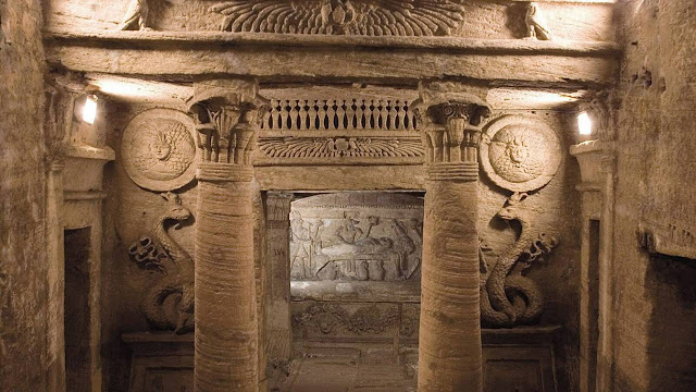
The necropolis comprises of a series of Alexandrian tombs, statues and archaeological objects of the Pharaonic funeral cult with Hellenistic and early Imperial Roman influences. As the time passes, several features of catacomsb of Kom El Shoqafa, merge Greek, Roman and Egyptian cultural points. The Catacombs features includes a Hall of Caracella, comprises of bones of young Christian men massacred by order of the emperor Caracalla in 215 AD. The Hall of Caracella also contains the bones of horses and humans were found A circular staircase, which was often used to transport deceased bodies down the middle of it, leads down into the tombs that were tunneled into the bedrock during the age of the Antonine emperors 2nd century AD, used as a burial chamber, before being rediscovered in 1900 when a donkey accidentally fell into the access shaft. So far, three sarcophagi have been found, along with other human and animal remnants. It is believed that the catacombs were only intended for a single family, but it is unclear why the site was expanded in order to house numerous other individuals.
The western side of catacombs comprises of three levels cut through solid rock, however, the third level being now entirely underwater. The catacombs have a six-pillared central shaft which opens off the vestibule. On the left is a triclinium, a funeral banquet hall where friends and family gathered on stone couches covered with cushions, both at the time of burial and also on future commemorative visits. Moreover, a stone staircase descends to the second level, an area spookily alive with sculptures. Further, in the building lobby, two pillars are topped by the papyrus, lotus, and acanthus leaves of ancient Egypt and two falcons flanking a winged sun adorn the frieze. Therefore, figures of a man and a woman are carved into the wall. There’re 3 huge stone coffins with non-removable covers along the sides of the chamber supposed that bodies were inserted in them from behind, using a passageway which runs around the outside of the funeral chamber. There is a hallway with 91" deep walls in the central tomb chamber, with carved recesses, each providing burial space for three mummies.


Monday, 20 March 2017

Halemaumau Crater, Kilauea in Hawaii


Halemaʻumaʻu Crater is a pit crater located close to caldera of Kīlauea in Hawaii Volcanoes National Park. The approximately circular crater floor is 770 meters x 900 m and is 83 m below the floor of Kīlauea caldera. Halemaʻumaʻu means "house of the `ama`u fern" is home to Pele, goddess of fire and volcanoes, according to the traditions of Hawaiian mythology. This place is burned like another planet with constantly changing scenery especially the view of Halemaumau crater at night is stunning. Pictures can't begin to capture how magnificent it is. The crater is presently active, encompassing a lava lake. The current vent inside Halemaʻumaʻu crater first erupted explosion on the night of April 9, 2008 that widened the hole by an additional 15 to 30 feet, ejected debris over some 200 ft and further damaged the overlook as well as scientific monitoring instruments.
The present lava inside the vent is changing from 20 to 150 meters below the crater floor. The molten lava in the vent, known as the Overlook Crater, became directly visible for the first time from the Jaggar Museum overlook at the Hawaiian Volcano Observatory; the lava started spilling over the rim of the Overlook Crater and onto the floor of Halemaʻumaʻu Crater, ultimately adding approximately 30 feet of fresh lava to the crater floor. The walls of the crater become destabilized by heating, weathering, earthquakes and loss of support. They fall into the lava causing degassing of the lava, the exsolution of gases happens rapidly, leading to the explosion. Usually, the lava within the lake is 100 feet to 200 feet below the rim, but recently the magma chamber that flows into the lava lake has shown increased inflation, suggesting that lava is being driven into the lake from an underground chamber below.

The lake level has since remained close to the rim, with an additional minor overflow event in October 2016. Therefore, early eruptions were recorded by oral history. One large eruption in 1790 killed several people, and left footprints in hardened ash of some Hawaiians killed by pyroclastic flows. However, the crater bottom was covered with lava, and the south-west and northern parts of it were one vast flood of burning matter, in a state of enormous ebullition, rolling to and fro its "fiery surge" and flaming billows.

The Crater Rim is not paved, so wear close-toed shoes with solid grip. Once you reach the overlook, you’ll be peering into the volcano goddess Pele's sanctuary. Though her flows are plunging into the ocean somewhere else, her home is in Halema'uma'u. Moreover, cultural ceremonies are held and offerings are sometimes left for her on the crater rim.  It was like gazing at the sun at noon-day, except that the glare was not quite so white. At uneven distances all around the shores of the lake were closely white-hot chimneys or hollow drums of lava, four or five feet high, and up through them were bursting stunning sprays of lava-gouts and gem spangles, some white, some red and some golden--a ceaseless bombardment, and one that fascinated the eye with its unapproachable splendor. The meager distant jets, sparkling up through an intervening gossamer veil of vapor, seemed miles away; and the further the curving ranks of fiery fountains receded, the more fairy-like and beautiful they appeared.


Friday, 17 March 2017

The Mysterious Big Circles of Jordan


Ancient stone rings in the desert have left archaeologists puzzled which is scattered across Jordan are 12 giant circular structures that can only be fully seen using aerial and satellite images. It is known as the Big Circles, range from between 720ft and 1,490ft in diameter were first spotted from the air in the 1920s. The big circles dates are not confirmed, but there is often material in or around the circles that originated in the Chalcolithic and Early Bronze Age (between 2,000 to 4,500BC). Moreover, a number of the circles contain later material, typically dating to the Roman period between 1st and 7th century BC.

It is also called “the vast rings” and eight big circles have been recorded in west central Jordan, between the Wadi el-Hasa and the edge of the Shara escarpment. There is a second group, made of four Big Circles just north of Azraq Oasis. Also, more Big Circle was spotted on satellite imagery in 2002 near Homs in Syria. The landscape of the Middle East is heavily strewn with circular or sub-circular stone-built structures, as most are crude circles, but numerous are clearly intended to be geometrically precise, although every so often slightly distorted typically consists of low walls of uncut boulders. Although precision of some of the circles, a swift task and would have involved around a dozen workers, perhaps an ‘architect’ would have plotted the circles using rope tied to a post in the center. Some show signs of greater care with stones at least roughly shaped and laid in courses. The circles would not have been hard to build, constructed mainly with local rocks, could potentially complete a Big Circle in a week. But the question is what was the purpose of construction big circles in a precise shape would have taken some planning. The architect could simply have tied a long rope to a post and walked in a circle, marking the ground as he or she moved around. That would also have some glitches in the circles where the land was uneven," as the architect wouldn't have been able to keep walking in a perfect circle at those spots.

Huge stone circles in the Middle East have been imaged from above, structures that have been shrouded in mystery for decades. The circles would have at first contained no openings or kinks, but a number now have routes passing through them, or contain ‘service gates.’ like circle J4, which lies 820ft east of the Desert Highway. This specific circle has five different features and seven breaks in the perimeter including drive gates, three service entrances, three drivers’ hides, seven ambush walls and two capture gates. The resemblances are ‘too close to be a coincidence but their purpose is unidentified. Thus, archaeologists need to excavate the sites to learn more about their construction and purpose. It seems unlikely that they were originally used as corrals, as the walls were no more than a few feet high, the circles contain no structures that would have helped maintain an animal herd and there's no need for animal corrals to have such a precise shape.