Monday, 14 April 2014

Tongariro National Park New Zealand

Tongariro Nationa Park is actually 4th established National Park in the world & oldest national park in New Zealand located in central North Island. This National Park encompasses three active volcanoes (Tongariro, Ruapehu, and Ngauruhoe) located at the southern end of a 2,500 kilometers long range of volcanoes. The National Park has two volcanoes on the northern end which erupted more than 20,000 years ago while one at Indo-Australian Plates meets the pacific plate, and has erupted due to internal tectonic processes, in the recent Aug 2012. These volcanoes have been together structure the mountains of Tongariro National Park for over two million years. Moreover; Ruapehu is world’s most active volcano & largest active volcano in New Zealand. This has started to erupted at least 2.5 million years ago.  However major eruptions occurred about fifty years apart and minor eruptions almost every year.

An astonishing Crater Lake forms actually fed melting snow, and it was came into existence due to major eruption. The Crater Lake vivid and radiant colors are caused by dissolved minerals leaching from eh surrounding rocks. At the close of Ruapehu is Mount Tongariro which comprises of at least twelve volcanic cones. Therefore Ngauruhoe often regarded as a separate mountain is geologically a cone of Tongariro. This is the most active vent, erupted over 70 times since 1839, and last erupted in 1975. There are several explosion craters on the massif, several of which have been filled with water to form the Blue Lake and the Emerald Lakes. These lakes are famous due to scenic viewpoints along the “Tongariro Alpine Crossing” a celebrated one day trek that traverses the otherworldly terrain along the slopes of all 3 mountains.

Furthermore Mount Tongariro, Ruapehu and its surrounding area were one of the many locations used to shoot the Lord of the Rings trilogy, and the near-perfect conical shape of Ngauruhoe was the basis for Mount Doom. Tongariro National Park has been acknowledged by UNESCO as one of the 28 mixed cultural and natural World Heritage Sites. There are 56 significant species of birds, like; rare endemic species such as  North Island Brown Kiwi, Kākā, Blue Duck, North Island fernbird, Double-banded Plover and Karearea. The National Park main activities are hiking and climbing in summer, and skiing and snowboarding in winter and hunting, game fishing, mountain biking, horse riding, rafting and scenic flights. The most popular track in Tongariro National Park is the Tongariro Alpine Crossing and besides this, there are several shorter tracks appropriate for day tramps. Snow season starts in late June till early November.


Saturday, 12 April 2014

Laja Falls or Salto del Laja


The Laja Falls or in Spanish it is called Salto del Laja actually is a waterfall located in the Laja River in southcentral Chile. The place is lies next to the old Pan-American Highway, between the cities of Los Ángeles and Chillán. The waterfalls of Laja River have formed a narrow canyon and its surroundings of the waterfall are much commercialized. Laja Falls contains four horseshoe shaped falls one on each arm of Laja River, and the tallest is 35 m and the easternmost fall, but the western falls are 20 m tall. Total width of all four falls approximately 455 m. In the summer the Salto del Laja chutes originate abundant foam that, by the effect of the solar rays, produces uncountable rainbows. The surrounding landscape is composed by vegetation of the steppe-type, which complements its beauty.
It is a unique panoramic sight that offers an almost complete view of the entire waterfall. While the other falls, though smaller, preserve the fierceness of these waters intact and entice visitors to shoot various photographs. Downstream, a group of motorboats invites tourists to come close to the falls. A distinctive tour for the most adventurous which is well protected with all safety measures so as to avoid any risks.
This is only about freshening up for a few moments. Another feature of Laja Falls is providing accommodation options which include inns and cabins that invite tourists to stay and see the surroundings of this attractive spot. They can practice adventure sports such as river rafting, horseback riding, swimming, and hiking and, photograph of these spectacular waterfalls. In 1756 the place has been a center of disputes and conquests and, obviously, one of the natural boundaries of the territories famous as Laja Island. The main waterfall, which may be appreciated from the bridge on the road, is the highest fall and most scenically appears in all postcards and photographs. 


Friday, 11 April 2014

Glass Beach of California United States

Glass Beach is situated near Fort Bragg in Northern California used to be the place where locals’ inhabitants brought all forms of their trash from their old cars to their kitchen leftovers to a dump located on the beach starting in 1949. In 1960’2 the officials starts to regulate what was dumped on the beach, first setting a full stop to toxins and later on for everything when the North coast Water Quality Board moved the official dump to a different location in 1967. Fort Bragg peoples referred to it as "The Dumps." Fires were lit to reduce the size of the trash pile.

After 50 years of time, the remnants are still very clear on the beach and much of the glass that was left on the beach front during its dirty decades has not gone far, and thrashing waves have softened and polished the broken pieces. Several cleanup programs were undertaken through the years to rectify the damage. But over the next several decades the pounding waves cleaned the beach, by breaking down everything however glass and pottery and tumbling those into the small, smooth, colored pieces that Cover Glass Beach.Currently beach is well covered with stone size pieces of sea glass coloring the seascape and adding a tourist element to the natural beauty of the spot. Glass Beach is part of the MacKerricher State Park and adding another side to its history.

Glass Beach is the only area of the California Park System to have been at one point in time a part of the Mendocino Indian Reservation. Therefore; due to its historic significance, the beach is maintained by the parks department which does its best to preserve the natural, and not-so-natural, beauty of Glass Beach. Glass beach has become popular within tourist and now frequently visited by tourists. But collecting is not allowed on the park's beach, though sea glass can be found on other local beaches outside the park boundary. A Glass Festival is held annually on Memorial Day weekend. Therefore; a huge numbers of tourists visit Fort Bragg's glass beaches every day in the summer. Most of them collect the some glass and because of wave action is constantly grinding down the glass, the glass is slowly diminishing. There is currently a move to replenish the beaches with discarded glass. It is a great place to visit especially in summer days.


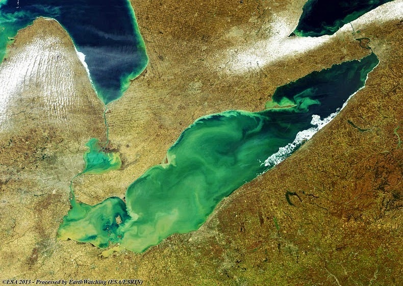
Toxic Algae Bloom on Lake Erie


Lake Erie is the fourth largest of the five Great Lakes in North America, and the 11th largest lake in the world, in terms of surface area. Lake Erie, aside from providing drinking water to the neighboring population, is a source for many waterborne commerce, navigation, and manufacturing. Outflow from Lake Erie spins the immense turbines at Niagara Falls providing hydroelectric power to Canada and the U.S. The intensive industrial development along the shores of the lake has been devastating the lake’s environment for decades with lot of issues like; overfishing, pollution and more recently fast algae blooms.
During the summer months, Lake Erie along with the rest of the five Great Lakes smothers under massive swaths of green algae, often spread over thousands of square kilometers in size. The algae flourish by feeding on excess nutrients in the form of phosphorous in the water. The phosphorus comes from sewage treatment plants and fertilizer used in farms that runoff along with rain water and enters into streams and rivers ultimately winding up in Lake Erie. Blue-green algae also prosper on light. Lake Erie, being the shallowest of the Great Lakes, particularly at its west end, is further susceptible to algae than its deeper cousins, which do not have the same penetration of sunlight. The algae float on the surface and proliferate rapidly, and when they die, they sink to the bottom of the lake, where they falloff and absorb the oxygen in the water creating dead zones where most aquatic animals cannot live. Hundreds of thousands of dead fish washed up on Erie’s shores during 2011 when the lake saw the biggest algae bloom in recorded history. The blue-green algae occupied Lake Erie covering as much as one/sixth of the surface, ranging from Toledo, Ohio to beyond Cleveland and along the Ontario shore. It stretched over 20 KM from the shores, and in the central basin it was observed at a depth of at least 60 feet.
Not all types of algae are destructive, but the bloom is primarily microcytic aeruginosa, algae that is toxic to mammals. Microcystis aeruginosa produces a liver toxin, microcystin, that commonly kills dogs swimming in infected water and causes skin irritation, respiratory difficulty and gastrointestinal distress in humans. However; algae blooms were common in the lake’s shallow western basin in the 1950’s and 60’s. Phosphorus from farms, sewage, and industry fertilized the waters so that massive algae blooms developed year after year. The blooms subsided a bit starting in the 1970,s when regulations and developments in agriculture and sewage treatment restricted the amount of phosphorus that reached the lake. But the problem has resurfaced in the recent years.Source: Amusing Planet