Thursday 26 May 2016

The White Water Terraces of Baishuitai


Baishuitai is a village (also known as White Water Terraces), between Lijiang and Shangri-La County in northwestern Yunnan province, China. It is famous for its natural minerals terraces and located foothills of north of Haba near the upper Yangtze River valley and southeast of the Shangri-la county. Baishuitai is 140 meters from its base to top and 160 meters in width. It is snugly carved into a mountain slope more than 2380 meters above sea level, making Baishuitai the biggest limestone terrace in China. The beautiful terraces, just like waving clouds and white snow, the silver terraces stretch for miles, as clear as crystal, the spring’s meander, which seem to be frozen on the terraces? The Baishuitai Terrace is a symbol for a growing flower, and the white color represents auspiciousness and sanctity. 

It is recognized as one of the most eye-catching destinations in mysterious Shangri-La and is an ancient Chinese landform with a history of 200,000 to 300,000 years. The spring water from the higher reaches of Haba Snow Mountain reaches down into the uppermost terraced basin then spills over to the basin below, which it fills up before spilling over to the next basin, and so on and so forth, until the water spills over the outer rim of the last of this set of terraced basins. Therefore, it is composed by the sediments of high calcium carbonate in the spring waters normally flow downwards from the mountain to every semicircular-shaped limestone steps. From the many centuries it has resulted into make natural terraces look as the white marbles. Moreover, the basins themselves have been hollowed out over time by the erosive action of the acidic water, which in earlier times, drew out certain minerals from the limestone, creating weak carbonic acid.

Furthermore, The Baishuitai is also the birthplace of Dongba culture & values of the Naxi Minority Group. The one of their saint of the Dongba Religion was attracted by the captivating scenery of this place on his way back from Tibet. He decided to stop there and in full swing spreading his beliefs. So fallacies prevail among peoples and they consider Baishui Water Terraces as a shrine. Since then every year, on the eighth day of the second lunar month (8th February), the Naxi people will gather here to rejoice their traditional festival by dancing and singing all day and night. The people slaughter chickens to make the festival ends with smearing chicken blood on the branches around Baishuitai Water Terraces to show their affection & love. 

A difficult mountain road leads to the Baishuitai, almost three hour drive from Shangri-la. In-fact Baishuitai is a stunning, scenic, peaceful and worthwhile place. This is perfect place for photography, so all photographers can take some majestic clicks here. 

The Lake Natron Tanzania

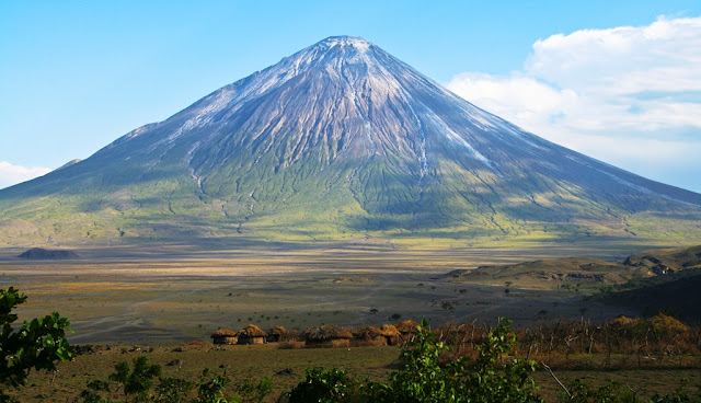
The Lake Natron is a salt and soda lake in the Arusha Region of Northern Tanzania, close to Kenyan Border in Gregory Rift. The Lake is mainly fed by Ewaso Ng’iro River, rises in central Kenya and by mineral-rich hot springs. The water level varies depend on its water. The Lake Natron is quite shallow just 9.8 feet deep, 57 KM long and 22 KM wide. The Lake temperature is falling above 40 °C (104 °F). Due to its exclusive biodiversity Tanzania has named The Lake Natron Basin to the Ramsar list of Wetlands of International significance. The Lake Natron is also the World Wildlife Fund East African halophytics ecoregion. The Lake has high levels of evaporation left behind natron, and trona (sodium, carbonate, decahydrate, sesquicarbonate dehydrate).

The Lake alkalinity reach a pH of more than 12, make surrounding bedrock is composed of alkaline, sodium-dominated trachyte lavas that were laid down during the Pleistocene period. Due to high evaporation rates, the color of lake is characteristic during the dry season, salinity levels rises at a certain point where the salt loving microorganisms starts to flourish. Therefore, halophile organisms include few cyanobacteria that make their own food with photosynthesis as plants do. Moreover,, the red accessory photosynthesizing pigment in the cyanobacteria yields the deep reds of the open water of the lake and the orange colors of the shallow parts of the lake. The alkali salt crust on the surface of the lake is also every so often colored red or pink by the salt-loving microorganisms that live there. There’re variety of plants surroundings the lake gets benefits of salt marshes and freshwater wetlands. The Lake Natron is home to some endemic algae, invertebrates, birds and fish.

Sometimes, Lake Natron temperature crosses 60 °C make the life difficult for animals and birds. The birds take advantage of the lake’s extreme conditions, which keep their predators at bay, and more than 2.5 million lesser flamingos flock there during breeding season. Three-quarters of the world population of lesser flamingos (Hoenicopterus minor) live in East Africa and use Lake Natron as their nesting site. Every year countless lesser flamingos have flocked to Tanzania's Lake Natron to start nesting, but mainly depend on the combination of environmental factors. The gathering is one of nature’s fantastic spectacles. It’s a regular breeding area of 2.5 million flamingoes, whose status is close to “near-threatened” on the ICUN Red List. These flamingoes, gather along nearby saline lakes to feed on a blue green algae with red pigments, called “spirulina”.

The high salinity & cyanobacteria support more nests; as greater flamingoes breed on mud flats, also it is a safe breeding place due to its caustic environment is a barrier against predators trying to reach their nests on seasonally forming evaporates islands. When the water level is just right, salt islands are exposed in the center of the lake, given that the impeccable nesting site. However, if the Lake is too dry, predators are able to reach the young birds and eaten them, and if there is too much rain, the nests can be flooded, so the conditions must be perfect for a successful breeding season. Moreover, there are two endemic fish species; the alkaline tilapias Alcolapia latilabris and A. ndalalani flourish in lake water at the edges of hot spring inlets. The surrounding area is not inhabited but some herding and seasonal cultivation take place. Further, there are a number of campgrounds near the lake, which is also the base for climbing Ol Doinyo Lengai. The Lake Natron also provides support for 100,000 other water birds, many of which are Palearctic migrants.

Moreover, The most interesting, strange thing about this lake are the solitary, mummified birds which can be sporadically found along its shoreline, calcified over a long period of time and turned into fossils. The surrounding area of Lake Natron contain some of the most astonishing scenery in Africa also a home to some wildlife, the occasional giraffe or zebra warthogs and many more. The other attraction in the area are: the Mountain “Ol Doinyo Lengai”, the combination of broad open plains, sheer rift escarpments, enormous freestanding volcanoes and the vast multi-coloured soda lake itself is a home to a fascinating eco-system which thrives in this severe environment is absolutely magnificent.

The construction of dike at north end of lake and planned hydroelectric power plant on the Ewaso Ng’iro in Kenya increases the threats of dilution to this breading area may still be serious. Hence, there is no formal protection. Another big threat is a proposed plan of soda ash plant on its shores to pump the lake water to extract the sodium carbonate to convert to washing powder, along with more than 100 workers housing, and coal fired power station to provide energy for plant complex. In addition, there is a possibility the developers may introduce a hybrid brine shrimp to increase the efficiency of extraction. Due to these threats, the lesser flamingoes continuing to breed in the face of such mayhem is next to zero, and will leave lesser flamingoes in extinction.

Wednesday 25 May 2016

Fairy Circles: A Lingering Mystery


The strange and mysterious patches in the grasslands of Namib Desert is called “Fairy Circles” in Southern African have challenged explanation with hypotheses ranging from ants to termites to grass-killing gas that seeps out of the soil. Thus, the bird-eye shows, the Namibian desert looks like it has a bad case of chicken pox, well spread across 1,100 miles of a narrow strip sit a smattering of barren polka dots. However, from several decades, a number of theories, from alien invasion to poisonous gasses have been put forth to explain the phenomenon. In fact “Fairy circles” have been a long mystery to scientists and it is discovered that small fairy circles last for an average of 24 years, whereas larger circles can stick around for up to 75 years. It is not sure, why the circles form in the first place, or why they disappear. The mysterious fairy rings have many theories for what lies behind the patches of bare earth. One of them is dragon’s breath, burn marks and dragons living beneath the ground, UFOs, radioactive soil, termites and competition between the plants for scarce resources of nutrients and water. The Fairy Circles transform the landscape into something more like the surface of moon. 

The Fairy Circles can be 6 to 40 feet in diameter can found in the region’s arid grassland on sandy soils. There is ring vegetation around the edge of the ring is taller than the surrounding grassland. They are one of nature's greatest mysteries, prompting local legends they are created by Gods and making wild theories about visits by UFOs. The vast areas are well covered by the mysterious fairy circles that pock the gray desert of Namibia captivated the imaginations of visitors in this region. But now scientists are getting on a series of projects intended at lastly unravelling what causes these strange circles of bare earth to form in their millions.

AS the scientists had done several theories for the explanation of Fairy Circles, but not conclude on definite reasons yet. Perhaps Termites seems to be the most popular authentic theory. The sand termite species “Psammotermes allocerus” was the most likely suspect for creating the fairy circles. The insect was the only species constantly present across the 1,200 miles of desert which included the circles. The local peoples are also having different thoughts of fungi, spirits and even dragon theories. However, it is difficult to form an opinion about something which is still a mystery, and investigated for years. Another activity of termites building nests beneath the ground causes the release of poisonous gas that causes the plants above to die. The pathogenic fungi may be responsible of patches where highly toxic euphorbia bushes grew. 

Moreover, a latest theory suggested the circles follow patterns of rainfall and may be caused by competition between plants themselves, with circles of stronger more vibrant grasses sucking nutrients and moisture from the deprived soil in the center and rainfall is an imperative predictor of fairy circles. However, there are many competing theories which have generated fervent factions within the scientific community. The fairy circles appear in a surprisingly regular hexagonal pattern, almost like a honeycomb. This seems to disregard the idea that belches of poisonous gas from below ground are killing the plants and the role of social insects. Only self-organization is recognized to cause patterns like this at such a large scale.

The vegetation gap expands as the competition ensues, and the grass-free zone becomes a reservoir for nutrients and water. With the additional resources, larger grass species are then able to take root at the periphery of the gap, and a stable fairy circle develops. Scientists have also previously proposed that fairy circles are an example of a "self-organizing vegetation pattern," which arises from plant interactions. In 2008, researchers developed a mathematical model showing the vegetation patterning of fairy circles could depend on water availability. Mr Dressler, 58, from Marbella, Spain, visits three times to this area between 2010 and 2014. He said: I came across this marvel by chance during one of my very first visits. Indeed it was very exciting to fly over the area for the first time. Source: Charismatic Planet

The Great Blue Hole, Belize

In Belize, a small country has a natural wonder of giant sinkhole named “The Great Blue”. Off the coast of Belize, it lies close to center of lighthouse Reef, 70 KM from the Belize City. The Great Blue Hole is in circular shape, 300 meter across and 124 meter deep which is the most often cited depth up to this day. The name “The Great Blue Hole” was devised by British diver and author Ned Middleton in the book “Ten Years Underwater”. So, this name is so popular nowadays. In 2012 Discovery Channel ranked the “Great Blue Hole” as number one on its list of "The 10 Most Amazing Places on Earth". Many different fossils have been discovered that indicate the type of life forms that existed in Great Blue Holes. Other life forms such as marine life and marine fossils have also been noticed Crocodile and tortoise fossils have been found in blue holes.

The Great Blue Hole formation took place more than 150,000 years ago, when it was formed during several episodes of quaternary glaciation when sea levels were much lower. However, with the passage of time, the sea level began to rise, the cave was flooded. The Great Blue Hole is considering one of TOP 10 scuba diving place in the world. Moreover, The Great Blue Hole is a part of the larger Belize Barrier Reef Reserve System, a World Heritage Site of the United Nations Educational, Scientific and Cultural Organization (UNESCO). Normally a day trip to the Great Blue Hole is full-day trips from the coastal tourist communities in Belize. Stalactites were retrieved from submerged caves, off-vertical by 5˚ in a consistent orientation, signifying that there had also been some past geological shift and tilting of the underlying plateau.

This is one of favorite site among the recreational scuba divers. They’re enticing by the great opportunity to dive in crystal clear water. This is a popular spot among recreational scuba divers who are lured by the opportunity to dive in sometimes crystal-clear water and meet several species of fish, including Midnight Parrotfish, Caribbean reef shark, and other juvenile fish species. There’re many types of sharks species reported here, like bull shark, hammerheads shark are among popular here, though not regularly sighted. Moreover, on-shore caves of related formation, as large collapsed sinkholes, are well recognized in Belize and in the Yucatán Peninsula, where they are identified as cenotes. Contrasting the mainland cenotes which frequently link to underwater cave systems, there is little evidence of horizontal development in the Blue Hole. The Great Blue Hole is not for all divers, you must be very perfect of having all types of diving skills, enables you to witness a dark cave with impressive stalactites.  Source: Charismatic Planet

Monday 23 May 2016

The Jaisalmer Fort of Rajasthan


The Jaisalmer Fort is built in 1156AD by the Ruler Rawal Jaisal. The fort name is derives from Rajpur ruler, is one of largest fortifications in the world. Jaisalmer Fort is situated in the city of Jaisalmer, in the Indian state of Rajasthan. Jaisalmer’s is an exclusive fort is a living urban center, with more than four thousand people residing within its walls. It’s honeycombed with narrow, winding lanes, lined with houses and temples along with a large number of handicraft shops, guesthouses and restaurants. The Jaisalmer Fort is 1500 feet long, 750 feet wide actually built on a hill that raises above a height of 250 feet. The basement of the fort has 15 feet tall wall forming a double line of defense has four entrances to the town side, one of which used to be guarded by cannon.

The Fort is one of Rajasthan's most popular tourist attractions with as many as 500,000 to 600,000 tourists visiting it annually abuzz with commercial activities and has seen a phenomenal growth in both human and vehicular traffic. In fact, this is oldest and massive fort of remote Thar Desert of Rajasthan. In the medieval times, the ancient Jaisalmer fort came to be celebrated for the chivalry and bravery of its rulers and also for the aesthetic sense represented by its palaces and Havelis. There are five palaces inside the Jaisalmer fort and are known as Sarvottam Vilas, Akhai Vilas, Gaj Mahal, Rang Mahal and Moti Mahal. Therefore the most famous of all the palaces, the Rang Mahal also has mural paintings to attract the tourists. So, it is thought, the winter months between October and February are most definitely the best time to visit Jaisalmer Fort. 

In 2013 the massive fort is declared UNESCO World Heritage Site stands amidst the sandy expanse of the great Thar Desert, on Trikuta Hill, and has been the scene of various battles. The Fort walls changes the color by yellow sandstone are tawny lion color in the middle of day, however fading to honey gold close to the sun sets thereby camouflaging in the yellow desert. Therefore, for this particular reason, the fort is also famous as the “Sonar Quila” or “Golden Fort”.  The fort is known a formidable monument in this region as it is located in the middle of the city. The Fort contains three layers of wall, made out of solid stone blocks and strengthens with loose rubble of Trikuta hill. 

The Jaisalmer Fort has an ingenious drainage system called the “ghut nali” lets the easy drainage of rainwater away from the fort in all four directions of the fort. But in last fifty years or so, haphazard construction activities and building of new roads has greatly reduced its effectiveness. Moroever, 6 forts of Rajasthan, namely, Jaisalmer Fort, Gagron Fort, Amber Fort, Chittorgarh Fort, Kumbhalgarh and Ranthambore Fort were included in the UNESCO World Heritage Site list in June 2013. They were recognized as a serial cultural property and Rajput military hill architecture. The colorful art forms and royal heritage made it appear paler in comparison. Though, the craftsmen were generally Muslims who were induced on their journey to exhibit their skills. The results were architectural purity that cannot be seen elsewhere.

The Jaisalmer Fort began in 1196 and it took 7 years to complete, and subsequent rulers kept making additions and alterations to it. The Jaisalmer Fort was once home to the Rajputs a warriors and trader tribe for many centuries, prospered by levying taxes on the merchants who wound between Egypt, Persia and India built a network of intricate fortresses to defend themselves and their accumulated wealth. In 1276, the King Jetsi strengthened the fort against Sultan of Dehli, who was incessantly invading with his trained soldiers and destroyed the castle. 

However, in 1306 the brave Dodoo was taken control of Fort, and subsequently started building the fort. Moreover Muslim king Ala-ud-din Khilji attacked and captured the fort in the 13th century and managed to hold it for nine years.  In 1541, another Muslim Mughal Emperor Humayun attached the fort city and captured the fort. After that Muslim Mughal Emperor Babur and subsequently seeded Akbar in 1570 take the control of fort. So, Fort was under control of Muslims Mughals until 1762, when Maharawal Mulraj took control of the fort. After the death of Mulraj in 1820, his grandson Gaj Singh took reigns of the fort. 

The famed fort has withstood earthquakes and sandstorms for a millenia, but now shifts and crumbles. The ever increasing population is a major threat and putting pressure on fort existence. The water seepage, inadequate civic amenities, derelict houses, seismic activity around the Trikuta Hill is mainly impacting on fort. Jaisalmer Fort has been built with a weak sedimentary rock foothill, which makes its foundation particularly vulnerable to seepage. Due to seepage, the substantial proportion of the Fort like, Queen’s Palace or Rani Ka Mahal and others outer boundary wall and lower pitching walls has collapsed. 

The fort is deteriorating, and dire need of extensive water-management infrastructure could not have been foreseen by the builders of this desert city, and changing weather patterns increasingly frequent and severe monsoons are jeopardizing the fort. In 1996, the World Monuments Fund included the Fort in his report due to the threats posed to by ever increasing population and up surging number of tourists who visit every year.  Nowadays, the Rajasthan Urban Infrastructure Project, a joint government of Rajasthan and Asia Development Bank project, is now in the process of providing the needed upgrades to the fort’s drainage systems. And in 2010, WMF provided support for the emergency stabilization of the structure. So, it is a must-visit for history buffs and those keen on learning about the heritage of Rajasthan. Source: Charismatic Planet