Showing posts with label Russia. Show all posts

Thursday 3 September 2015

Mud Volcano that has Supernatural Resemblance to a Massive Human Eye


These unbelievable photographs show a spectacular mud volcano which looks like a huge human eye when captured from the sky. The erratic phenomenon was caught on camera on the Sakhalin Island, East Russia, at the Pugachevskiy mud volcano. From high above, the center of the volcano looks like the pupil, surrounded by a muddy brown iris. The 40 years Old Russian photographer Mikhail Mikhailov said, I didn't ever see anything like this before.

Although, there’re a lot number of mud volcanoes in the world, but this one is really special because it is resembles with the human eye. I haven't ever seen it looking like an eye! It is strongly believed, that it was a formed with a very strong eruption, the mud was getting out from one point and got spread around evenly. Therefore, the consequences created a very stunning view, looking exactly like an earth eye especially from a helicopter. It is for sure a rare and exclusive phenomenon. Generally mud volcanoes are formations created by geo-excreted gases and liquids, though the process can vary somewhat. As de-compaction occurs, gases are produced at a high rate, causing mud to become tough. As the pressure builds up, the mud is released out of the volcano through fractures in the structure. Well, the largest concentration of mud volcanoes can be found in Azerbaijan, which boasts around 400 in total, some of which have created perpetual and temporary islands. 

Wednesday 2 September 2015

Valley of Geysers, A Natural Wonder in Kamchatka Russia

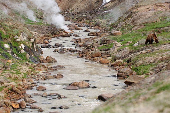
The Valley of Geysers is a geyser field on Kamchatka Peninsula, Russia, and has the second largest concentration of geysers in the world. This six kilometers  long basin with around 90 geysers and various hot springs is located on the Kamchatka Peninsula in the Russian Far East, mainly on the left bank of the ever-deepening “Geysernaya River”, into which geothermal waters flow from a fairly young stratovolcano, Kikhpinych. It is part of the “Kronotsky Nature 
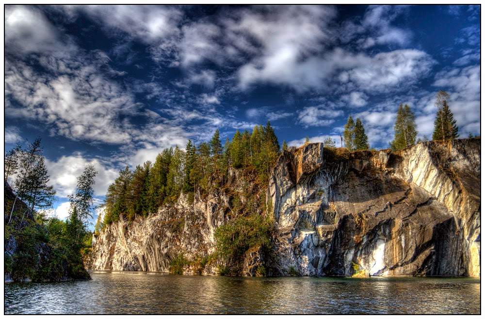
Reserve”, which, in turn, is included into the World Heritage Site "Volcanoes of Kamchatka" and temperatures have been found to be 250 °C, 500 m below the caldera ground. The valley is one of the rare places in the world where geysers occur naturally, along with Yellowstone National Park in the United States and sites in Iceland, Chile, and New Zealand. The access to valley is extremely difficult; you can reach with helicopters available the only feasible means of transport.

In 1942 a local scientist “Tatyan Ustinova” has discovered the "pulsating" geysers of Kamchatka. Therefore, she revealed her findings after 14 years later and little exploration of the area until 1972. As the time goes, an idea was introduced to get systematic survey to be done in mid-1970 and later on, an automatic monitoring system was introduced in 1990. Out of hundreds geysers, only 30 geysers were given names. Hence one of massive geyser “Velikan” is capable of generating a jet of water reaching up to 130 feet. So, in the early 1980’s the area was promoted across the USSR, and popularity increase in the tourist magnets of Kamchatka and Russian Far East. However, foreigner visitors were permitted into valley in 1990. Almost more than 3000 tourists visited valley of Geysers annually.  The valley is an extremely paradise, steaming waterfalls cascade down the valley walls; grassy banks breathe with life; geysers erupts jets of boiling water; and bubbling mud pots gurgle and pop. Beautiful multicolored clays and algae- matted waterslides mark the landscape, and wafting aromas bear witness to sulfur-belching springs.

The Valley of Geysers has seriously suffered from the landslide on June 3, 2007, a gigantic mudflow inundated two thirds of the valley witnessed an exclusive natural event, but the consequences of such a natural catastrophe are irreversible. Therefore, the World Heritage Site has also expressed its deep concern over the issue. In fact this was a tragic event for humankind, in that we have lost one of the best rare natural wonders of the world. On June 5 2007, it was reported that a thermal lake is forming above the valley due to the landslide occurred while the documentary Wild Russia was filmed; it features footage of before and after the disaster. The extent of long-lasting change is not yet clear, but may be less than was originally thought. As of June 9, 2007, waters have receded to some extent, revealing some of the inundated features. Velikan (Giant) Geyser, one of the field's largest, was not buried in the slide and has in recent times been observed to be active. In 2008 the Valley of Geysers was elected as one of seven Wonders of Russia, because of several thousand people visit the Valley every year because of its remote location and reserve status. Nonetheless, the Valley is still very alive and attracts a lot of interest from scientists and tourists.

Monday 22 June 2015

Moscow 2014 Timelapse/Hyperlapse

From Kirill Neiezhmakov says at winter cloudy day city reminds old movie, but at nightfall Moscow transformed! This night TimeLapse in Motion filmed at winter in Moscow (Russia) during 5 nights.
Wow, This is really well done! and thought the editing and pacing of this piece was spot on. The amount of time that had to go into those hyper-lapses shows in their quality. Great job and showed quite a bit of passion here!

Shooting, post-processing and editing by Kirill Neiezhmakov
e-mail: nk87@mail.ru
vk.com/nk_design
music: Glitch Mob - Warrior Concerto
YouTube 1080p: youtu.be/leqyze7Py0o
Behind the Scenes are here youtu.be/wIZEqyPpqIE
Footage (this and many other) available for licensing in 4K
Equipment:
Canon 60d
Sigma 10-20 mm 4.0-5.6
Samyang 8 mm 3.5
Zenitar-M 50 mm 1.7
Canon 70-200 4L
Vanguard Alta Pro tripod


Moscow 2014 Timelapse/Hyperlapse from Kirill Neiezhmakov on Vimeo.

Wednesday 3 June 2015

Udachnaya Pipe, The World Third Deepest Open-Pit Diamond Mine in Russia


The Udachnaya pipe is also called lucky pipe actually a diamond deposit in the Daldyn-Alakit kimberlite field in Sakha Republic, Russia. The Udachnaya is one of main diamond suppliers in Russia and about 80% and almost half of the world’s proved diamond resources are located on the territory of the Republic of Sakha Yakutia. This is an open-pit mine is located just outside the Arctic circle at 66°26′N 112°19′E. 

In June 15, 1955 The Udachnaya pipe was discovered right after two days after the discovery of another diamond pipe Mir by Soviet geologist Vladimir Shchukin and his team. The open-pit mine is over 1,970 feet deep, making it the third deepest open-pit mine in the world after Bingham Canyon Mine and Chuquicamata. Moreover, the nearby settlement of Udachny is named for the deposit. Currently Udachnaya pipe is well controlled by Russian diamond company Alrosa, which planned to halt open-pit mining in favor of underground mining in 2010. 

The Udachnaya pipe mine has estimated more than reserves of 225.8 million carats of diamonds and an annual production capacity of 10.4 million carats. The development of the rough diamond geological exploration will focus on localizing, exploration, evaluation and prospecting of potential diamond-bearing areas in the Yakutsk diamondiferous province. At present, the localizing commercial diamond deposits are connected with the Sredne-Markhinsky and Muno-Tungsky diamond-bearing areas, where the new kimberlite bodies rich in diamonds and can be discovered, as well as buried high-quality diamond placer deposits. Moreover, it is also planned to enhance the diamond exploration works by 3.5 per cent per year of the value of the diamonds mined in the Republic in order to replenish the utilized reserves and discover new promising kimberlite and alluvial deposits. Source: Charismatic Planet


Sunday 8 February 2015

Marble Lake in Ruskeala, Russia

This is marble quarry in Ruskeala, Karelia, which has been now lake with marble lakesides. It’s all depending from the light's direction the water could be almost black, with a good contrast to white marble rocks, or clear with an interesting greenish hue. Moreover through the water you can see some marble stones; in fact they are located on the deepness of several meters. The most attractive Ruskeala marble quarries, filled with vibrant emerald green subterranean waters, are a distinctive natural monument and an object of mining culture.

An international tourist route; Blue Highway (Norway/Sweden/Finland/Russia) goes through Ruskeala. The quarry site has been designed to become Ruskeala Park, a regional park. A series of small cascade waterfalls on the Tokhmayoki River is another popular tourist attraction located near the settlement. The history tells, that in 1766 a marble deposit was revealed near the Village of Ruskeala. In the subsequent years à marble quarry was opened, which could deal four brands of marble, ash-grey, grey-green, and white with grey streaks and white-grey- blue.

The marble was used for buildings in St. Petersburg in the second half of 17th the middle of the 20-th centuries and in Sortavala and Valamo in the late 19th-early 20th centuries. There has also been à lime production based on the marble in Ruskeala. The marble was quarried in open cuts and in adits. By now three cuts have been opened along the left bank of the river Tohmajoki. The cuts are somewhat flooded and the water is encircled by sheer marble rocks. The cuts are linked with each other by adits. Some other objects of interest have been preserved, for example an old administration building made of the Ruskeala marble in the Classic style.

Saturday 13 December 2014

The Rock Piller of Krasnoyarsk Stolby Nature Reserve


Krasnoyarsk Stolby Nature Reserve is situated on the southern bank of the Yenisei River, bordering the city of Krasnoyarsk, in Russia. The foremost attraction of the park is its towering stone pillars that have peculiar curved forms and reach up to 100 meters in height. These rocks are mostly of sedimentary and volcanic origin, aged from the Cambrian period, almost over 600 million years ago, to the Carbon period. They were shaped when molten magma penetrated the surface from a depth of 500 to 1500 meters into a layer of peneplain where it formed a system of cracks that spread naturally across the whole layer. Selective weathering along those cracks led to the formation of mattress-like prismatic detachments, which caused unique shapes on the rock outcrops. The place was discovered in 1624 by Russian kozaks - the explorers of Siberia, who built a small fortress at the influx of the Kacha River into the Yenisei. They wondered at the enormous intricately shaped stony blocks rising amid a thick forest and gave them the biblical name "Stolpy", abridged later to the widespread "Stolby", plural for “stolb” which means “pillar” in Russian. Since then the name came into use for these and any similar rocky features in Siberia and the Russian Far East and was accepted as a geological term. Stolby is also a major rock climbing site. A lot of local climbers deliberately do not use any belaying equipment, an ability the Krasnoyarsk rock climbers have mastered over the years. They call their exciting sport stolbism, famous elsewhere as solo climbing.

Kungur Ice Cave Russia


Kungur Ice Cave is a lovely karst cave situated in the Urals, near the town Kungur in Perm Krai, Russia, on the banks of the Sylva River. This remarkable cave has a length of explored passages over 5 kilometers. Though this is one of Russia’s biggest karst caves and the only one in the country equipped for visits by travelers. Over thousands of years rainwater dissolved the soft rocks and formed a system of capacious underground halls, filled with rocks of unusual shapes. Therefore; snow-melt dripping through the porous rocks had frozen in the cold interior of the cave to turn into ice stalactites that hang from the ceiling in entirely impulsive forms and extraordinary sizes. Amazingly some of the hanging icicles have reached the floor and formed spectacular ice columns shaped like giant hourglasses .One of the most beautiful places in the cave is right near the entrance “The Diamond Grotto”. Layers of ancient ice in these chambers overflow under spotlights, bringing to mind a frozen waterfall, while vaults cover large crystals. Diamond grotto adjoins Polar grotto where it is possible to observe ice stalactites and stalagmites.

 In the grotto of Pompeii Ruins visitors can see rocks of strange shape some of them resembling silhouettes of animal and fantastic characters, thanks to the special system of illumination. Well overall, Kungur Cave encompasses 48 grottoes, but each having their own story and exclusive name. i.e. there’re  the Coral and Sea Bottom chambers, which’re beautifully ornamented with stone lace that water wore away for 12,000 years. In the Meteorite chamber, a spectator has the illusion that massive celestial bodies are lying under the earth. The history tells us, that the first plan of the ice cave was made in 1703 when Peter the Great issued the decree sending the famous geographer Simeon Remezov. When they’ve used the materials of Remezov drawings, Stralenberge made one of the first schemes of the cave which we can see now. 

The first regular excursions of the ice cave were made by Alexey Timofeevich Hlebnikov, the grandnephew of the Russian America researcher K.T.Hlebnikov. Hence in 1914 Hlebnikov, having rented the cave from a local community of peasants, started to arrange paid excursions for inhabitants of Kungur and visitors of the city. Owing to Alexey Hlebnikov's diligence, the news about Kungur’s outstanding ice cave speedily scattered to diverse corners of the country. Nowadays the cave is a popular destination and every year thousands of visitors pay the visit to this cave. Source: Charismatic Planet