Showing posts with label Canada. Show all posts

Wednesday 15 October 2014

Mount Babel Alberta, Canada


Mount Babel is a 10,173 feet (3,101m) mountain peak in the Ten Peaks in Alberta, Canada. As per Peakery data, it ranks as the 140th highest mountain in Alberta and the 258th highest mountain in Canada. The adjacent peaks are Mount Fay, Mount Little, Mount Bowlen, Tower of Babel, Quadra Mountain, and Bident Mountain. Mt. Babel is one of the most popular mountains in the Valley of Ten Peaks that beautifully surrounds Moraine Lake in Banff National Park. The smaller and less known Consolation Lakes lie just behind Mt Babel. 

The stunning lakes can only be reached by climbing across the rockslides that have tumbled down from towering Mt Babel. These images shows the gorgeous beauty of autumn colors of the golden yellow larches on the rocky slopes of Mt Babel and some of them are very big rocks that lie just at the edge of the first Consolation Lake. The dramatic Mount Babel rises vertically some 1000 metres above the Consolation Valley, and the mountain was the scene of one of the most dramatic rescues in the history of the National Park Warden Service. The rout to Mount Babel is really an impressive rock route, because it cannot be called a classic (having only been climbed twice) but it definitely offers a thrilling day's climbing. It could be an astonishing effort for the time when it was first climbed. The majority of the route is now free, with a limited points of aid that keep the grade reasonably sensible. 

Therefore the approach trail (Consolation Lake Trail) to the Tower of Babel is a commonly used trail among the tourists who are delivered in mass by bus to the Lake Moraine Lodge. The one of pictures shown below is actually stitched together from 15 separate images as it is not possible to get this enormous mountain at such close range into a single shot even with a very wide angle lens. The image is taken by standing on a small island in the wide outlet channel from the lake. The gorgeous Mt. Babel can be reached depends upon your fitness level, as you’ve to walked from one rock to another to cross to the island. For the time being, if you look closely you may see tiny companion sniffy stuck on top of a sharp and steep sided boulder middle foreground just at the water's edge. Mount Babel was first climbed by A Hart, Edward Oliver Wheeler, L. Wilson and H. Worsfold in 1910. 

Ten other mountain peaks nearby to Mount Babel 

1.            Mount Fay (3234 m)                         1.1 km
2.            Mount Little (3134 m)                        1.8 km
3.            Mount Bowlen (3206 m)                   1.8 km
4.            Tower of Babel (2221 m)                   2.1 km
5.            Quadra Mountain (3174 m)             2.2 km
6.            Mount Perren (3051 m)                     3.2 km
7.            Mount Allen (Canada) (3310 m)     4.3 km
8.            Mount Tuzo (3248 m)                         4.5 km
9.            Chimney Peak (3002 m)                    4.8 km
10.         Mt Deltaform (3424 m)                       5.4 km

Friday 10 October 2014

Mount John Laurie Canada


Mount John Laurie is a mountain in the Canadian Rockies, officially named in 1961 and famous as Mount Laurie, or by the Nakoda name name Yamnuska (unofficial name), or simply Yamnuska which means (wall of stone), and it is located in the province of Alberta, Canada. The word Yamnuska" is perceived from the Stoney Nakoda word "Iyamnathka" that describes steep cliffs or "the flat faced mountain." Actually John John Lee Laurie, (1899-1959), was an educator and political activist and a founder of the Indian Association of Alberta.

The Mount Laurie is the most easterly mountain in the valley and features very steep, often vertical and overhanging south cliff 360 metres in height and almost two KM in width. The mountain's 1961 renaming came at the request of the Stoney Nakoda First Nation. Laurie, an educator and political activist, served as secretary of the Indian Association of Alberta from (1944-1956), encouraging the causes of Alberta native peoples. Mount Laurie is standing at about 2,240 meters above sea level, and is the first mountain on the north side of the Bow River valley (Bow Valley) as it exits the mountains for the foothills and prairie of Alberta. It is well situated close to Calgary; and it is a widespread "Great Scramble". It is also very famous for rock climbing destination, with more than hundreds routes of all difficulty levels spread out across its face.

Mount John Laurie is the result of the McConnell Thrust Mistake, which put the resistive, cliff forming Cambrian carbonate rock of the Eldon Formation on top of the much younger and weaker Cretaceous aged, clastic Belly River Formation. The error, which sits at the base of the cliff face, represents an age variance of around 450 million years. The access is to mount Laurie is at the Highway 1X and Highway 1A (Bow Valley Trail) intersection, travel east for two kilometers. Turn into the signed parking lot that says "Yamnuska”.


10 other mountain peaks closest to Mount John Laurie:

1.                Mount Yamnuska (2240 meters)                                    0.0 km
2.                Mount Fable (2702 meters)                                             7.6 km
3.                Heart Mountain (2135 meters)                                       9.2 km
4.                Grotto Mountain (2706 meters)                                     11.4 km
5.                Mount Sparrowhawk (3121 meters)                              11.5 km
6.                Mount Lady MacDonald (2605 meters)                       14.0 km
7.                Mount Baldy (2192 meters)                                             15.0 km
8.                Squaw's Tit (2514 meters)                                                15.4 km
9.                Mount Charles Stewart (2809 meters)                           15.5 km
10.              Middle Sister (2769 meters)                                             17.2 km


Friday 11 April 2014

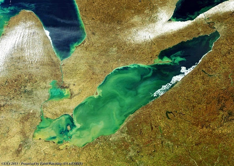
Toxic Algae Bloom on Lake Erie


Lake Erie is the fourth largest of the five Great Lakes in North America, and the 11th largest lake in the world, in terms of surface area. Lake Erie, aside from providing drinking water to the neighboring population, is a source for many waterborne commerce, navigation, and manufacturing. Outflow from Lake Erie spins the immense turbines at Niagara Falls providing hydroelectric power to Canada and the U.S. The intensive industrial development along the shores of the lake has been devastating the lake’s environment for decades with lot of issues like; overfishing, pollution and more recently fast algae blooms.
During the summer months, Lake Erie along with the rest of the five Great Lakes smothers under massive swaths of green algae, often spread over thousands of square kilometers in size. The algae flourish by feeding on excess nutrients in the form of phosphorous in the water. The phosphorus comes from sewage treatment plants and fertilizer used in farms that runoff along with rain water and enters into streams and rivers ultimately winding up in Lake Erie. Blue-green algae also prosper on light. Lake Erie, being the shallowest of the Great Lakes, particularly at its west end, is further susceptible to algae than its deeper cousins, which do not have the same penetration of sunlight. The algae float on the surface and proliferate rapidly, and when they die, they sink to the bottom of the lake, where they falloff and absorb the oxygen in the water creating dead zones where most aquatic animals cannot live. Hundreds of thousands of dead fish washed up on Erie’s shores during 2011 when the lake saw the biggest algae bloom in recorded history. The blue-green algae occupied Lake Erie covering as much as one/sixth of the surface, ranging from Toledo, Ohio to beyond Cleveland and along the Ontario shore. It stretched over 20 KM from the shores, and in the central basin it was observed at a depth of at least 60 feet.
Not all types of algae are destructive, but the bloom is primarily microcytic aeruginosa, algae that is toxic to mammals. Microcystis aeruginosa produces a liver toxin, microcystin, that commonly kills dogs swimming in infected water and causes skin irritation, respiratory difficulty and gastrointestinal distress in humans. However; algae blooms were common in the lake’s shallow western basin in the 1950’s and 60’s. Phosphorus from farms, sewage, and industry fertilized the waters so that massive algae blooms developed year after year. The blooms subsided a bit starting in the 1970,s when regulations and developments in agriculture and sewage treatment restricted the amount of phosphorus that reached the lake. But the problem has resurfaced in the recent years.Source: Amusing Planet