Showing posts with label Namibia. Show all posts

Thursday 16 May 2019

Kalahari Desert in Africa

Kalahari Desert Location
The Kalahari Desert stretching more than 360,000 square miles across South Africa, Namibia, and Botswana. The annual rainfall is a bit high between 5 to 10 inches. The Kalahari Desert is part of Kalahari Basin, (930,000 square-kilometer), includes Okavango River Delta and other wetlands areas.

Kalahari Desert Facts

The Kalahari Desert is something very attractive name to inspire you most. Probably we don’t know why. The desert name instills a sense of dismay while at the same time. This emanates an uncanny attraction. You may have different thoughts in the strictest sense of the word. The Kalahari Desert gently undulating, sand-covered plain, and bedrock are exposed in the low kopjes (vertical-walled hills), that rarely but conspicuously rise above the general surface.

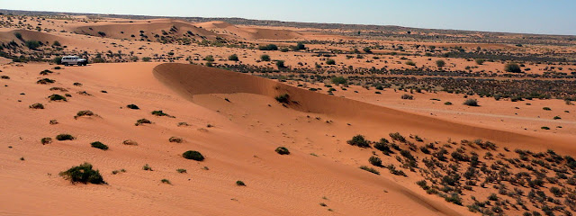
Apart from kopjes, three surfaces characterize virtually all the Kalahari: sand sheets, longitudinal dunes, and vleis. The major part of Kalahari Basin encompasses all of Botswana and more than half of Namibia. The sand dunes, stretching west to the Namib Desert, is the largest continuous expanse of sand on earth. The western side of Kalahari Desert is consisting of long chains of dunes, measure at least 1 mile in length, several hundred feet in width, and 20 to 200 feet in height. The Southern part of Kalahari Desert has water surface in small and widely scattered waterholes. Almost, entire rainwater falls disappear immediately into the deep sand.

The desert soils mainly based on reddish color sand, and are low in organic material. Soils in the Kalahari Desert are largely based on sand, are reddish in color, and are low in organic material. Chemically, they are comparatively alkaline, and dry soils tend to be highly calcareous or saline, and normally they are toxic to most vegetation. Around, 5,000 Kalahari people speak Taa Language with the most vowels and consonants. However, in Tswana language, The Kalahari means ‘large thirst’.  Ancient dry riverbeds which are called ‘omuramba’—traverse the central northern reaches of the Kalahari and offer standing pools of water during the rainy season.

The Kalahari Desert is 6th biggest desert by area in the world and second biggest in Africa after the Sahara Desert. Geologist says the Kalahari Desert was once thriving with full of life with numerous lakes exist here. But these days, large salt pans remain i.e., Makgadikgadi Pan, the remains of the once huge Lake Makgadikgadi. Another big pan is the Nxan pan. The most popular game, named “Mario Kart” features a track named Kalimari Desert.

This track was inspired by the Kalahari Desert. Because of its sparsely populated expanse, the Kalahari is served by infrequent roads and tracks. Furthermore, Kalahari Desert is home to one of the biggest diamond mines in the world. The diamonds were unearthed almost thirty years ago in the Gaghoo Mine first opened in 2014. Hence after three years of construction completed the project. This mine extracts diamond ore using a GO25 Kimberlite Pipe and has a production capacity of 720,000t a year.

People of Kalahari

The Kalahari Desert is inhabited mainly by Bantu speakers and Khoisan-speaking San, with a little number of Europeans, entered in the 19th century as travelers, missionaries, ivory hunters, and traders. It is believed that nomadic hunter (San People) lived at the Kalahari Desert for over 20,000 years. They are the oldest continuous residents of Southern Africa. 

Many San people were killed during various wars when European settlers arrived here. Their life was disturbed by large scale killing of wild animals which they earlier hunted and grazing of wild edible plants by cattle. Interestingly, more than a hundred thousand of San people still live along the fringes of the Kalahari.

Some precious diamonds, deposits of nickel, copper, and coal have been unearthed here. The major livestock grazing is thought to be the largest threat to the Kalahari ecosystem. The ongoing change to plant communities and increased erosion remains relatively limited.                                 

The weather of Kalahari Desert

The sand dunes mainly covered with an abundance of vegetation i.e. grass tussocks, shrubs, and deciduous trees infrequent precipitation and wild swings in temperature. In the summer season, it is scorching hot to touch 45 degrees Celsius, and in winter, temperature drop to -15 degrees Celsius. Also, in winters the climate is extremely dry: humidity is very low, and no rain falls for six to eight months.

Further, the moisture-bearing air is derived from the Indian Ocean, and precipitation is greatest in the northeast and declines toward the southwest. Rainfall, however, is extremely variable. Most of the rain comes as summer thunderstorms, with great variation from place to place and from year to year.

The wetter open woodlands made with acacia famous as camelthorn tree. These camelthorns are a crucial part of the desert ecosystem, manufacturing nutrients that boost other plants to grow around its base and providing shade for animals. The Kalahari Desert had an intricate climatic history more than millions of years ago, in line with major global changes. 

The last 250,000 years have been reconstructed from numerous data sources, and offer evidence of both former extensive lakes and periods drier than now. As time goes, Kalahari Desert has expanded to include parts of western Zimbabwe, Zambia, and Angola.

Flora and Fauna

Around 500 species of vegetation thrive during the rainy season. The water quality is better than a normal desert. The water helps in to flourish the plant life in many parts. The Hoodia cactus, and other edible plants - used by both humans and animals include creeping tsamma melons, gemsbok cucumbers, and wild cucumbers. 

Other trees that grow in the Kalahari Desert include shepherd's tree, blackthorn, and silver cluster-leaf. In the drier area, has vegetation and wildlife are much sparser, but Hoodia cactus - used for thousands of years by the San people to ease hunger and thirst during long hunting trips - still maintains a foothold there.

Kalahari Desert Wildlife

The animals which are adapted to difficult weather are meerkats, gemsbok, social weavers, Kalahari lion and different species of birds. The desert is home to many big cats including lions, cheetahs or leopards. The endemic wildlife species have great ability to adapt the severe conditions and to survive many days without water.

The Kalahari wildlife obtains water from plants. Several other reptiles also live here, including Cape cobras, puff adders, rock monitor, kudu in denser brush, steenbok, duiker, and gnu (wildebeest). Also, on the northern side of Kalahari provide considerable support to the population of giraffes, elephants, zebras, buffalo, roan, sable, tsessebe, impala, wild hunting dogs, and foxes.

Also, other large and medium-sized mammals, i.e., jackals, hyenas, warthogs, baboons, badgers, anteaters, ant bears, hare, and porcupines; and numerous small rodents, several types of snakes and lizards, and a wealth of birdlife. Moreover, several other birds and mammals use the desert, but most are migratory, venturing into the Kalahari only when sufficient water is available. 


 Source: 1, 2, 3, 4 

Monday 18 September 2017

Hoba Meteorite, Namibia


The Hoba meteorite has this name because it is lies on the farm "Hoba West" not far from Grootfontein, in the Otjozondjupa Region of Namibia. It has been exposed due to its large mass, has never been moved from where it fell. The Hoba meteorite is believed to have fallen more than 80,000 years ago. In 1920 a farmer, Jacobus Hermanus Brits discovered Hoba meteorite, when he encountered object while ploughing one of his fields with an ox when his plow suddenly screeched to a halt. During this chore, he heard a loud metallic scratching sound and the plough came to an abrupt halt. He was curious about what he had run into. The obstruction was excavated, and Brits notified local authorities about the find, it was quickly determined that this was a meteorite. The site was declared a National Monument in 1955, though you couldn't visit it until 1985.

The main mass is assessed at more than 60 tonnes, making it the largest known meteorite "as a single piece. Moreover Hoba meteo is most massive naturally occurring piece of iron known at the Earth's surface. It is inferred that the Earth's atmosphere slowed the object to the point that it fell to the surface at terminal velocity, thereby remaining intact and causing little excavation. Hoba meteorite is a tabloid body of metal, measuring 2.7×2.7×0.9 meters, composed of about 84% iron and 16% nickel and 0.76% cobalt. Due to the presence of a rare radioactive nickel isotope, experts have been able to determine the age of the Hoba meteorite, which is estimated at in-between 190 million and 410 million years.

In 1954 the curator of the American Museum of Natural History in New York tried to purchase the Hoba Meteorite. It was only owing to transportation problems owing to its weight that the meteorite remained in Namibia. Immediately following this matter a group of concerned locals brought the 'near calamity' to light and the following year it was proclaimed a National Monument. Thus, almost 5 % of the total numbers of meteorite pieces that fall on Earth are same in their composition to the Hoba one. They are also huge, but not like this one, at least, not for now.

It is amazing that this meteorite is not surrounded by a crater. The objects of this size should punch through the atmosphere at a very high rate of speed and hit earth with ample force to blast a momentous crater, but no crater is present around the site of the meteorite. This could be recommends that it fell to earth at a lower rate of speed than expected. Therefore few scientists’ believed that the flat shape of the thing may be responsible for its low velocity at impact. The site has now been much improved and a decent chance to get close up. Even though anyone can touch it and stand upon. A small tourist center and is visited by thousands of people each year.


Friday 10 March 2017

Quiver Tree Forest, Namibia


The Quiver Tree Forest is located about 14 km north-east of the town of Keetmanshoop, on the road to the small village of Koës, in southern Namibia. Here grows, on a private farm, about 250 specimens of the quiver tree, or aloe dichotoma, which is a tall, branching species of aloe, indigenous to the Northern Cape region of South Africa, and parts of Southern Namibia. This area is popular attraction due to unique shape of aloe dichotoma. The quiver tree is classified as a vulnerable species, because its biggest threat is the global rising temperature, and decreasing the rainfall. However, the trees are fighting back by gradually shifting its distribution in the direction of the cooler regions in higher latitudes and higher altitudes. That in itself is a way of escaping the worst of the devastating heat and reducing the amount of moisture inevitably lost by evaporation from the surface of their leaves. The tree is protected by law in South Africa, and the Quiver Tree Forest is a national monument of Namibia.


The quiver tree is in-fact not a tree, rather a plant of the genus aloe, as evident from its scientific name, and one of the some species of aloe that approaches tree proportions. The tree can grow 7 to 9 meters high. It has a stout stem that may grow to one meter in diameter, and is covered with beautiful golden brown scales with sharp edges. The uncommon crown contains of various forked branches, which gives the species its name “dichotoma”, which means forked. Moreover, at the tip of each branch is a spiral rosette of pointed, thickly-succulent leaves, typical of all aloe plants. Contrasting the scaled trunk, the branches are even and are covered with a thin layer of whitish powder that supports to reflect the sun’s rays. Furthermore, somewhere June and August, which is wintertime in the Southern Hemisphere, bright yellow flowers bloom drawing both birds and human visitors. The "quiver tree" has a long history of beliefs that it will bring good luck to anybody that worships a tree and nurtures it. Like most other aloe species, quiver trees are not hard to grow from seed. They will grow best in regions with a climate close to that of their native deserts  not too cold, and not too wet.


The quiver tree named assigned when native Bushmen used to make quivers from the branches of the tree. Aloe “dichotoma” doesn't have real wood but a soft pulpy tissue that can be hollowed out with no trouble. Thus, one end of the hollow section is closed off with a piece of leather and used by the Bushmen to hold arrows. The natives Bushmen also used big hollowed out trunks to store food and water. Moreover, the fibrous tissue of the trunk has a preservation effect as air passes through, letting the natives to store perishables for longer durations. Apart from their historical habit by humans for arrow-quivers, these trees hold wonderful ecological value. Therefore, many insects, animals and birds are captivated to the plentiful nectar of the flowers. The quiver tree is also a key nesting site for massive numbers of sociable weavers. The bird builds their nests between the branches, which gives the nestlings protection in the high temperatures, as well as from predators. Aloe dichotoma is cultivated in for use in landscaping. The slow growth rate and relative rarity of the plant make it a predominantly expensive specimen.


Wednesday 25 May 2016

Fairy Circles: A Lingering Mystery


The strange and mysterious patches in the grasslands of Namib Desert is called “Fairy Circles” in Southern African have challenged explanation with hypotheses ranging from ants to termites to grass-killing gas that seeps out of the soil. Thus, the bird-eye shows, the Namibian desert looks like it has a bad case of chicken pox, well spread across 1,100 miles of a narrow strip sit a smattering of barren polka dots. However, from several decades, a number of theories, from alien invasion to poisonous gasses have been put forth to explain the phenomenon. In fact “Fairy circles” have been a long mystery to scientists and it is discovered that small fairy circles last for an average of 24 years, whereas larger circles can stick around for up to 75 years. It is not sure, why the circles form in the first place, or why they disappear. The mysterious fairy rings have many theories for what lies behind the patches of bare earth. One of them is dragon’s breath, burn marks and dragons living beneath the ground, UFOs, radioactive soil, termites and competition between the plants for scarce resources of nutrients and water. The Fairy Circles transform the landscape into something more like the surface of moon. 

The Fairy Circles can be 6 to 40 feet in diameter can found in the region’s arid grassland on sandy soils. There is ring vegetation around the edge of the ring is taller than the surrounding grassland. They are one of nature's greatest mysteries, prompting local legends they are created by Gods and making wild theories about visits by UFOs. The vast areas are well covered by the mysterious fairy circles that pock the gray desert of Namibia captivated the imaginations of visitors in this region. But now scientists are getting on a series of projects intended at lastly unravelling what causes these strange circles of bare earth to form in their millions.

AS the scientists had done several theories for the explanation of Fairy Circles, but not conclude on definite reasons yet. Perhaps Termites seems to be the most popular authentic theory. The sand termite species “Psammotermes allocerus” was the most likely suspect for creating the fairy circles. The insect was the only species constantly present across the 1,200 miles of desert which included the circles. The local peoples are also having different thoughts of fungi, spirits and even dragon theories. However, it is difficult to form an opinion about something which is still a mystery, and investigated for years. Another activity of termites building nests beneath the ground causes the release of poisonous gas that causes the plants above to die. The pathogenic fungi may be responsible of patches where highly toxic euphorbia bushes grew. 

Moreover, a latest theory suggested the circles follow patterns of rainfall and may be caused by competition between plants themselves, with circles of stronger more vibrant grasses sucking nutrients and moisture from the deprived soil in the center and rainfall is an imperative predictor of fairy circles. However, there are many competing theories which have generated fervent factions within the scientific community. The fairy circles appear in a surprisingly regular hexagonal pattern, almost like a honeycomb. This seems to disregard the idea that belches of poisonous gas from below ground are killing the plants and the role of social insects. Only self-organization is recognized to cause patterns like this at such a large scale.

The vegetation gap expands as the competition ensues, and the grass-free zone becomes a reservoir for nutrients and water. With the additional resources, larger grass species are then able to take root at the periphery of the gap, and a stable fairy circle develops. Scientists have also previously proposed that fairy circles are an example of a "self-organizing vegetation pattern," which arises from plant interactions. In 2008, researchers developed a mathematical model showing the vegetation patterning of fairy circles could depend on water availability. Mr Dressler, 58, from Marbella, Spain, visits three times to this area between 2010 and 2014. He said: I came across this marvel by chance during one of my very first visits. Indeed it was very exciting to fly over the area for the first time. Source: Charismatic Planet