Thursday 17 August 2023

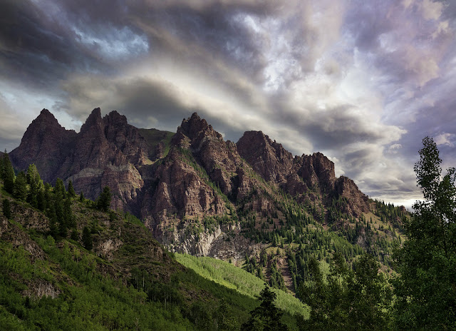
Sievers Mountain, Colorado

The summit of Sievers Mountain lies in Pitkin County, Colorado, in the United States, at a height of 12,786 feet (3,897 m). Located in the Elk Mountains, which are a subrange of the Rocky Mountains, Sievers Mountain lies 21 miles (34 km) west of the Continental Divide. In the Maroon Bells-Snowmass Wilderness, seven miles southwest of Aspen, White River National Forest manages the mountain. In addition to Willow and Maroon creeks, which are tributaries of the Roaring Fork River, precipitation runoff drains from the mountain slopes. 

As a result of the 4,000-foot rise in elevation within 1.5 miles of Maroon Creek, and the 1,950-foot rise within 1.21km of Willow Creek, there is significant topographic relief present. One of Colorado's most photographed places is Maroon Lake, which was formed when a landslide from Sievers Mountain slid into the valley and dammed West Maroon Creek. The United States Board on Geographic Names has officially adopted the mountain's toponym. 

Its climate is classified as alpine subarctic according to the Köppen climate classification system, which features cold, snowy winters and cool to warm summers. During the early spring, the area receives a dry period due to the altitude, so it receives snow in winter and thunderstorms in summer. Late July and August are the peak months for the seasonal monsoon, which brings afternoon rain, hail, and lightning.

Read More - The Canadian Mount John Laurie


Saturday 10 June 2023

The Wallaman Falls, Australia

Welcome to an awe-inspiring journey through the natural beauty of Australia! You should explore Wallaman Falls, an extraordinary waterfall that stands tall as one of the country's most captivating landmarks. Prepare to be mesmerized by its grandeur, enchanting surroundings, and fascinating geological features.

Discovering Wallaman Falls

Nestled within the stunning UNESCO World Heritage-listed Wet Tropics rainforest in Queensland, Australia, Wallaman Falls is an iconic destination that leaves visitors in awe. With a total height of 268 meters (879 feet), it proudly claims the title of the country's tallest single-drop waterfall. It's immense beauty and remarkable geological significance make it a must-visit for nature enthusiasts and adventurers alike.

Geological Marvel: The Creation of Wallaman Falls

To truly appreciate Wallaman Falls, it is essential to understand its geological origins. The falls were formed through the powerful forces of erosion and water flow over millions of years. The cascade is situated along Stony Creek, which meanders through an ancient volcanic basalt lava flow. This unique geological makeup, combined with the surrounding rainforest's rich biodiversity, creates a captivating landscape that appeals to both scientists and nature lovers.

A Symphony of Natural Wonders

1. Majestic Plunge Pool

At the base of Wallaman Falls lies a magnificent plunge pool, fed by the cascading waters. The pool serves as a tranquil oasis, providing a refreshing respite for those seeking relief from the tropical heat. Visitors can bask in the soothing ambiance while marveling at the falls' uninterrupted flow, creating a symphony of sights and sounds.

2. Lush Rainforest Wonderland

Wallaman Falls is enveloped by the enchanting Wet Tropics rainforest, one of the oldest and most diverse rainforests on Earth. Its emerald canopy shelters an astounding array of flora and fauna, making it a haven for nature enthusiasts. Wander along the well-maintained walking trails, and you'll be rewarded with encounters with unique plant species, vibrant birdlife, and, if you're lucky, glimpses of curious marsupials like the Lumholtz's tree-kangaroo.

3. Geological Splendor: Basalt Columns

Adding to the falls' allure are the striking basalt columns that flank its sides. These hexagonal rock formations, reminiscent of towering organ pipes, are a testament to the geological processes that shaped the landscape. Marvel at the symmetrical beauty of these columns, a natural masterpiece that further enhances the grandeur of Wallaman Falls.

Wallaman Falls: A Thrilling Adventure

For adventure seekers, Wallaman Falls offers an array of activities to get your adrenaline pumping. Embark on an exhilarating hiking expedition, trekking through the rainforest and ascending to vantage points that provide breathtaking panoramic views of the falls. Capture the perfect photograph or simply soak in the awe-inspiring scenery as you immerse yourself in nature's embrace.

Preserving the Pristine Beauty

The preservation of Wallaman Falls and its surrounding ecosystem is of utmost importance. Efforts have been made to ensure its protection, including the implementation of sustainable tourism practices, educational initiatives, and ongoing research. By visiting Wallaman Falls, you not only witness its majesty firsthand but also contribute to the conservation efforts that safeguard this natural wonder for future generations.

Plan Your Visit

To make the most of your visit to Wallaman Falls, consider the following tips:

  • Getting There: The falls are located within Girringun National Park, approximately 50 kilometers (31 miles) west of Ingham. Accessible by road, a well-maintained car park is available near the falls' lookout.

  • Best Time to Visit: Wallaman Falls is a year-round destination, but the wet season (December to March) showcases the falls in their full glory. However, be aware that heavy rainfall can affect accessibility during this period.

  • Safety: While exploring Wallaman Falls, prioritize your safety by adhering to signage, staying on designated paths, and avoiding prohibited areas. It's essential to exercise caution, especially near cliff edges and slippery surfaces.

Conclusion

Wallaman Falls stands as a testament to the captivating beauty and geological marvels that Australia has to offer. Its towering cascade, nestled within the lush embrace of the Wet Tropics rainforest, provides an unforgettable experience for those fortunate enough to witness its grandeur. By venturing to this extraordinary destination, you'll embark on a journey that combines adventure, tranquility, and an appreciation for the intricate wonders of our natural world.


Thursday 25 May 2023

Steens Mountain, Oregon United States

In the heart of Oregon lies Steens Mountain, a natural wonder. By providing in-depth information about the mountain's awe-inspiring beauty, rich biodiversity, and recreational opportunities, we aim to become your trusted source of mountain information. Get ready to discover Steens Mountain's secrets as we embark on a virtual journey. Nature's enduring beauty and the importance of preserving our natural heritage are exemplified by Steens Mountain. All who venture into its embrace are captivated by its majestic peaks and rich biodiversity. Experience the wonders of Steens Mountain's untamed landscapes on your own adventure. Make sure to tread lightly, leaving only footprints and taking with you memories you'll never forget.

The Wonders of Geology

A fault-block mountain with an impressive elevation of 9,733 feet (2,967 meters), Steens Mountain is an impressive example of geological grandeur. Visitors are captivated by the breathtaking views and the region's complex tectonic history.

Plants and animals that are unique

Nature enthusiasts and wildlife photographers alike are captivated by Steens Mountain's diverse flora and fauna. Its diverse ecosystems support a wide array of plant species, from alpine meadows adorned with vibrant wildflowers to ancient juniper trees.

It's not uncommon for birdwatchers to see raptors soaring through the skies, including the majestic golden eagle and the elusive prairie falcon. There are also bighorn sheep, pronghorn antelope, and mule deer roaming the rugged terrain.

The wilderness area of Steens Mountain

There is a protected area surrounding Steens Mountain and its surrounding landscapes, called Steens Mountain Wilderness. A pristine wilderness that spans over 170,000 acres (68,800 hectares) and protects the mountain's delicate ecosystems was designated as a national park by the United States Congress in 2000.

An extensive network of trails caters to all levels of adventurers within the wilderness area. Whatever your hiking style, Steens Mountain's trails offer something for everyone, from avid hikers to leisurely strollers enjoying the tranquility.

Recreation in the outdoors

There are a variety of recreational opportunities available throughout the year at Steens Mountain, which is a haven for outdoor enthusiasts. Take a look at some of the activities that attract tourists:

Backpacking and hiking

As a result of its rugged beauty and diverse landscape, Steens Mountain is a popular destination for hikers and backpackers. Those looking for day hikes or multi-day adventures will find trails in the region that cater to their needs. Observe cascading waterfalls and discover hidden alpine lakes as you traverse the mountain's ridges.

Viewing and photographing wildlife

Steens Mountain presents numerous opportunities for wildlife observation and photography for those who are passionate about wildlife. Witness the majestic beauty of bighorn sheep scaling rocky cliffs or pronghorn antelope gracefully grazing the plains. Be respectful of the animal's natural habitat and behavior by maintaining a respectful distance.

Stargazing and camping

Spend a night under the starlit sky on Steens Mountain to experience the serenity of the mountain. You can immerse yourself in nature's sounds and sights at several campgrounds, which provide basic amenities. Experience the wonder of the night sky as darkness falls and gaze up at the heavens.

Steens Mountain's preservation

Efforts to conserve

Steens Mountain must be protected and preserved. The mountain's ecosystems and cultural heritage are preserved for future generations by a number of organizations, governmental bodies, and local communities.

Practices for sustainable tourism

The adoption of sustainable tourism practices is essential when exploring Steens Mountain as a responsible visitor. To help minimize our impact, here are a few tips:

  1. Plants need to be protected, so stay on designated trails.
  2. Leave no trace of your visit by disposing of waste properly.
  3. Keep a safe distance from wildlife when observing it.
  4. Contribute to the economy of the region by supporting local businesses.

Read More  - The Spectacular Rimrock Trail


Saturday 13 May 2023

Mount Katahdin: The Centerpiece of Baxter State Park

Are you an avid hiker who enjoys a challenge and wants to take on one of the toughest hikes in the United States? Then look no further than Mount Katahdin in Maine. Rising more than a mile high, this iconic peak is the centerpiece of Baxter State Park, which offers a range of hiking trails, camping options, and scenic vistas for outdoor enthusiasts of all skill levels.👌 

Mount Katahdin is located in Baxter State Park, in the heart of Maine. It is the highest peak in the state and the northern terminus of the Appalachian Trail. The mountain is part of the rugged and remote Maine wilderness, which means hikers should be prepared for unpredictable weather and challenging terrain.

The climate on Mount Katahdin is cool and damp, with average temperatures ranging from the low 30s in winter to the mid-60s in summer. Rainfall is common throughout the year, and snow is common in the winter months. Hikers should be prepared for sudden changes in weather, including high winds, heavy rain, and even lightning strikes.

Mount Katahdin offers a range of hiking trails, each with its own unique challenges and rewards. The most popular route to the summit is the Hunt Trail, which covers approximately 5.2 miles and involves a vertical climb of more than 4,000 feet. This trail is recommended for experienced hikers only, as it involves scrambling over boulders and steep inclines.

Other popular trails on Mount Katahdin include the Abol Trail, which offers stunning views of the surrounding forests and lakes, and the Knife Edge Trail, which is considered one of the most challenging and dangerous hikes in the United States. This narrow ridge runs along the summit of Mount Katahdin, with steep drop-offs on either side. Hikers attempting this trail should be experienced and prepared for exposure to high winds and changing weather conditions.

Baxter State Park offers a range of camping options for hikers, including backcountry camping and designated campsites. Backcountry camping requires a permit and is only allowed in certain areas of the park. Designated campsites offer more amenities, including picnic tables, fire rings, and nearby water sources. However, these campsites can fill up quickly, especially during peak hiking season in the summer months.

Hiking on Mount Katahdin can be dangerous, especially for inexperienced hikers who are not familiar with the terrain and weather patterns. In addition to the Knife Edge Trail, there are other areas of the mountain that are steep and rocky, with potential hazards such as loose rocks and unstable footing.

To stay safe while hiking on Mount Katahdin, hikers should be prepared for changing weather conditions, bring appropriate gear such as sturdy hiking boots and rain gear, and carry plenty of water and snacks. Hikers should also avoid hiking alone and tell someone their itinerary and expected return time. In the event of an emergency, hikers should carry a map, compass, and whistle, and know how to use them.

Therefore, Mount Katahdin is a must-visit destination for hikers and outdoor enthusiasts who are looking for a challenge and want to experience some of the most beautiful scenery in the United States. However, hikers should be prepared for changing weather conditions, steep and rocky terrain, and potential hazards such as loose rocks and unstable footing.✌😗😃: 


Saturday 1 April 2023

Castlerigg Stone Circle: A Mysterious Megalithic Site in England

 Castlerigg Stone Circle is an enigmatic and ancient megalithic site located in the Lake District National Park in Cumbria, England. It is one of the most impressive and well-preserved stone circles in the country, and its origin and purpose remain a mystery to this day. In this article, we will explore the history, significance, and mysteries surrounding Castlerigg Stone Circle.

Introduction

Castlerigg Stone Circle is a megalithic site located in Cumbria, England. It is an ancient monument consisting of 38 stones arranged in an oval shape, and it is estimated to have been constructed around 3200 BC, making it one of the oldest and most impressive megalithic sites in England. The purpose of this article is to explore the history, significance, and mysteries surrounding Castlerigg Stone Circle.

The History of Castlerigg Stone Circle

The Construction of Castlerigg Stone Circle
The construction of Castlerigg Stone Circle is believed to have started around 3200 BC, during the Neolithic period. The stones used to build the circle were sourced locally, and their transportation and placement must have required a significant amount of skill and organization.

The Age of Castlerigg Stone Circle
Castlerigg Stone Circle is estimated to be around 5,000 years old, making it one of the oldest megalithic sites in England. The circle predates Stonehenge by about 1,000 years and is believed to have been used for a range of purposes, from ritualistic gatherings to astronomical observations.

The Evolution of Castlerigg Stone Circle
Castlerigg Stone Circle underwent several changes and additions over the years, with some stones being removed and others being added. In the early 20th century, several stones were re-erected to restore the circle to its original state.

The Possible Builders of Castlerigg Stone Circle
The identity of the builders of Castlerigg Stone Circle is unknown, but they were likely the prehistoric people who inhabited the area at the time. It is believed that these people had a complex society with sophisticated knowledge of astronomy, geometry, and engineering.

The Significance of Castlerigg Stone Circle

The Alignment of Castlerigg Stone Circle
Castlerigg Stone Circle is aligned with the surrounding mountains and landmarks, including Skiddaw and Blencathra, suggesting that it may have been used for astronomical observations or as a marker for the changing seasons.

The Connection of Castlerigg Stone Circle to the Sun and Moon
There is also evidence to suggest that the Castlerigg Stone Circle was used to mark the positions of the sun and moon. During the winter solstice, the rising sun aligns with the tallest stone in the circle, while during the summer solstice, the setting sun aligns with another stone.

The Ritualistic Significance of Castlerigg Stone Circle
Many researchers believe that Castlerigg Stone Circle was used for ritualistic purposes, including religious ceremonies and burials. The circle is thought to have been a sacred site for the prehistoric people who built it, and it may have been used as a place of worship or for communal gatherings.

The Role of Castlerigg Stone Circle in Prehistoric Society
Castlerigg Stone Circle is just one of many megalithic sites found across Britain and Ireland, and it is believed to have played an important role in the prehistoric society of the time. These sites are thought to have been a way for people to connect with the landscape and the natural world, and they may have served as a way to reinforce social ties and beliefs.

The Mysteries of Castlerigg Stone Circle

The Purpose of Castlerigg Stone Circle
Despite extensive research into Castlerigg Stone Circle, the purpose of the site remains a mystery. While it is believed to have been used for a range of purposes, from astronomical observations to religious ceremonies, its true meaning and significance are still unclear.

The Function of Castlerigg Stone Circle
Similarly, the function of Castlerigg Stone Circle is not fully understood. While it is believed to have been a significant site for the prehistoric people who built it, the specific role it played in their society remains unknown.

The Cultural Significance of Castlerigg Stone Circle
Castlerigg Stone Circle has also become an important cultural symbol, representing the ancient history and heritage of the British Isles. It has inspired writers, artists, and musicians, and it continues to capture the imagination of people from all over the world.

The Legend of Castlerigg Stone Circle
According to local legend, the stones of Castlerigg Stone Circle were once a group of dancers who were turned to stone as punishment for dancing on the Sabbath. While this story is unlikely to be true, it highlights the enduring fascination and mystery surrounding the site.

The Current State of Castlerigg Stone Circle

The Protection of Castlerigg Stone Circle
Castlerigg Stone Circle is protected by law and is a scheduled monument, which means that it is illegal to damage or interfere with the site in any way. The circle is also surrounded by a low fence to prevent visitors from climbing on the stones.

The Preservation of Castlerigg Stone Circle
In recent years, efforts have been made to preserve Castlerigg Stone Circle for future generations. The site has undergone several restoration projects, including the re-erection of some of the stones and the removal of vegetation that could damage the site.

The Tourist Attraction of Castlerigg Stone Circle
Today, Castlerigg Stone Circle is a popular tourist attraction, attracting visitors from all over the world who come to marvel at its ancient beauty and mystery. It is also a site of spiritual significance for many people, who come to meditate or hold ceremonies in the circle.

The Future of Castlerigg Stone Circle
As a unique and important part of Britain's cultural heritage, Castlerigg Stone Circle will likely continue to be protected and preserved for future generations to enjoy. Its mysterious history and significance.