Friday 7 February 2020

The Shona and Great Zimbabwe

Further inland from the coastal cities, other Bantu groups were establishing powerful empires based on one of the region’s most precious and profitable resources: gold. During the 800s, a Bantuspeaking people called the Shona settled in the valley of the Limpopo River in southern Africa. By 1000, they had moved onto an area of rich farmland between the Zambezi and Limpopo rivers. There, the Shona established a thriving empire. Shona Empire The empire that the Shona carved out of the grasslands of southern Africa consisted of numerous Zimbabwe’s, or settlements encircled by large stone walls.
The term Zimbabwe comes from a Shona phrase, dzimba dza mabwe, which means “houses of stone.” The ruins of about 150 such structures are scattered throughout the present-day southern African countries of Botswana, Mozambique, and Zimbabwe. Great Zimbabwe the largest of the Shona settlements was known as Great Zimbabwe. It was the center of the Shona empire.
The city and its surrounding area covered more than 100 acres and had a population of 10,000 to 20,000 people. Geography played an important role in Great Zimbabwe’s rise. The region was surrounded by huge plains that the Shona used for farming and cattle raising. Great Zimbabwe was also located near key trade routes.
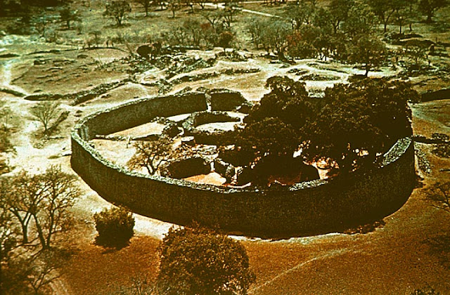
There are three main sections of Great Zimbabwe: The Valley Ruins, the Hill Complex, and the Great Enclosure. The Great Enclosure is the largest and most significant of these sections. Archaeologists think that the Great Enclosure was used as a home for kings and queens. From the air, the Great Enclosure looks like a giant necklace. Its outer wall is about 820 feet around and rises as high as 36 feet. An inner wall runs along part of the outer wall.
The two walls form a narrow passageway that leads to a 33-foot-high cone-shaped tower. The tower’s purpose remains a mystery. At one time, the enclosure contained elaborate buildings constructed of daga brick made from mud or clay. Shona builders cut stone blocks for the Great Enclosure’s walls from the granite hills around the city. They carved the blocks with such precision that nothing was needed to hold them in place. Many of the Great Enclosure’s walls are as smooth as a modern brick wall. The most elaborate walls probably date from the 1300s and 1400s.
Great Zimbabwe the largest remaining section of Great Zimbabwe is called the Great Enclosure. Its maximum diameter is about the length of a football field, and its walls are about 36 feet high. 1 Scholars believe kings and queens lived in the Great Enclosure, while farmers and workers lived outside. 2 A passage between the outer and inner walls leads to a 33-foot cone-shaped tower.
Historians speculate that it may have had religious purposes. Gold, Trade, and Decline Great Zimbabwe became an influential center of wealth and power due to the trade routes that passed through the city. The key product that traveled along these routes was gold. Gold was one of the main goods traded between Africa and the lands of India and China. Great Zimbabwe did not produce gold. However, it stood between the gold-producing regions to the west and the trading cities along the eastern coast. As a result, Great Zimbabwe’s leaders could tax those traveling the routes. They could also demand gold from the region’s less powerful leaders.
The city became the center of the international gold trade. Scholars estimate that at its peak, travelers carried more than 2,000 pounds of gold through Great Zimbabwe every year. During the 1400s, Great Zimbabwe began to decline. Some historians say that drought and the overuse of grazing land caused a resource shortage. Others argue that people left to take advantage of shifting trade networks. Whatever the reason, Great Zimbabwe was abandoned by 1500.


Product You May Interested
  1. Crush Food Cravings with Odd Water Hack and Melt 62lbs
  2. Flavor Pairing Ritual Supercharges Women’s Metabolisms
  3. The best Keto Diet Program
  4. Unlock your Hip Flexors, Gives you More Strength, Better Health & All-Day Energy.
  5. 21 Days Flat Belly Rapid Weight Loss System
  6. Fan Victor – The Ultimate Fantasy Sports Plug-in 
  7. 7 Instant Confidence Technique with Women Program

Palmerston Island - Place at The End of Earth

William Marsters
The geographically far-flung Palmerston atoll was first sighted by Captain James Cook and his crew in 1774. The intrepid Yorkshire-born mariner gave it a wide berth on this first encounter but chose in any case (either cannily or obsequiously) to name it after Lord Palmerston.

Returning three years later, and on his third voyage to these South Pacific parts, Cook and co. did indeed venture ashore seeking food and supplies. Thus, making Palmerston the only single island in the coral reef-bound Cook Islands to be graced by a visit of the great man himself. 

The island was then uninhabited but in earlier times it had experienced brief periods of native occupation and was already known to the Polynesians as Ava Rau – which translates as something like the Place of 200 Channels. But one name really dominates Palmerston, that of William Marsters.

At the last, all but three of the present residents of the island are direct descendants of Marsters. To call Palmerston a close-knit community is an understatement, to say the least. It is also an exceedingly small one: The population stands at just over sixty families, down from about 300 in the 1950s and 1960s.

William Marsters, however, did get the place off to a running start by fathering twenty-three children with his three Maori wives. Hailing from Gloucestershire (or by some accounts Leicester), this English carpenter and cooper had wound up on Manuae Atoll, near Aitutaki after sailing across the Pacific from California. Where he’d headed in search of gold in the rush of the 1840s.


Clearly a man given to taking a punt on a hunch, he accepted the position of caretaker of the island and sailed the 228 miles to it in 1863 with his first two wives. The third was acquired a short while later, and maybe even a fourth, too.

Once on Palmerston, he procreated, hunted the bosun bird, fished for parrotfish (still a prized local delicacy and the island’s chief export) and planted palm trees to produce coconut oil and gathered sea cucumbers from the lagoon. The house he built from the timber of shipwrecks still stands today.

And it was the only structure on the island to escape an appalling hurricane that swept everything else away in 1926. After a long tussle with the British government, William Marsters was eventually granted possession of the island by Queen Victoria in 1892 but died of malnutrition only seven years later after his coconut trees died of blight.

Technically administered by New Zealand, Palmerston has its own government and Marsters’ descendants were granted full ownership of the island in 1954. Only their relatives can reside on the island. What they have, certainly aesthetically, is as close to a Pacific island paradise as you can get – hurricanes aside.

Accessible only by boat and by a treacherous approach, this is a place of white sandy beaches, verdant palm trees and pandanus (a palm-like tree) and an abundance of coconut, taro, and breadfruit, all surrounded by a clear sea and a lagoon so plentiful with seafood that it serves as a kind of offshore kitchen, to be raided as the appetite demands.

That said, the numbers of parrotfish have dwindled so much in the last twenty years that intermittent bans have had to be imposed to help numbers recover. The islanders take pride in the peace of their surroundings and the gentility and order of their society.

Marsters was seemingly quite a severe and devout individual who schooled his offspring in Christian worship. The church continues to be the center of island life, and barter and exchange remain the main form of custom between islanders themselves. However, such a simple life over there, as no shops, no hotels, and no restaurants available. Most of the families are engaged with fishing occupation and collect rainwater for drinking water.

Drinking water is chiefly derived from rainwater and plumbing is primitive to non-existent: there are two toilets on the island. Their main freighter supply ship visits just twice a year, also bringing with it rice and similar staples to be traded for frozen parrotfish and other islands produce.

Slightly less isolated from the modern outside than it once was, Palmerston is on the internet. And electricity, previously rationed, is now available twenty-four hours a day, thanks to the installation of new solar panels in 2015. Home to the highest number of deep freezers per capita in the entire world.

The Palmerston Island especially welcomed this innovation, its people fed up with losing the contents of their freezers whenever the power failed. PIA (Palmerston Island Administration) and Cook Islands government take care of the administrative matters.

Moreover, fishing, tourism, copra, and bird feathers are the main economies. The basic and modern facilities are available on the island, like electricity, telephones stations, and cargo ships, but no airport. The island is full of coconut palms, pandanus, and native areas. The tropical climate, suits shellfish, parrotfish, and many other sea creatures.


Saturday 1 February 2020

The Kabayan Mummies Caves - Benguet Philippines

In ancient times, when life could be nasty, brutish and short. The doctor’s cures could be almost as deadly as any disease, and death was a constant presence. Since many unable to do much for the terminally ill other than speeding their eventual demise.
Sometimes doing so exceedingly brutally, our ancestors nevertheless set a lot of store on preparing for the afterlife. The death rituals of the Ibaloi tribe of Benguet Province in the Philippines were positively involved and more strikingly since they required the considerable and active participation of the dying, too.
For the Ibaloi, like the ancient Egyptians, mummified their dead, but they used a rather exclusive embalming technique. Their favored method of preservation was essential to cure the corpses with smoke and dry out the bodies until all that was left was a kind of desiccated husk of a human being. After that herb was rubbed onto the body. However, the process of dehydration started well before death.
The terminally ill, accepting their fate with a certain equanimity would drink beverages heavily laced with salt, a fatal poison if ingested in anything other than modest quantities. Once the person was dead, the body was washed down with herbs and tobacco smoke was blown over it.
And then into the mouth of the deceased by mourners before being hung above a smoldering fire for weeks on end. When mummification was complete the dead were ceremoniously laid to rest in oval-shaped wooden coffins carved with decorations and buried deep inside cave tombs.
The Kabayan Mummies are also famous as, Ibaloi Mummies, Benguet Mummies, Fire Mummies can find at Kabayan town in the northern part of the Philippines. Researchers believe that Kabayan Mummies were created by the Ibaloi somewhere 1500 AD in Benguet and buried in Caves.
However, some other Scientifics believe the process of mummification started in 2000 BC, shortly before a person died.  Eventually this brutal practice of that mummification over, since Spaniards colonized the Philippines in the 16th century.
Many mummies were stolen by Westerners as caves were not protected in the early 20th century. A nonprofit organization (Monument Watch) declared this place one of the 100 most endangered heritage sites in the world. Also, a small museum made in Kabayan, Benguet, where some of the fire mummies display for visitors. Also, more than two hundred caves unearthed here and out of 15 them having fire mummies.
This site is under consideration to declare the UNESCO World Heritage Site. Moreover, the burial caves in Kabayan town will collectively be called the Benguet Mummy Burial Caves or Mummy Burial Caves in Kabayan and Buguias. The locals are still fed fire mummies with chicken and gin, ensuring that they are having a good time life after death.


Product You May Interested

  1. Crush Food Cravings with Odd Water Hack and Melt 62lbs
  2. Flavor Pairing Ritual Supercharges Women’s Metabolisms
  3. The best Keto Diet Program
  4. Unlock your Hip Flexors, Gives you More Strength, Better Health and All-Day Energy.
  5. 21 Days Flat Belly Rapid Weight Loss System
  6. Fan Victor – The Ultimate Fantasy Sports Plug-in 
  7. 7 Instant Confidence Technique with Women Program

Friday 31 January 2020

No Man’s Land Fort, Portsmouth, England

No Man’s Land Fort is a sea fort as long Shunned Coastal Bulwark the in Solent Portsmouth, England.  The poet John Donne said no man is an island, but No Man’s Land Fort is an island of sorts. One of four iron and granite structures, it is set like tarnished stones in the murky tidal waters of the Solent, a mile or so off the south coast of England.
The main purpose of to build the No Man’s Land Fort is to give protection to Portsmouth and its harbor from French sea attack and bombardment. As perfect examples of robust, self-confident, enduring Victorian engineering as you could possibly find. They nevertheless speak volumes of the geopolitical anxieties of that age.
Like Spitbank, Horse Sand and St Helens, No Man’s Land Fort was erected between 1860 and 1880. It was in direct response to very real fears of a potential threat of invasion from across the English Channel. However, many believe the construction work of No Man’s Land Fort started in 1865 along with Horse-Sands, and St Helen's.
In 1860, the British Prime Minister, Lord Palmerston, established a Royal Commission on the Defense of the United Kingdom. Which recommended a substantial expansion of coastal bulwarks to protect naval ports such as Portsmouth.
Squabbles over their cost would delay their completion and by the time No Man’s Land was finally up and operating it was largely irrelevant. Both it and similar forts were popularly dismissed as ‘Palmerston’s Follies’. However, the First and Second World Wars were to dent such naysaying attitudes, as they were re-armed and manned as vital coastal defenses.
Therefore, decommissioned in the 1950s, No Man’s Land sat for years largely in a state of abeyance and used for coastal artillery until 1956. In 1960, it was decided to put on sale, but took 20 years to sold out by the Ministry of Defense in the 1980s and their parts fell into disrepair.
Since 2008, it has since been revamped as a luxury hotel and party venue, with a helipad, a wine bar, billiard room, swimming pool, laser quest arena and guest rooms. Most decorated in a nautical theme, with portraits of Lord Nelson a charming addition to some.
This is also called as “No Man's Fort” is 200 ft in diameter and lies 1.5 miles off the coast of the Isle of Wight, once housed more than 70 soldiers. In a 1972 serial The Sea Devils, many scenes were filmed at this fort. The Solent fort is capable of to accommodate 44 guests and 200 people at parties.


Product You May Interested

  1. Crush Food Cravings with Odd Water Hack and Melt 62lbs
  2. Flavor Pairing Ritual Supercharges Women’s Metabolisms
  3. The best Keto Diet Program
  4. Unlock your Hip Flexors, Gives you More Strength, Better Health and All Day Energy.
  5. 21 Days Flat Belly Rapid Weight Loss System
  6. Fan Victor – The Ultimate Fantasy Sports Plug-in 
  7. 7 Instant Confidence Technique with Women Program

Thursday 30 January 2020

Presidio Modelo – Cuba

Panopticon’, is a house of incarceration where the inmates are to be kept under constant surveillance by their goalers. Panopticon is a type of institutional place, where all prisoners to be observe under a single security guard. In its place of a model prison, it soon became notorious for unprecedented levels of corruption, cruelty overcrowding, and torture.
One of most chilling, fascinating and memorable place is five kilometers from Nueva Gerona. Now, almost roofless, fitting have been looted, apart from museum. The flat floor with only a central tower, that is monolithic pillar was a gun tower, here a single armed guard observed all prisoners, but they could not see him, and never knew if they were being watched.
The British philosopher, social theorist and prison reformer Jeremy Bentham first conceived this new type of prison in the 1780s. He was after being inspired by an observation platform at Prince Potemkin’s estate in Russia which allowed foremen to direct gangs of peasant workers. The system Bentham imagined would be both efficient to run, requiring fewer staff. x
Therefore, he believed, to improve the behavior of jailbirds into the bargain, leading them to emerge reformed at their end of their terms. Though it attracted the interest of the British government and the architect Willey Reveley was commissioned to draw up a plan for a building in 1791.
However, Jeremy Bentham hopes of erecting his own “panopticon” on a site beside the Thames in London. That is now occupied by Tate Britain, eventually came to nothing. But the concept of outlived its creator and has ever since shaped the design of prisons and much else besides.
One of the finest examples – however thorny an issue the use of that adjective may be in this context. So, a panopticon prison was Presidio Modelo, itself modelled on the infamously unforgiving Stateville Correctional Center in Crest Hill, Illinois, USA.
Presidio Modelo was inaugurated in 1926 on what was then called the Isla de Pinos – or Isle of Pines – off the southwestern coast of Cuba by Gerardo Machado y Morales. The country’s democratically elected president turned repressive dictator. Hence, it was completed a few years later.
Presidio Modelo was composed of four sixty-storey circular blocks. Each overlooked by a central watchtower, of four sixty-storey circular blocks. Also, each overlooked by a central watchtower, and the facility was accomplished of housing up to 6,000 prisoners.
Two of its most well-known internees were the future Cuban leaders Fidel and Raúl Castro. Who were held there after their attempted revolt against the Moncada Barracks in Santiago in 1953? Therefore, six years later, the revolutionary Fidel Castro, triumphant over the American-supported government of Fulgencio Batista.
Who had himself helped lead the overthrow of Machado, began using the same prison to house his own political opponents? But after episodes of severe overcrowding, hunger strikes and riots. Hence, Presidio Modelo was permanently closed in 1967. Since designated as a national monument, this “panopticon” has, ironically, become an object of interest to sightseers.
The visitors walked along the walls with mouth wide open to see this astonishing, creepy and fascinating building. Currently, this historical prions and museum are in disrepair but still well worth to see abandoned building to dig deep Cuban history. In spite of all facts, this spooky place needs some government attention to revive the precious pieces of history.


Wednesday 15 January 2020

Vilcabamba - Sacred Valley of Longevity

Nestled in a verdant valley tucked away in the Southern Andean highland is a location long revered by indigenous people. Vilcabamba has been termed the “sacred valley of longevity,” whose average inhabitants are said to live 100 years or more. The oldest has reported ages from 120 to 134 years old, yet these claims have not been substantiated scientifically. The native people live a simple, hard-working life and subsist on a diet of non-fatty foods. Vilcabamba is one of five places on earth where people live to 100 on a routine basis. 
The people’s longevity is also attributed to drinking the clustered mineral glacier water that hydrates the human cells. There are two rivers in the valley that flow all year. This mountain water contains valuable minerals and nutrients, and also creates deep and rich topsoil. These reasons, coupled with an excellent local climate, maybe why the local people of Vilcabamba live so long. The sacred valley of Vilcabamba is best known for the good health and longevity of its inhabitants, as well as a rumored lost treasure.
After the Inca Empire was crushed by the Spaniards, one last refugee group settled in an unknown location called Vilcabamba to wage guerrilla warfare against the European invaders. Spanish forces eventually found the refuge city of Vilcabamba and captured its ruler. In 1572, the “Inca problem” was finally put to rest when the Inca rebel Tupac Amaru was taken to Cuzco and executed. The last known flicker of Inca resistance was finally snuffed out. 
The Spaniards had hoped to discover even more vast treasures of the Inca Empire upon capturing Vilcabamba, but this was not to be. Few of the precious relics, en route to free the captured Inca ruler Atahuallpa, have ever been recovered. Much of the treasures of the Inca Empire are still rumored to be buried somewhere in the Andes. It was to find the lost city of Vilcabamba that Hiram Bingham set out on his famous expedition in 1911. He discovered Machu Picchu instead.
Getting to Vilcabamba
Bus transportation is excellent in Ecuador, and several buses per day run from the neighboring cities of Loja and Zumba to Vilcabamba. The town of Vilcabamba is located in the province of Loja, only 30 miles (42 km) south of Loja city. The drive from Vilcabamba to the disputed border of Peru is beautiful all 78 miles (125 km) of the way, but the border is impossible to cross. Visitors must return the way they came.


Product You May Interested
  1. Crush Food Cravings with Odd Water Hack and Melt 62lbs
  2. Flavor Pairing Ritual Supercharges Women’s Metabolisms
  3. The best Keto Diet Program
  4. Unlock your Hip Flexors, Gives you More Strength, Better Health and All Day Energy.
  5. 21 Days Flat Belly Rapid Weight Loss System
  6. Fan Victor – The Ultimate Fantasy Sports Plug-in 
  7. 7 Instant Confidence Technique with Women Program
Tuesday 7 January 2020

Morro Rock, California

Morroc Rock is one of 13 volcanic plugs lie between Morro Bay and Islay Hill in California. The Morrow Rock in Morrow Bay is one of biggest attractions in that area. The 581ft rock is protected as the Morro Rock State Preserve. The rock is composed of dacite, volcanic and petrified bird feces. Morro Rock considered a mysterious place to Salinan and Chumash tribes. In Spanish, Morro means “Crown Shaped Hill”.
It is believed that explorer Juan Rodriguez Cabrillo find the Morro Rock in 1542 and named it “El Morro”. The time goes on, and it becomes a favorite place for birds, made a nest on them, including gull species, cormorant, peregrine falcons. Sea otters and sea lions are commonly seen at Morro Rock. Also, one can see hermit crabs, coral, starfish, small fishes, sea cucumbers, bivalve mollusks, mussels, and much more.
On the surrounding of the bay, kelp plant forest, sea grass, tide pool plants, mosses, weeds, and lichens are surviving. So, it is an affordable place to spend some time there and observe the close-by nature. In winter, it is a popular place for bird watching, kayakers, kite flying, hiking, ocean-side golf, fishing, and surfers.
One of the most popular hikes in Sequoia National Park composed of classic 350 steps hike. You cannot climb to this granite dome as it is protected to falcons who made nest over there.  One of nine sisters of rocks extended from Morrow Bay to San Luis Obispo hills came into existence from volcanic activity. A causeway was built in 1933 with material blasted from rock slope to make all of them accessible.
Morro Rock Beach, or Morro Rock formed somewhere 23 million years ago from long volcanic plug extinct. The gorgeous natural setting offers picturesque scenes for photography. Almost 3.5 Southside round trip is a great opportunity to satisfying your day with a scenic view.
Many benches are available along the way to sit and relax for a while. The sunset view is so amazing, hard to miss if you are anywhere in the area. Moreover, one entertaining aspect of this area to find numerous squirrels approaching you without any problem.