Friday 3 August 2018

Houtong Cat Village

In Taiwan there is a village which was famous once for monkeys, then coal, and now cats and lots of them. Houtong, which means "monkey cave, is located in Ruifang District New Taipei. Houtong Cat Village was originally called ‘Kau-tong’ due to the existence of a cave inhabited by monkeys in the early days. The area was once a small mining town, famous for a well preserved culture surrounding its railway. The village good old days, the area produced more than 220,000 tons of coal per year. The largest coal output of a single area in Taiwan. In 1920, a purification factory was built, ultimately attracted myriad immigrants to the area. The town was gradually prosperous to 900 households to 6000 people.
Unfortunately the area was tending to decline in 1990’s due to decline in mining industry. The young generation begins to migrate to search for other opportunities. Eventually only few hundred inhabitants remained due to mining industry had died out. In 2008, a local cat lover Peggy Chien organized volunteers to start offering abandoned cats a better life. He was passionate cat lover to make things happen by posting cats images online. His passion turns in an overwhelming response from other cat lovers around the world.
The public fell in love with the adorable cats and the village once again flourishing. As the word spreading out, Houtong Cat Village became center for cat lovers. Since, number of cats living there increased got attention all parts of the world. Thus, reviving a declining village is transforming into a tourist destination. Interestingly some cats are sterilized and will have one of their ears trimmed as confirmation. Hence, this helps to keep check on the local population of cats, and also support in identify new cats which enter into the village. Black, 
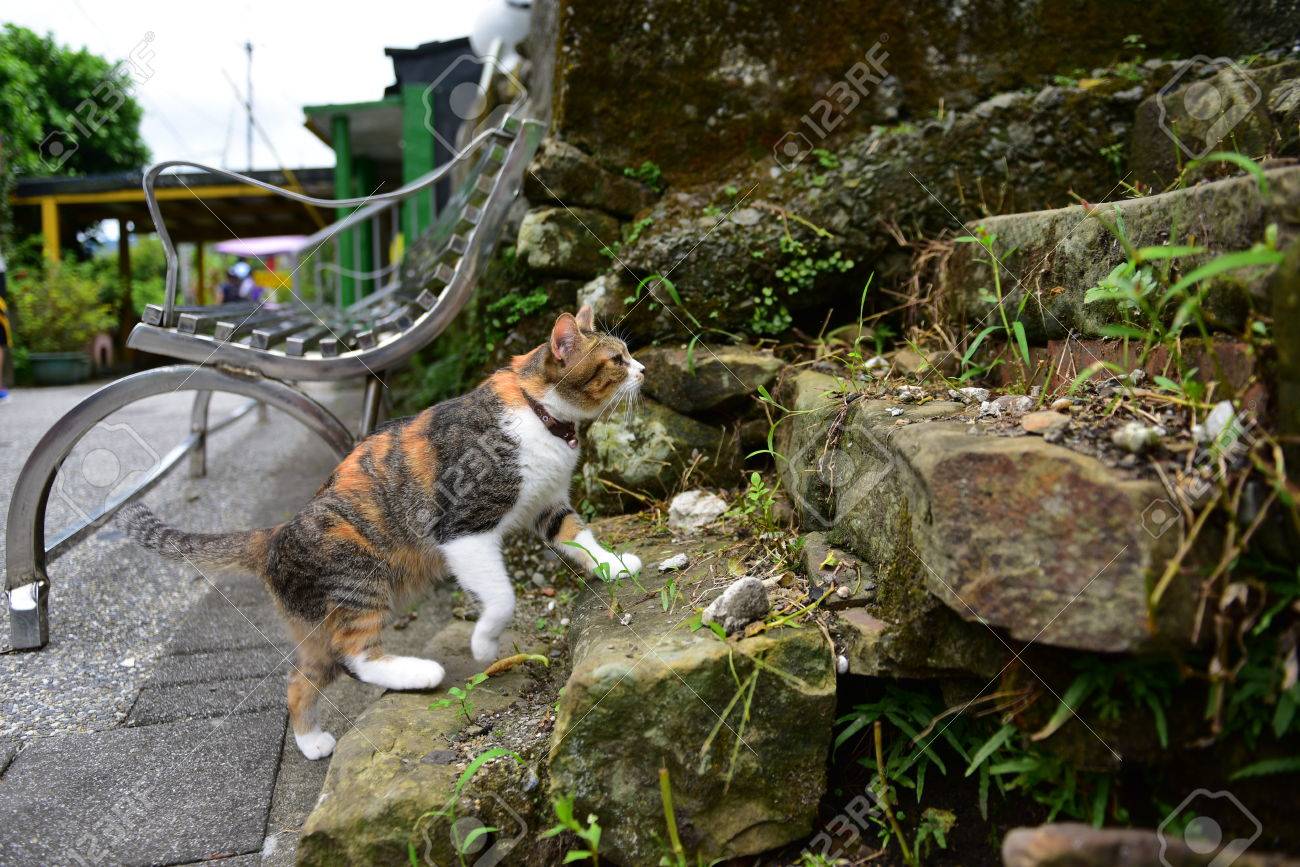
ginger, calico, tortoise shell, white and grey, fat and fatter, friendly and shy, there’re different cats of every wondrous kind in Houtong.
Though most of the cats hang out in the collection of cottages that cling to the hillside, they can be found roaming all over Houtong Village. Now, the Houtong Cat Village is prospering, featuring cafes, shops, relaxing places and restaurants catering to the many visitors who descend on this feline frontier every weekend. Cat lovers can see cats lounging in flower pots, loafing on shelves, padding up steps, jumping off roofs and spread out, sleeping, over stalls of kitty-themed souvenirs.
Houtong Cat Village is located near the origin of the Keelung River. The pristine, green waters of the river are accessible via steps. Drivers entering the town are greeted with a sign that reads 'A lot of stray cats’ here. Drive slowly. Moreover, A black covered “cat bridge” has been constructed above the busy railway, to allow safe passage for the cats. Houtong’s cats are remarkably good-natured, though they are usually being chased, petted and photographed by visitors. Source: CP
Obvious signage instructs visitors how to interact with the cats. The cats should be left alone unless they start contact, and they shouldn't be distraught or chased, the signs instruct. People who choose to feed the cats should clean up afterward, and flash photography is discouraged. The volunteers and doctors do regular neutering and injections to make sure the population is healthy and stable. And some people abandon their own pets there or even steal cats from the village.


Wednesday 1 August 2018

Volcanic Crater of Diamond Head Hawaii

Diamond Head is a famous volcanic crater of Hawaii, located on the eastern edge of Waikiki’s coastline. The most recognized landmark is known as Leahi (brow of the tuna) in Hawaiian. The crater was named “Diamond Head” by 19th century British sailors saw calcite crystals sparkling in the sunshine and thought they had found diamonds on the crater's slopes. These "diamonds" were actually shiny calcite crystals that had no value. In 1898, when the United States annexed Hawaii harbor defense became a main responsibility. One of the major defense forts, Fort Ruger, occupied the Diamond Head Crater. This broad, saucer-shaped crater is now a popular tourist place and hiking destination. Around 1.1 km hike leads to the edge of the crater's rim.

Diamond Head Hawaii has once been an active volcano, but hasn't spewed any ashes for more than 150,000 years. Diamond Head Hawaii has steep 99 steps, and a trip through the tunnel leading to them, as you climb the Diamond Head Trail near Waikiki. Further, geologists believe that the commercial diamond deposits were formed in the mantle and delivered to the surface by deep-source volcanic eruptions. These eruptions produce the kimberlite and lamproite pipes that are sought after by diamond prospectors.

Diamond Head Hawaii crater was formed during a single, explosive eruption that sent ash and fine particles in the air. Once these materials take place, they cemented together into a rock called tuff, creating this massive crater, and which is visible from the trail in the park. Most of the vegetation and birds were introduced in the late 1800s to early 1900s. The crater is 3,520 feet in diameter with a 760-foot summit. The volcano is a symbol of the worldwide recognition of the Hawaiian Islands. Many souvenirs from Hawaii and surf shop logos around the world bear the volcano's distinctive silhouette.

Because of its unique geological history, Diamond Head was declared a National Natural Landmark in 1968. Moreover, in the early of 19th century an observation deck was constructed at the summit to provide target sighting and a four level underground complex was built within the walls of the crater as a command post. A 580-foot tunnel was dug through the crater wall to provide easier access to the Fort. A battery of canons was located within the crater providing complete concealment and protection from invading enemies.

The observation deck and underground complex is now abandoned with the advent of radar but evidence of the command post is still present along Diamond Head Trail. A 1975 televised game show, The Diamond Head Game was set at Diamond Head. Diamond Head is an extinct volcano and one of the most photographed attractions in Oahu. In fact, it is a worldwide symbol of Hawaii and Waikiki, made popular in many movies, wall calendars and on postcards.
 Diamond Head Volcanic Crater hike takes 1.5 to 2 hours round-trip, and suggested that hikers bring adequate water, sunscreen and a hat. Although it is not very difficult, but never underestimate as hike is not a casual one. The mostly unpaved trail winds over uneven rock, ascends 74 steps, then through a tunnel and up another steep 99 steps. Further, the there is a small lighted tunnel to a narrow spiral staircase about 30 steps inside a coastal artillery observation platform built in 1908. From the summit above the observation platform both Waikiki and the Pacific Ocean can be seen in detail. Hence, if you want to hike at Diamond Head then it is highly recommended to come early to avoid the crowds and hot temperatures.


Tuesday 31 July 2018

The Doomsday Bunkers of South Dakota


No one can sense unforeseeable future. The nuclear war or biological warfare destroyed human being. The catastrophic war can killed most living beings and wipe out earth with radioactive fallout. Hence, in South Dakota, about 8 miles south of the town of Edgemont United States plan to save a small population of 5000 human beings in a remote underground shelter would be one of the few surviving pockets of civilization scattered throughout America. These Doomsday Bunkers are equipped with protection against everything from bombs to bio-hazards. The company's latest offering, the XPoint, is advertised as the largest 'prepper' community on Earth.

The plan is proposed by California based survival company Vivos. Few years back the company acquired 18 square miles complex called Black Hills Ordance Depot. Which is completely retrofitted with full amenities like an internal power generation system, deep water wells, biological, chemical and radiation air filtration systems, sewage discharge, and critical support equipment?

The Doomsday Bunker Design contains over five hundred nuclear-hardened concrete military bunkers, to some extent buried underground and protected by thick berms of earth, to resist a surface blast wave, as well as radioactive fallout. This area is strategically and centrally located in one of the safest areas of North America, at a high and dry altitude of 3,800+/- feet, well inland from all large bodies of water, and 100+/- miles from the nearest known military nuclear targets,” Vivos says on their website. Instead of windows, LEDs are placed inside the bunkers to simulate the different views of the outside world.

Therefore, every bunker is accomplished of withstanding a 500,000-pound internal blast. Each bunker is 26ft wide and 80ft long and can accommodate 10 to 20 people and the needed supplies for a year or more. The bunkers are separated from each other by an average of 400 feet in all directions that will work in their favor by providing security, protection and privacy. The Black Hills Ordnance Depot (BHOD) was constructed in 1942 and originally functioned as munitions storage facility during the Second World War and the Cold War period.

The survival bunkers were called Igloos because of their characteristic shape. The complex was once spread over 33 square miles and contained over 800 igloos and all the amenities of a well-planned town including living quarters for over 1,000 people, an Army hospital, a post office, church, shopping center, movie theater, including a theater, swimming pool, bowling alley and other mainstays of a small American town.

The survival bunkers igloos held all types of ammunition including chemical weapons and the deadly sarin and mustard gas. The history of World War II reveals, the site also held Italian prisoners of war. After the serving its object, the facility was closed in 1967. These bunkers were used by the Army in 1942 and built with reinforced concrete to withstand a 500,000-ton blast. Peoples can now lease the bunkers to be used as shelters in the wake of a disastrous event.
In case of any nuclear war, a viral pandemic or an asteroid strike at one-time upfront payment of $25,000 per bunker, plus a 99-year lease of $1,000 per year. Moreover, shared bunkers are also available at $7,500 per person. Aside from the facility at South Dakota, Vivos also has shelters in the state of Indiana in a Cold War era bunker adept of accommodating about eighty people. Moreover, Vivos is also building a luxury private shelter in an underground complex in Rothenstein, Germany. Source: Charismatic Planet


The Ultimate Natural Domes of Fabedougou


The amazing weathered rocks in the village of Fabedougou, near Banfora, in south-western Burkina. Faso Domes have an entirely different origin. Burkina Faso is a landlocked country in West Africa, covers an area of 274,200 square kilometers and its capital is Ouagadougou. The African country village Fabedougou has around 1,000 populations. The Natural Domes of Fabedougou very closely resemble to the famous sandstone towers of Bungle Bungle Range in Australia, hardly half a million years old.

The Domes de Fabedougou is a natural phenomenon of rock sculpted by wind and erosion like a stack of pancakes.  The sandstones comprising the Domes of Fabedougou are approximately two billion years old or Middle Proterozoic. But not the Domes of Fabedougou. Generally, a two billion year old rock would have been metamorphosed by the severe heat and pressure generated by the dynamic nature of the Earth’s crust.

In spite of being very old, these sandstones have been hardly metamorphosed and are astonishingly young looking. Keeping the time in mind, it is surprising that they are so well-preserved that some of these rocks even have ripples and dunes created by ancient water and wind flow. Tese Domes are actually ancient sand dunes. Geological experts say this entire area was once under a big ocean packed with free-flowing sediments. Some layers are extremely hard to others, so they were more protected from erosion.               

Therefore, as the time passes, that the sediments settled down and compacted to form sedimentary rocks of different thickness. Although, going pass a process of weathering and fracturing these rocks were molded into domes and craggy fingers pointing skyward. Differential weathering gives the rocks their layered looked, with each layer weathering at a different rate depending upon their composition.

The magnificent hauntingly beautiful Domes de Fabedougou undisturbed, and better for their desolation, bar local cows and herders. They are there for the climbing, and there are some easy ascents up the cracked sides of the domes, which sit side by side like a series of enormous urey iuloos.


Sliding Glass Rock, A Refreshing Area For Sliding Lovers


In North Carolina, near Brevard a sliding rock waterfall attracted thousands of visitors to take a slide all the way down the waterfall into plunge pool. Sliding Rock is a small slide type waterfall on looking glass creek. Sliding Glass Rock has a gentle slope of 60 ft long ending in an 8’ big deep pool at the bottom. On average, 11,000 gallons of water per minute power this natural wonder. People and families have been coming to Sliding Rock NC for some summertime water fun in the Blue Ridge Mountains. 

Sliding Glass Rock is one of most visited place in Pisgah National Forest. The crystal clear water is very cold but refreshing and popular for cooling off in the summer. The Sliding Glass Rock has long been used as a natural water slide for adventurous lovers. The two fun viewing platforms steps down to the pool and railing to support climb the rocks on the left side before sliding down. Tourists are allowed to take sliding down in a sitting position only. This is a heavily used recreation area which often fills to capacity. The best time to come in early in order to avoid rush which take place 12noon till 4pm.

No floatation devices like tubes, floaties or noodles are allowed. Only life jackets are permitted. The Sliding Glass Rock recreation area may close due to heavy rainfall, lighting is detected, and higher water levels. The area has been developed by the United States Forest Service into a famous recreation area. Moreover, parking is well available in a large lot above the rock and beside U.S. Highway 276. A restroom and changing room facility is available and a lifeguard is periodically on duty especially during summer weekends. You can slide during offseason times, but the water is colder than usual and there are no lifeguards or staff on duty.
In case if you are afraid of sliding down then there are a number of observation areas and decks with benches and seats, where you can relax and watch people sliding.  Because watching the children and people having a nice time to a great way to relax. If Sliding Rock is too busy, then it is recommended to take a quick drive over to Looking Glass Falls, which has a large swimmable basin at the bottom. Source: Charismatic Planet