Ghaziser Lake is a wonderful Point comes on the way to Babuser Top. Its a majestic lush green outfield and waterflowing in their own paths. Its a Stunning point to stay a while and enjoy the sheer beauty of Nature. The surrounding area is also covered with lush green trees and high mountains. You have put some extra efforts to get in down. The greenish patches are most integral part of this lake. Moreover, in July you can see pink flowers are bloomings in some part of this area, which are added more natural beauty. So, i would recommend to stay here and relish your time with your family and friends. Also, photographers can take some amazing snaps here. At this point, you will have no crowd and eating items. So be careful to have all stuff with you.
Monday 23 July 2018
Wednesday 4 July 2018
Trovants Stones of Romania
Trovants couldn’t believe they
are real. The mysterious living stones of Romania grow, when it rains and move
from one place to another without any support. The Stones of Costesti (a small
village) in Romania known as Trovants. These are type of sandstone concretion
that secrete cement and can at times appear to grow as if alive. These Trovants
are amazing geological phenomena consisting of stone core with an outer shell
of sand. The local people have different thought and claims; these are growing
stones after heavy rain, Trovants tend to appear with smooth and edgeless
shapes, cylindrical, nodular, and spherical.
They’ve strong believed that
these are type of sandstone concretion that secrete cement and can appear to
grow at times, as if they are alive. These are majestic growing rocks seems
identical look to sliding rocks of Death Valley. Trovants stones have puzzled
experts ever since their discovery. No one can say with definite how these
stones grow, and move. The perfect spherical shaped Trovants which sometimes
can be found are believed to be because of great magnitudes and durations of
the paleoearthquakes.
Trovants are Amazing Geological Phenomena When Mysterious
Living Stones Move and Grow?
Trovants is a synonym of
German term “Sandsteinkonkretionen”, which means Cemented Sand. In fact these
are mesmerizing living stones when cut had spherical and ellipsoidal rings
alike to the ones of tree trunk. There are numerous theories on Trovants
stones, as scientists are baffled by the phenomenon and some explaining the
origin and strange behavior of Trovants. There were few studies about origin of
these growing stones of Romania, and there are several hypotheses, some of them
even fantastical. Trovants were improperly considered as “sandstone concretions”.
It was found that there was no
mineralogical difference between these pseudoconcretions and the surrounding
sands, with no different nucleus inside them, and their cement is every so
often carbonate-type. Scientists have observed odd rings which resemble those
of the trees. And just like it is with the trees, the stone rings reveal the
age of Trovants. That’s why many believe Trovants are an inorganic form of
life.
The Trovants of Romania signify
diagenetic textures shiny paleodynamic conditions and correspond to precise
compactions of the sandy sediments holding locally solutions accumulated in the
sand. Therefore, during important seismic shocks and under the influence of the
internal cohesion forces tended to spherical forms. Also, the gravitation
force, seismic shocks, solution cohesion forces and the adhesion strength
between the sand grains and the liquid are believed to be involved in this
process. The hypothesis on the seismic origin of the Trovants is very well
sustained by several laboratory experiments. According to the
International Geological Congress conducted in Oslo 2008, “Trovanti” were improperly
considered as “sandstone concretions”.
There are various Trovants in
Romania which are even diversely shaped. As far as the growth of these “living
stones” is concerned, certain stones may gradually get slightly larger as the
result of absorbing water, in this case, the accumulations and deposits of
minerals cemented by waters rich in calcium carbonate seems to be the reason. Moreover,
there was a sedimentation basin in this area some six million years ago, and
the Trovants were not identical and complex aggregates of two ore more Trovants
can every so often be found.
Trovants stone are unusually
tough to break or smash. Generally, no one touches them, so they have the
chance to grow from little pebbles to enormous megaliths. There is a museum in
Romania, in which the fascinating stones are on display and sold as souvenirs. Even
you can plant a Trovants in your garden and wait for it to grow. The biggest Trovants
grow to more than 10 meters in height.
The growth of Trovants stones
in Romania is believed to happen when a chemical reaction sets in between the
layers of deposits and the mineral carbonates in the presence of rain
water. Hence, due to interesting ‘living
rocks’ that seem to grow, the site became a good tourist attraction for
Romania. To protect these unusual geological creations, the “Muzeul
Trovantilor” or Trovants Museum Natural Reserve is now protected by UNESCO.
Furthermore “Living stones” can also be found in Russia. A huge round stones
periodically pop up from the ground and start to grow in the fields of
Andreevka. So, if you ever go to Romania then you must have a stop at Costesti
and explore the fascinating mysterious formations that continue to amaze both
Scientists and tourists alike.


Monday 2 July 2018
Lot’s Wife, A Dramatic Inhabited Island
Lot's Wife is also called Widow's
Crag is a volcanic, deserted island located in the Philippine Sea. Lot’s Wife
lies about 650 KM south off the coast of Tokyo, and 76 KM from nearby Torishima
at the southernmost tip of the Izu archipelago, Japan. However Widow’s Crag Island
is just 0.01 km2 in area, but it reaches almost 100 meters in height. Its dramatic and isolated setting prompted discolored
sea water was observed about 500 m north of Sofugan, and the volcano was
reclassified as active by the Japan Meteorological Agency in 2003.
The Widow’s Crag island is a
basalt pillar with sheer sides, the only visible portion of a submarine
volcanic caldera extending 2.6 KM south-east at an average depth of 240 meters.
The sea-level portion measures is about 84 meters east-west and 56 meters
north-south, with a summit height of 99 meters. Lot’s Wife sides features having
several geological joints facing the water's surface.
Lot’s Wife is a biblical
figure who turned into a pillar of salt. Due to its exclusive shape and heavy seas it
is almost incredible to disembark on the island, though many attempts have been
made by rock climbers successfully in 1972 and 2003 and several accidents have
been registered. The Lot’s Wife is also known for the transparency of its
surrounding waters and abundance of fish, which makes it a popular scuba diving
spot. The only vegetation on the island is a few clumps of Poaceae, and the
island attracts a small number of seabirds for nesting.
On April 9, 1788, British merchant sailor John
Meares sighted what he came to describe as “the most marvellous thing” he had
ever set his eyes on, a small island he and the ship’s crew decided to baptize
as Lot's Wife, referring to the Book of Genesis 19:26. During the Pacific War,
Sofu Gan was used by US Navy submariners as a reference marker for calibration
of instruments as they entered Japanese waters. The uninhabited island was the currently
administratively part of Tokyo Metropolis. The Japanese name Sōfu Iwa “Soufuiwa”
is rather freely translated from English. This graticule is surely in the
running for the smallest nonzero land fraction of any graticule in the world.


Sunday 1 July 2018
Head Ballocki and Outdoor Adventure of Hunting and Fishing
The Balloki Power Plant is a 1,223 MW natural gas power plant currently under construction near Chunian, in the Punjab province of Pakistan. Groundbreaking was commenced by Prime Minister Nawaz Sharif on November 11, 2015, and construction is scheduled for completion by December 2017. The project will utilize regasified liquefied natural gas (RLNG) for fuel, with diesel as an alternate backup. A 40 kilometer long transmission line with a capacity of 500 kilovolts will also be constructed between the new plant and a grid station in southern Lahore. Baloki Headwork’s to Sulemanki Headwork’s Link Canal is just being used
to link up both Headworks. This is one of the famous fishing and
hunting outdoors adventure place. it is a great spot for fishing in
winter season.
Friday 29 June 2018
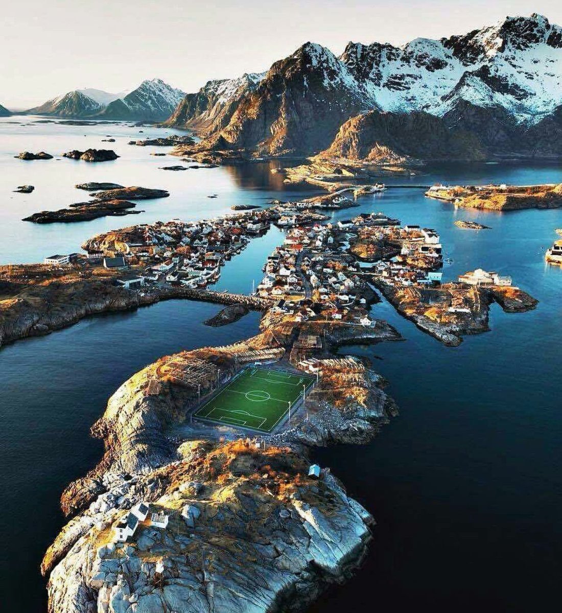
Henningsvær Stadium ! World's Most Beautiful Football Stadium
The Idrettslag Stadion is a small fishing
village of Henningsvær has been accessible by road, located two two small
islands off Lofoten, in Norway.
Henningsvær Stadium can hardly be called a football stadium; it has got
no stands just a couple of meters of asphalt poured around the field and is
used only for amateur football. The stadium itself provides synthetic field and
floodlighting for evening games, though of course it wouldn’t suffice for TV
broadcast. Atypically enough for a fishing village, the racks are the only
thing preventing the ball from landing in cold sea waters surrounding the
place. This tiny Norwegian sports venue grew largely in popularity on the
internet around three years ago.
The Henningsvær Stadium is enough to allow the
amateur club Henningsvær IL to train four groups of local boys! The stadium
location is extremely awesome, located on a rocky islet surrounded by stunning
views consisting of dramatic mountains and jagged peaks, open sea and sheltered
bays. The real treasure of Lofoten archipelago is visiting by travelers from
all over the world by appreciating the landscape. The stadium photo is viral in
media even FIFA has admired the ground location.
Therefore, the viral Henningsvær Stadium pitch
was laid by leveling the solid bedrock of the southernmost part of the
Hellandsøya Island, resulting in a very uneven landscape, decorated by vast
number of racks for drying cod. Moreover, around the perimeter of the field is
a strip of asphalt that serves both as the crowd stand and as car parking. The
stadium’s tiny capacity seems sufficient since the village of Henningsvær has
only about 500 populations. So if you are going you probably wouldn't have much
problem getting a game on this wonderful pitch. Finally, this football field in
Henningsvær in the Lofoten Islands is considered one of the most amazing fields
in Europe, and maybe even in the world. Source: CP


Monday 25 June 2018
Santa Elena Canyon, The Most Dramatic Place in U.S.
The lovely Santa Elena Canyon is most inspiring natural feature in Big Bend National Park. It is visible for more than 10 miles away cutting through the mountains via a deep narrow gorge. Santa Elan Canyon is quite a long distance 30 miles however a short nature trail enters its shady depths, eight miles west of Castolon, accessible by either Ross Maxwell Scenic Drive or the Old Maverick Road. Some are really quite winding and steep.
Santa Elena Canyon downstream is most popular area for one to three day trip, easily accessed by car. It is often considered most dramatic place has the tallest cliffs forming the canyon wall up to 1500 feet. The nature trail crosses Terlingua Creek, climbs several flights of ramps and stairs and then descends into the canyon along the Rio Grande offers one of the few remaining true wilderness river trips in the United States. Side canyons create interesting vistas, as well as exploration opportunities.
Santa Elena Canyon downstream is most popular area for one to three day trip, easily accessed by car. It is often considered most dramatic place has the tallest cliffs forming the canyon wall up to 1500 feet. The nature trail crosses Terlingua Creek, climbs several flights of ramps and stairs and then descends into the canyon along the Rio Grande offers one of the few remaining true wilderness river trips in the United States. Side canyons create interesting vistas, as well as exploration opportunities.
Moreover the area has an extremely dry and hot climate conditions, with temperatures up to 50 °C in summer with little rain. Further, there is a contrast between the desert and cold temperate ecosystems. You should keep in mind that during the rainy season, Terlingua Creek can flood and make access extremely difficult, so it is a nice idea to prior check with Park Rangers for current conditions. Local outfitters offer various trips when conditions allow, and river runners of intermediate or better skill level often go on their own.
Hence, water flow is normally adequate for river trips except during periods of prolonged drought. In addition, beware of flash floods that can raise the river level and flow rates very rapidly after rainfall in the drainage basin, even if it does not rain at the river. The low levels of water can prevent you from rafting along the canyon which is very popular activity here. Even a short distance is worthwhile the canyon feels much more remote and undisturbed once around the first bend when the entrance is out of view. Also stargazing is relaxing activity here as on the clearest nights, around 2,000 stars are visible to the naked eye. It is an outstanding place in North America for star gazing.
Santa Elena Canyon is majestic, towering canyon walls are much taller than in Colorado Canyon upriver a few miles. The scenery is remarkable, and there are numerous opportunities for wildlife viewing, hiking in shady side canyons and camping on spacious sandbars. The best way to see the canyon is by raft or canoe. Another scenic, little visited location is Fern Canyon 18 miles below Lajitas, a narrow tributary just two miles from Santa Elena Canyon. This is very narrow and has a pretty white limestone floor, polished smooth by the waters that sometimes flood down the ravine.
It is truly a majestic and gorgeous place to spend a few days. Due to the inaccessibility of the area it is generally best to be well prepared for any and all weather possibilities. The drive up to Santa Elena canyon absolutely breathtaking and it is amazing and once you park and start walking towards the canyon, your jaw just drops at the sheer majesty of it. Definitely a Big Bend must see/do hike. It is most photographed part of the Bing Bend National park. There is a massive boulder on the trail the size of a small house that is nice to sit under on a hot day. The rock formations rising on each side of the Rio are mesmerizing.
It is highly suggest visiting the canyon in early November through mid-March. Which is generally the best time to paddle the Rio Grande? The area may be very crowded during holiday periods or during the winter "snowbird" season, which is also the time most likely to have favorable paddling conditions. Summertime low-water conditions may be inadequate for rafting, but canoes can almost always navigate the river. Moreover entrance permits to Big Bend National Park are required for all vehicles entering the park for river access.
Also riverside camping is available just outside the canyon on the left side of river and right side of Mexican. Where ankle-deep Bermuda grass is covers the ground, making for a softer night's sleep. Firewood is scarce, if available at all, so carry what you need. Except for campfires, it is generally best to rely upon propane, butane or liquid fuel fires for cooking, personal hygiene and other general heating and cooking needs. Please keep in mind a fine may be imposed for camping in unauthorized areas.
Santa Elena Canyon location is in the middle of the continent and along a migration route, is ideal for bird diversity throughout the year. Northern species migrate here for the warm winter climate, while birds from the tropics range this far north to breed in the spring. One of major highlight is the Colima warbler, is a predominately Mexican species that only nests in the United States in the Chisos Mountains from April to September.
Santa Elena Canyon River Trip is more complicated in the last seven miles while entering the actual canyon. You can enjoy by paddling upstream from the Santa Elena Canyon Trailhead, just a few miles into the canyon, and then come back drown stream. There are a couple of rapids to watch out for, and the famed Rockslide can provide a challenge for even for experienced professionals. Santa Elena Canyon offers dazzling coves and remarkable side canyons that are a veritable feast for your eyes and your camera. So be sure to carry plenty of extra batteries. You may not want to leave Santa Elena Canyon.


Santa Elena Canyon River Trip is more complicated in the last seven miles while entering the actual canyon. You can enjoy by paddling upstream from the Santa Elena Canyon Trailhead, just a few miles into the canyon, and then come back drown stream. There are a couple of rapids to watch out for, and the famed Rockslide can provide a challenge for even for experienced professionals. Santa Elena Canyon offers dazzling coves and remarkable side canyons that are a veritable feast for your eyes and your camera. So be sure to carry plenty of extra batteries. You may not want to leave Santa Elena Canyon.


Wednesday 20 June 2018
Nankana Sahib Lake Resort
Nankana Lake Resort is located two miles from Nankana Sahib City,
in the heart of Punjab. The resort is located on the border of two old land
grants of the mid-15th century; Rai Bular’s Estate and the old Rajput trail
through authentic Punjabi villages approx. 90 Kilometers from Lahore.Nankana
Sahib Lake Resort is nice place to have one day picnic with your family
friends. It’s not far away from Lahore. Due to short time, i could not manage
to cover most part of point. However, it’s not a rush place expect local
holidays. If you want to go there, then choose the Saturday or week day.
The
entry ticket is Rs. 250 per head for schools, and Rs. 350 per head for
families. It includes: Entry to the Resort, Horse Riding, Ziplining, Boating,
Music Show, Mini Golf (for families only). Nankana Lake Resort follows an early
precedent set by Rai Bular, the pioneer who founded the original City of
Talwandi (now Nankana Sahib) that has attracted visitors to the area from all
over the world since 1457 A.D. The resort provides guests with the very best of
facilities in which to relax and get away from the urban noise.
Subscribe to:
Posts (Atom)