Tuesday 13 June 2017

The Burning Mountain of New South Wales, Australia


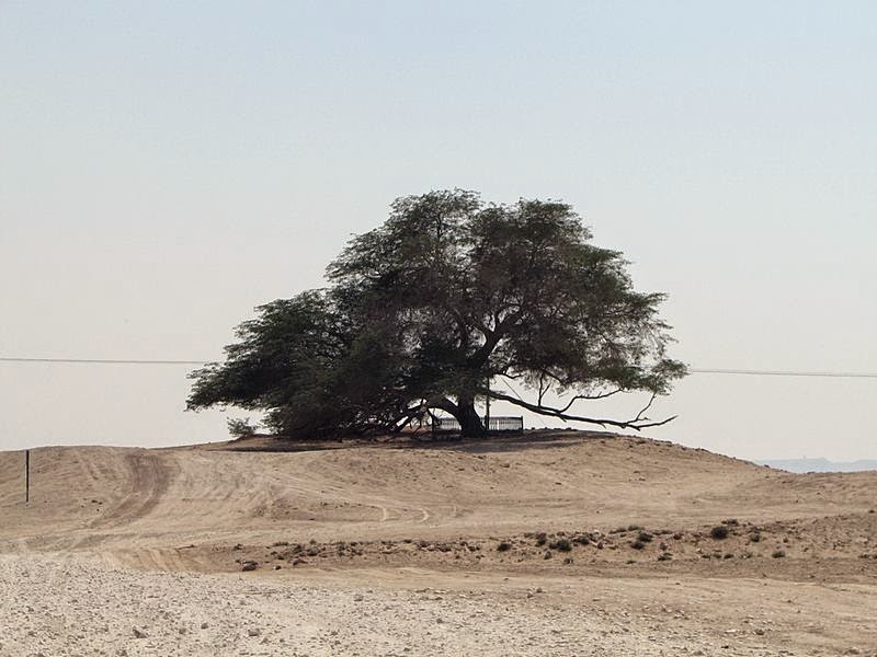
Burning Mountain, is also called “Mount Wingen”, is a hill near Wingen, New South Wales, Australia. It is located approximately 224 km north of Sydney just off the New England Highway. The mountain was discovered in 1828 by geologist T. L. Mitchell identified it as a coal seam fire. The name derives from a smoldering coal seam running underground through the sandstone, contained within the Burning Mountain Nature Reserve, which is administered by the NSW National Parks and Wildlife Service. 
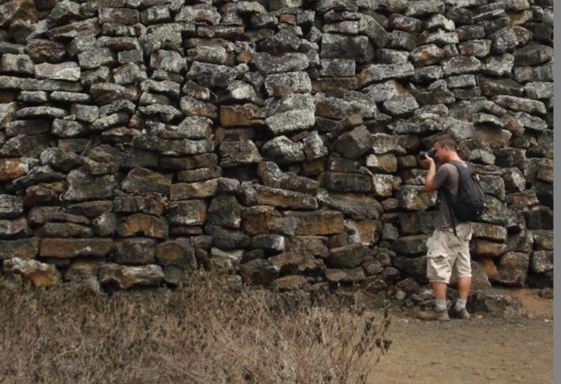
A trail runs from the parking lots to the site where smoke emanates from the ground. The underground fire is estimated that the fire has burned for approximately 6,000 years and is the oldest known coal fire.
The underground fire is estimated to be at a depth of around 100 ft. Many explorers and settlers to the area believed the smoke, coming from the ground, was volcanic in origin. The coal fire is usually moving in a southerly direction at a rate of about 3 feet per year. The combustion has caused soil discoloration and an uneven ground surface in the area. Coal seams are extremely common across the world, and at any time there’re over 1000 burning. They happen regularly in lesser-developed mineral rich countries, but are often put out within a few days or at most a month. Moreover, considering the average duration of a coal seam fire, Mount Wingen’s fiery longevity has become something of a marvel across the globe and sightseers have flocked to observe the sulfur-tinged smoke emanating from the mountain. Though Mount Wingen has enticed sightseers in droves, it has also caused huge ecological damage to the area’s vegetation. The View from high up is very pretty and very interesting history and how the heat changes the landscape.
The Burning Mountain, heat and toxic gases from the fire have left it rocky and jagged in parts, and the land has caved in. How the mountain was first set ablaze is a mystery. Burning Mountain Nature Reserve has management strategies in place to protect and conserve the values of this park. The scientific explanation for Burning Mountain is a gradually combusting coal seam and as it eats through the coal, rocks slip into the gap, triggering fissures and slumping at the surface level. Moreover, you must be sure to wear sturdy footwear and stay on the formed track. Not only that, but watch out for fossils, too: 200 million years ago, this whole area was covered by ocean.


The Tree of Life, Bahrain


In the desert of Bahrain, where there’s no groundwater source, quite inexplicably has been 400 years grows lonely acacia tree. It is also called "Hadzharat Al Haya" or Shajarat al-Hayah, which means "tree of life". It is located in Bahrain paradise gardens of Eden, has become the main attraction of Bahrain, tourists pulls feel involvement in the secret and touch the symbol of survival and triumph over circumstances. The tree stands on a hill in the Arabian Desert surrounded by miles of sand. There is not another tree as far as the eye can see; there is actually no life at all in the vast, arid desert. The average temperature in the region is 105 degree Fahrenheit often soaring to 120 degree, and bone stripping sandstorms are common.

The 400-year-old mesquite tree is growing in Bahrain, approximately 2 KM from the hill Jabal Dakhan. The tree height is 32 feet growing at a decent distance from all his fellows, in the middle of the desert, on top of 25-foot of a sandy hill. Hence, like all mesquite trees, Sharajat-al-Hayat pretty good feels dry conditions. No one is sure how the tree survives. However, researchers have speculated that the nearest possible source of water is an underground stream about two miles away and that the tree is somehow drawing water from that stream. Thus, the others say the tree has learned to extract moisture from breezes blowing it from the Persian Gulf or squeeze moisture from grains of sand. Others claim that the tree is standing in what was once the Garden of Eden, and so has a more mystical source of water.

Ideally, this could be attributed to deep into the ground leaving the root system; the roots went deep into the mesquite almost 50 meters. In this case the tree grows his longer roots, in order to reach though any groundwater. Moreover, extra-long roots do not explain why only one tree survived?  However, rumors about some miraculous bacteria residing in the sand somehow help the Tree of mine water; however, there is no official confirmation of this theory. The tree is a local popular tourist attraction, and it is visited by approximately 50,000 tourists every year. It is very prevalent because it is believed to be growing in the middle of nowhere, with no water source and has never been watered once throughout history. Moreover, Bahrain also has little to no rain throughout the year. As a result, it is also believed to be the site for cults practicing ancient rites. Thus, since October 2010, archaeologists have unearthed pottery and other artifacts in the vicinity of the tree, some of which may date back to the Dilmun civilization.


Monday 12 June 2017

The Wall of Tears, Ecuador


The Wall of Tears is an historical site just five kilometers west of Puerto Villamil on Isabela Island in the Galapagos Islands, Ecuador. A penal colony existed on Isabela from 1944 to 1959 and the penal colony was marked by abuse, and considered prisoners as slaves. One of the tasks entrusted to the prisoners, so they would have to do something. The wall construction was with volcanic stones, and Prisoners had to carry heavy stones from several kilometers. On this tour and during the construction of the wall, many fell due to insolation and lack of food. Moreover, many lives’ lost because the wall collapsed, and many prisoners were buried in makeshift graves along the way. The result of this construction is what nowadays is famous as the Wall of Tears. The wall is said to have been the cause of thousands of deaths during its construction, call it the wall of tears because it is said to emanate eerie cries and have a heavy energy surrounding it.

Isabela worked as a US military base but after the end of World War II, the forces withdrew. Therefore, the Ecuadorian government decided to use the, by then, remote island to take the most treacherous prisoners in the country and found what they called a penal colony. Thus the facilities abandoned by soldiers of the United States for that "prison" were used. But the horror of the story begins 1946 when it was decided, as a sentence, that criminals pay their verdict with hard labor. The Wall of Tears never finished being constructed , it really did not have greatly purpose being nothing more than to cause misery to hold prisoners in an activity, and it is an irresistible formation of about 100 meters long, 3 meters wide and 5-6 m high, which is now a site to visit the island Isabela.

Thus, definitely the history of the penal colony of Isabela and the Wall of Tears is not the gladdest history of the islands. The Wall of Tears, named for the suffering and pain of their builders, still stands all alone on Isabela Island, blocking nothing from anything and complementary each day with the beautiful landscape that grows around it. Peoples can actually walk up to the top of the wall and get an idea of how high it is and how easy it would have been to fall off with a little wooziness from the tropical sun. The penal colony on the island is long gone, but the memory of the cruelty inflicted their lives on.


Friday 9 June 2017

Calico, The Ghost Town of California


Calico ghost town located in the Calico Mountains founded in 1881, which was California's largest silver producer in the mid-1880s. The former silver mining town in San Bernardino County, California, had more than 500 mines. In 1890 the probable population of the town was 3,500, with nationals of China, England, Ireland, Greece, France, and the Netherlands, as well as Americans living there.
Calico produced over $20 million in silver ore more than 12-years. However, when silver lost its value in the mid-1890's, Calico lost its population.  The miner's packed up, loaded their mules and moved away vacating the town that once gave them a good living.  After that it became a "ghost town." In 1950’s Walter Knott purchased Calico architecturally restoring all but the five original buildings to look as they did in the 1880's.  In 1951, He installed a longtime employee named "Calico Fred" Noller as resident caretaker and official greeter.
Thus, in 1966, Knott donated the town to San Bernardino County, and Calico became a County Regional Park. In 1962, Calico Ghost Town was registered as a California Historical Landmark. Moreover in 2002, Calico vied with Bodie in Mono County to be accepted as the Official State Ghost Town. In 2005, a compromise was eventually reached when the State Senate and State Assembly agreed to list Bodie as the Official State Gold Rush Ghost Town and Calico the Official State Silver Rush Ghost Town. It was proclaimed by then-Governor Arnold Schwarzenegger to be California's Silver Rush Ghost Town. Nowadays, the park operates mine tours, gunfight stunt shows, gold panning, numerous restaurants, the historic, 2 feet 6in narrow gauge Calico & Odessa Railroad, and a number of trinket stores and lots of its original buildings are still standing.


Thursday 8 June 2017

Copycat Version of Taj Mahal in Bangladesh


Replica of Taj Mahal in Bangladesh is located 10 miles east of the Bangladeshi capital, Dhaka in Sonargaon. It is a scaled copy of the original Taj Mahal Unlike the original work on the building took only five years. A rich Bangladeshi film-maker, Ahsanullah Moni has announced his “Copycat version of Taj Mahal” project at a cost of about USD$ 56 Million in December 2008.  It was built 20 miles northeast of Capital Dhaka. The Replica of Taj Mahal caused bit complaints by some Indian officials. They believe copying Taj Mahal is unethical, and detract visitor from original one. The replica was unlikely to detract from the magnificence of the original and visitors were unlikely to mix up one with the other. A copy is a form of flattery for copyright infringement of the original 350 year old building; however, the Indian High Commission later accepted that the replica was unlikely to detract visitors from the original.

However Ahsanullah Moni said, how he built a replica of the Taj Mahal so that the poor of his nation can realize their dream of seeing neighboring India's famed monument. Therefore, construction work began in 2003, and he said that he came up with the idea in 1980 when he first visited the real Taj in Agra, northern India. He said that his homage had been built because most people living in Bangladesh where nearly half of the population exists below the poverty line and cannot afford to travel to India to see the real Taj Mahal. Everyone dreams about seeing the Taj Mahal but very few Bangladeshis can make the trip because it's too expensive for them.

Mr Ahsanullah Moni first visited the original Taj Mahal in Agra, India in 1980 and after that he has made six return trips. Therefore, he hired a group of architects and sent them to India to get the measurements. However, same marble and stone has used in Replica of Taj Mahal as same in the original Taj. The Replica was made with latest machinery, took less time. Otherwise it would have taken more than 20 years. More interestingly few people visit this site to compare the original Taj Mahal with the artificial one. That intention is to comparing would have very odd and irrational. It is suggested to enjoy & observe the Architectural property of this building rather comparing.