Friday 3 March 2017

Bay of Fires, Tasmania in Australia


The Bay of Fires, on the northeastern coast of Tasmania in Australia, is a big bay that stretches for about 30 km from Binalong Bay in the south to Eddystone Point in the north. In 1773, the British navigator and explorer Captain Tobias Furneaux noticed various fires along the coast, which led him to trust that the country was densely populated. Evidence of settlement by aboriginal people can still be seen along the coast. The name Bay of Fires 
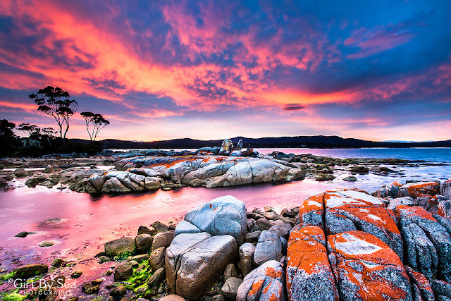
is associated by him, when he saw bay is characterized by white beaches, blue water and enormous granite blocks that are colored bright orange by lichens. The Bay of Fires is famous for its crystal-clear waters, white sandy beaches and orange lichen-covered granite boulders, the most popular conservation reserves. The conservation area is divided into three sections, with Anson's Bay dividing the southern and northern ends. A scenic view of the bay can be glimpsed by driving along the coast to The Gardens.
Perhaps, he named the bay after these fiery red rocks, no one knows? Moreover lichens are a mixture of algae and fungus that live together in a symbiotic relationship. The alga provides food by photosynthesis, though the fungus offers a protected environment for the algae. Thus, the combined life form has properties that are very distinct from the properties of its component organisms. Moreover, lichens are classified by their fungal component and are given the same scientific name as the fungus species in the lichen, regardless of what alga lives in the fungus.
The lichens responsible for the orange hue in the rocks of Bay of Fires belong to the family Hymeneliaceae. The beautiful color is contained in their thallus, which is the vegetative part of the body. Lichens are grouped by thallus type, since the thallus is generally the most visually protuberant part of the lichen. However in some lichens, the thallus is hard to distinguish. Which in result many lichens are remain unclassified? Aside from lichens, there’s a wealth of local wildlife to discover around the bay area, including corals birds, and the rich marine diversity that the reefs attract. Moreover, a wide range of activities are able to be pursued in the Bay of Fires area, including camping, beach activities, boating, bird watching, fishing, swimming, surfing, relaxing, walking, boat ramps, and rich marine biodiversity. But, be aware that Aboriginal middens “shell and bone deposits” are found in the sand dunes, hence do not disturb these protected sites.


Wednesday 1 March 2017

Devil's Den Cave in Florida


Devil's Den is a karst window, in which the roof over a subterranean river has collapsed, exposing the water to the open surface, near Williston, Florida. It is privately owned and operated as a SCUBA diving training and recreational facility. The cave was opened to the public as a dive site in the early 1990s. The water in the underground river is a constant 22 °C degree, cold weather water vapor rising from the surface of the river forms a noticeable plume above the entrance to the cave. It is suggested a chimney from Hell to early settlers. The opening to the surface was originally a small solution hole, through which visitors had to squeeze to reach the water. However, the opening was distended in the 1990’s to ease access. The cave shape is described as an “inverted mushroom” where water level expands up to 200 feet across. Thus, the water level in the cave has fallen along with the water table in the area.

The Devil’s Den is an awesome place that people have been using for thousands of years, as evidence by the many artifacts and fossils that have been found there. Moreover, there’re four underwater passages extend from the pool under the opening, from 5 feet to 90 feet under the surface of the water. The passage called chamber 3, 70 feet under water, contained animal and human remains and artifacts. The animal remains, which appeared to be associated with the human remains and artifacts, were from extinct (Pleistocene) species, including mastodons, ground sloths, camels, horses, dire wolves, bog lemmings, Florida spectacled bears, saber-toothed cats, and peccaries. Although, the water is clear and filled with fish, and loads of small minnow-like fish that are all around you. Hence, while snorkeling and look down deeper you can see larger fish swimming around water scorpion, and a snake trying to stay away from the humans.   


Tuesday 28 February 2017

The Strange Hoodoos of Goblin Valley State Park, Utah


This could be one of the weird and wonderful places in Utah, United States, is Goblin Valley situated in Emery County between the towns of Green River and Hanksville. In 1954, the property was acquired by the state of Utah and the Goblin Valley State Reserve was established. It was officially designated a state park in 1964. The Goblin valley, is about a mile across and two miles long, filled with thousands of strange hoodoos eroded sandstone rocks, carved by the wind and the water into shapes signifying mythical goblins and other phantasmagoric creatures. The most remarkable formations are three isolated hoodoos, huge in size, standing on top of a narrow ridge, enclosed by the flat, grassy land that extends for miles around. The strange hoodoos were formed by the erosion of the so-called “Entrada sandstone”, which was formed during the Jurassic period somewhere between 190 and 140 million years ago.

This area was situated next to an ancient sea. These strange shapes were created due to “Entrada sandstone” is made up of different kinds of sedimentary rocks having different levels of hardness, causing the rocks to erode at different rates. Therefore, the softer rock material eroded more rapidly, sendoff the harder rock behind in the shape of “goblins”. A trip to this strange and colorful valley is unlike any other place in Utah. The landscape, covered with sandstone goblins and formations, is often compared to Mars. Explore the geology, and camp among the nooks and gnomes. Moreover, the secluded Goblin Valley was first unearthed by cowboys searching for their cattle. In the late 1920s, “Arthur Chaffin”, the later owner of the Hite Ferry, along with his companions were searching for an alternate route between Green River and Caineville, when they came to an old point around 1 mile west of Goblin Valley. The Chaffin and his friends were awed by what they saw five buttes and a valley of strange, goblin-shaped rock formations fenced by a wall of eroded cliffs. It was given the name of Mushroom Valley by Chaffin. However, he returned to it in 1949 and consumed numerous days exploring the secretive valley and photographing its scores of intricately eroded rocks.

Moreover, vegetation is limited to hardy desert species that can endure blowing sand and hot dry surface conditions exist on a limited supply of water in the arid desert environment. Animals every so often travel several miles to find water or else wait for thunderstorms to provide moisture. Mostly Jack rabbits, kangaroo, scorpions, rats, kit foxes, pronghorns, midget faded rattlers, lizards, and coyotes are found within and near the park. The Goblin Valley is a most liked destination for film makers. Though Goblin Valley is a wonderful place to hike around and ogle at the goblins, however, take care to leave no trace and respect the space! If you ever plan to visit Goblin Valley yourself, the park offers a short naturalist-guided hike called "The Fallen Goblin," which is inspired by the incident.


Friday 24 February 2017

The Bizzare Shape Fantasy Canyon, Utah


Fantasy Canyon is a small roadside attraction of highly weathered rock formations in very bizarre shapes. Fantasy Canyon is the official designation of an area composed of unique erosional features it contains some of the most unique geologic features in the world. Fantasy Canyon is located about 25 miles south of Vernal, in northeastern Utah, United States. The place itself is famous locally as “The Devil’s Playground” and “Hades Pit” Hades is the lord of the underworld in Greek mythology. The Fantasy Canyon is a small area, actually not a canyon in reality, is packed with some of the most exclusively weathered rock formations bearing intriguing descriptive names such as “Flying Witch”, “Screaming Man” and “Alien Head”. During the Eocene Epoch, about 40 to 50 million years ago, the Unita Basin was well covered by a big lake called Lake Uinta.

Fantasy Canyon was located along the east shore of the lake, which is started to fill with sediments from the surrounding area and the once loose sands, silts, and clays were forged into sandstone and shale. Moreover, localized uplifting of this rock occurred, and this material started to erode. Therefore the different weathering conditions, the more durable sandstone endured while the more easily weathered siltstone and shale eroded away, acquiescent this remarkable scenery. The rare rock formations in Fantasy Canyon will eventually weather away and then topple and erode into sand, but fresh formations will appear as the topsoil washes away. Hence, the subtle formations are so brittle the area is referred to as “Nature’s China Shop.” This region is may be hard to get to, but one is rewarded by a short easy walk of less than one mile through a variety of fantastic formations. Though not a destination, this makes a great, short, roadside attraction before or after floating the White River. This is also a great place for kids to play and explore. Also, this is a gas field buzzing with a high volume of truck traffic and the road is fairly rough, so please drive cautiously.


Jasper Creek Venezuela


Jasper Creek is the name of a river and a series of cascades and waterfalls in the South American country of Venezuela. In the Gran Sabana Municipality of Bolívar State, in Venezuela, adjacent the town of Santa Elena de Uairén, flows a small stream. Japer creek bedrock of this stream is pure jasper, a semi-precious stone of mostly quartz and silica, with a strong red color due to the presence of iron. Jasper is used throughout the world to make jewelry and ornaments. The Venezuela native people traditionally used the jasper as striking stones to create sparks to start fires, so the creek is locally known as Kako Paru or “Firestone Creek”. In English, it is known by the name of Jasper Creek or “Quebrada de Jaspe” in Spanish. Jasper Creek is located about 25 km southwest of Mount Roraima. Jasper creek is naturally found in veins and cracks in volcanic rocks, and generally occurs only in comparatively small deposits, but in the Guiana Highlands, the intrusions of magma into the sedimentary bedrock have led to the formation of massive slabs of the stone that sometimes are hundreds of meters long. Moreover the stone slab of jasper over which the creek flows is more than 300 meters long, and the water is just a few inches deep.

Moreover the ripples in the water have carved long, parallel grooves and channels in the bedrock. In the shelter of this grooves, black algae grows that provides the riverbed a stripped appearance alike to tiger’s skin. The factual brilliance of the jasper is apparent only when sunlight shines directly on wet stone, writes “IbexEarth”. “When sunlight shines on the Firestone Creek, the brilliance of the cascades is exposed and the bedrock glows crimson and orange.” Jasper Creek is not the only creek with jasper bedrock; however a lot of other small streams throughout the Guiana Highlands cascade over layers of jasper or red hematite, but Jasper Creek are the largest and most remarkable of all. It is one of the most widespread tourist spot in Gran Sabana. Every year, thousands of visitors pay the visit to this unique place.