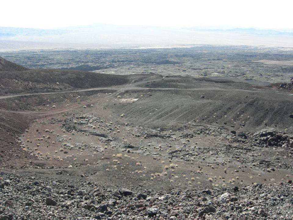
Monday 30 May 2016

The Pisgah Crater, California

Pisgah Crater, or Pisgah Volcano is a volcanic cinder cone in the Mojave Desert between Barstow and Needles, California United States. Pisgah Crater is in the Craters category for San Bernardino County in the state of California. The volcanic peak is about 2.5 miles, had a historic elevation of 2,638 feet. Although, mining activities has reduce the peak lit bit, but had a severe environmental impact. A Canadian based company “Can-Cal Resources Limited” presently owned the mountain specializes in exploration of precious minerals in California. The site of the Mount Pisgah Volcanic Cinders Mine, that produced pumice for commercial use and various cinder products, and sand was used to depict black sands of Iwo Jima in the film Letters from Iwo Jima. Moreover, the mountain top has been removed and scoured into an irregular shape.

Due to natural erosion and mining operation the crater has lost of must its original cinder cone shape. The base diameter of Pisgah Crater is 488 meters and stands 98 meters above the surrounding high desert terrain. 
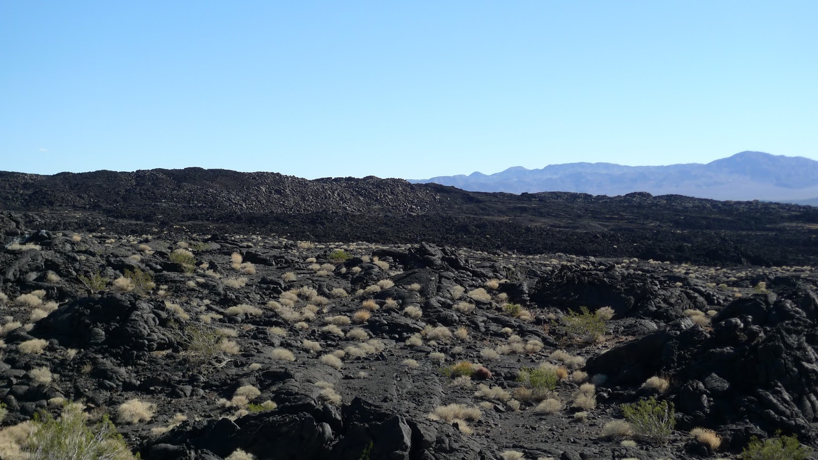
Furthermore, the mountain contains a large number of lava tubes, which are frequented by cavers and, these lava tubes in the area are a bit popular and with no trouble accessible destination for caving. However, no authentic data available when Pisgah Crater was last erupted, but many geologist, believes, Pisgah Volcano is the youngest vent of four cinder cones, may have been activity more than 2,000 years ago. Though, many others believe the last eruption could be occurred around 30,000 to 50,000 years ago. The volcano is basaltic, a reliable commonly used potassium-argon for dating purpose would be difficult anyway. A similar nearby Amboy Crater is interbedded with Bristol Playa sediments are somewhere 100,000 years old.
This volcano is very popular geology research site, not uncommon to find university classes and professional seminar groups around the mountain, geological survey activity also occurs at the mountain every so often. Moreover, the volcano erupted at least three times, produced porphyritic basalt, rocks from the first eruptive phase are almost aphanitic. The lava found around the volcano consists of a'a and pahoehoe, with considerable concentrations of olivine, plagioclase and rich amounts of gypsum can be found coating rocks near the cinder cone. The Pisgah Lave Field is located in a valley, with the Cady Mountains (Sleeping Beauty Mountains) to the north, looks like a lady lying on her back with her long dark hair trailing off to the east.

Therefore, the first eruption was a basaltic flow created extensive lava fields, and evidence of intrusive structures, it is believed the cinder cone was formed during this time. The second phase produced similarly extensive flows, while the third eruption produced substantial amounts of tephra. It is believed that most of the present cinder cone consists of pyroclastic material that originated from this final eruption. Well, On the Halfway up, there’s a dark hill called Sunshine Crater Cinder Cone distinctly older than Pisgah Crater, are off limits because they are within the 29 Palms Marine Base. Mount Pisgah name is derived from Bible, is described as a peak on Mount Nebo.

Sunday 29 May 2016

The Natural Bride of Virginia


Natural Bridge Virginia has been designated as a Virginia Historical Landmark and a National Historical Landmark, located in the beautiful Shenandoah Valley at the intersection of history, culture and natural beauty. The Natural Bridge is nestled between the Blue Ridge and Alleghany Mountain ranges and surrounded by over 58,000 acres of National Forest, have anything your adventurous heart desires. Natural Bridge Virginia is 15 miles south of Historic Lexington Virginia, 35 minutes north of Roanoke Virginia, and only 15 miles from the Blue Ridge Parkway milepost 62. The Rocks, limestones and dolomites indicate deposition approximately 470 million years ago. Although the process of formation of the bridge is not confirmed, but the thoughts proposed by different individuals have in common the importance of three elements: the southeast dipping of the strata, the capability of water to slowly dissolve carbonates and the existence of numerous fractures. 

Come see why Natural Bridge Virginia offers the best tourist attractions in Virginia. The magnitude and beauty of the Natural Bridge, compels many visitors to come to the area provides a unique, historic, picturesque and natural experience. One of our nation’s most iconic natural landscapes is now protected in perpetuity. Natural Bridge once ranked with Niagara Falls as one of the two natural wonders of the New World. The Natural Bridge was eventually eclipsed by the Grand Canyon and Yellowstone’s geysers but remains plentiful of a draw that other attractions have sprouted around it, including a wax museum, a safari park and Foamhenge, a plastic foam reproduction of Stonehenge.

Although, Natural Bridge was a mountain retreat, drawing countless visitors to capture nature-sculpted arch that soars high above cedar creek. Once among most visited natural wonders as one of 7 Natural Wonders of the Modern World. It is often cited as having a place among the enormous natural limestone arch. The arch was created when an ancient cavern collapsed leaving only the largest natural land bridge on the North American continent. Moreover, the other attractions in the area include a wax museum and a living history Monocan Indian Village. The beautiful trail under the bridge also furnishes an access to other attractions such as a recreation of Monacan Indian housing, Lace Falls, the "Lost River" and the Saltpeter Cave. Some researchers believe, the Natural Bridge would be the remnant of an underground river tunnel that diverted water to the south. Moreover the Natural Bridge was a sacred site of the Native American Monacan tribe, who supposed it to be the site of a major victory over pursuing Powhatans centuries before the arrival of whites in Virginia.

Well the 215-foot-long bridge was sacred to the Monocan tribe, and was revered by the American colonists. The site was surveyed in 1750 by a young George Washington, who allegedly carved his initials into the rock. Thomas Jefferson called Natural Bridge "the most sublime of nature's works" when he purchased 157 acres of land, including the bridge, from King George III of England in 1774. Perhaps the oddest parts of this natural wonder are "The Drama of Creation," a Biblically-themed evening light show that has been projected onto the bridge every night since 1920. The show is the longest continuously running light show in the US. Natural Bridge was one of the major tourist attractions of the new world that Europeans visited during the 18th and 19th centuries. Inviting tourists from all over the world took day trips from Natural Bridge on horseback or horse-drawn carriages to explore the countryside. 


Saturday 28 May 2016

The Hand of Desert in Chile

Somewhere in the Atacama Desert of Chile lies an astonishing monument “Mano del Desierto”, or the Hand of the Desert. In first look, it seems to be a science-fiction item, but actually it is a 36 feet high sculpture. However “Mano del Desierto” is a symbol of the contrasting ideas which shows how small, helpless and stranded humans are. The Chilean Artist Mario Irarrazabal has created this massive hand sculpture popular in his domain of sculpting hand made things. In fact weird as they may seem, and his efforts are acclaimed all over the world due to their innovative and emotion they express. 

The nearest town from this monument is Antofagasta around 75KM away. Nonetheless, visitors are crazy to see this marvelous effort of Mario Irarrazabal, and have catches surprise popularity throughout the year. Irarrázabal used the human figure to express emotions like injustice, loneliness, sorrow and torture and it is an easy victim of graffiti and is therefore cleaned occasionally.

However, it was built around nearly 25 years ago in March 28, 1992, seems just as if it was made of sand the sculpture is very resistant. The local organization “Corporaction Pro Antofagasta” support in construction of Hand, made by iron and cement. It’s a must visit place can be visited any time of year. His another popular works include an over-sized sculpture exploring the same idea, named "Monument to the Drowned" is located on Parada 4 at Brava Beach in Punta del Este, a famous resort town in Uruguay. 

Friday 27 May 2016

The Incredible Water Chemistry of Watling’s Blue Hole

The Watling’s blue hole is located on the Bahamian island of San Salvador. The karst feature Watling’s blue hole is formed by the erosion of limestone, actually made of calcium carbonate, a mineral that can dissolve in water especially in acidic water. When the limestone dissolves, it gives off carbonic acid, and even more able to dissolve limestone.

Once, the limestone dissolves the remaining part abruptly dissolves more, and result in formation of a deep blue hole around the spot where the limestone first began dissolving. In fact, Watling’s Blue Hole has incredible water chemistry, has no fresh water anywhere not even a tiny lens on top. Therefore, this hole must link all the way to the ocean to let salt water flow in constantly to dominate the system. The blue hole is sitting in the middle of rainy Tropical Island, indicating that the hole must be connected to the ocean by an underground tunnel. 

The Magical Spotted Lake, Canada


Spotted Lake is a saline endorheic alkali lake draws countless visitors from around the world located near the city of Osoyoos in British Columbia Canada. The Lake has rich of minerals such as magnesium sulfate, calcium and sodium sulphate and contains extremely high concentrations of minerals such as silver and titanium. In summer, Lake Water evaporates leaving behind colorful mineral deposits. The ameoba-shaped Spotted Lake, changes colors throughout the year and during the summer time divides itself into white, green, blue and yellow pools. It is said that the lake has the highest natural concentration of this mineral in the world. 

The colorful large spots appears according to mineral composition, Magnesium sulfate normally crystallizes in summer play a major role to spot color and remaining minerals in the lake harden to form natural walkways around and between the spots.  Nowadays, the spotted lake is surrounded by a fence to keep people off, but you can get a good view of it from the highway.

These minerals were used in the manufacture of ammunition during First World War. Chinese labour force skimmed up ton a day of salts from Lake Surface and shipped them to munitions vendors in eastern Canada. Later on, the site came under the control of the Ernest Smith Family for a term of about 40 years. The Ernest Smith attempted to create interest in a spa at the lake in 1979. 

Spotted Lake is a strange and significantly important site having great potential of commercial exploitation presently hype much controversy. The native peoples used the lake mud and water for the treatment of aches and ailments. Therefore, officially, Spotted Lake is on private land and therefore theoretically not accessible for close up observation. It is actually recognized to the First Nations of the Okanagan Valley as Kliluk. The spotted lake is surrounded by cairns rock piles often indicating graves. You cannot miss this historic landmark as you drive along the highway just west of the city. A lot of people stop on the side of the road for a longer look.