Thursday 19 May 2016

Pando: The World’s Oldest Living Organisms


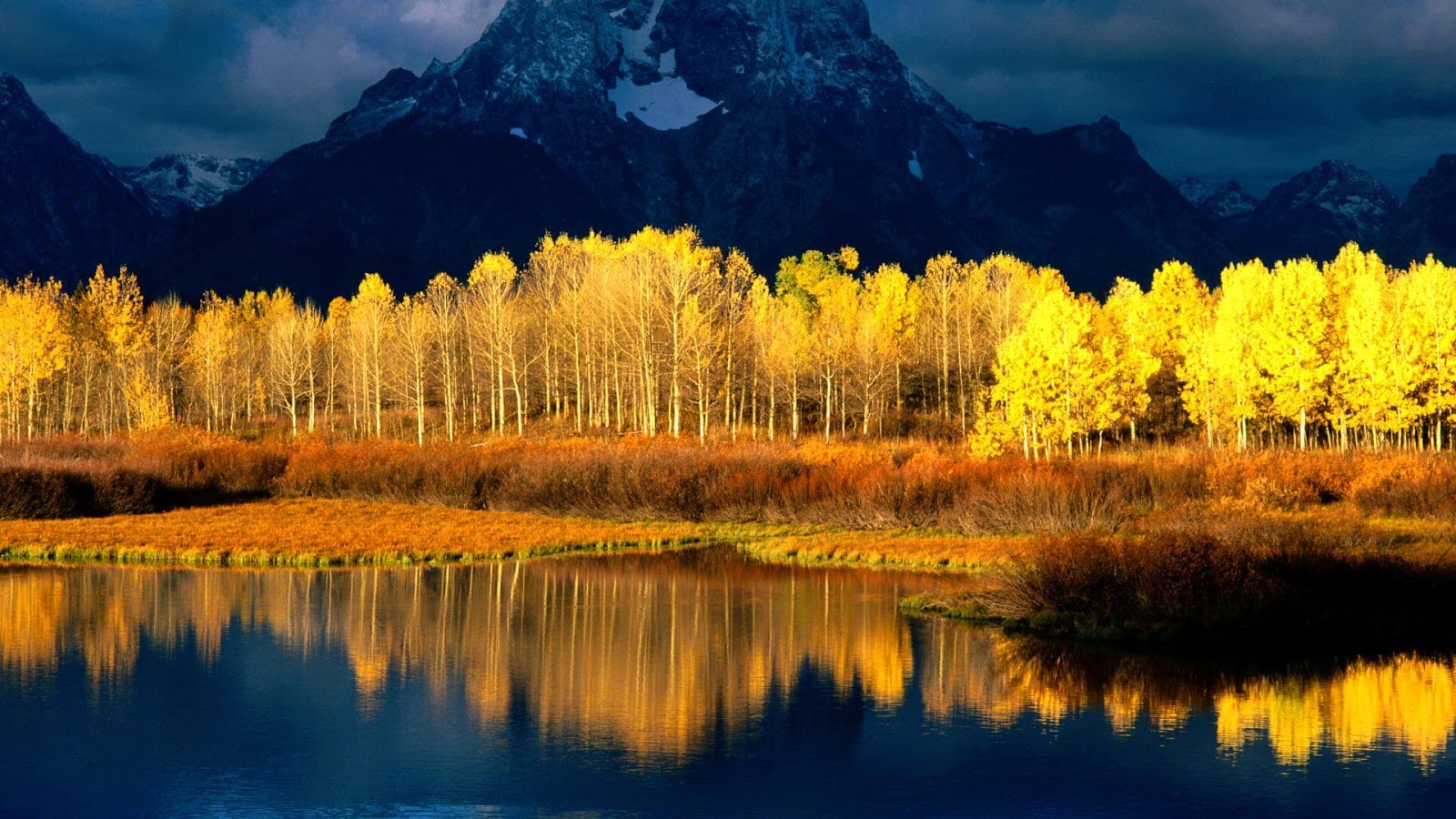
The Pando or “The Trembling Giant” is a massive grove of quaking aspens that takes the “forest as a single organism” metaphor and literalizes it. Although, the grove is a single organism, roughly 47,000 trees are genetically similar having single root system. However, various trees spread through flowering and sexual reproduction; quaking aspens normally reproduce asexually, by sprouting new 
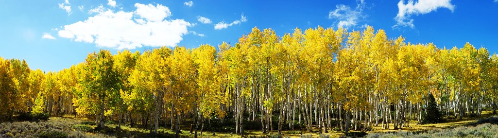
trees from the expansive lateral root of the parent. So, with their smooth white bark, intense black markings, and tall, thin trunks, aspens are some of the most striking and graceful trees, special varieties possess a very surprising quality. Each separate tree standing above the ground is actually part of one single, enormous plant. Pando is located one mile southwest of Fish Lake on Utah's Route 25, in the Fremont River Ranger District of the Fish-lake National Forest. The Pando aspen clone in Utah is hard to guess age and long-term research would have had to begin when humans were starting to emigrate out of Africa. However, individual trees have a lifespan of somewhere between 200 to 220 years, but clones considered as a single entity can sprawl for acres, all descended from one original tree, and are able to reproduce indefinitely.

Actually, the individual trees aren’t individuals, but their stems of massive single clone. Pando was once believed the largest organism in the world spanning 107 acres and weighing 6,615 tons making it the heaviest known organism, now usurped by thousand acre fungal mats in Oregon. Furthermore experts are also not sure about organism’s age with the level of precision found in tree rings. However, some believes Pando is massive organism and its age is more than one millions years old, could be easily called world’s oldest living organisms. Moreover, the quaking aspen is named its leaves, usually stir without any trouble even in a gentle breeze enable to produce a fluttering sound with slightest provocation. This has impact on Pando’s, multiplied thousands of thousands trees prevalent in massive acres unnerving, giving a real sense of life to the ancient dying, trembling giant. Other things, which can be oldest living organisms, possibly larger fungal mats in Oregon, the ancient clonal Creosote bushes, and strands of the clonal marine plant Posidonia oceanica in the Mediterranean Sea.

According to some ecologist, the future of Pando organisms is in danger due to mature stems is regularly dying from the eternal problems of pests, diseases, drought and regenerative roots of organism are under attacks. Although, The Western Aspen Alliance has been studying the tree in an effort to save it, and the U.S. Forest Service is doing experimenting with numerous five acre sections of it to make an effort to find a means to save it. The roots systems which are mainly responsible for Pando’s resilience are not nourishing. Therefore, ecologists are suggesting of juvenile and young stems to replace the older trunks, blaming overgrazing by animals. The Pando is slipping away due to lack of new growth to replace the old. In fact, the Trembling Giant is vulnerable to a catastrophic, abruptly withering and shrinking. The clone now recognized as Pando was actually discovered in 1968 by researcher “Burton V. Barnes”, who had described Pando as a single organism based on its morphological characteristics alone; molecular techniques and methods developed since that time have largely substantiated those conclusions.

Pando’s needs ideal circumstance of colonizing the area under wet climate into which Pando was born was markedly different from that of these days. Pando is thought to have grown for much of its lifetime under ideal circumstances: frequent forest fires have prevented its main competitor, conifers, from colonizing the area, and a climate shift from wet and humid to semi-arid has obstructed seedling establishment and the accompanying rivalry from younger aspens. Moreover, during intense fires, the organism survived underground, with its root system sending up new stems in the aftermath of each wildfire. If its postulated age is correct, then it may have been as many as 10,000 years since Pando's last successful flowering. The special properties of the quaking aspen, fascination with the beauty, complexity, and continuing mystery of this tree perhaps save clones like Pando from a destiny as firewood.

Wednesday 18 May 2016

The Extinct Amboy Crater of California


Amboy Crater is cinder cone type of volcano located in the Eastern Mojave Desert in San Bernardino County California. This is extinct North American crater, rises more than 70 square kilometers lava field in Southern California and about 120 KM between Barstow to the West and Needles to the east and 2.4KM south of historic U.S. Route near the town of Amboy. Amboy Crater was recognized for its visual and geological significance, and an excellent example of a very symmetrical volcanic cinder cone. The crater is projected more than 80,000 years old and formed in layers of mostly vesicular pahoehoe during the Pleistocene geological period. 

Amboy Crater is National Natural Landmark was designated in May 1973. The crater interior has Lava Lake, which flows as old as Amboy Crater. The Amboy Crater blankets the surrounding area, and last recorded eruption was more than then thousand years ago. Moreover, Amboy Crater is 944 feet above sea level and 250 feet above surrounding basalt lava plains. The Amboy Crater is popular sightseeing area due to its scenic beauty for all travelers. Amboy Crater is extinct volcanoes along the entire route 66, could boast traffic that they had climbed a real volcano. Therefore, visitor’s numbers have decreased due to construction of interstate 40. But in the past few years, the tourist’s numbers are increasing again with the adjacent Mitchell Canverns, Mojave National Preserve, and renewed historical tourism interest in old route 66. 

 It is highly recommended using Western Cone Trail to reach the volcano peak’s rim, a very steep and rocking hiking trail. There’s parking area available, a much needed shade and open picnic tables along with public restrooms. The area is apply regular desert precautions, need to high alert of rattlesnakes and old military explosives. So it is suggested to have a hat, sunscreen, sturdy shoes and sufficient drinking water. The Amboy Crater is flat in general appearance, mainly covered with light colored clay, giving the impression of miniature dry lakes. If you want to visit this part of area, then it is suggested to visit in spring months starts from March till May, because desert life is on peak due to wildflowers, blanket of desert primrose and sand verbena offers an excellent for photography. Moreover, the magnificence landscapes found at Amboy Crater have attracted the filming and research industry. Moreover the Needles Field Office is encouraging educational groups and organizations to contact the office prior to their trip to ensure all facilities are available. 

Monday 16 May 2016

The Murud-Janjira Fort

The Murud-Janjira Fort is situated on an oval-shaped rocky island in the Arabian Sea, near the coastal town of Murud, 165 km south of Mumbai, India. Once the stronghold of the Abyssinian Siddis, who played an important role in the history of Mumbai, later in the 17th century, Janjira is regarded one of the strongest marine forts in India, and the only unconquered one along India’s western coast. The fort was famous for its three gigantic cannons, weighing over 22 tons each that were feared for their incredible shooting range. Therefore, the words “Janjira” steal from Arabic word “Jazeera”, which means an island. Murud is a Marathi word for the Siddis, an ethnic group originating from Abyssinia, a historical nation in modern day Ethiopia.

So Murud-Janjira basically means “island of the Siddis”. The fort was originally built not by the Siddis, but by a local Maratha-Fisherman Chieftain, Rajaram Patil, in the 15th century, albeit on a smaller scale. At that time the fort was recognized as "Medhekot” and was built to defend his people from pirates and thieves. This was captured by a general of Nizam Shah of Ahmednagar, and later strengthened by Malik Ambar, the Abyssinian-origin Siddi regent of Ahmednagar kings. From then onward, the Siddis became independent and extraordinarily influential as autonomous state, and the fort continued to be occupied by them. Throughout history, several attempts were made by the Portuguese, the British and the Marathas to pacify the power of the Siddis, but badly failed.

However, the great Maratha leader Chhatrapati Shivaji tried unsuccessfully to scale the fort’s 40-feet high granite walls. Although in ruins now, Murud-Janjira was a full-fledged living fort in its heydays with all required facilities such as palaces, quarters for officers, mosque, fresh water tanks, etc. The outer walls and all the rounded bastions of the fort are still intact. Other attractions for history buffs include the Palace of the Nawab, because this lavish cliff-top mansion built by the former Nawab of Janjira commands a panoramic view of the Arabian Sea and the Janjira sea fort. Moreover another special attraction of this fort is three gigantic cannons named Kalalbangdi, Chavri and Landa Kasam. These cannons were said to be feared for their shooting range, another gate to the west is sea-facing, called 'Darya Darwaza'.

Friday 13 May 2016

The Dizzying Paiva Walkways in Portugal


An incredible 8-KM walkway along the bank of Paiva River in arouca, Portugal stretches across the sprawling natural terrain.  The wooden walkways that cling to the mountain side a winding staircase that leads to the top of a huge hill, providing a stunning 360° panoramic view of the terrain, and an extremely narrow wooden bridge that spans across the river surrounded by soaring cliffs, sweeping views of waterfalls, quartz crystal deposits, exotic fauna and flora and abundant natural vegetation. The ‘Paiva Walkways‘was opened in July 2015, and route begins from the river beach Areinho and finish at another beach Espiunca. Last year in September, the devastating wildfire damaged over 600 meters of wooden walkways, but authorities has done restoration work quite briskly and reopened for public.
The Paive Walkways completed by Arouca Municipality and engineering company trimetrica. The Paiva walkways ismore than merely a simple walk in nature, this unique experience is an infrastructure that interferes as little as possible with the surrounding environment and continues along the topography, with rest stops and strategic panoramic points positioned to admire the view. Hikers are bestowed with stunning natural views to capture the route dizzying directions, documenting different parts of the path and its relationship to the marvelous landscape. 

Thursday 12 May 2016

The Ancient Shumen Fortress of Bulgaria


In Bulgaria, Shumen Fortress is one of most popular landmarks, three kilometers away from center of Shumen. The ancient fortress with historical linkage to a village is situated in the Shumen Plateau, perhaps first built by Thracians and later reconstructed by Romans, Byzantines, and Bulgarians. Shumen Fortress conquered and demolished various times until 1444, when it gives to new life. It is thought; the first fortification built 3200 years ago, probably one of the oldest fortifications in Bulgaria. Therefore, during first Bulgarian Kingdom 680D to 1018D the fortification played a vital role due to its closeness to the Pliska and Preslav. However the second Bulgarian Empire 1185 to 1396 the Shumen became a prominent economic and culture center of the stats. Many legends believe Ottoman demolished the fortress after conquered it in 1844. 

But archaeological research reveals it was burned and demolished by crusaders led by Vladislav Varnenchik during 1434-1444. The Polish-Hungarian descent had attempted an attack on the Ottomans which has proved to be very calamitous as he was killed during the Battle of Varna. Following this battle the fortress was looted and gutted and the Ottoman rulers eventually abandoned the fortress completely. The First Empire has revealed during archaeological excavations carried out since 1957, a village dating back to the Iron Age to the 4th century BC.  In eastern and central parts of Europe there is hardly any one area where a nation’s history as a whole, through over one thousand years, is concentrated to the same degree as in Shumen.

The Shumen fortress represents a substantial part of the country history and remains of Fortress most thoroughly studied in Bulgaria, reveals information about the life and military customs of Bulgarians. The remains consist of Roman bath, vessels, pottery, adornments and coins were found. In 2012, restoration work was started with financial assistance provided by EEA (European Economic Area) and partially completed in 2015 covered walls of the fortress, creating tracks for walking around the fortress, and also building turnstiles. 

These days, Shumen Fortress has converted into popular tourist destination along with open air museum. Tourists are attracted by rebuilt of tower of fortress offers a stunning view of the Shumen City. The restoration works and other infrastructure created to boost tourism are artistic lighting and equipment for temperature and humidity control, publicity brochures and overall management aspects. The Fortress is nowadays an historical and archaeological reserve, a national tourist site in the area of the Shumen Plateu Nature Park.