Thursday 3 September 2015

Newspaper Rock, Covered with Hundreds of Ancient Indian Petroglyphs


Well, in San Juan Country, a 200 square foot Newspaper rock surface is covered by hundreds of ancient Indian Petroglyphs, the rock art chiseled and pecked into stone. Newspaper Rock is situated right next to Utah Route 211 about 45 kilometers northwest of Monticello and 85 km south of Moab. It’s difficult to know the exact date of petroglyphs, because they have been pecked into the rock’s outer layer of natural varnish, rather than painted o. However, the historical data is approximately 2,000 years old of human doings in the area, just like a newspaper. Though they’re distinctive of several sites throughout the United States and these petroglyphs are one of the largest, safely preserved and effortlessly accessed groups in the Southwest.

These petroglyphs feature showing a mixture of animals, human, different material and abstract forms are representing the Fremont, Anasazi, Navajo and Anglo cultures. These petroglyphs can be easily found on the vertical Wingate sandstone cliffs on the upper end of Indian Creek Canyon. The images are embossed on Newspaper Rock have been adorned into the dark coating on the rock, can be called desert varnish, actually a blackish manganese-iron deposit that progressively forms on exposed sandstone cliff faces owing to the action of rainfall and bacteria. Therefore, the ancient artists use to etch more than 650 figures and patterns on the rock by pecking the coated rock surface using sharpened tools to eliminate the desert varnish and expose the lighter rock beneath. The older figures are themselves becoming darker in color as new varnish gradually develops. Hence, the first carvings were made about 2,000 years ago by the “Anasazi” peoples who were best recognized for their stone and earth dwellings rather than their art.

The Fremont people, who were contemporaries of the Anasazi, also contributed to the Newspaper Rock. They’ve etched bulky human frames with trapezoidal torsos, as well as some of the bighorn sheep, and perhaps several of the handprint and footprint shapes. Later, the Utes and Navajo people added figures portraying hunters on horseback, and images of warrior shields and wheels. In the recent times the carvings were made in the early 20th century, by the first modern day explorers of this region who left their mark with initials and names carved all around the margins of these ancient, ineffable images. 

These days, the Newspaper Rock is now protected by a fence that keeps tourists 10 feet away from the rock surface to avoid vandalism. The monument has free entry, however no best facilities apart from a carpark lot, sometimes with Indian jewelry sellers in attendance. Nevertheless the setting is peaceful and satisfied sheltered, as the canyon at this point is quite narrow, overgrown by bushes and tall cottonwood trees, with the clear waters of the creek flowing close to the road, and sheer reddish cliffs rising 250 feet above.  There is a good picnic area on the far side of the road.

Mud Volcano that has Supernatural Resemblance to a Massive Human Eye


These unbelievable photographs show a spectacular mud volcano which looks like a huge human eye when captured from the sky. The erratic phenomenon was caught on camera on the Sakhalin Island, East Russia, at the Pugachevskiy mud volcano. From high above, the center of the volcano looks like the pupil, surrounded by a muddy brown iris. The 40 years Old Russian photographer Mikhail Mikhailov said, I didn't ever see anything like this before.

Although, there’re a lot number of mud volcanoes in the world, but this one is really special because it is resembles with the human eye. I haven't ever seen it looking like an eye! It is strongly believed, that it was a formed with a very strong eruption, the mud was getting out from one point and got spread around evenly. Therefore, the consequences created a very stunning view, looking exactly like an earth eye especially from a helicopter. It is for sure a rare and exclusive phenomenon. Generally mud volcanoes are formations created by geo-excreted gases and liquids, though the process can vary somewhat. As de-compaction occurs, gases are produced at a high rate, causing mud to become tough. As the pressure builds up, the mud is released out of the volcano through fractures in the structure. Well, the largest concentration of mud volcanoes can be found in Azerbaijan, which boasts around 400 in total, some of which have created perpetual and temporary islands. 

Wednesday 2 September 2015

Valley of Geysers, A Natural Wonder in Kamchatka Russia

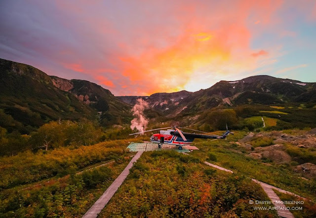
The Valley of Geysers is a geyser field on Kamchatka Peninsula, Russia, and has the second largest concentration of geysers in the world. This six kilometers  long basin with around 90 geysers and various hot springs is located on the Kamchatka Peninsula in the Russian Far East, mainly on the left bank of the ever-deepening “Geysernaya River”, into which geothermal waters flow from a fairly young stratovolcano, Kikhpinych. It is part of the “Kronotsky Nature Reserve”, which, in turn, is included into the World Heritage Site "Volcanoes of Kamchatka" and temperatures have been found to be 250 °C, 500 m below the caldera ground. The valley is one of the rare places in the world where geysers occur naturally, along with Yellowstone National Park in the United States and sites in Iceland, Chile, and New Zealand. The access to valley is extremely difficult; you can reach with helicopters available the only feasible means of transport.

In 1942 a local scientist “Tatyan Ustinova” has discovered the "pulsating" geysers of Kamchatka. Therefore, she revealed her findings after 14 years later and little exploration of the area until 1972. As the time goes, an idea was introduced to get systematic survey to be done in mid-1970 and later on, an automatic monitoring system was introduced in 1990. Out of hundreds geysers, only 30 geysers were given names. Hence one of massive geyser “Velikan” is capable of generating a jet of water reaching up to 130 feet. So, in the early 1980’s the area was promoted across the USSR, and popularity increase in the tourist magnets of Kamchatka and Russian Far East. However, foreigner visitors were permitted into valley in 1990. Almost more than 3000 tourists visited valley of Geysers annually.  The valley is an extremely paradise, steaming waterfalls cascade down the valley walls; grassy banks breathe with life; geysers erupts jets of boiling water; and bubbling mud pots gurgle and pop. Beautiful multicolored clays and algae- matted waterslides mark the landscape, and wafting aromas bear witness to sulfur-belching springs.

The Valley of Geysers has seriously suffered from the landslide on June 3, 2007, a gigantic mudflow inundated two thirds of the valley witnessed an exclusive natural event, but the consequences of such a natural catastrophe are irreversible. Therefore, the World Heritage Site has also expressed its deep concern over the issue. In fact this was a tragic event for humankind, in that we have lost one of the best rare natural wonders of the world. On June 5 2007, it was reported that a thermal lake is forming above the valley due to the landslide occurred while the documentary Wild Russia was filmed; it features footage of before and after the disaster. The extent of long-lasting change is not yet clear, but may be less than was originally thought. As of June 9, 2007, waters have receded to some extent, revealing some of the inundated features. Velikan (Giant) Geyser, one of the field's largest, was not buried in the slide and has in recent times been observed to be active. In 2008 the Valley of Geysers was elected as one of seven Wonders of Russia, because of several thousand people visit the Valley every year because of its remote location and reserve status. Nonetheless, the Valley is still very alive and attracts a lot of interest from scientists and tourists.

Saturday 29 August 2015

Incredible United States and European Tectonic Plates in Iceland pulling apart Leaving dramatic 200ft water-filled Crevices those Divers can explore

Visitors look like toys in these aerial photographs which reveal an impressive split landscape where two lands meet. The “dramatic terrain” the join between two tectonic plates is widespread with travelers who are curious to explore the natural wonder on land and underwater. Thus, the splits in the land, which has several faults, volcanoes, valleys, and hot springs, are caused by the Eurasian and North American plates in Iceland pulling apart.


 Therefore, some of the rifts are filled with majestic clear cold water where divers can every so often be seen exploring the underwater crevices, which can be up to 200ft deep. The crystal clean water is colored by the sand, silt and other minerals at the bottom and the deeper rifts can be visibly seen from above. If you want to take the colorful photographs “Jassen Todorov” a 40 years old photographer, flew in a Cessna 170 plane around 600m high. He’s professor in San Francisco State University, in California, USA, explains there were more than 300 people visiting Thingvellir National Park, in Iceland. The beautiful divide splits Iceland in two and it is very impressive to see from above. This is really a natural wonder to see once a life.  


Switzerland World Longest Tunnel 8,000 feet Beneath the Alps

Well, the incredible 35 mile long Neat Gotthard based tunnel construction has completed actually the world's longest and deepest railway tunnel, in Switzerland. The Tunnel has now surpassed Japan’s 14.5-mile Seikan Tunnel, which connects the main island of Honshu with the northern island of Hokkaido. The tunnel will transport passengers from Zurich to Milan in about two hours and fifty minutes, saving an hour off current travel time. The NEAT Gotthard Base Tunnel, opens to the public on June 1 2016, measuring 35 miles, it surpasses Japan’s 14.5-mile Seikan Tunnel. The mega projected was planned in 1996, and it took almost 20 years to complete. The ambitious project was funded by Switzerland at cost of around $10.3 billion or £6.5 billion.

More than 2,000 workers were drafted in to excavate over two million truckloads of earth from as deep as 8,000 below the surface of the earth. Due to the rugged terrain of the Alps, linking imperative cities, such as Milan and Zurich is no mean feat, but highly thanks to the tunnel being almost completely flat along its entire length, trains will soon be able to travel at over 150 miles per hour. Therefore, excavation involved huge tunnel boring machines cutting through almost 100 feet of rock every day. It was a dangerous process, and tragically eight workers died during construction.  The first safety tests will take place in October 2015. So far all scenarios will be considered and tested.  After opening the tunnel, it will be the safest stretch of the Swiss railway network. Moreover, in January 2016, thousand people will be selected to take the first voyage.


Thursday 27 August 2015

“Bunda Cliffs” Where the Earth End?


Bunda Cliffs is located on the Great Australian Bight in Southern Australia, is the vast, featureless Nullarbor Plain (is part of the area of flat, almost treeless, arid or semi-arid country of southern Australia), actually the “world’s largest single piece of limestone”, covering more than an area of 270,000 square kilometers and stretching over 1,000 kilometers from the east to the west. The area is so flat that the Trans Australian Railway runs across its surface for about 483 kilometers in a fully straight line. However, on the surface of the plain there are areas of slight depressions where sparse rainfall has slowly dissolved away some of the limestone. There are also places where underground caves or sinkholes have collapsed to form dents in the surface. But mostly, the plain is horizontally flat and devoid of trees, as its Latin name recommends. The “Nullarbor Plain” ends brusquely at the remarkable “Bunda Cliffs” containing over 200-kilometer-long precipice curving around the Great Australian Bight. Bunda Cliffs form the southern edge of the Nullarbor Plain which extends far inland. The white colored base you see near the bottom of the cliff face is Wilson Bluff Limestone. This chalky material made as part of an ancient seabed when Australia started to separate from Antarctica 65 million years ago. This Wilson Limestone is up to 300 metres thick but only the upper portion is visible in Bunda Cliffs. Moreover, above the white Wilson Limestone are whitish, grey or brown layers of limestone or crystalline rock. Few layers incorporate marine fossils as well as worms and molluscs indicating their marine origin. So, other layers are created with entirely of marine sediment (foraminifera). The Bunda cliffs are capped by a hardened layer of windblown sand laid down between 1.6 million and 100,000 year ago.

These majestically beautiful cliffs are some 60 to 120 meters high and sheer, and can be easily viewed from numerous viewing points along the Eyre Highway east of Eucla and west of Nullarbor roadhouse. However, they are better appreciated from the air. The Eyre Highway, Australia’s main east / west link, follows the line of this remarkable coast less than a kilometer inland. The highway was named after Edward John Eyre, who along with John Baxter and three aboriginals, set off from Fowlers Bay in 1841 in an attempt to reach Albany in Western Australia across the Nullarbor Plain. Though, lack of water and dangerous hardship gave rise to a mutiny and two of the aboriginal boys shot John Baxter and absconded. Eyre and the third Aborigine, Wylie, continued on their journey and completed the crossing in June 1841. The Eyre Highway was laid precisely a century later in 1941. Therefore, more than a distance of 85 kilometers along the highway, there’re 5 main lookouts on the cliffs with signed, gravel access roads from the highway. The western lookout is the most admired because tourists can walk to piece of rock jutting out of the cliff that provides a vantage looking point. At the eastern end of Bunda Cliffs there is a lookout at the Head of the Bight where tourists can stay for hours watching Southern Right Whales in the ocean below the cliffs. Whereas on the Southern Right Whales migrate from the sub-Antarctic in the autumn and give birth to calves in inshore water along the southern Australian coast, and then remain in the vicinity for months while the calves put on weight. Head of the Bight is one of these calving-mating grounds. If you want to see them, then there is a charge but then there is good viewing without environmental damage small price to pay.