Monday 22 June 2015

DeSoto Falls, Alabama


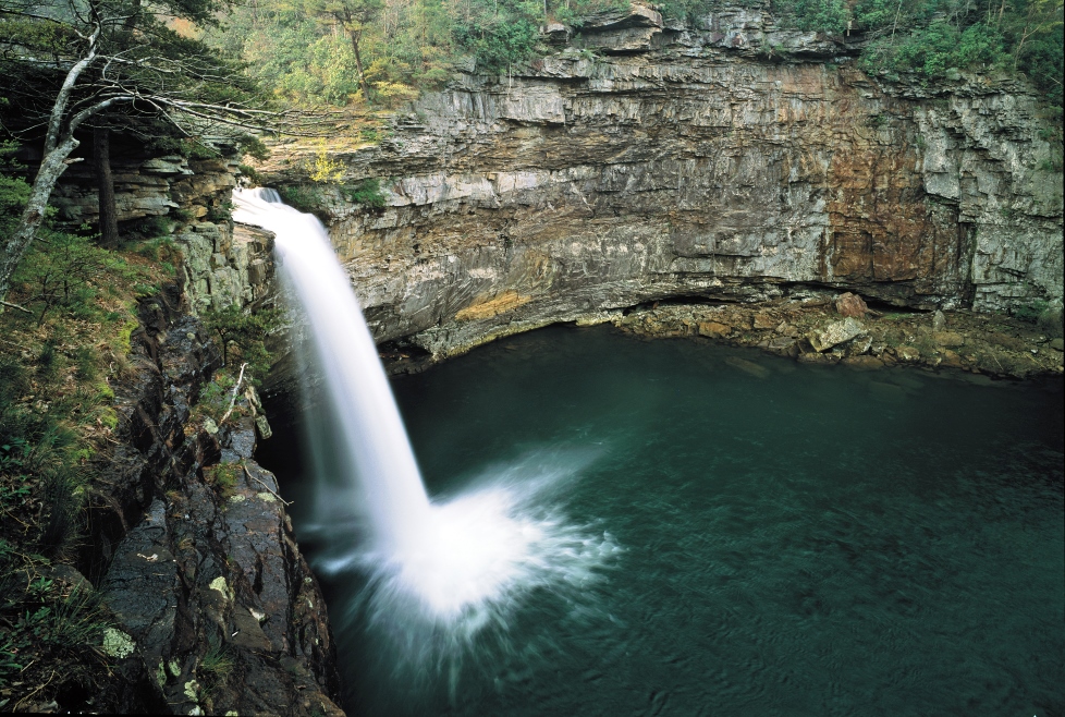
DeSoto Falls is a magnificent 104 foot waterfall located on the West Fork of Little River on the outskirts of the charming town of Mentone, Alabama. The falls have carved their own small canyon. They are named after Spanish explorer Hernando de Soto. The waterfall formed where the West Fork of the Little River plunges off a Lookout Mountain cliff, the waterfall is one of the most beautiful in the South. DeSoto Falls is one of the tallest and most visited waterfalls in Alabama, actually a part of DeSoto State Park.

DeSoto Falls has been a landmark for thousands of years. Native Americans frequented the falls long before the arrival of the first European explorers who, if old legends are to be believed, may have come here long before Columbus first set foot in America. Local legend holds that numerous small caves in the steep bluff below the waterfall were part of a fort built by Welsh explorers led by Prince Madoc. Because the believers in the story hold that Madoc landed on Mobile Bay in 1170 A.D. before making his way inland as far as the mountains of Alabama Georgia and Tennessee. Moreover the waterfall was a distinctive place to the Cherokee Indians who once inhabited this part of Alabama. The famed Cherokee scholar Sequoyah lived at nearby Wills Town in 1818-1823. It was there that he devised the Cherokee Alphabet.

The waterfall is now one of the major features of DeSoto State Park and one of attractive recreation era was established through the exorbitant hard work of the CCC (Civilian Conservation Corps) during the Great Depression. The key area of the park is a few miles south of DeSoto Falls and provides cabins and chalets, a motel, restaurant, store, picnic areas, hiking trails, campgrounds and more. Therefore, the water that flows over the falls forms one of the primary tributaries of the Little River. The stream is exclusive in that it is one of the few rivers in the nation that flow almost completely on the top of a mountain.


DeSoto Falls, AL from Raymond Clayton Thomas on Vimeo.

Lake Wanaka, New Zealand - 4K Hyperlapse

In April 2015 I (Matthew Vandeputte )got flown in by the Lake Wanaka tourism board to partake in New Zealand's biggest ever instameet. My role was to capture and show the beauty of the lake and it's surroundings. I shot 44028 RAW photos and ended up with 1,57 terabytes of data. After a few weeks of editing 97 sequences I ended up with this edit. It's been a while since I've spent this amount of time on an edit and I really hope you like it. If you do, please leave a comment or a thumbs up :)
You can follow my adventures, as well as my post processing techniques and workflows on Instagram, Twitter, Snapchat and Facebook. Come say hi!

instagram.com/matjoez
instagram.com/matjoez_bts
twitter.com/matjoez
Snapchat: Matjoez
facebook.com/tjoezthemoviemaker
lakewanaka.co.nz
Music via beatsuite.com
Motion Control gear by Kessler Crane USA
kesslercrane.com
Tripods by Manfrotto
manfrotto.com
Bags by LowePro
lowepro.com

Lake Wanaka, New Zealand - 4K Hyperlapse - Tjoez.com from Matthew Vandeputte on Vimeo.

Moscow 2014 Timelapse/Hyperlapse

From Kirill Neiezhmakov says at winter cloudy day city reminds old movie, but at nightfall Moscow transformed! This night TimeLapse in Motion filmed at winter in Moscow (Russia) during 5 nights.
Wow, This is really well done! and thought the editing and pacing of this piece was spot on. The amount of time that had to go into those hyper-lapses shows in their quality. Great job and showed quite a bit of passion here!

Shooting, post-processing and editing by Kirill Neiezhmakov
e-mail: nk87@mail.ru
vk.com/nk_design
music: Glitch Mob - Warrior Concerto
YouTube 1080p: youtu.be/leqyze7Py0o
Behind the Scenes are here youtu.be/wIZEqyPpqIE
Footage (this and many other) available for licensing in 4K
Equipment:
Canon 60d
Sigma 10-20 mm 4.0-5.6
Samyang 8 mm 3.5
Zenitar-M 50 mm 1.7
Canon 70-200 4L
Vanguard Alta Pro tripod


Moscow 2014 Timelapse/Hyperlapse from Kirill Neiezhmakov on Vimeo.

Sunday 21 June 2015

The World’s Largest Flower Garden in the Middle of a Desert.


Well, the world's largest flower garden in the last place you would expect, a spectacular rainbow-colored oasis with more than 45 million flowers is in the middle of a desert exploding with colors and textures. The Dubai Miracle Garden consists of more than 45 flowers species imported from all over the world. A multitude of shaped archways, flowerbeds and structures can be seen at the 18 acre site, is watered by a system that recycles waste water while avoiding evaporation. But then again, in the city that prides itself on pushing the boundaries of what can be achieved - from the world's tallest building to indoor ski slopes in the desert what can you expect? The remarkable bonanza provides a colorful oasis for the eyes of city workers, who can escape to the natural splendor which is nestled close to Arabian Ranches, in Dubai land. Currently there’re 45 species of flowers in the garden, which are imported in from all around the world, especially from Egypt to the United States.

The Dubai Miracle Gardens were opened in 2013, and were designed to attract tourist all over the world. In order to produce a fresh experience for visitors visiting the rainbow gardens, the displays are changed seasonally. These’ve included millions of flowers in the shape of a UAE floral flag, floral clock, a Ferrari car with driver decorated by flowers, a vertical buried car zone, flower apple structures, artificial animals, flower boats and an Islamic Arch Design. It is obvious that attractions would not be complete without open parking, VIP parking, sitting areas, prayer room, toilet blocks, security room, ablution facility, first aid room, and carts for handicapped visitors, retails and commercial kiosk and all other related services available to facilitate visitors.

If the natural landscape was not sufficient, what makes this attraction mostly impressive is the unique sub-surface irrigation system that recycles waste water via drip irrigation while avoiding evaporation and saving up to 75 % of water and energy. Moreover; there’s an awe-inspiring assortment of flowers most of which are rare and seen for first time in the Middle East, such as petunias and geraniums.


Britain's Breathtaking Beauty Spots


These mesmerizing photographs of Britain’s beauty spots should be plentiful to convince any holidaymaker to scrap their plans to jet abroad this summer and remain closer to home. The spectacular photographs of wild and urban landscapes serve as inspiration for the eventual staycation with photographers capturing magnificent images that collectively serve as a visual love letter to the UK’s amazing scenery. These beautiful photographs show everything from panoramas of London’s modern skyscrapers to climbers on Pinnacle Ridge on Isle of Skye in the north of Scotland. One amazing snap shows a misty morning on Ullswater in Cumbria, with snow-topped mountains reflecting off the water and the trees turning a shade of orange. The pictures include amazing snaps of rocky coastlines and lush woodland, and the volatility of Britain’s weather. 


Friday 19 June 2015

Silver Falls State Park in Oregon, United States


Silver Falls State Park is a state park in the Oregon, United States , actually located near Silverton, around 32 kilometers east-southeast of Salem. It is the largest state park in Oregon with an area of more than 9,000 acres, and it includes more than 39 kilometers of walking trails, of around 23 kilometers of horse trails, and 6.4 km bike path. The waterfall 14 km Canyon Trail/Trail of Ten Falls runs along the banks of Silver Creek and by ten waterfalls, from which the park received its name. Four of the ten falls have an amphitheater-like surrounding that lets the trail to pass behind the flow of the falls. The Silver Falls State Park Concession Building Area and the Silver Creek Youth Camp-Silver Falls State Park are separately listed on the United States National Register of Historic Places. The park's most visited waterfall is South Falls, a 177-foot cascade. Remote Double Falls, however, is listed as the highest waterfall in the park, plunging 178 feet in a small tributary side canyon deep within the Silver Creek Canyon. Silver Falls City formed in 1888 and was primarily a logging community with a few homesteaders, and the area was extensively logged. The small lumber town of Silver Falls City sat atop the South Falls, and as the land was cleared, a local entrepreneur sold admission to the Falls area, with attractions such as pushing cars over the falls and even hosting a stunt with a daredevil riding over in a canoe. By 1900 a Silverton photographer, June D. Drake, began to campaign for park status, using his photographs of the falls to gain support. (Drake Falls was later named for him. In 1926, however, an inspector for the National Park Service disallowed the area for park status because of a proliferation of unattractive stumps after years of logging.

In 1935 President Franklin D. Roosevelt announced that the Silver Falls area would be turned into a Recreational Demonstration Area. Private land that had been logged was purchased, and workers in the Civilian Conservation Corps were employed to develop park facilities, including the historic South Falls Lodge, completed in the late 1930s. It was used as a restaurant from 1946 until the late 1950s and was listed on the National Register of Historic Places as the Silver Falls State Park Concession Building Area in 1983. The Silver Creek Youth Camp Silver Falls State Park was also added to the National Register at this time. In January 2008, supplemental legislative session, Fred Girod of the Oregon House of Representatives sought federal designation of the area as a national park via a house joint memorial to the United States Congress, but the bill died in committee. The history of the canyon's formation originates about 26 million years ago to the Oligocene period, when most of Oregon was covered by ocean. After the waters of the ocean retreated around 15 million years ago, the flood basalt flows of the Columbia River Basalt Group covered the sandstone that had been the ocean floor. The softer layers of sandstone beneath the basalt sheet eroded over time, creating pathways behind some of the waterfalls that Civilian Conservation Corps workers widened to make safe for public use. Another geologic feature are many tree "chimneys" or casts, formed when hot lava engulfed living trees and disintegrated them. Moreover within the park are many waterfalls, including ten along the Trail of Ten Falls (marked * in the table below) and five more below the confluence of the North and South forks of Silver Creek. Volunteers inspired by the beauty and history of Silver Falls have been active there since establishment of the park in 1933.

Therefore, in 1986 the peoples and the park staff envisioned a mission and established the Friends of Silver Falls State Park, Inc. The main mission is "to further the educational and interpretive opportunities available to park tourists; to promote the preservation, protection and enhancement of the historical, natural, and entertaining resources within the park; and to assist in the implementing park improvements and educational programs compatible with the nature of Silver Falls State Park. As a result, this private and public partnership has created a more meaningful park experience for the nearly one million annual visitors to the park, far beyond what state park funding alone can provide. Since 1992, volunteers of the Friends of Silver Falls State Park have operated the Nature Store in historic South Falls Lodge. This store offers a variety of books, clothing and souvenirs in keeping with the park's nature theme. 

The organization has also been accountable for much of the interpretive signage along the Trail of Ten Falls. Other goals of the Friends include compiling oral histories from those who have memories of the park region, keeping alive the history of Silver Falls City, recognizing the work of the Civilian Conservation Corps and the Works Progress Administration in the 1930s and 1940s, maintaining the park's historic district, and continuing to place interpretive signs throughout the park's more than 9,000 acres.