Thursday 21 May 2015

The Angel Oak Tree, More Than 450 Years Old Tree in South Carolina


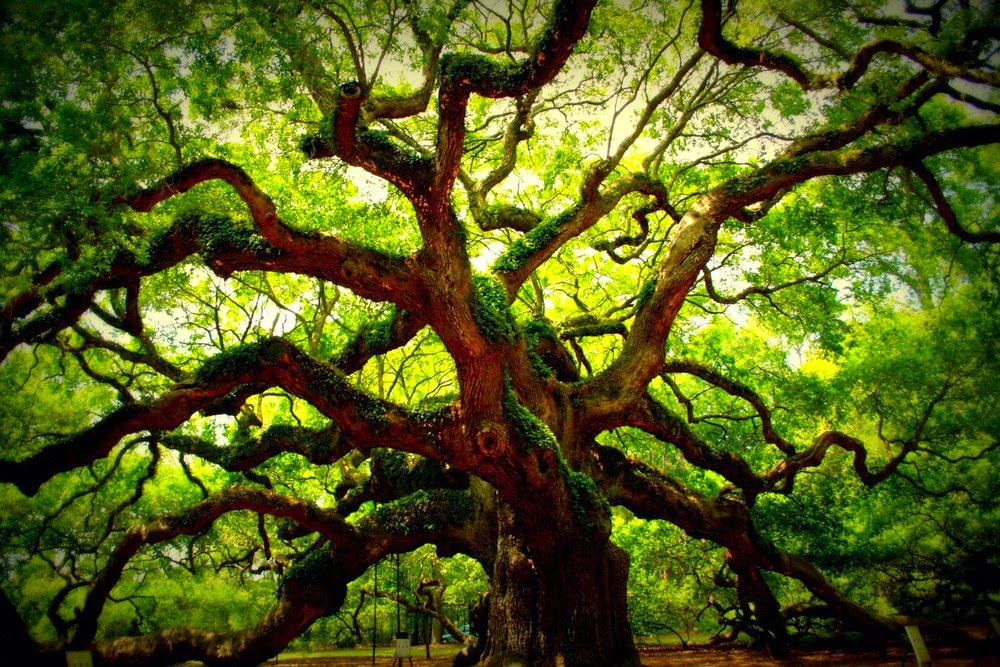
The Angel Oak Tree is a Southern live oak located in Angel Oak Park on Johns Island near Charleston, South Carolina. The exact date is missing, but it is believe the Angel Oak Tree is estimated more than 450 years old. It stands 66.5 feet tall, measures 28 feet in circumference, and produces massive shade that covers more than 17,200 square feet. The Angel Oak tree is the longest branch distance is 187 feet in length. Angel Oak was the 210th tree to be registered with the Live Oak Society. As you can imagine that natural disasters can damage to any tree in the world, and same was happened with Angel Oak tree, which were badly damage during Hurricane Hugo in 1989, but tree has tremendously recovered. So, therefore the City of Charleston has owned the tree and surrounding park since 1991. Angel Oak is a live oak and it is native to the low country and is not very tall but has a wide spread canopy.

The Angel Oak tree stands on land that was part of Abraham Weight’s 1717 land grant. The oak originates its name from the estate of Justis and Martha Angel, and local inhabitants tell traditional stories of ghosts of former slaves appearing as angels around the tree. Well, in spite of popular belief that the tree is the oldest one in the east of Mississippi River, but else, there are several bald cypress trees throughout the South which are many hundreds of years older. As the times passes, and modernization development taking place all over the world, and in 2012, development is started to encroach on the site of the Angel Oak, to build a 500 unit apartment complex, but Angel Oak was seriously challenged in court by a group called save the oldest tree and the coastal conversation league, their major concerns included the construction effect on available groundwater and nutrients. For visitors who haven't visited Angel Oak, you should know that it is this state's most impressive work of nature, more inspiring even than a plate of shrimp and grits. In the spring and summer season, there are various events take place, i.e.,  "Evening Under the Angel Oak" , dramatic presentations, and numerous other activities, particularly during the Spoleto Festival in May and June. 

Wednesday 20 May 2015

World’s Longest and Highest Glass-Bottomed Bridge


China has all set to open the most frightening walkway in the world, stretching a quarter-of-a-mile across a canyon at a dizzying height of 980ft and it's made of “GLASS”. Well it is highly recommended to stay away if you’re terrified of heights.  China latest attraction The Zhangjiajie Grand Canyon skywalk will hover over a nail-biting 980ft drop and is set to smash records to be the world longest and highest glass-bottomed bridge. The terrifying footbridge, which spans between two cliffs in the national park of Zhangjiajie, will be open to valiant tourists in July. Moreover, the frightening platform is no quick stroll, stretching a whopping 1,410ft above the inspiring Hunan province scenery. Therefore, those who fright the bridge will give way need not worry, as the 19ft-wide bridge is able to hold 800 visitors at a time. The further plans to arrange a fashion shows along the sky-high pathway, which has peerless views of the national park that was the stimulation for the planet Pandora in the movie Avatar. The ambitious venture will easily dwarf United State Grand Canyon Skywalk which sits 718 feet above the ground measuring 68 feet long. Israeli architect Haim Dotan was behind this mega project and those tourists who catch the adrenaline bug from completing the transparent walkway, there’ll also be the opportunity to try the world's highest bungee jump.

This record-breaking bungee will snatch the title from Macau Tower's 764ft-high attraction. A similar scary walkway opened in south-west China in Chongqing last month, which was extended 87.5ft from the edge of a cliff. Tourists are suspended in the air with 2,350ft of valley below their feet, leaving them feel as though they are walking on air.  Source: Dailymail

Palisade Head Cliffs on Lake Superior


Well, Palisade Head is a large rock formation on the North Shore of Lake Superior in the Minnesota. Palisade Head is located at milepost 57 on scenic Minnesota State Highway 61 in Beaver Bay Township, Lake County, about 86 kilometers northeast of Duluth and 5 kilometers east of Silver Bay. Palisade Head rising above an intermediate point, which is covered by a mixed forest of white spruce, mountain ash, aspen, paper birch, and oak. Palisade Head is under developed site, where there’re no improvements except for an access road, antenna tower, short-term parking, and some low rock walls near the edge of the cliffs. At Palisade Head, you can watch thousands of different species migration along the shoreline in the fall season.

Moreover raptors can frequently be seen soaring over the cliffs, the nest of Peregrine falcons, Bald eagles nest in the area, and thousands of hawks. There are beautiful trees are sparse, but plenteous wild blueberries and, less frequently gooseberries. When the sun is full shinning, there are majestic views of the Sawtooth Mountains, Split Rock Lighthouse, the Bayfield Peninsula, Apostle Islands of Wisconsin, and the ship traffic on Lake Superior. It is a regional center for rock climbing with many routes up the lakeshore cliffs, were used for more sinister, albeit fictional purposes in The Good Son, and partly filmed on location at Palisade Head.

Palisade Head is formed from a rhyolitic lava flow which was extruded approximately 1.1 billion years ago.  The flow some 200 feet thick formed tremendously hard volcanic rock which resisted a billion years of erosion which cut down surrounding formations. This was formed both Palisade Head and Shovel Point. The feature is a shallow headland, with Lake Superior to the southwest, and northeast. Its high point is more than 300 feet above the lake level; and lakeside cliffs stand up to 60 meters above water level. Source: Wikipedia


Tuesday 19 May 2015

“Kit-Mikayi” Mysterious Rock Formation in the Town of Kisumu in Western Kenya


Kit-Mikayi is a rock formation a tor almost 40 m high. Kit-Mikayi means “The Stone of First Woman” & “Stone of First Wife.” It is also called “Kit Mikayi”, “Kitmikayi”, and “Kitmikaye” is situated about 29 km west of the town of Kisumu in western Kenya. It is about one kilometer from the Kisumu-Bondo road, however, the sign board is on the gate of Kit Mikayi primary school and entrance is via N’gop-Ngeso primary school. The legend behind Kit Mikayi, which in Luo dialect means "the stone of the first wife", is that: Long time ago, there was an old man by the name Ngeso who was in great love with the stone. Every day when he woke up in the morning, he could walk into the cave inside the stone and stay there the whole day, and this could force his wife to bring him breakfast and lunch every day. The old man became passionately in love with this stone to the extent that when people asked his wife his whereabouts, she would answer that he has gone to his first wife hence the stone of the first wife. Moreover, local inhabitants living around the stones are recognized as the Luo-Kakello clan.

This place is associated with sacrifices and various legends from pre-Christian times, particularly stories explaining the meaning of the name. Kit-Mikayi is a regional point of sightseeing interest, exclusively among the neighboring Luo tribes. It also has become a famous local pilgrimage place for followers of the Legio Maria sect who come to the rock for several weeks at a time. Futhermore, the unique stone structure represents the Luo cultural polygamous family which had the first wife’s house (Mikayi) built further in between on the right hand side was the 2nd wife’s Nyachira house though the third wife’s Reru house was built on the left hand side of the homestead.

This rock also is seen to have a nuclear family whereby the father “Ngeso” being the middle stone followed by the bulky Mikayi “first wife”, and then second wife “Nyachira” and then followed by third wife “Reru” and further in front they’ve the child which is representing “Simba” the house for the first born boy in the homestead. From a long time, this stone has been a holy place for the villagers to worship in times of trouble. Kit-Mikayi is really a cluster of rocks is a mystery, because there are some stones, which are mysteriously hanging in the air by mysterious reasons, still influence the life of residents. Apart from stunning shape and patterns of the rocks, tourists are really surprised at the eerie environment at the footsteps of the cave and huge trees that grows horizontally leaves the impression of unnatural features. Kit-Mikayi rocks are so huge and heavey, as no human being could have arranged them in a spectacular style in which they’re appearing. Therefore, there are numerous spectacular rock formations which abound with myths and mythologies. In the past, only men were allowed near the rocks, but tourists are these days very welcome.


 Source: Wikipedia