Monday 11 May 2015

The Buried Fortress Town of Gonur Tepe in Turkmenistan


During the first half of the 2nd millennium BC, a civilization was established in the ancient delta of the Murghab River, on the southeastern edge of a territory famous then as Turkestan. This Bronze Age site is recognized as Gonur Tepe, a civilization that flourished before being buried by time, and discovered later on in present day Turkmenistan. In the seventh millennium BC, Murgab River became the place where first agricultural settlements started to appear. The site was called “Margush” in Old Iranian texts and “Margiana” in Greek. The Margiana region has an area of 3000 square kilometers, housing 70 oasis and 150 settlements. Gonur Tepe (or Gonur Depe) became the capital, serving as the administrative and religious center, and also a trade hub of the Margiana region. Nothing much was recognized about the complex of Gonur Tepe until 1972 when the Margiana Archaeological Expedition directed by the Greek-Russian archaeologist Victor Sarianidi 
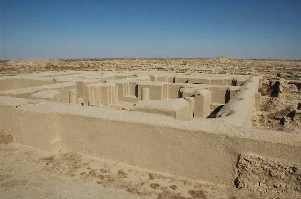
discovered the fortress town. In this expedition, it was revealed that “Gonur Tepe” was a rectangular fortress with defensive walls, semicircular bastions, and adobe buildings. 

A palace and temples with fire altars dedicated to the Zoroastrian religion were also discovered. Archeologist Sarianidi explained that Gonur Tepe is the 5th oldest civilization on Earth and was the birthplace of Zoroastrianism.Other discoveries included the extensive irrigation systems similar to the ones found in Egypt, models of two-wheeled carts, and silver and gold artifacts. 

The artifacts discovered on-site suggest that the town of Gonur Tepe had craftsmen who could mold metal and create materials for cult worship. Besides metal, the craftsmen also did bone and stone carvings.Sarianidi also found out what appears to be the boiler for the soma, a ritual drink known to give immortality mentioned in the Rigveda and also known as haoma in the Avesta. Dishes with traces of cannabis, poppy, and ephedrine were also found, which led to the theory that these were the ingredients of the immortality drink soma. 

Therefore; in 2009, a royal tomb was excavated in which remains of dogs, a cart with bronze-rimmed wheels, and a large bronze cauldron were discovered. Although getting to Gonur Tepe is not an easy task. You will have to need to hire a 4WD that will take you through a road that follows the Kara Kum Channel from Mary, Turkmenistan. The trip to “Gonur Tepe”  is a three hour drive from Mary.


Saturday 9 May 2015

Drifting Through Iceland

Took my drone for a flight in Iceland, shot with Gopro Hero 4 Black and a Dji Phantom 2 drone.
Locations:
Reykjanes Peninsula
Glacier Lagoon / Jökulsárlón
Blue Lagoon
Seljalandsfoss
Straumsvík
Vatnsleysuströnd
Gullfoss
Geysir
Please visit my website for more videos and photos: gardarolafs.com

Drifting Through Iceland from Garðar Ólafsson on Vimeo.

PHILIPPINES STA TRAVEL (5D RAW)

I was lucky enough to be one of 4 young Filmmakers to Promote 4 different areas of the Philippines sent out by STA Travel.
The 4 Films were based on: Volcanoes & National Parks, Beaches, Island Hopping and Social Tourism.
I went out with my Friend Jack - vimeo.com/jacksgap
Check out the other Filmmakers here:
- vimeo.com/benjamindowie
- vimeo.com/molliemills
- vimeo.com/maggie
Music: Hearts - I Break Horses
ibreakhorses.se/
Instagram: instagram.com/joshzoo/

PHILIPPINES STA TRAVEL (5D RAW) from Joshua Cowan on Vimeo.

Arbor Skateboards :: A Team Excursion To New Zealand

The Arbor Skateboards family rolled deep to New Zealand for the Mt. Ruapehu Gravity Festival. Liam Morgan, James Kelly, Tyler Howell, Brandon Tissen, KJ Nakanelua, and Kaimana Pinto spent their time outside of the event finding new roads and pushing each other to the limit.  With the legendary Levi Hawken for a tour guide, the boys explore Wellington and the North Island of New Zealand, unearthing some amazing scenery and roads. Keep your eyes peeled for some near death experiences and some adrenaline pumping wipeouts as Jack Boston captures some of the best downhill skating on camera yet. It might be the wrong side of the road down there, but it sure feels right.


Arbor Skateboards :: A Team Excursion To New Zealand from Arbor Collective on Vimeo.

Winter in Lofoten


The sun rises and covers the landscape in a soft pink light, as the rugged cliffs cast a lengthy shadow. Winter has the island under control. The attractive snowy mountains tower above the frozen fjords. The streets are empty and just a few travelers are en route. The turquoise water is shining in the sun. The day is marked by impulsive weather changes. Quick rages the snow and the sea are stirred up by the storm. The fishing boats cross the rough sea to catch some codfish, although the already gutted fish hanging to dry on the stock fish racks and wrap the island into a fishy smell. In the evening the island comes to rest, while the fishing boats return to the port. The small towns, with the well-known red Rorbuers are brightly lit and tranquility settles in. The sun sets and the sky turn into a dark blue. As night falls in Lofoten, the sky comes to life and you will experience an exceptional spectacle of nature that is hard to put into words. The Northern Lights flicker across the sky and cover the landscape in a green light. For hours they dance in the sky before the sun finds its way over the horizon. A new winter day starts in Lofoten.  In March 2015, I use to spend a week in Lofoten. I knew the islands already from a preceding visit in the summer; however, I wanted to go on Aurora hunting this time. The weather and solar activity play a conclusive role, so that a dependable forecast isn’t possible. The whole thing was more than uncertain and the unpredictable weather changes were the biggest challenge but I was lucky during my visit. In adding to the wonderful scenery, I was able to experience one of the most impressive natural phenomena.

Thanks Lofoten for unforgettable memories, I'll be back!
Equipment Used
Nikon D7100
Nikon D610
Nikkor 14-24 mm 1:2,8
Sigma 18-35mm 1:1,8
Nikkor 16–85 mm 1:3,5–5,6G
Walimex Pro 14mm 1:2,8
Nikkor 50mm 1:2,8
DIY Slider
Emotimo TB-3 Black
Lee filters
The footage can be licensed up to 4K resolution: tm@maiocchi.de
Please visits me on Facebook: facebook.com/tmaiocchi.photo
Website: maiocchi.de
Music by premiumbeat.com

Winter in Lofoten from Tommaso Maiocchi on Vimeo.

Friday 8 May 2015

Chan Chan: The World Largest Adobe City


Chan Chan city is located near the Pacific coast in the Peruvian region of La Libertad, approximately five kilometers west of Trujillo. It was the largest Pre-Columbian city in South America and the largest earthen architecture city in the world. Chan Chan was the capital of the Chimú civilization that stretched along the northern coast for a thousand kilometers from just south of Ecuador down to central Peru. The city itself was built about 850 CE and lasted until its conquest by the Inca Empire in 1470. At the height of the Chimú Empire, Chan Chan stretched more than 20 square km with a monumental zone of about 6 square kilometers in the center, and housed a projected 60,000 populations. Therefore, the city had 9 large rectangular citadels surrounded by thick earthen walls about 30 to 60 feet high. Moreover within these units, were thousands of buildings including temples, houses, stores are arranged around open spaces, together with reservoirs, and funeral platforms. 

The walls of the buildings were every so often decorated with raised carvings representing abstract motifs and animals. Outside these nine rectangular units were four industrial sectors fixed to woodwork, weaving, and the work of gold and silver. Unluckily, the city was deprived of these valuable metals by Spanish treasure hunters who ransacked the city during the 16th century. Moreover, an area further to the south was used for farming; the land watered by an intricate system of irrigation. Chan Chan was recognized in one of the world's bleakest coastal deserts, where the average annual rainfall was less than a tenth of an inch. It was due to dry desert air that allowed the city’s earthen structure to remains to this day. Ironically, due to the changes in weather conditions, nowadays Chan Chan is endangered by too much water, as heavy rains steadily wash away this ancient city.


Source: Amusing Planet

The Baffling Lakes of Badain Jaran Desert


The Badain Jaran Desert mainly occupies parts of China and Inner Mongolia covering an area of 49,000 sq. kilometers. The desert is 3rd largest desert in China, even though a lot of people are not familiar with this desert, outside China. It is well recognized for having the tallest stationary dunes on earth. However, some of these dunes have been measured to reach heights of above 500 meters. Moreover, Badain Jaran has an exceptionally arid climate with an annual precipitation between 50 to 60mm, as nearly 40 to 80 times of the precipitation gets evaporated away before it falls as rainfall.
Despite these arid conditions; one of the most amazing features of Badain Jaran is the existence of approximately 140 everlasting lakes that lie between the dunes. It’s these lakes that give the desert its name which in Mongolian means "mysterious lakes". These mysterious lakes are thought to be fed by underground water springs that flow under the gravel deposits and appear between the dunes where the deposits become fine-grained and the water flow is blocked. The main source of this water is precipitation and snowmelt in the mountains nearby the desert hundreds of kilometers away. There’re numerous oases in the basins because the snow and ice cover on the surrounding mountains provides lots of water. Moreover, Runoff from these mountains flows through the fractured rocks and gravel deposits beneath the desert, and then emerges at scattered places giving rise to several lakes. Though the springs carry fresh water, and most of the lakes are saline, which can be easily explained by their high rate of evaporation.
Therefore, some of the lakes changes color due to the presence of a large populations of algae, brine shrimp and minerals. Hence, evaporation has also led some hypersaline lakes to form salt crust around the rim of the lakes. Thus, the fresh water lakes offer the life sustenance in the desert supporting animals, i.e, camels, goats and horses which are herded by nomads that travel through the desert. Many lakes also provide support a green ring of vegetation that populates the close vicinity around the lakes. In the recent decades, a number of these lakes have shrunk or even disappeared, as a consequence of reduction in groundwater brought about by urbanization, irrigation, water diversion, and an increase in population. Sub saline and fresh water lets the development of fixed dunes. Which are replaced by semi-fixed and migrating dunes as the distance to the lake increases? In numerous saline lakes, small travertine islands, with fresh spring water, are found. The areas of the inter-dune lakes or basins are controlled by the scale of the mega dunes. The base area of the mega dunes and those of the inter-dune basins are linearly related. Whatsoever the cause of this collection of lakes, tourists can be sure to be uncertain about whether what they witness makes sense. After all, it's not often that sand and saltwater intermingle.