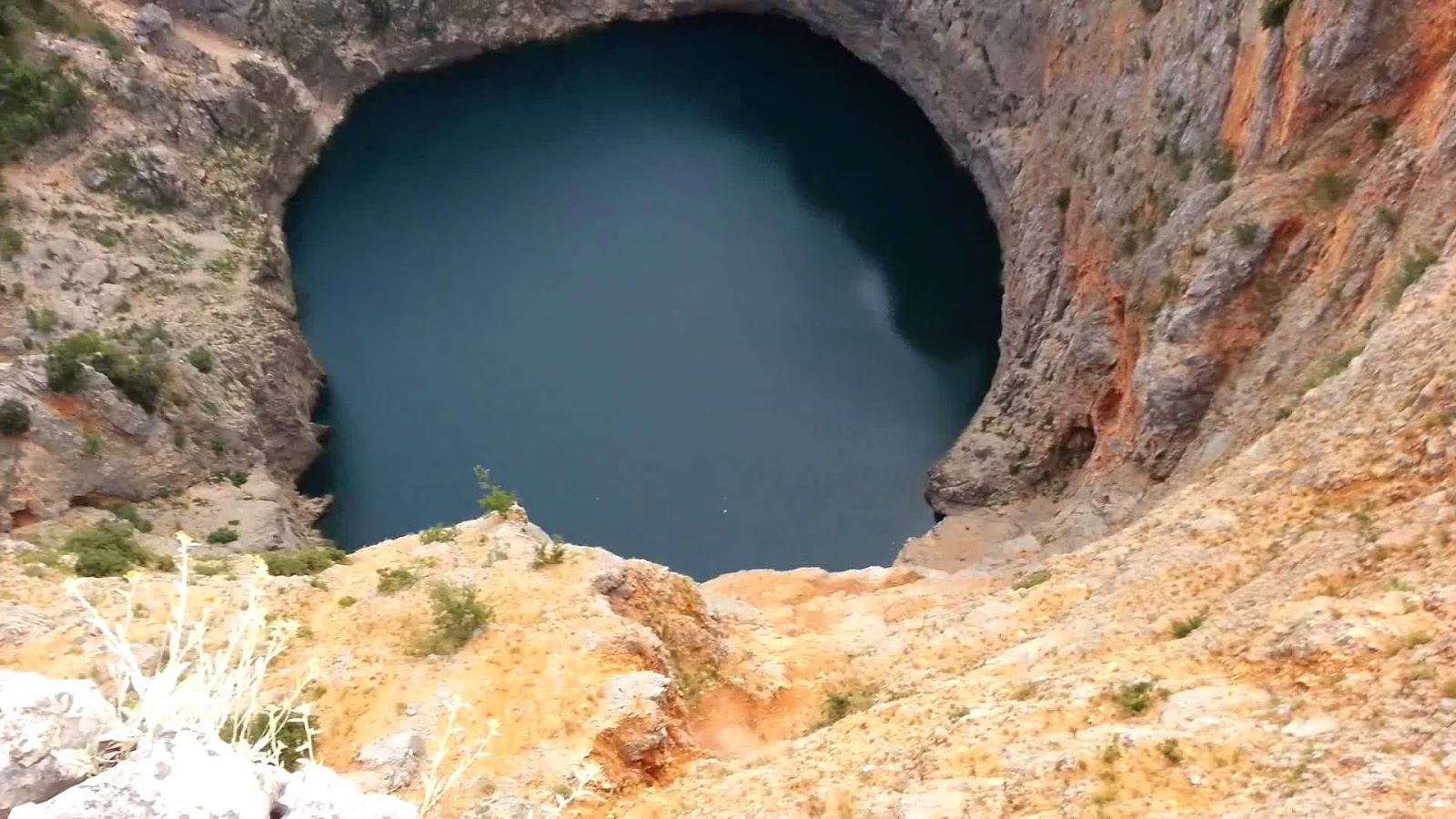
Friday 20 February 2015

Wander in Turkey


“WANDER IN TURKEY" is one of travel series video of Hang Gab Lee, who has directed this magnificent travel video. This is really like having no plans when i'm in unfamiliar place. I just wander which makes me face unplanned situations and people. Sometimes I can melt into their daily life and have a deep relationship. I was fascinated by Turkish culture and natural scenery. Also, I could feel that there is a various cultural sensibility from Asia and Europe. I mostly captured videos in Istanbul and Cappadocia. Hope you enjoy my video.


Blue Lake of Imotski Croatia


Blue Lake or Modro Jezero or Plavo Jezero, is actually a karst lake situated near Imotski in Southern Croatia. Like the neighboring Red Lake, it lies in a deep sinkhole probably formed by the collapse of a massive underground cave. The lake total depth from the upper rim is around 220 meters, though water depth varies with season. In spring season, when the snow from surrounding mountains melts, it can reach 90 m, and in 1914 it reached 114 m, overflowing the southern rim.

The lake is a widespread destination for hiking and sight-seeing. Moreover the maximum dimensions of the lake are around 800×500 m, but they considerably vary due to big changes in the water level, and at the end of the summer the lake may completely disappear. In 1907 a road was built descending to the lake, and in 1942, an earthquake caused a large landfall resulting in reduction of the lake's depth. The lake of this sinkhole is easy to access and thus it is popular swimming place. In fact Blue Lake is a big chasm near Imotski, the peoples who likes to take walks to the main vista and back to the town. It is very reachable and several man made vistas in the lake offering gorgeous views. It is highly recommended that you should spend few hours exploring. Lovers tend to spend longer than that amount of time.

It is the one of the most frequent reasons for parents scolding their kids who cannot stop exploring it. There’re stone built trails that go almost to the bottom of the lake. They’re very busy during the summer when the young and not so young people go swimming there. The trails were built in year 1907, during the reign of Frantz Joseph. However; they were renovated several times. The last time they were fortified with concrete. They’re in very good shape now, ready to take an onslaught of Towner’s and out of town visitors, mainly the Imotski natives who left Imotski pursuing their carriers. Moreover near the bottom of the lake there’re three plazas that are quite popular with the visitors. You could hear a popular refrain "Dela, dela skolane moj" around one of the large flat stones where the kids play games.

Wednesday 18 February 2015

Coyote Gulch, Escalante, Utah, USA


Coyote Gulch is located in a remote section of the Glen Canyon National Recreation Area; it is one of the most valued hiking destinations in southern Utah. The magnificent natural beauty draws backpackers in and makes it worthy of its renowned status. The gorgeous Navajo Sandstone canyon walls, the glittery streams, two arches, a natural bridge, Fremont Indian pictographs and quite a few waterfalls will make this hike a favorite spot. However it is relatively easy to understand why this rousing canyon is by far the most admired hiking destination of all the canyons of the Escalante. But because of this, plan on encountering a number of other hikers in Coyote Gulch during the spring and fall months.

Though some experience the canyon as a day-hike, most travelers select to spend two to four nights backpacking in Coyote Gulch to take in the maximum experience the canyon is offering. Though to reach the trailheads for Coyote Gulch drive on State Highway 12 until you reach the Hole-in-the-Rock Road (officially the Glen Canyon Recreation Area Road) and the “40 Mile Bench turnoff sign where the road makes a big U curve. This is around 5 miles southeast of Escalante, Utah and 41 miles east of the Bryce Canyon turnoff. At the bottom of the U, exit the highway to the south on a large, maintained dirt road. Escalante is the nearest city with your last available services. But make sure that these dirt roads may be washed out or have stretches of soft sand, so a four-wheel drive vehicle is highly suggested. 

This is one of the most popular canyons with full of adventures, exploration, wonder, worth and sufficient time required for special efforts to visit this worthy & famed spot. While exploring Coyote Gulch, you will see the landscape much the same way that the Anasazi culture and early Western explorers, soldiers, and settlers did. Characterized by sparkling streams, impossible arches, and daunting vertical walls of Navajo Sandstone, you will be raving about this canyon for years after your trek. Well, you’ve to be physically fit to plunge yourself into the heart of geologic time as you contemplate the eons that have preceded your insignificant life span. How will you navigate these emotional floods of humility and adventure as you gaze over the matchless beauty before you?

Tuesday 17 February 2015

Ice Cave Network beneath Iceland’s Giant Vatnajokull Glacier

The magnificent ice cave of Iceland’s Vatnajokull glacier appear in a kaleidoscope of colors as the light and conditions change in these incredible photographs by local guide Einar Runar Sigurosson. More than two hundred British tourists annually brave the network of caves in Europe's largest glacier mass found in the south of Iceland where Einar runs tours for profound photographers throughout the winter, the only time visitors can go inside. The ice takes on the form of massive teeth or gigantic waves trapped in suspended animation in the maze of interconnected frozen chambers and they can be a glowing blue as they enhance the sky's reflection or close fluorescent oranges and reds when a fire is lit inside. He has taken these photographs on the south side of Vatnajokull glacier, which is beautifully, covers over 8,100 square kilometers or over 8% of Iceland and is estimated to have a volume of 3300 cubic km. Every year, in autumn, we’re start looking for the ice cave visit, and we find caves in several different locations on the south side of Vatnajokull.

Sometimes they are very different, sometimes not as exceptional but become distinctive in the right light and conditions. Sigurosson runs the ice cave tours with his wife “Matt” and son “Aron” through their company Local Guide of Vatnajokull, formerly known as From Coast to Mountains. Some caves are very stable and we can go in there in any weather, but others are less safe and we might not even go there at all, even if they are very beautiful. However some caves are only accessible in below zero conditions for example if there is water in the floor that needs to be frozen over to walk into the cave.

Monday 16 February 2015

Ponte Vasco da Gama Bridge! One of Longest Bridge in Europe

The Vasco da Gama Bridge is a cable stayed bridge flanked by viaducts and range views that spans the Tagus River in Parque das Nacoes in Lisbon, capital of Portugal.  The magnificent bridge is 17km long though 10km of which pass over water, making it the longest bridge in Europe when it was opened in 1998 and still today one of the longest in the world.

Vasco da Gama has the same length as the road-rail tunnel-bridge linking Denmark and Sweden. The bridge vastness enforced engineers to factor in the curvature of the earth during its construction. That makes it a wonderful feat of engineering, made up of numerous sections supported by pillars, built at a cost of one billion US dollars.  Ponte Vasco da Gama bridge was well inaugurated on March 31, 1998 after 18 months of day/night work construction, and just in time to carry visitors from southern Portugal, Spain, and other parts of Europe to Expo98.

The Vasco da Gama is surely not as charismatic as the Lisbon’s other bridge the golden arched Ponte 25 de Abril but its sheer size and ability just to stretch out into the horizon is an engineering marvel. Lisbon has always been plagued with heavy traffic issues and during the mid-90’s traveling south out of Lisbon had become insupportable with the six lanes Ponte 25 de Abril simply unable to handle the volumes of commuters. Suggestions for a new bridge had been bounced around for decades but the distance to traverse, poor foundations and possibility of seismic activity had always pushed the construction costs beyond that of which the government could have the funds for.

The opening of the bridge coincided with the opening of Expo 98 as floods of Spanish and European tourists traveled to Lisbon from the east of the city. The value presently set for enlargement is when the average number of cars exceeds 52,000 per day and it is expected with the next 6 years. The bridge has a life expectancy more than 120 years, having been designed to withstand wind speeds of 250 km/h and hold up to an earthquake 4.5 times stronger than the historical 1755 Lisbon earthquake estimated at 8.7 on the Richter scale.