A private
owner invested £3 million and transform Spitbank Military Fort into a
high-class luxury island retreat. Spitbank is located approximately a mile away
from the coast of Portsmouth in Hampshire, United Kingdom. The gorgeous Spitbank
Fort Hotel provides nine guest rooms that are nothing short of expensive along
with three beautiful restaurants that come with bars, library, hot on rooftop,
sun decks and a sauna. The unique idea consist of several original features
from the fort have been retained such as the exposed brick walls, original
fortress windows and a few cannons as well. Those who’re visiting the Fort
hotel are met at Gosport and then taken to the hotel through a private boat.
Therefore the second approach is to fly to No Man's Land Fort - big brother to
the Spitbank and then take a boat ride lasting 10 minutes to reach the
extravagance hotel. The Spitbank Fort provides twilight dinner and delicious
Sunday lunch and both of which are experiences that you will never forget. The
fort can be hired in private as well for sailing weekends, parties and
weddings. But you must keep in mind that the stay at the hotel is extremely
high with per head cost being £350.
A compendium of interesting places, hidden wonders, Beautiful Places, strange travel destination, tourist attractions.
Saturday 18 October 2014
Wednesday 15 October 2014
Mount Babel Alberta, Canada
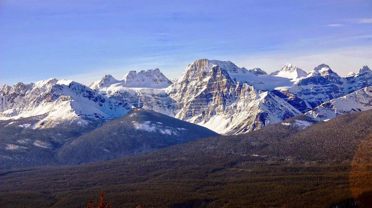
Mount Babel is a 10,173 feet (3,101m)
mountain peak in the Ten Peaks in Alberta, Canada. As per Peakery data, it
ranks as the 140th highest mountain in Alberta and the 258th highest mountain
in Canada. The adjacent peaks are Mount Fay, Mount Little, Mount Bowlen, Tower
of Babel, Quadra Mountain, and Bident Mountain. Mt. Babel is one of the most
popular mountains in the Valley of Ten Peaks that beautifully surrounds Moraine
Lake in Banff National Park. The smaller and less known Consolation Lakes lie
just behind Mt Babel.
The stunning lakes can only be
reached by climbing across the rockslides that have tumbled down from towering
Mt Babel. These images shows the gorgeous beauty of autumn colors of the golden
yellow larches on the rocky slopes of Mt Babel and some of them are very big
rocks that lie just at the edge of the first Consolation Lake. The dramatic Mount
Babel rises vertically some 1000 metres above the Consolation Valley, and the
mountain was the scene of one of the most dramatic rescues in the history of
the National Park Warden Service. The rout to Mount Babel is really an
impressive rock route, because it cannot be called a classic (having only been
climbed twice) but it definitely offers a thrilling day's climbing. It could be
an astonishing effort for the time when it was first climbed. The majority of
the route is now free, with a limited points of aid that keep the grade
reasonably sensible.
Therefore the approach trail
(Consolation Lake Trail) to the Tower of Babel is a commonly used trail among
the tourists who are delivered in mass by bus to the Lake Moraine Lodge. The
one of pictures shown below is actually stitched together from 15 separate
images as it is not possible to get this enormous mountain at such close range
into a single shot even with a very wide angle lens. The image is taken by standing
on a small island in the wide outlet channel from the lake. The gorgeous Mt.
Babel can be reached depends upon your fitness level, as you’ve to walked from
one rock to another to cross to the island. For the time being, if you look
closely you may see tiny companion sniffy stuck on top of a sharp and steep
sided boulder middle foreground just at the water's edge. Mount Babel was first
climbed by A Hart, Edward Oliver Wheeler, L. Wilson and H. Worsfold in 1910.
Ten other mountain peaks nearby
to Mount Babel
1. Mount Fay (3234 m) 1.1 km
2. Mount Little (3134 m) 1.8 km
3. Mount Bowlen (3206 m) 1.8
km
4. Tower of Babel (2221 m) 2.1
km
5. Quadra Mountain (3174 m) 2.2
km
6. Mount Perren (3051 m) 3.2
km
7. Mount Allen (Canada) (3310 m) 4.3 km
8. Mount Tuzo (3248 m)
4.5 km
9. Chimney Peak (3002 m) 4.8
km
10. Mt Deltaform (3424 m) 5.4 km
Sunday 12 October 2014
The Rock Formations of “Flatirons” Colorado
At Boulder, Colorado, there’re
rock formations called “Flatirons” consisting five large numbered Flatirons
ranging from North to South as well as east slope of Green Mountain. The Flatirons were recognized as the
"Chautauqua Slabs" circa 1900 and "The Crags" circa 1906. “The
Flatirons often refers to these five alone. Moreover various additional named
Flatirons are on the southern part of Green Mountain, Bear Peak, and amongst
the surrounding foothills. It would be really hard to locate another location
in the country where such a widespread variety, from scrambling to hard
"Head Point" routes exist so close to a major metro area. Geologists
believe the age of these rocks formation as 290 to 296 million years; they were
lifted and tilted into their present orientation between 35 and 80 million
years ago, during the Laramide Orogeny.
There are two hypotheses
regarding the origin of the current name, one based on resemblance to
old-fashioned irons, the other based on resemblance to the Flatiron Building
completed in 1902. The Flatirons comprise of conglomeratic sandstone of the
Fountain Formation, which were subsequently exposed by erosion. Further
manifestations of the Fountain Formation can be located in several places along
the Colorado Front Range, including Garden of the Gods near Colorado Springs,
Roxborough State Park in Douglas County, and Red Rocks Amphitheatre close to Morrison.
If it is your first time climbing
in the Flatirons then you must try to take a guidebook and a map, or better
yet, go with a local. Also, a headlamp can come in handy as well on the journey
home, but that's a story for another day! There’re a few things that needs some
attention, such as there is plenty of poison ivy in places for the sensitive.
Also, there’re mountain lions & black bear that are well-known to wander
these parts. Watch your kids, if you're climbing with little ones. The
Flatirons on Green Mountain are popular destination among hikers and rock
climbers with rock grades ranging from easy (5.0) till world class (5.14b). The Flatirons on Green Mountain are ubiquitous
symbols of the Boulder and abounds with photographs, drawings, paintings and
sculptures. This symbol is normally used in advertisements and marketing
materials and often referred to Tech industry as the “Silicon Flatirons”.
Saturday 11 October 2014
The Lava Tree State Park Hawaii United States
The Lava Trees in Lava Tree State Park were created in a 1790
lava flow, which entered the area and buried the 'Ōhi'a Trees up to 11 feet
deep in molten lava. The Lava Tree State Park sits within the Nanawale Forest
Reserve in the lower Puna district near the town of Pāhoa. Although lava trees
can be found in several locations on the Big Island this particular park have a
number of exceptional examples as well as being very accessible.
When the hot lava from a volcanic eruption enters in a
forest, often it is observed that the lava does not overthrow the bigger trees,
but flows around them. Normally the moisture in the tree make cools the lava in
contact with the trunk and a hard exterior shell is molded. So as the lava
drains away, only the solidified “lava trees” are left standing. The intense
heat burns away the wood inside and a hollow cast in the shape of the original
tree is left behind. In particular cases, the tree can keep on standing and
stays for years as a black charred skeleton, and in sporadic cases, specific
trees even survive and continue to grow after the eruption. The finest example
of lava trees are originate on the island of Hawaii, in southeast of Pāhoa in
the Puna District.
Here, the whole forest of ohi’a trees was swamped in molten
lava up to 11 feet deep, when the Kilauea volcano erupted in 1790. The higher trees
that were surrounded by the molten lava cooled the lava that coated them, though
the heat of the lava began the tree to burn to ash. Therefore since then a close
fissure opened in the ground letting the molten lava to drain away back into
the earth. Nonetheless the lava surrounding the trees had already cooled and in
progress to harden and remained above ground as monuments to the trees that
once stood in the same spot. The forest of lava trees causing from eruption of
a one kilometer line of vents east of Pu‘u Kahaualea. The bulbous top of each
lava tree marks the high stand of the lava flow as it spread through the trees.
As the fissure eruption diminished, the flow constant to spread laterally; its shallow
subsided, leaving pillars of lava that had chilled against tree trunks.
Then spattering is from fissure out of view to the left. Note
blob of spatter following to the top of the stripped ‘ohi‘a tree. Nowadays, the
Lava Tree State Park contains of 17.1 acres of native plants, trees and several
lava trees. Several of the lava trees are well covered in moss, though others
have fallen to the ground, revealing their interior hollow structure. Specific
of the casts are so impeccable that you can still realize the imprint of the
bark in the lava rock itself.
The Lava Tree State Park is in the lower Puna district, and
to get to the park you need to take Highway 130 towards the town of Pāhoa, then
pass the first intersection that takes you into Pāhoa and at the next
intersection make a left onto Pāhoa-Kapoho Road. Follow this road for just
three miles until you see the park on your left. The park has a paved parking
lot and restrooms nearby from the parking lot. Moreover there is no drinking
water available in the park. The trail around the park is paved but is jagged
and broken in places due to tree roots. The trail is not navigable through its full
length by wheelchair. The Lava Tree State Park is at around 500 feet above sea
level. The climate conditions are wet though warm. Shorts and rubber slippers
or shoes are suitable. You might want to have light rain gear in the car in
cast it decides to rain. The park is open 24 hours a day, year round. There is
no cost to visit the park.
Subscribe to:
Posts (Atom)