Sunday 21 September 2014

Deadvlei Namibia


Deadvlei is a white clay pan located nearby the more famed salt pan of Sossusvlei, inside the Namib-Naukluft Park in Namibia. This is also written DeadVlei or Dead Vlei, which means "dead marsh". In English this is called dead and Afrikaans vlei, a lake or marsh in a valley between the dunes. The pan also is referred to as "Dooie Vlei" which is the completely Afrikaans name. When you’d be search on Google there’re numbers of references to the site, its name often being translated speciously in terms such as "dead valley"; a vlei is not a valley which in Afrikaans is "vallei". Nor is the site a valley; the pan is a desiccated vlei. Well; Dead Vlei has been claimed to be surrounded by the highest sand dunes in the world, the highest reaching 300-400 meters often called "Big Daddy" or "Crazy Dune"), which rest on a sandstone terrace. The clay pan was shaped after rainfall, when the Tsauchab river flooded, generating short-term shallow pools where the profusion of water allowed camel thorn trees to grow. 

Hence when the climate changed, drought hit the area, and sand dunes encroached on the pan, which blocked the river from the area. Then the trees died, as there no longer was sufficient water to survive. There’re few species of plants remaining, such as “Salsola” and clumps of “Nara”, adapted to surviving off the morning mist and very rare rainfall. The remaining skeletons of the trees, which are believed to be about 900 years old, are now black because the extreme sun has burned them. Nevertheless not petrified, the wood does not decompose because it is so dry.


Carezza lake or Karersee Lake Italy


The Karersee is located in South Tyrol Italy and is considered one of the most beautiful of the many Alpine lakes. The lake lies in the western Dolomites, about 25 kilometers from Bolzano at an altitude of 1,520 metres in the municipality of Nova Levante. It is not particularly large: approximately 300 m long and 130 m wide. Lake of Carezza in Val d'Ega valley is well known for its wonderful colors and also called "Lec de Ergobando" and can be called Carezza Lake is a pearl of the Dolomiti. Nestled between an ancient forest of grand firs and the Latemar mountain is place of legends and beauty a nymph lives under its emerald waters.

Lake Carezza is the most beautiful lake in the Alps, because its reflection of the Rosengarten creates massive twinkles on the surface like jewels sparkling in the sun. Legend has it that a magician smashed the rainbow he had created to seduce a mermaid into the lake, sending lovely colors tumbling into the water. The chirping birds loved listening to the water nymph, but as soon as they heard some strange noise, they would twitter nervously and fly around in fear. Thus, the nymph would have time to dive into the lake and disappear, and never came into danger. The lake is mainly fed by subterranean springs from the Latemar massif.

The lake depth and size changes from season to season and depends on the weather, and at its max depth is 22 m deep. The little mountain lake is renowned in particular for the smooth, deep green of its water and the lovely backdrop of the mountains with the Catinaccio and Latemar mountains in the background. The lake is associated with many South Tyrolean legends and numerous writers and painters have selected the lake as the motif for their paintings and tales. The lake can be reached on the State road 241 (Val d'Ega State road, also recognized as the Dolomites State road). The road to the Passo di Costalunga, which runs in close nearness to the lake, is particularly busy in summer and during the day causes a certain amount of trouble. T

he lake is fenced and it is prohibited to walk on its banks. The lake is at its most striking in the evening or early morning, when the streams of tourists have not yet monopolized the nearby car park and the Catinaccio and Latemar mountains are reflected with the green of the Carezza forest in the crystal-clear water. A beautiful water nymph once lived in the lake.  The Lake of Carezza is still filled with the brilliant colors of the rainbow and why the Ladin people call it the ‘Lec de ergobando’, the Rainbow Lake.

Saturday 20 September 2014

Half Dome Hike California United States


Well; the hiking is a great passion for human health. Hiking is an 
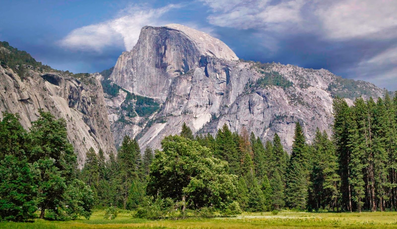
iconic symbol of Yosemite grandeur and “Half Dome” just begs to be climbed. The 7 miles route to this granite landmark through the Mist Trail sees 2,500 to 3,000 folks per day during summer weekends, making it the most heavily trafficked corridor in the park. Half Dome is the signature landmark of “Yosemite National Park”.  An average man can finish the approximately 16-mile, 12-hour hike to the top of Yosemite’s signature landmark if they have three things: Education, Preparation and Motivation.

The most famous or infamous part of the hike is the ascent up the cables. The two metal cables allow hikers to climb the last 400 feet to the summit without rock climbing equipment. Even though many folks are bear fatigue, altitude sickness, and dehydration in their willpower to stand atop Half Dome’s broad 8,836-foot-high crown. Steel cables bolted into the granite assist climbers up the final 400 vertical feet, but the combination of high, open rock and metal fixtures makes this a lousy place to get caught in an electrical storm. And once the raindrops start falling, the rock becomes dangerously slick. Yosemite’s search and rescue team responds to 300 incidents each year more than any other national park and not surprisingly, and claim six deaths since 1995. So you’ve have to be very fit and honestly survival plan assesses your fitness level.

If you want to hike the half dome you'll need a permit. The dome itself reflects the general shape of an intrusion of granodiorite deep underground. As the intrusion became exposed by erosion, the change in pressure caused the rock to crack apart in thin shells, which fall off the sides and leave the mountain clean. So this process is called exfoliation, and Half Dome is a classic exfoliation dome.  The Mist Trail is a hard hike; you’ve to leave early not later than 5 a.m. to give yourself the best shot at completing it. Hike on a weekday between late May and early October, a period when the cables have generally been installed. Assess the sky before you commit to the cables, and never climb them when the rock is wet: That’s when almost every fall from Half Dome has occurred. The keys points for success are: 1. Begin early, 2. Wear good boots, 3. Drink plenty of water, 4. Use hiking poles and 5. Use rubberized gloves for the cables. Moreover you must check sunrise and sunset times before you start your hike, and always bring a flashlight or headlamp with good quality batteries. Though the trail is well marked, you should be prepared with a good topographic map and compass, with the ability to use them. Indeed Half Dome hiking is an instant lifetime memory; so it is recommended you must do it once a life. It is challenging but rewarding folks. Prepare yourself so that you will be successful and able to summit the peak.

Half Dome Elevation:  8,842 feet (2,695 meters)
Total Elevation Gain:  4,800 feet (1,600 meters) from Yosemite Valley
Hike Distance:  14.2 miles (22.7 km) round trip via Mist Trail
16.5 miles (26.5 km) round trip via John Muir Trail
20 miles (32 km) round trip via Glacier Point
23 miles (37) km round trip via Tenaya Lake
7 miles (11 km) round trip from Little Yosemite Valley campground
Hiking Time:  10 - 14 hours