Saturday 17 May 2014

Wli Waterfall Ghana


Wli Falls are located about 15 kilometers south east from the city of Hohoe (inVolta Region). Wli is the highest waterfall in Ghana about 70 meters drop! And is a part of the Agumatsa River.  On the way to the falls there are 11-log bridges that have to be must cross. So first to admire is the sheer 
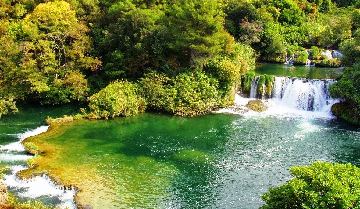
grandeur of the fall itself; the remarkable white water of the Agumatsa River thundering about 60 meters down steep cliffs into a large pool. And second are 
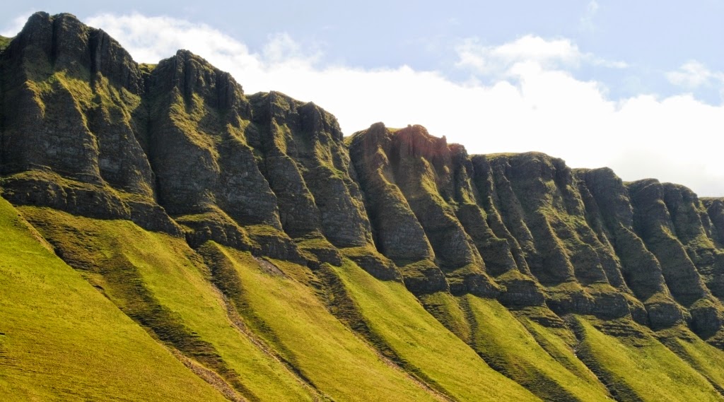
the huge mountain formations comprising of soaring peaks and rock walls which are part of the Akwapim-Togo Mountains
At the bottom of the falls there is a natural pool which is really great for swimming but extremely cold. Wli Falls is so lovely and heavenly beautiful and crystal clear water fell in a pool of sand. There’re creeks under the water and one should not go near them else they can be washed away. The place is fully safe and tourist can go there easily, the local’s peoples did not cause any problem to the tourists. Another attraction about Wli is the luxurious forest environment presently designated as the Agumatsa wildlife sanctuary. Approachability is another advantage of Wli falls, visitors don’t have to climb any hills or descend steep valleys to get to the foot of this splendid geological monument.
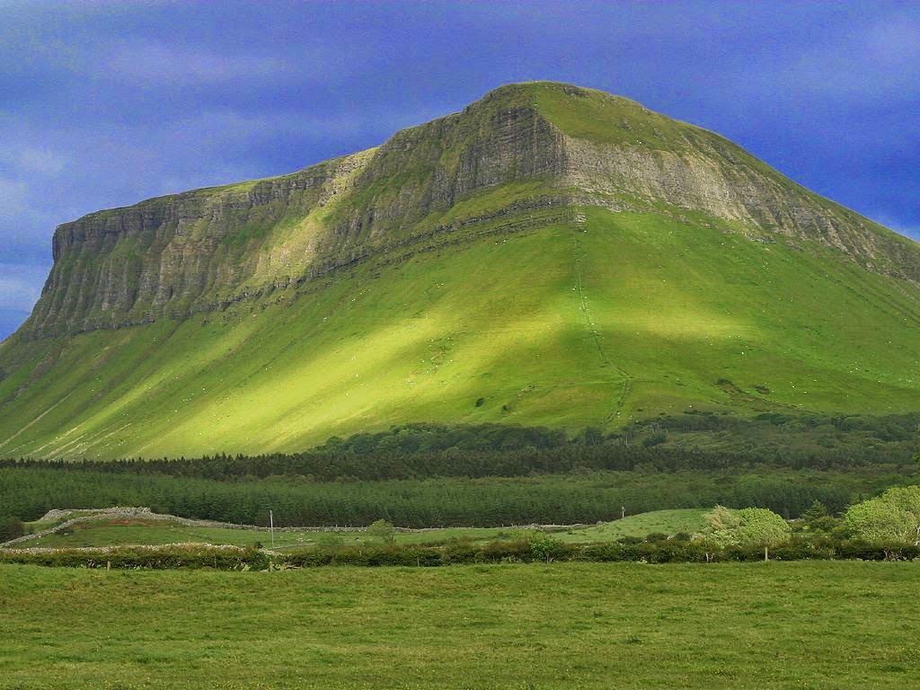
When you’ll sit on the terrace you have a great view of the gorgeous Wli Waterfall and the mountains with Ghana's highest summit, Mount Afadjato (880 m). Moreover; sun loungers invite you to relax in the midst of nature. Therefore; on the large covered terrace you can enjoy a cool drink and some tasty food. You can explore beautiful surroundings walking or biking.
Grown-ups and kids alike enjoy the Wli Waterfall within easy walking distance to the various species of wild flora and fauna. You can discover exotic butterflies and flying dogs, and even you can sit down on bamboo benches in the forest to take a rest. A dip in the pool or showering at the foot of the water fall offers a refreshing break particularly on hot days. If you want to go the upper cascades then you require appropriate shoes and some stamina. The hike takes about 4 hours. Moreover; early afternoon sunshine offers the best lighting conditions for taking beautiful pictures.
As the Ghana leading waterfall the continuing efforts to develop the site for Ecotourism will serve as an significant model for the many in the area such as the Tagbo and Flabo falls as well as those in other parts of the country though the distinctive terrain and setting of each fall would demand different approaches. There are accommodation facilities at Afegame for overnight visitors. Numerous categories of accommodation also abound in Hohoe town; about 25 minutes’ drive from Afegame. For stress relieving, cultural lessons, relief from mundane activities and socialization, it is highly recommended Wli waterfalls as your next holiday destination.


Ben Mount Benbulbin Ireland


Ben Mount Benbulbin is located in County Sligo, in the extreme north-west of Ireland, 10 KM north of the town of Sligo. The mountain Benbulbin is 527 meters and an entire county of Sligo and its symbols. Benbulbin is a protected site, designated as a County Geological Site by Sligo County Council. According to Irish legend, lived on this mountain monstrous boar of Benbulbin, Diarmuid was killed and buried in a hill Lech MUIKAM, near Dramkliffa at the foot of Benbulbin, according to his will, buried the great Irish poet WB Yeats. Its present form the mountain was during the last glacial period. Initially, it had a high “hump” that was cut creeping glacier.
Benbulbin almost entirely composed of limestone rocks. The name Benbulbin is also echoed in the name of the king Conall Gulban, a son of Niall of the Nine Hostages who was associated with the mountain; though, whether he was named after the mountain or the mountain after him is not clear. Benbulbin was shaped during the ice age, when Ireland was under glaciers, actually it was a large plateau and with the passage of time it converts into distinct formation. Benbulbin Mountain is composed of limestone on top of mudstones and these rocks formed approximately 320 million years ago in a shallow sea. Fossils exist throughout the layers of the mountains. All layers have many fossilized sea shells. The shale layer also holds some corals.
Benbulbin is an established dangerous climbing destination because the side bears the brunt of the high winds and storms that come in from the Atlantic Ocean. However if you climb from south side of mountain which is considered easy side since that side slopes very gently. And when climbers reached the summit, they’re rewarded with a magnificent view over the coastal plain of north Co. Sligo and the Atlantic Ocean. Therefore; Benbulbin hosts a unique and rare variety of plants, including particular organisms found nowhere else in Ireland. Several are Arctic–alpine plants, which grows in cooler temperatures than is normal. Some plants were deposited when the glaciers created Benbulbin i.e wild hares and foxes inhabit Benbulbin. In 2012, some researchers exposed that the Fringed Sandwort had survived the Ice Age and is possibly 100,000 years old. 


Monday 12 May 2014

Skradinski Buk Waterfall of Croatia


The most popular waterfall on the Krka River is “Skradinski buk” which is longest and one of Croatia’s best known natural wonders. The waterfall is a huge, clear, natural pool with high falls at one end and cascades at the other. The most famous lakes in Croatia is clearly Plitvice lakes, which are a must see site for every visitor in Croatia. If you travel by car to any region in Croatia, you will be able to visit at least some of best waterfalls in Croatia, and Skradinski buk is one of them. 

The Skradinski buk is the lowest of the three sets of waterfalls formed along the Krka River and located about 13 KM downstream from Roški slap and an entire of 49 KM downstream from the source. Skradinski buk is considered one of the most beautiful cliff water falls in Europe. You can see them with a walk through a Forrest on a wooden path and bridges. A beautiful walking trail has been constructed over the river that takes tourists on a light walk through the deep shade of lush Mediterranean and sub-Mediterranean vegetation.

The growth of travertine barriers at Skradinski buk was caused by the merger of the waters of Krka River with the 3KM lower current of the ÄŒikola River at RoÅ¡ki slap, producing one of the most rare and lovely landscapes of the Krka National Park. The combined waters of the Krka and ÄŒikola Rivers flow over the 17 steps at Skradinski buk, distributed along the 800 meters in length. The width of the cascades is between 200 and 400 metres with an overall height difference of around 45 meters. Travertine formations in the lower portion have caves and tufts while the upper portion of the river includes thresholds, travertine islands, draperies and barriers. 

A 60 minute light walk over bridge take you to deep shade of lush Mediterranean and sub-Mediterranean vegetation, which offers the unique microcosms of mystical sounds, lights, colors, the mysterious world of travertine mosses and plentiful plant species of the travertine barriers and aquatic habitats. Fortunate tourists will not miss the heart catching song of the nightingale, the splashing of the coot, the swimming of the Illyrian ide, the call of the green frog, the flight of the hawk and the playful ballet of emerald dragonflies and colorful butterflies.

Mar Chiquita, A Lovely Oval Shaped Beach in Puerto Rico


Can a beach be secluded and popular at the same time? Mar Chiquita has someway managed this feat, still retaining its sense of private allure as the surrounding town of Manatí developed. Mar Chiquita, also called “Little Sea”, is a small beach in a protected cove close to eastern end of a long rocky wall uncovered on the coast of Manatí in northern Puerto Rico, almost 40 KM west of San Juan. The north shore of Puerto Rico has miles of beautiful shoreline and it is one best spots for great views on the island. The Atlantic Ocean is always pounding against the rocky outcroppings along the shore carving it into interesting shapes. But that it is not to say you can’t find a calm beach on the north shore.

The lovely oval shaped beach lies behind the rocky wall in a trivial cove protected from the rough Atlantic. The wall was breached by the action of waves to form a 25 meter opening where the tide entered and formed a bay in the shape of the English alphabet U. The waves inside the cove are of substantial height as the result of the backwash meeting the incoming waves at their breaking point, building up the size of the waves. However; due to the shape of the cove and the narrow area between the rocks where water comes in and goes out, there can be serious undertows. It is possible to get sucked out into the open ocean when the water flows back out of the cove. Generally, it is calmer in the summer months so you can wade or snorkel, but it is not always good for swimming due to its strong undercurrents and rocks. 

Mar Chiquita was once a famous beach with a beautiful setting of palm trees, golden sand, and the imposing ridge of pitted eolianite. These days, Playa Mar Chiquita is still an elegant beach, but it is no longer as secluded as it once was due to the major urban development occurring on the coastal plains of Puerto Rico. Though, the beach’s fame has not declined, even on any given day of the week you can see some family picnics, and visitors playing beach sports, or simply enjoying the landscape and sunbathing. One popular activity is to climb and explore the eolianite ridge that forms the rocky headland of Punta Mar Chiquita, on the northeast side of the beach. 

It is likely to walk on all the rocks, but be aware, the limestone rocks were a bit slippery in some spots and they are really sharp. Shoes are essential flip flops are not sturdy enough. Unfortunately if you slipped and fell, it would hurt a lot! Another thing to watch out for is huge waves that have been famous to come over the top of the rocks. Stay alert. Although facilities are scant, with just a couple of huts serving light fare. Bring a beach chair this is a place to relax and soak it in.