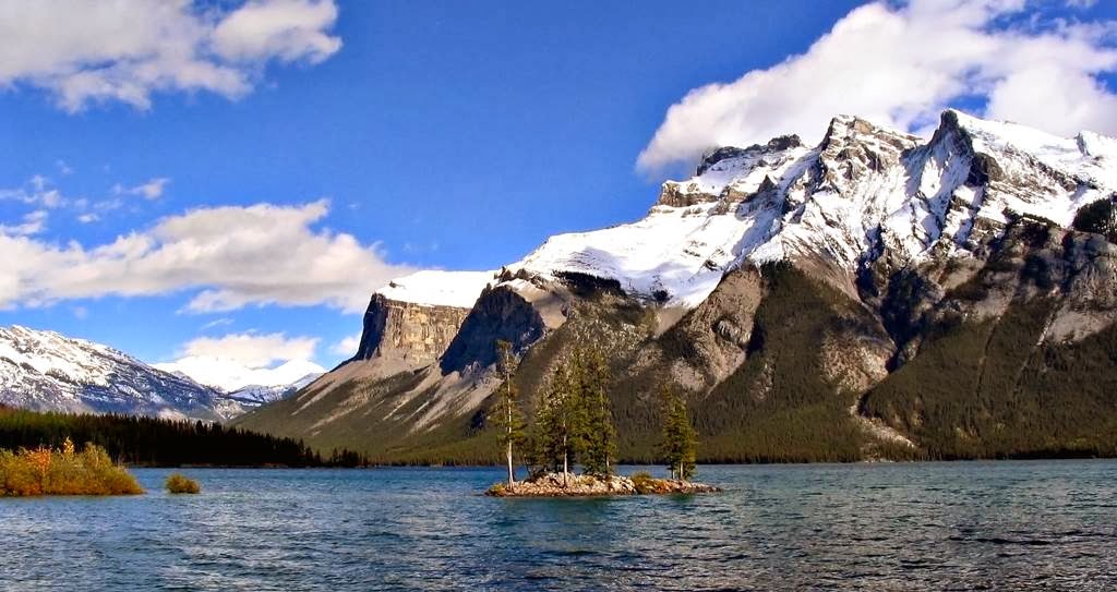
The most beautiful Lake
Minnewanka is actually a glacial lake located in the eastern area of Banff
National Park in Canada, at least 3.1 miles northeast of the Banff town site.
The lake is 28 kilometers long and 466 ft deep, making it the longest lake in
the mountain parks of the Canadian Rockies. There’s a power dam at the west end.
The lake is fed by the Cascade River, flowing east of Cascade Mountain, and
runs south through Stewart Canyon as it empties into the western end of the
lake. Numerous streams flowing down from Mount Inglismaldie, Mount Girouard and
Mount Peechee on the south side of the lake also feed the lake. Aboriginal
people long inhabited areas around Lake Minnewanka, as early as 10,000 years
ago, according to stone tools and a Clovis point spearhead discovered by
archaeologists. The area is rich in animal life i.e bears, elk, mule deer,
mountain sheep, and the easy availability of rock in the mountainous terrain
was most important for fashioning weapons for hunting. The western end point of
the lake can be reached by following Lake Minnewanka road from the Trans-Canada
Highway. Boat tours are easily accessible near the parking lot. A hiking and
mountain biking trail runs along the northern shore of the lake, passing
Stewart Canyon and six backcountry campsites. Dams were built in 1912 and 1941
to supply the town with hydro-electric power. Lake Minnewanka itself has a
popular with recreational SCUBA divers. Lake Minnewanka is actually the largest
lake in the park, and really a great place of picnic point.
A compendium of interesting places, hidden wonders, Beautiful Places, strange travel destination, tourist attractions.
Sunday 9 February 2014
Butterfly Valley Turkey
Butterfly valley is located about
15 kilometers south of Ölüdeniz and 30 km south of Fethiye. The Butterfly
Valley is protected by the World Heritage Foundation and gets its name from the
exclusive butterfly species. Faralya was well-known simply as the "village
on the cliffs of the Butterfly Valley" till in recent times, when travelers
begin to take a deeper look to the village, actually a quite pleasant sight to
see, with its houses and gardens cascading towards the cliffs of the Valley. There
are over 60 different species of butterfly in the valley several appearing in
the day time and others only venturing out at night. Butterfly Valley actually
discovered by hippies in 1990s when their beloved Blue Lagoon was lost to mass
tourism. There are numerous rare butterflies and for those who are enthusiasts
there is a small museum located in the valley dedicated to giving more in depth
information about the species that can be found there.
A narrow and winding road
connects the village to Ölüdeniz, although the distance is not to much where it
joins the main highway towards Fethiye near the Blue Lagoon. Though the
distance is not that huge, it takes about 30 minutes to drive this road because
of the conditions. During peak season June-August there are boats three times a
day from Ölüdeniz to the Butterfly Valley. Hiking is another activity from
Ovacik, and most hikers do the 16 Kilometers track in one day. But two days
track is much more convenient, especially in summer. The butterfly valley and
village are connected by a very steep and dangerous path. At many places there’s
a need of mountaineering skills. Normally it takes one hour to do the entire
path, depends upon your physical fitness, with two young backpackers having
died when attempting the route in the last decade. It is highly recommended to
never take shortcuts and always stick to the route marked with red dots because
taking a shortcut was the reason of death of one of the backpackers
The path starts from in front of
the guesthouse George House up in the village and marked with red dots all
along it. Local residents used to know
this area by the name Güdürümsü before the valley was re-christened with the
rather romantic current name. Faralya market
provides only grocery store of the village which offers a very meager selection
of vegetables, snacks, and drinks, although the prices are higher even paying
twice or three times more than elsewhere. In butterfly valley only two options are
available for night stay, the Bungalows or camping in a tent. But if you select
to stay in the village you’ve number of guest houses and hotels. If you choose
to stay up in the village itself, you have a number of guesthouses and hotels
to choose from.
Saturday 8 February 2014
Torngat Mountains National Park Canada
The breathtaking wilderness of Torngait
meaning “place of spirits,” and the Torngat Mountains have been home to Inuit
and their predecessors for thousands of years. The Canadian National Park
comprises 9,700 km2 of the Northern Labrador Mountains natural region. The park
was established on 22 January 2005, making it the first national park to be
created in Labrador. It is highly recommended that all visitors must register
before entering in the Torngat Mountains National Park. The park's headquarters
is located in the nearest town, Nain, which is 200 kilometer south.
The park outspreads from Saglek
Fjord in the south, including all islands and islets, to the very northern tip
of Labrador; and from the provincial boundary with Québec in the west, to the
iceberg-choked waters of the Labrador Sea in the east. The mountain peaks along
the border with Quebec are the highest in mainland Canada east of the Rockies,
and are dotted with remnant glaciers. Therefore; Polar bears hunt seals along
the coast, and both the Torngat Mountains and George River caribou herds cross
paths as they migrate to and from their calving grounds. Probably the best way
to see the park is through cruise ship. A lot of small expeditionary ships
annually visit the area, and they use zodiacs or other small craft to ferry you
ashore for hiking and sightseeing adventures. The highest mountains in Canada
east of the Rockies can be found within this beautiful land
Due to its remote location, the
park varies greatly from its more accessible cousins in the south. The trip needs
careful planning, registration with park officials, and the right equipment. Keep
in mind there are no roads, no campgrounds and no signs telling you where to go
or what to see. These days, Inuit remain to use this area for hunting, fishing,
and travelling throughout the year. Torngat Mountains National Park offers a
serious challenge for wildlife, in spite of these challenges; the park has a
variety of boreal and arctic species. The National Park protects wildlife caribou,
polar bears, peregrine falcon, and golden eagle among others, however; offering
wilderness-oriented recreational activities like hiking, scrambling, kayaking. When
you join the Inuit on these trips listen to the ancient stories and legends of
the area as you sip on hot tea and eat hot food that has been prepared over an
open fire. Everything you see and experience will leave an unforeseen and significant
impression.Source: Charismatic Planet
Friday 7 February 2014
Krkonoše National Park Czech Republic
Krkonose National Park is unique
mosaic ecosystems of Czech Republic consider most valuable natural area in
central Europe. Due to its uniqueness the area is declared National Park in
1963. Visitor come this wonderful place to explore high mountain slopes, flat
ridges, alpine meadows with colorful wildflowers and mysterious moorlands, all
presided over by the “Czech Matterhorn”. This would be an amazing and terrific
tour to an unspoiled landscaped with full of distant views, steep climbs, and
accurate marked hiking trails of all difficult levels. Therefore; you can found
a Museum here. The importance of the local landscape led to the Krkonose being
included on the UNESCO list of biosphere reserves. The Krkonose National Park
management headquarters are located in the town of Vrchlabí, often called the
Gateway to Krkonoše.
The majestic beauty of Krkonose
National Park is most valuable sites, probably along the marked trail of Obří
důl to Sněžka. This route is so demanding because of wonderful vistas of the
expansive alpine landscape definitely make the effort worthwhile. This will
offer the impressive view into the depths of the Obří důl Valley before
climbing the highest Czech mountain, from where you can see almost half of
Bohemia. The most interesting experience for you is the unique sights of the
Krkonoše Mountains? Then you must go to Studniční Mountain, on whose southern
slope you will find the so-called Map of the Republic.
The middle of this area is
consists of green meadows and dwarf pine forests lies a field of snow. As the
snow in the valley melts, its shape slowly changes into a map of the Czech
Republic. Moreover; sometimes it is happens in the Krkonose that a 5m snowbank
never completely melts, so you must take warm clothing when visiting this
place. It is considered one of the harshest climate conditions in Europe. Apart
from main tourist destinations, you must plan to Rychory natural unspoiled trail,
called Red Mountain and Devil’s Valley, due its natural beauty & fantastic
view. Even you can go the Elbe River through a famous hiking route leading to
the Labský důl Valley. Along the way you will see spectacular views of the
Pančavský Waterfall, the highest falls in the Czech Republic. Its waters
plummet into the valley from a height of up to 250 meters. It is an impressive
theatrical show which few would expect to see in Central Europe.
The beautiful nature and clean
air and active movement will feel as if they’re really in Paradise of Krkonose
Mountains. Here you can find unlimited climbs and crossings, and you just
select one starting point, such as Špindlerův Mlýn, which is possibly the most renowned
Czech winter resort and in summer serves as a great entry point for exploring
the Krkonoše National Park. Source: Charismatic Planet
Subscribe to:
Posts (Atom)