Thursday, 10 September 2020

Gouffre de Padirac, France

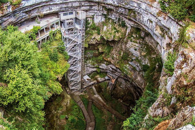
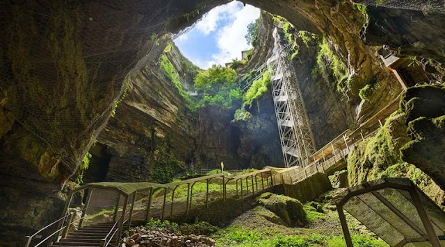
The Padirac Chasm is a cave situated near Gramat, in the Lot department, Occitanie region, France. In French Padirac chasm is called Gouffre de Padirac itself is 338 ft deep, with a diameter of about 33 108 ft. Tourists descend 75 m via a lift or a staircase before entering into the cave system. The Padirac Chasm comprises a subterranean river system that is partly negotiable by boat and is viewed as one of the most extraordinary natural phenomena of the Massif Central. This beautiful cave was created at an undetermined point in time when the roof collapsed into a large internal cavern.

It is known that the cavern existed in the 3rd century and was inhabited during the 15th and 16th centuries during which time Potassium nitrate was excavated from the area. In 1898, The first tourists visited the cave. In April 1899, Georges Leygues, the 87th the prime minister of France, officially opened the site for tourism. Today, although the cave system is made up of more than 40 km of galleries, only 2 km have been opened for tourism. Padirac Chasm was truly also one of the first tourist sites in France in the 19th century!

Since the 1930s, guests can access the cave system by descending 75 m by lift or stairs and then exploring the cave system on foot and by boat. Padirac Chasm is the most regularly visited underground tourism facility in France. Furthermore, 350,000 visitors annually, and a record of 460,000 in 1991. The cave was first explored, in 1889, by Édouard-Alfred Martel. Much of the credit for opening the cave system is owed to Guy de Lavaur, who came to Padirac in 1938 and managed to penetrate 15 km of the passages. Visitors can plunge into the depths of one of the largest chasms in Europe and take a boat ride on an underground river to explore the most extraordinary caves in the Dordogne Valley.

Also, the Natural cavern of 33 meters in diameter formed when the roof collapsed. Also, the 500 meters further, tourists continue the circuit on foot via a series of lovely rooms.  the Rain Lake and the pendant-like Pendeloque stalactite, the Salle des Grands Gours with a lake, and then the Salle du Grand Dôme with its impressive 94-meter-high ceiling. All these natural formations are breathtaking. Imposing and impressive in size and loveliness, the Great Dome Room is a real mineral cathedral. This enormous sinkhole has carved out remarkable caverns in the limestone, full of massive stalactites and stalagmites deep under the ground then punt along a subterranean river of pristine turquoise water. 


Product You May Interested


Wednesday, 26 August 2020

Sufed Mahal Marghraz Swat Valley

The White Palace ofMarghazar (Sufed Mahal) was built in 1940 by the first king of Swat, Miangul Abdul Wadud in the small town of Marghazar. The Sufed Mahal is located more than 7,000 feet above sea level on Marghazar Hill, about fourteen kilometers away from the small city of Saidu Sharif. Marghazar was declared as the summer capital of the Swat valley state.

Presently, Sufed Mahal is serving as a hotel. Miangul Jehanzaib who was the wali of Swat often spends their summertime at the White Palace of Marghazar Swat valley.  Therefore, with the passage of time, the palace was converted into a tourist resort.

Miangul Abdul Wadud the king of Swat likes the green spot, so the majestic greenish area attracts to him. So, historical sacredness, and above all, he decided to build a summer resort at Marghazar in 1935.

There are twenty four active capacious ornamented rooms and the Royal Suite (ex-King’s bedroom) where Queen of England Elizabeth II and Duke of Edinburgh Prince Philip stayed for three days in 1961.

The magnificent white marble adding the beauty to Royal White Palace and hence name was given to the palace. The Badshah Sahib (King) Miangul Abdul Wadud was a fan of imported marbles, so he decided to bring marble from Agra, bronze from Belgium.

Turkish artisans designed and constructed the palace, completing it in 1941. The first name was Swati Taj Mahal, later on, it was called Motti Mahal and now Sufed Mahal (White Palace). Therefore, different fauna and flora enriched the place and made it a mini zoo as well as a mini botanical garden.

The White Palace has two ample conference halls where King Abdul Wadood used to hold a cabinet meetings along with lobby to have a beautiful view of the garden lawn. Moreover, on the right side, there is a beautiful airy veranda to have a sight of a swirling stream of water.

Thus, on the left side of the building, a six-roomed Lord's Block for the residence of advisors and ministers. On the upper portion of the palace, there is the eight-roomed Prince Block; it is an enclave in trees and shrubs. If you go further upstairs, there is a 12 roomed Queen's block.

The raw material of White Palace was imported from Jaypure India, the same quarry that supplied marble to the Taj Mahal Agra. Moreover, lime (white Chuna) is used as a binding material in place of cement. It is so compact to be drilled. The height of the ceiling is 30 to 35 ft to give extra strength and ward off heat. Amazingly, ceiling fans were imported and installed in 1941 and are still working.

Badshah Sahab had two wives so he built this block in a way that each wife got 3 rooms, 3 servant rooms, and a separate lawn in her share. The counterpart portion of the second wife is a replica of the first one. In front of the lawn, there is a single balcony with marble benches and a table with engraved paintings of grapes.

Miangul Asfandyar Amir Zeb became the owner after the death of King Miangul Wadood. These days Miangul Shahriyar Amir Zeb is the owner of the White Palace. There is also a 200-year-old colossal chinar tree, serving as a canopy for visitors.

Visitors relish the pleasant weather in summer. They go in huge numbers to enjoy the cold water springs, peaches, apricots, ripe persimmons, and lush green high rise mountains peaks. However, in the winter season, the valley attracts visitors for its unending white snow sheet.

The White Palace is now converted into a hotel and has become a visitor attraction in summer. There are a number of beautiful shops offering multiple items to visitors. The onsite eating place offers an extensive selection of both traditional and non-traditional food. Whenever you go to Swat, it is a highly recommended place to visit.  Moreover, you will also enjoy zigzag roads turning into a lush green valley.


Product You May Interested

Friday, 7 August 2020

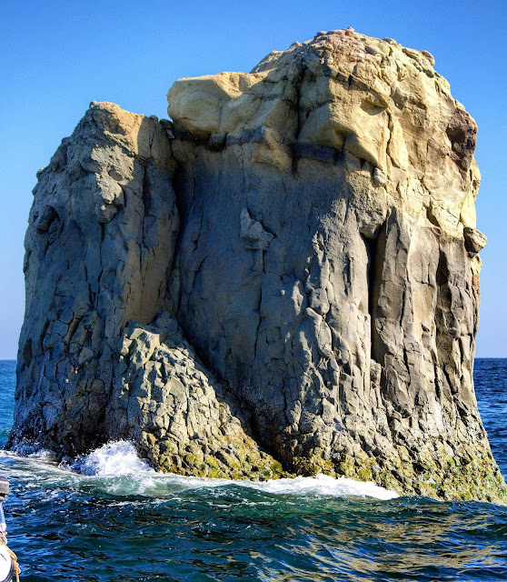
Shag Rocks – South Georgia

The Shag Rocks are six small islands in the westernmost extreme of South Georgia, 240 km west of the main island of South Georgia, and 1,000 km off the Falkland Islands. The Shag Rocks cover a total area of fewer than 49 acres. Situated on the South Georgia Ridge, they have a peak elevation above sea level 246 ft and stand in water approximately 1,047 ft deep. 

The average temperatures fall between −1.2 °C to 10 °C and rarely climbing above 15 °C. There is no considerable vegetation, but most of the rocks are covered by the guano of seabirds. The major wildlife found on the islands is the South Georgia shags, prions, and wandering albatrosses.

Shag Rocks has been the site of several shipwrecks. The history tells us, that in 1762, Shag Rocks (Islas Aurora) discovered by Jose de la Llana with the Spanish Ship Aurora. The famous Aurora Islands are being named after to this ship. Moreover, they were visited frequently with the Spanish ship San Miguel in 1769, again by the Aurora in 1774, and in 1779 by the Princesa and the Dolores. The Auroras were finally mapped by the Spanish corvette Atrevida in 1794.

Though, the Aurora Islands are considered by many legends to have been a mistaken sighting that was coincidentally near the Shag Rocks, which were recognized to sealers prior to 1823. Later on, they were later rediscovered by James P. Sheffield and given their present name, most likely because shags and other seabirds frequent them.

They were charted by Discovery Investigations staff on the William Scoresby in 1927. The first known landing on the islands was made by Argentine geologist Mario Giovinetto was lowered from a helicopter to collect rock samples in 1956. The Shag Rocks form part of the British overseas territory of South Georgia and the South Sandwich Islands. Prior to 1985, they came within the Falkland Islands Dependencies. However, the Shag Rocks and Black Rock are laying claims by Argentina.

Black Rock and Shag Rocks are on the route from the Falkland Islands to South Georgia Island, on a seamount of Scotia Ridge. In 1985, United Kingdom formed its overseas territory of South Georgia and the South Sandwich Islands, which includes Shag Rocks and Black Rock. Thus, it is now assumed accountability for preservation and defense of the area.

Product You May Interested
Crush Food Cravings with Odd Water Hack and Melt 62lbs
Flavor Pairing Ritual Supercharges Women’s Metabolisms
Unlock your Hip Flexors, Gives you More Strength, Better Health, and All-Day Energy.
60 Seconds of Habit! That Reversed Type 2 Diabetes and Melted 56 lbs of Fat
Boost Your Energy, Immune System, Sexual Function, Strength & Athletic Performance
Longest Living Doctors Unlocks Fastest Way to Burn Fat
Perfect Paleo Powder – The Easiest Way You Can Get the Protein & Critical Nutrients Your Body Needs
Lose weight, burn fat, boost metabolism and immunity, Fight inflammation & Increase your energy with this one ridiculously simple thing.
The Industry’s First Metabolism Fueling System That Heightens Thermogenesis Even While You Sleep.

Wednesday, 5 August 2020

Valley of Fire State Park Nevada


Valley of Fire is a popular public recreation and nature preservation area covering more than 46,000 acres located 16 miles south of Overton, Nevada, and 80 kilometers northeast of Las Vegas. Valley of Fire is a breathtaking place in Nevada, and it is one of the largest and oldest state parks in the USA. Valley of Fire consists of lively red-orange Aztec sandstone rock formation. Almost, 19,000 ha land established by the state in 1935 and is illuminated by the desert sun.

It is believed, that when the inland sea receded during the Jurassic period, the rock formations were formed. However, some evidence found that the Ancestral Puebloan tribe was living in that area almost 10,000 years ago. Therefore, different communities have thrived here. One of the communities was Basketmaker culture followed by Anasazi people.

Even at Atlatl Rock and Mouse’s Tank, you can see genius rock carvings and petroglyphs. Hence, with the passage of time, Mormons thrived in the area in 1865. After that Paiute families came here to settle down, which eventually giving more opportunities to white settlers and minorities were invaded the area. Therefore, the native communities were pushed out to nearby reservations. In 1931, almost 8,760 acres of land gifted by the federal government. The Civilian Conservation Corps took many initiatives to construct roads and camping facilities for public use.  

In 1968, it was designated as a National Natural Landmark. Valley of fire is a fantastic geological location with beautiful sandstone rock formations due to the shifting of sand dunes from 150 million years ago. Valley of Fire has many famous tourist spots. One of the most popular areas in the park is natural Arch Rock, formed by thousands of years of rain and wind. Elephant rock is another popular sport in the valley, that is resembling elephant-like shape.

Another famous spot is Seven Sisters, which is a beautiful formation of seven windblown red boulders. The Beehives are distinguished for the exceptional geological patterns that give them their name. Furthermore, all red sandstone rock formations are masses of limestones conglomerates and shales in the park. Moreover, the bright red Aztec sandstone cabins are another interesting attraction in the park. Civilian Conservation Corps built these beautiful cabins for travelers, passing through on the road connecting Salt Lake City to Los Angeles. Thus, these red cabins are no longer in use as accommodations and used as a picnic area now, but indeed are pretty to visit.

There are a number of places to sleep, numerous campsites equipped with shaded tables in the park facilitate with water, grills, restrooms, and even wi-fi available. These accommodations can lodge everything from a single tent to a big RV. Whereas the imposing geological features are the most distinguished things in the park. The valley of the fire has diverse flora and fauna varieties in a desert environment. Also, different animals’ species are nocturnal in the park.

The valley of fire offers different opportunities to see jackrabbits, foxes, coyotes, and bighorn sheep, along with different varieties of migratory and resident birds. Several types of snakes and lizards also roaming in desert plants. Visitors can see many petrified trees and deserts plant throughout the park, including creosote bush, burro bush, brittlebush, and different varieties of cactus including beaver tail and cholla, are also common.

In the spring, season, the wildflowers bloom in a great number and shape the desert-like heaven on earth. The bloom of such plants as the desert marigold, indigo bush, and desert mallow are remarkable along park roads. Valley of Fire is a popular location for shooting automobile commercials and other commercial photography.

Different intriguing hiking networks and trails available to take in all the main sights in the valley of fire and explore everything it has to offer. Moreover, the visitor center offers exhibits on the geology, prehistory, ecology, and history of the valley of the fire and nearby region. The climate condition of Valley of Fire State Park is dry and warm like the Mojave Desert in which it lies. However, winters are mild with daytime temperatures ranging from 54 °F.


Product You May Interested

Tuesday, 28 July 2020

Astola Island, Pasni Pakistan

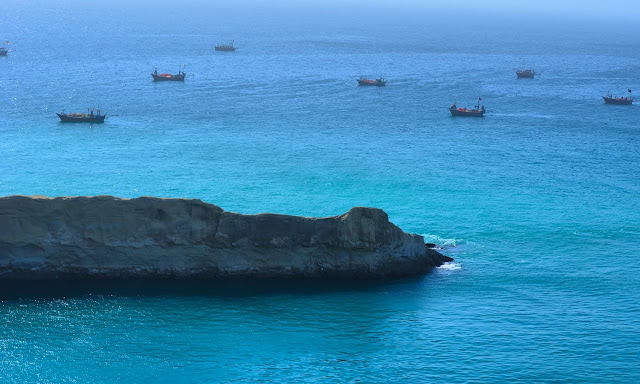
In the Arabian Sea, approximately 25 km off the coast of Balochistan, a large hidden uninhabited island lies, which is just 7 km long and 2.5 km wide. That is famous as Astola Island (Island of the Seven Hills) with sheer white cliffs surrounded by warm turquoise water. A beautiful slender white beach runs around the periphery of Astola Island. The cliffs shrink inland to make secluded cloves almost like in the Mediterranean.

It is also known as Jezira Haft Talar, which has long been Pakistan’s hidden gem. Astola Island is a mainly untouched site that has all the hallmarks of a tourist getaway. Many thanks to its remote location, the superb beauty has remained unblemished. In 325BC Alexander the Great has sent Arrian people to explore the Arabian Sea and Gulf Sea. However, the Sailors Fleet were frightened at the weird tales about a barren island. The Arrian called it Nosala, and also named it as Carmina, Karmine.

If someone wants to go to Astola Island, then he has to 7 hours of travel from Karachi to Pasni, almost 40 kilometers from Astola Island. Pasni is a seaport in the Arabian Sea, from here, the ultimate destination is 5 hours by boat. Astola the Pakistan largest offshore Island has no facilities only an old lighthouse and a small masjid.

Travelers who visit the secret place of Pakistan, usually camp at the beach and go snorkeling or deep-sea diving and enjoy it chasms and crevices, that is several feet wide. There are several natural caves and coves on the Astola island. The south side slopes off progressively whereas the north face is cliff-like with a sharp vertical drop.

Fisherman catching lobsters, crabs, and oysters between May and September. The best time to visit Astola Island in May and September when a gentle breeze blows throughout the day and the color of the water and pattern of the beach keeps changing with the tide. The water is so clear that one can see the seabed to a depth of about 20 feet. From Mid-June to Mid-August, the moon soon starts, which becomes Island is inaccessible by boat as the sea becomes too rough.

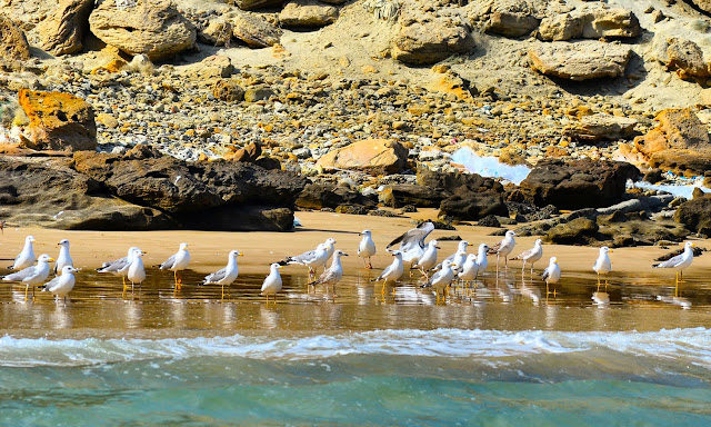
This is mostly a barren island due to the unavailability of freshwater, hence, you will not see too many trees there except a few bushes and scrubs. There is no vegetation on the Island. Nevertheless, plenty of marine life such as corals, dolphins, whales, and diverse fish species. The majestic sandy beaches offering nesting grounds for different bird species such as gulls, godwit, curlews, coursers, plovers, sanderling, endangered green sea turtle and the hawksbill turtle (Eretmochelys imbracata). Therefore, the saw-scaled viper (Echis carinatus astolae) is endemic to the Astola island.

Unfortunately, legal and illegal fishing activities has made big damage to the island’s ecology. The fishermen dump waste and wrecked nets on the coast that gets tangled in the corals and damage them. The sooty gull (Larus hemprichii) once had a main breeding colony on the Astola island, has been getting rid of because of rats introduced from a decade. However, the wild cats left the island to dig out turtle nests and eat the eggs and hatchlings. Furthermore, some ancient ruins of Hindu temple located on the Island known to the Hindus as Satadip.

In 2017, Pakistan declared Astola Island first-ever Marine Protected Area. However, this Asian country is yet to draw up a proper plan on how to handle pollution problems. Therefore, this declaration put some positive aspects, but the ignorance of management raises questions about the protection of the island and the associated biodiversity that is facing multiple issues. In 1982, the Pakistan Government installed a lighthouse on the island for the safety of passing vessels, eventually, it was replaced by a solar-powered in 1987.

The WWF for Nature in Pakistan argued that the development of a management plan for the Astola Island would take time. Pakistan needs to take some time into consideration the socio-economic aspects of local fishers and issues related to livelihood needs. Astola Island needs good practices to be promoted and bad practices should be discouraged. They believe that it is possible to protect the island’s ecology and biodiversity and at the same time promote ecotourism on the island.

Astola Island, Pasni Pakistan

Astola Island, Pasni Pakistan

Astola Island, Pasni Pakistan

Astola Island, Pasni Pakistan

Astola Island, Pasni Pakistan

Astola Island, Pasni Pakistan

Astola Island, Pasni Pakistan

Astola Island, Pasni Pakistan

Astola Island, Pasni Pakistan

Astola Island, Pasni Pakistan

Astola Island, Pasni Pakistan

Astola Island, Pasni Pakistan

Astola Island, Pasni Pakistan

Astola Island, Pasni Pakistan

Astola Island, Pasni Pakistan

Astola Island, Pasni Pakistan

Read More – The Tree of Life Kalaloch, Washington
Product You May Interested