Sunday, 23 February 2020

Scola Tower - Italy

Italy has a rich history of the fortress; hence every town has many ancient places to see. Scola Tower is one of them, a military building located in the province of La Spezia. The tradition and architecture of Scola Tower showcase rich history. It was built in the 17th century with large blocks of square stone that still stands 42ft tall in the sea. The main object to build this tower for the defense system of the senate of the Genoa in order to protect the coast, surrounding towns and villages.
The historian believed, the Scola Tower was made to accommodate 8 to 10 soldiers, comprising a Captain, a bomber, commanders, and their guards. Earlier this tower was also called “Torre di San Giovanni Battista” and “Tower of St. John the Baptist”. Early chronicles claim the tower was built at the cost of 56,000 Genoese liras.
The pentagonal shape tower has 4 feet thick wall. That is why the architecture of this tower still stands in the sea. In the 18th century, the naval battle between the British and Napoleon badly damaged the structure, eventually no other option to left it abandoned. As time passed, the tower lost its defense purpose, and authorities found the structure useless. In 1915, it was planned to demolish. But luckily Socla Tower kept saving by Ubaldo Mazzini an official of the Ministry of Public Education by realizing its historical value and make some structure improvement.
For many years, the tower was a place for the Italian Navy target practice. In the 20th century, travelers realized the value of old buildings and paying visits regularly. Therefore, the Italian government realize the importance of this historic tower and systematically restored between 1976 till 1980 to save the structure for future generations.
Eventually, it becomes a popular tourist attraction in Palmaria (island) in Porto Venere in the Gulf of Poets. The loneliest nature creates an opportunity for tourists to come here and enjoy the unforgettable surroundings of water. They can relax their mind and body to view the history of this beautiful tower. The dramatic and fascinating beauty is one of the most characteristic features in the Gulf of poets.
Moreover, it is an ideal place for photography in the shadow of ruined blocks. Many areas of tower are overgrown vegetation inside the interior and top of the tower, which is adding dazzling beauty to photographers.  


Thursday, 13 February 2020

The Museum of Death

The Museum of Death shows art and artifacts and several paintings of serial killers to shrunken heads. In June 1995, J.D. Healy and Catherine Shultz brought their rare collection of autopsy videos, pieces of taxidermy, skeletons, body bags, skulls, coffins, letters, many images sent by serial killers, and numerous death-themed oddities to the French quarter. 

The California based museum exhibits very dreadful graphics, not for faint-hearted or weak stomachs peoples. Although, no age barrier in the museum, as they said, “WE ALL DIE”, then why don’t be afraid, however, primary cautions and consideration are highly urged.

Normally, visitors hesitate to visit the Museum, but one who does the visit, get a free t-shirt, that marks the printing of “I passed out at the Museum of Death and Live to talk about it” and they call them “falling down ovations” at the museum. The museum notable item is the head of Henri Landru’s.

One of the dangerous suicide machines of Dr. Jack Kevorkian’s installed in the museum, along with a business card of Jack Ruby, who murdered Lee Harvey Oswald, who killed U.S. President J.F Kennedy. Several letters of notorious serial killer Jeffrey Dahmer and “Unabomber” & Ted Kaczynski. Also, a special room fixed to display taxidermy different types of animals.

The painting of serial killer John Wayne Gacy, and his hair recovered from the crime scenes from the O.J. Simpson trial and Manson Family pictures. Moreover, autopsies videos of death are not reenacted, happening on the screen, which is a big part of the reason for Healy’s warning about who should visit. Exhibits on terrorism, cannibalism, and embalming are included, as well as a collection of shrunken heads.

Normally, it takes about 45 minutes to view the museum of death. However, if anyone wants to take a long time if he wants too. But keep in mind, no pictures are allowed. The purpose to build this museum to educate people about death which is the ultimate event of human life. So, they should live life without the fear of death. The founders want to limb the conversation around death since too often it doesn’t come up until it is too late.

Annual CompetitionMoreover, the death of the museum holds a Black Dahlia look-alike competition annually. The participants dressed as both pre and post mortem Dahlia.

New Orleans BranchThe couple had opened a new museum branch in New Orleans, that is called "Musee de Mort Orleans" covering 12,000 square meters of space. Now the ample space allowing them to display more collections. This museum is surrounding the subject of death items.  

Product You May Interested


    Sunday, 9 February 2020

    Obelisk’s Perilous Voyage Egypt’s stone

    An Obelisk’s Perilous Voyage Egypt’s stone originally raised in homage to the sun have been coveted since Roman times as symbols of conquest and mysterious power. it is  Weighing an average of 150 tons, the granite pillars challenged those who would carry them off, as Sir James Alexander discovered in 1877.
    The obelisk of the Englishman’s attentions was Cleopatra’s Needle, sixty-eight feet tall It had been presented to England half a century earlier by the Egyptian ruler Muhammed Ali. Attempts to collect the prize in Alexandria, however, had met only with frustration. Bringing it home was a matter of pride for the patriotic Alexander.
    His solution was to encase the obelisk in a watertight iron cylinder and roll it to the sea on huge timber wheels. Once afloat, the cylinder was fitted out with a keel, rudder, deck, and cabin. Appropriately christened the Cleopatra, this strange vessel was hauled out to sea by the steamship Olga in September 1877.
    The journey was a harrowing one, marked by a gale that forced the captain temporarily to abandon his foundering ship Reclaimed and repaired, the monument glided into the Thames River on January 21, 1878, and was installed on the river’s banks.
    The obelisk remains there to this day, still invoking Egyptian sun-believers under London’s rainy skies.


    Product You May Interested
    1. Crush Food Cravings with Odd Water Hack and Melt 62lbs
    2. Flavor Pairing Ritual Supercharges Women’s Metabolisms
    3. The best Keto Diet Program
    4. Unlock your Hip Flexors, Gives you More Strength, Better Health & All-Day Energy.
    5. 21 Days Flat Belly Rapid Weight Loss System
    6. Fan Victor – The Ultimate Fantasy Sports Plug-in 
    7. 7 Instant Confidence Technique with Women Program

    Friday, 7 February 2020

    The Shona and Great Zimbabwe

    Further inland from the coastal cities, other Bantu groups were establishing powerful empires based on one of the region’s most precious and profitable resources: gold. During the 800s, a Bantuspeaking people called the Shona settled in the valley of the Limpopo River in southern Africa. By 1000, they had moved onto an area of rich farmland between the Zambezi and Limpopo rivers. There, the Shona established a thriving empire. Shona Empire The empire that the Shona carved out of the grasslands of southern Africa consisted of numerous Zimbabwe’s, or settlements encircled by large stone walls.
    The term Zimbabwe comes from a Shona phrase, dzimba dza mabwe, which means “houses of stone.” The ruins of about 150 such structures are scattered throughout the present-day southern African countries of Botswana, Mozambique, and Zimbabwe. Great Zimbabwe the largest of the Shona settlements was known as Great Zimbabwe. It was the center of the Shona empire.
    The city and its surrounding area covered more than 100 acres and had a population of 10,000 to 20,000 people. Geography played an important role in Great Zimbabwe’s rise. The region was surrounded by huge plains that the Shona used for farming and cattle raising. Great Zimbabwe was also located near key trade routes.
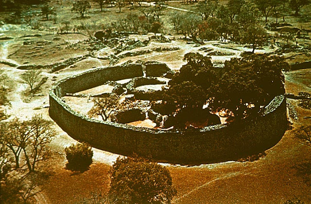
    There are three main sections of Great Zimbabwe: The Valley Ruins, the Hill Complex, and the Great Enclosure. The Great Enclosure is the largest and most significant of these sections. Archaeologists think that the Great Enclosure was used as a home for kings and queens. From the air, the Great Enclosure looks like a giant necklace. Its outer wall is about 820 feet around and rises as high as 36 feet. An inner wall runs along part of the outer wall.
    The two walls form a narrow passageway that leads to a 33-foot-high cone-shaped tower. The tower’s purpose remains a mystery. At one time, the enclosure contained elaborate buildings constructed of daga brick made from mud or clay. Shona builders cut stone blocks for the Great Enclosure’s walls from the granite hills around the city. They carved the blocks with such precision that nothing was needed to hold them in place. Many of the Great Enclosure’s walls are as smooth as a modern brick wall. The most elaborate walls probably date from the 1300s and 1400s.
    Great Zimbabwe the largest remaining section of Great Zimbabwe is called the Great Enclosure. Its maximum diameter is about the length of a football field, and its walls are about 36 feet high. 1 Scholars believe kings and queens lived in the Great Enclosure, while farmers and workers lived outside. 2 A passage between the outer and inner walls leads to a 33-foot cone-shaped tower.
    Historians speculate that it may have had religious purposes. Gold, Trade, and Decline Great Zimbabwe became an influential center of wealth and power due to the trade routes that passed through the city. The key product that traveled along these routes was gold. Gold was one of the main goods traded between Africa and the lands of India and China. Great Zimbabwe did not produce gold. However, it stood between the gold-producing regions to the west and the trading cities along the eastern coast. As a result, Great Zimbabwe’s leaders could tax those traveling the routes. They could also demand gold from the region’s less powerful leaders.
    The city became the center of the international gold trade. Scholars estimate that at its peak, travelers carried more than 2,000 pounds of gold through Great Zimbabwe every year. During the 1400s, Great Zimbabwe began to decline. Some historians say that drought and the overuse of grazing land caused a resource shortage. Others argue that people left to take advantage of shifting trade networks. Whatever the reason, Great Zimbabwe was abandoned by 1500.


    Product You May Interested
    1. Crush Food Cravings with Odd Water Hack and Melt 62lbs
    2. Flavor Pairing Ritual Supercharges Women’s Metabolisms
    3. The best Keto Diet Program
    4. Unlock your Hip Flexors, Gives you More Strength, Better Health & All-Day Energy.
    5. 21 Days Flat Belly Rapid Weight Loss System
    6. Fan Victor – The Ultimate Fantasy Sports Plug-in 
    7. 7 Instant Confidence Technique with Women Program

    Palmerston Island - Place at The End of Earth

    William Marsters
    The geographically far-flung Palmerston atoll was first sighted by Captain James Cook and his crew in 1774. The intrepid Yorkshire-born mariner gave it a wide berth on this first encounter but chose in any case (either cannily or obsequiously) to name it after Lord Palmerston.

    Returning three years later, and on his third voyage to these South Pacific parts, Cook and co. did indeed venture ashore seeking food and supplies. Thus, making Palmerston the only single island in the coral reef-bound Cook Islands to be graced by a visit of the great man himself. 

    The island was then uninhabited but in earlier times it had experienced brief periods of native occupation and was already known to the Polynesians as Ava Rau – which translates as something like the Place of 200 Channels. But one name really dominates Palmerston, that of William Marsters.

    At the last, all but three of the present residents of the island are direct descendants of Marsters. To call Palmerston a close-knit community is an understatement, to say the least. It is also an exceedingly small one: The population stands at just over sixty families, down from about 300 in the 1950s and 1960s.

    William Marsters, however, did get the place off to a running start by fathering twenty-three children with his three Maori wives. Hailing from Gloucestershire (or by some accounts Leicester), this English carpenter and cooper had wound up on Manuae Atoll, near Aitutaki after sailing across the Pacific from California. Where he’d headed in search of gold in the rush of the 1840s.


    Clearly a man given to taking a punt on a hunch, he accepted the position of caretaker of the island and sailed the 228 miles to it in 1863 with his first two wives. The third was acquired a short while later, and maybe even a fourth, too.

    Once on Palmerston, he procreated, hunted the bosun bird, fished for parrotfish (still a prized local delicacy and the island’s chief export) and planted palm trees to produce coconut oil and gathered sea cucumbers from the lagoon. The house he built from the timber of shipwrecks still stands today.

    And it was the only structure on the island to escape an appalling hurricane that swept everything else away in 1926. After a long tussle with the British government, William Marsters was eventually granted possession of the island by Queen Victoria in 1892 but died of malnutrition only seven years later after his coconut trees died of blight.

    Technically administered by New Zealand, Palmerston has its own government and Marsters’ descendants were granted full ownership of the island in 1954. Only their relatives can reside on the island. What they have, certainly aesthetically, is as close to a Pacific island paradise as you can get – hurricanes aside.

    Accessible only by boat and by a treacherous approach, this is a place of white sandy beaches, verdant palm trees and pandanus (a palm-like tree) and an abundance of coconut, taro, and breadfruit, all surrounded by a clear sea and a lagoon so plentiful with seafood that it serves as a kind of offshore kitchen, to be raided as the appetite demands.

    That said, the numbers of parrotfish have dwindled so much in the last twenty years that intermittent bans have had to be imposed to help numbers recover. The islanders take pride in the peace of their surroundings and the gentility and order of their society.

    Marsters was seemingly quite a severe and devout individual who schooled his offspring in Christian worship. The church continues to be the center of island life, and barter and exchange remain the main form of custom between islanders themselves. However, such a simple life over there, as no shops, no hotels, and no restaurants available. Most of the families are engaged with fishing occupation and collect rainwater for drinking water.

    Drinking water is chiefly derived from rainwater and plumbing is primitive to non-existent: there are two toilets on the island. Their main freighter supply ship visits just twice a year, also bringing with it rice and similar staples to be traded for frozen parrotfish and other islands produce.

    Slightly less isolated from the modern outside than it once was, Palmerston is on the internet. And electricity, previously rationed, is now available twenty-four hours a day, thanks to the installation of new solar panels in 2015. Home to the highest number of deep freezers per capita in the entire world.

    The Palmerston Island especially welcomed this innovation, its people fed up with losing the contents of their freezers whenever the power failed. PIA (Palmerston Island Administration) and Cook Islands government take care of the administrative matters.

    Moreover, fishing, tourism, copra, and bird feathers are the main economies. The basic and modern facilities are available on the island, like electricity, telephones stations, and cargo ships, but no airport. The island is full of coconut palms, pandanus, and native areas. The tropical climate, suits shellfish, parrotfish, and many other sea creatures.


    Saturday, 1 February 2020

    The Kabayan Mummies Caves - Benguet Philippines

    In ancient times, when life could be nasty, brutish and short. The doctor’s cures could be almost as deadly as any disease, and death was a constant presence. Since many unable to do much for the terminally ill other than speeding their eventual demise.
    Sometimes doing so exceedingly brutally, our ancestors nevertheless set a lot of store on preparing for the afterlife. The death rituals of the Ibaloi tribe of Benguet Province in the Philippines were positively involved and more strikingly since they required the considerable and active participation of the dying, too.
    For the Ibaloi, like the ancient Egyptians, mummified their dead, but they used a rather exclusive embalming technique. Their favored method of preservation was essential to cure the corpses with smoke and dry out the bodies until all that was left was a kind of desiccated husk of a human being. After that herb was rubbed onto the body. However, the process of dehydration started well before death.
    The terminally ill, accepting their fate with a certain equanimity would drink beverages heavily laced with salt, a fatal poison if ingested in anything other than modest quantities. Once the person was dead, the body was washed down with herbs and tobacco smoke was blown over it.
    And then into the mouth of the deceased by mourners before being hung above a smoldering fire for weeks on end. When mummification was complete the dead were ceremoniously laid to rest in oval-shaped wooden coffins carved with decorations and buried deep inside cave tombs.
    The Kabayan Mummies are also famous as, Ibaloi Mummies, Benguet Mummies, Fire Mummies can find at Kabayan town in the northern part of the Philippines. Researchers believe that Kabayan Mummies were created by the Ibaloi somewhere 1500 AD in Benguet and buried in Caves.
    However, some other Scientifics believe the process of mummification started in 2000 BC, shortly before a person died.  Eventually this brutal practice of that mummification over, since Spaniards colonized the Philippines in the 16th century.
    Many mummies were stolen by Westerners as caves were not protected in the early 20th century. A nonprofit organization (Monument Watch) declared this place one of the 100 most endangered heritage sites in the world. Also, a small museum made in Kabayan, Benguet, where some of the fire mummies display for visitors. Also, more than two hundred caves unearthed here and out of 15 them having fire mummies.
    This site is under consideration to declare the UNESCO World Heritage Site. Moreover, the burial caves in Kabayan town will collectively be called the Benguet Mummy Burial Caves or Mummy Burial Caves in Kabayan and Buguias. The locals are still fed fire mummies with chicken and gin, ensuring that they are having a good time life after death.


    Product You May Interested

    1. Crush Food Cravings with Odd Water Hack and Melt 62lbs
    2. Flavor Pairing Ritual Supercharges Women’s Metabolisms
    3. The best Keto Diet Program
    4. Unlock your Hip Flexors, Gives you More Strength, Better Health and All-Day Energy.
    5. 21 Days Flat Belly Rapid Weight Loss System
    6. Fan Victor – The Ultimate Fantasy Sports Plug-in 
    7. 7 Instant Confidence Technique with Women Program

    Friday, 31 January 2020

    No Man’s Land Fort, Portsmouth, England

    No Man’s Land Fort is a sea fort as long Shunned Coastal Bulwark the in Solent Portsmouth, England.  The poet John Donne said no man is an island, but No Man’s Land Fort is an island of sorts. One of four iron and granite structures, it is set like tarnished stones in the murky tidal waters of the Solent, a mile or so off the south coast of England.
    The main purpose of to build the No Man’s Land Fort is to give protection to Portsmouth and its harbor from French sea attack and bombardment. As perfect examples of robust, self-confident, enduring Victorian engineering as you could possibly find. They nevertheless speak volumes of the geopolitical anxieties of that age.
    Like Spitbank, Horse Sand and St Helens, No Man’s Land Fort was erected between 1860 and 1880. It was in direct response to very real fears of a potential threat of invasion from across the English Channel. However, many believe the construction work of No Man’s Land Fort started in 1865 along with Horse-Sands, and St Helen's.
    In 1860, the British Prime Minister, Lord Palmerston, established a Royal Commission on the Defense of the United Kingdom. Which recommended a substantial expansion of coastal bulwarks to protect naval ports such as Portsmouth.
    Squabbles over their cost would delay their completion and by the time No Man’s Land was finally up and operating it was largely irrelevant. Both it and similar forts were popularly dismissed as ‘Palmerston’s Follies’. However, the First and Second World Wars were to dent such naysaying attitudes, as they were re-armed and manned as vital coastal defenses.
    Therefore, decommissioned in the 1950s, No Man’s Land sat for years largely in a state of abeyance and used for coastal artillery until 1956. In 1960, it was decided to put on sale, but took 20 years to sold out by the Ministry of Defense in the 1980s and their parts fell into disrepair.
    Since 2008, it has since been revamped as a luxury hotel and party venue, with a helipad, a wine bar, billiard room, swimming pool, laser quest arena and guest rooms. Most decorated in a nautical theme, with portraits of Lord Nelson a charming addition to some.
    This is also called as “No Man's Fort” is 200 ft in diameter and lies 1.5 miles off the coast of the Isle of Wight, once housed more than 70 soldiers. In a 1972 serial The Sea Devils, many scenes were filmed at this fort. The Solent fort is capable of to accommodate 44 guests and 200 people at parties.


    Product You May Interested

    1. Crush Food Cravings with Odd Water Hack and Melt 62lbs
    2. Flavor Pairing Ritual Supercharges Women’s Metabolisms
    3. The best Keto Diet Program
    4. Unlock your Hip Flexors, Gives you More Strength, Better Health and All Day Energy.
    5. 21 Days Flat Belly Rapid Weight Loss System
    6. Fan Victor – The Ultimate Fantasy Sports Plug-in 
    7. 7 Instant Confidence Technique with Women Program