Tuesday, 23 February 2021

El Yunque National Forest Puerto Rico

 Popular day trip from San Juan, El Yunque combines all the magic of a rain forest majestic trees, giant ferns, and mysterious peeps and trills emanating from the dense foliage in the rugged Luquillo Mountains. As the only tropical rain forest in the United States National Forest System, El Yunque provides paved trails that are easy on children and inexperienced hikers. It even offers a drive-through option for windshield tourists who can enjoy the misty landscape and roadside waterfalls along Route 191, the only road through the 28,000-acre forest. But El Yunque, considered sacred by the Taino Indians, is indubitably best experienced on foot. This place is home to thousands of plants, including 240 tree species (23 of which are found nowhere else) and 70 orchids. El Yunque has 13 hiking trails covering 23 miles of varied terrain. 

The hardy can summit El Toro and take in spectacular 360-degree views of the forest, but even small children can handle the less-than-a-milelong Big Tree Trail that wends past La Mina Falls, whose cascades plummet 35 feet into a cool, refreshing pool of water the perfect plunge on a hot day. The 3-mile El Yunque Trail is considered the most rewarding. The farther away you can get from the cruise-ship crowds, the more jungle magic you’ll find. 

There are no large creatures here such as monkeys or panthers, but there are plenty of small ones that you may not see but will certainly hear. Millions of tiny coqui, the endemic tree frog that is Puerto Rico’s mascot, live here, trilling “co-KEE” sporadically until evening approaches, or after a rainfall when it turns into a full-blown chorus. The most prized sighting is the bright-green Puerto Rican SABA parrot, once abundant but now quite rare and highly endangered. After the rain forest, it’s only 8 miles north of Luquillo Beach, a much-photographed palm-lined crescent of white sand and calm turquoise waters that attracts lots of local families from San Juan. Follow them: They know which roadside stand sells the best alcapurrias, plantain fritters stuffed with seafood.


Tuesday, 2 February 2021

Darvaza gas crater in Turkmenistan

The Gates to Hell also known as “Darvaza gas crater” and Door to Hell in Turkmenistan. This is a natural gas field that accidentally collapsed into a cavern in the Darvaza drilling rig to fall in. It is believed that the geologists of Russia may have purposely set it on fire to stop the spread of methane gas. The Gates to hell having punctured pockets of gas, poisonous fumes started fumes leaking at an alarming rate.

However, many geologists think it has been burning continuously since 1971 and is expected to keep on burning. The Gates to Hell situated in the middle of Karakum Desert, approximately 160 miles from Ashgabat, the Capital city of Turkmenistan. The engineers thought, to be a substantial oil field site to access the oil quantity in this site. The closer you get, the brighter it glows. The Gates to Hell was a dot of light moments ago and is now a giant crater with fire coming out of it.
The Gates to Hell crater has an area of 5,350 m2 with a 226ft diameter and its depth is about 98 ft). It’s a popular tourist attraction in Turkmenistan. The beautiful wild desert camping is my favorite surrounding area. The fiery glowing Darvaza Gas Crater can be seen from miles. The nearby village “Derweze” captured the public imagination as a mystery named it Door to Hell due to continuous fire, boiling mud, and orange flames of the crater.
Surprisingly, regardless of the crater’s menacing name and ever-present dangerous flames, tourists still trek into the wild desert to witness the burning site in all its blazing glory.  In 2010, Turk president Gurbanguly Berdimuhamedow ordered the closure of the hole, to save the nearby towns from the dangerous release of poisonous gases however couldn’t due to various reasons. The Gates to Hell history is uncertain until 1960,s. After reviewing the samples of Gates of Hell soil, a crusty bacteria species discovered active at the bottom of the crater has the ability to live in high temperatures.


Sunday, 31 January 2021

Groom Lake, Nevada United States

Groom Lake is a dry Salt Lake in Nevada. It is used for runways of the Nellis Bombing Range Test Site Airport Part of the Area 51 USAF installation. The lake lies at an elevation of 4,409 ft and it is about 3.7 miles from north to south and three miles from east to west at its widest point and is about 11.3 miles in circumference. Located within the namesake Groom Lake Valley portion of the Tonopah Basin, the lake is 25 mi south of Rachel, Nevada.

The nearest publicly accessible vantage point is Tikaboo Peak, twenty-six miles to the east. There were two closer vantage points, dubbed "Freedom Ridge" and "White Sides", but they were closed to public access in 1995 to prevent people from taking pictures of the installation. In popular culture, Groom Lake is a location in the zombie’s maps "Moon" and "Classified" in the Call of Duty: Black Ops franchise.


Groom Lake lead and silver were discovered in the southern part of the Groom Range in 1864. The English Groome Lead Mines Limited company financed the Conception Mines in the 1870s. That is giving the district its name (close mines included Maria, Willow, and White Lake). The mining claims in Groom were acquired by J. B. Osborne and partners and patented in 1876, and Osborne's son acquired the interests in the 1890s. The claims were proved in 1916 when two companies began working their mines; that work continued until 1918 and resuming after World War II until the early 1950s. Mineral production within the quadrangle has been principally leading and silver from the Groom mine in the Groom Range and silver from the Kelly mine located in the Pint- water Range south of Groom.


Papoose Lake is a dry lake bed located in Lincoln County, Nevada, U.S.[1] The lake lies within the plot of land referred to as the Groom Lake facility (also known as Area 51) and is a restricted area. The lake is located a few miles southwest of the Groom Lake facility nestled adjacent to the Papoose Range.


Geological Setting


Rocks within the Pahranagat Range Quadrangle range in age from Precambrian through Tertiary.  Precambrian rocks crop out mainly in the western portion of the quadrangle and consist of shale, siltstone, and silty limestone of the Johnnie Formation and quartzite, siltstone. The thin beds of limestone of the Sterling Quartzite in the Half-pint and Groom Ranges. Rocks in the Papoose Range to be Cambrian age. Maybe Precambrian and correlate with those in the Groom Range to the north. Paieozoic quartzite, shale, and carbonate units are present in most of the ranges within the quadrangle but the most extensive Paleozoic exposures are in the Pahranagat, Desert, and Pint water Ranges.


Tertiary volcanic units, including andesite and basalt flows, welded ash-flow tuffs. The intervocalic sedimentary units cover portions of the Hiko, Pahranagat, Groom, and Half-pint Ranges. The only intrusive rocks mapped within the quadrangle are porphyritic rhyodacite dikes, sills, and stocks in and adjacent to Bald Mountain in the central Groom Range. The major regional structural features exposed within the quadrangle are thrust faults and northeast-striking strike-slip faults. There were at least two periods of thrust faulting, Laramide and probably Cretaceous or Eocene.


One-third of the area of pre-tertiary outcrops in the quadrangle is underlain by major thrust faults. The most prominent structural feature of the area is the Pahranagat shear zone, composed of northeast-striking faults with apparent strike-slip movement. Faults related to this regional structure pass through the Southeastern district at the north end of the Pint water Range. The south end of the Pahranagat Range, and possibly between the Groom, Papoose, and Desert Ranges, have defined a caldron centered on Bald Mountain in the Groom Range. Volcanic rocks in the Groom Range and the adjacent Desert Range may have originated from this caldron.


Wednesday, 11 November 2020

Devon Island - Largest Uninhabited Island in the World

Devon Island is the largest uninhabited island in the world. This is situated in Baffin Bay, Qikiqtaaluk Region, Nunavut, Canada. It is one of the largest members of the Canadian Arctic Archipelago, and the 2nd largest of the Queen Elizabeth Islands. This is Canada’s 6th-largest island and the 27th-largest island in the world. It has an area of 55,247 km2 slightly smaller than Croatia.

The bedrock is Precambrian gneiss and Paleozoic siltstones and shales. The highest point is the Devon Ice Cap at 1,920 m which is part of the Arctic Cordillera. Devon Island contains numerous small mountain ranges, such as the Treuter Mountains, Haddington Range, and the Cunningham Mountains. The distinguished similarity of its surface to that of Mars has attracted interest from scientists.
In the early 16th century, Robert Bylot and William Baffin were the first Europeans to sight the island. After Devon in England, a name which was changed to Devon Island by the end of the 1800s. In 1924, an outpost was established at Dundas Harbour. That was leased to Hudson’s Bay Company in 1933. The collapse of fur prices led to the dispersal of 53 Baffin Island Inuit families on the island in 1934. It was considered a disaster due to wind conditions and the much colder climate, and the Inuit chose to leave in 1936.
Dundas Harbour was populated again in the late 1940s, but it was closed again in 1951. Only the ruins of a few buildings remain. Because of its relatively high elevation and its extreme northern latitude, it supports only a meager population of muskox and small birds and mammals; the island does support Hypolite communities. This island is the most interesting place on planet earth, as its desert setting and severe climate are very alike to conditions on Mars.
Animal life is concentrated in the Truelove Lowland is a polar oasis area of the island, which has a favorable microclimate and supports relatively lush Arctic vegetation. The green area supports animal life, such as foxes, muskoxen, and polar bears. The ground remains frozen for almost the entire year, however temperatures during the brief (35 to 55 days) growing season rarely exceed barely 8 °C, and in winter it can plunge to as low as −55 °C.
With a polar desert ecology and a glacier is in the vicinity. Devon Island Canada receives very little rainfall. In simple words, Devon Island Canada is a wasteland. Cape Liddon is an Important Bird Area (IBA) noteworthy for its black guillemot and northern fulmar populations.
Cape Vera, another IBA site, is also noted for its northern fulmar population. Devon Island is also distinguished for the presence of the Haughton impact crater, created some 40 million years ago when a meteorite about 2 km in diameter crashed into what were then forests. The impact left a crater around twenty-three km in diameter, which was a lake for several million years.
In 1960, The Devon Island Research Station was established, and it is maintained by the Arctic Institute of North America. It is in Truelove Lowland, on the northeast coast of Devon Island. The Flash line Mars Arctic Research Station project entered its third season in 2004.
Since 2004, this Island became a brief home for five researchers and two journalists, who were to use the Mars-like environment to simulate living and working on that planet. The years 2007 was the longest simulation period that consists of 20 scientific studies. Diesel-powered generators supply power to the cabins as required; a tool shed and “sauna” are on site.
The Haughton crater is now considered one of the world’s best Mars analog sites. It is the summer home to NASA’s complimentary scientific program, the Haughton–Mars Project. HMP (Haughton Mars Project) has conducted geological, hydrological, botanical, and microbiological studies in this punitive environment since 1997. HMP-2008 (Haughton Mars Project was the twelfth field season at Devon Island.
In 2007, fossils of the seal ancestor were found on the island. On July 16, 2013, the Canadian Space Agency assigned Canadian astronaut Jeremy Hansen to secondment with the Centre for Planetary Science and Exploration of the University of Western Ontario at Haughton Crater in preparation for a potential future manned exploration of Mars, the Moon, or the asteroids. Recommended Reading –  Cleft Island


Sunday, 1 November 2020

Log Hollow Falls, North Carolina - United States

 Log Hollow Falls is a 25ft stunning waterfall in the Pisgah National Forest, Transylvania County, Carolina. It is also known as “Falls in Log Hollow”, or the Falls on Log Hollow Creek. Log Hollow Falls is a steep cascade with several sections of free-falling water. Tourists can drive to within half miles of the falls, and access them via an old Forest Service logging road. Therefore, this pretty waterfall is making it an easy destination. Regardless of this, Log Hollow Falls isn't very popular and receives a small number of visitors. You can call it a hidden jewel not explored by many.

There are many waterfalls in this stop, however, four are popular in close proximity to one another. Two are kid-friendly, that is Log Hollow and Logging Road Falls and two require a bit of scrambling effort to get to. That is Upper Log Hollow Falls and Discovery Fall. A right curve into a slide over a band of orange rock, and a nice pool at the bottom. The natural setting is lush green with plenty of wildflowers and bird sounds. This is a fun place for family and great for nature photography.

Moreover, you can also visit a nearby 80ft waterfall just a quarter mile past Falls in Log Hollow. But make sure, no signs are there for exact directions. It is an easy one-mile round trip from Forest Service Road 5043 that is most nearby to vehicles. It is located off a one-lane unpaved road. In July and August, you can enjoy plenty of wild blackberries along the trail. If you want to enjoy real nature sedateness, then this is a perfect place. The road is often closed from January till March.


Thursday, 22 October 2020

Oxarárfoss Waterfall Iceland

 Oxararfoss (or more accurately) Öxarárfoss Waterfall Iceland is situated in Þingvellir National Park. The stunning 20-meter waterfall flows from the river Öxará over the Almannagjá. The pool at the base of the waterfall is filled with rocks During winter the water is extremely icy cold. However, in the summer the water is climatic to body temperature. There is a beautiful pool at the base of the Oxararfoss waterfall. 

This is one of the major historic attractions to the UNESCO World Heritage Site of Þingvellir National Park. There is a path from the nearby car park leading up to it. Oxararfoss waterfall meaning “Axe Falls” how the waterfall and river (Öxará) got their names. During the settlement period, some settlers saw a frozen river. They then dug a hole in the ice and put an axe in it to claim the land. The area is administered by the municipality of Bláskógabyggð.

According to Wikipedia “An edited photograph of the waterfall by David Carson is used as the cover of Nine Inch Nails' album The Fragile.” Many historians believed this was actually an artificially created waterfall due to water diversion several centuries ago to provide better access to drinking water for the assemblies or Þing. Therefore, the water diversion creates a drowning pool that one can see while touring the site. Some superstition prevailed among peoples, that a drowning woman accused of infanticide, adultery, or some other crimes.

Oxararfoss Waterfall Iceland is a busy, but interesting and scenic walk through Icelandic history with some gorgeous lichen and wildflowers. A great place to stop for lunch if you’re doing a day of hiking. The area is separating the North American and Eurasian tectonic plates. Lots of fissures and basalt formations. Definitely a good place to bring the family if you want to go for a little hike but not spend too much energy on it. Hence one can see much taller, beautiful, magnificent waterfalls on Iceland's Southside.


Oxararfoss (or more accurately) Öxarárfoss Waterfall Iceland is situated in Þingvellir National Park. The stunning 20-meter waterfall flows from the river Öxará over the Almannagjá.

Thursday, 10 September 2020

Gouffre de Padirac, France

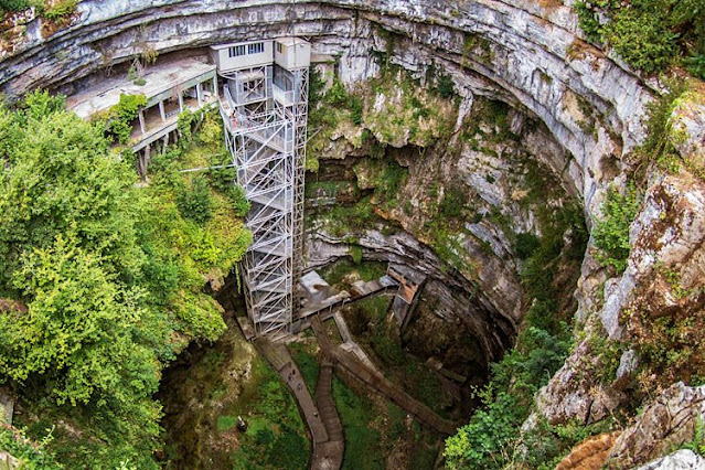
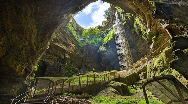
The Padirac Chasm is a cave situated near Gramat, in the Lot department, Occitanie region, France. In French Padirac chasm is called Gouffre de Padirac itself is 338 ft deep, with a diameter of about 33 108 ft. Tourists descend 75 m via a lift or a staircase before entering into the cave system. The Padirac Chasm comprises a subterranean river system that is partly negotiable by boat and is viewed as one of the most extraordinary natural phenomena of the Massif Central. This beautiful cave was created at an undetermined point in time when the roof collapsed into a large internal cavern.

It is known that the cavern existed in the 3rd century and was inhabited during the 15th and 16th centuries during which time Potassium nitrate was excavated from the area. In 1898, The first tourists visited the cave. In April 1899, Georges Leygues, the 87th the prime minister of France, officially opened the site for tourism. Today, although the cave system is made up of more than 40 km of galleries, only 2 km have been opened for tourism. Padirac Chasm was truly also one of the first tourist sites in France in the 19th century!

Since the 1930s, guests can access the cave system by descending 75 m by lift or stairs and then exploring the cave system on foot and by boat. Padirac Chasm is the most regularly visited underground tourism facility in France. Furthermore, 350,000 visitors annually, and a record of 460,000 in 1991. The cave was first explored, in 1889, by Édouard-Alfred Martel. Much of the credit for opening the cave system is owed to Guy de Lavaur, who came to Padirac in 1938 and managed to penetrate 15 km of the passages. Visitors can plunge into the depths of one of the largest chasms in Europe and take a boat ride on an underground river to explore the most extraordinary caves in the Dordogne Valley.

Also, the Natural cavern of 33 meters in diameter formed when the roof collapsed. Also, the 500 meters further, tourists continue the circuit on foot via a series of lovely rooms.  the Rain Lake and the pendant-like Pendeloque stalactite, the Salle des Grands Gours with a lake, and then the Salle du Grand Dôme with its impressive 94-meter-high ceiling. All these natural formations are breathtaking. Imposing and impressive in size and loveliness, the Great Dome Room is a real mineral cathedral. This enormous sinkhole has carved out remarkable caverns in the limestone, full of massive stalactites and stalagmites deep under the ground then punt along a subterranean river of pristine turquoise water. 


Product You May Interested