Wednesday, 13 May 2020

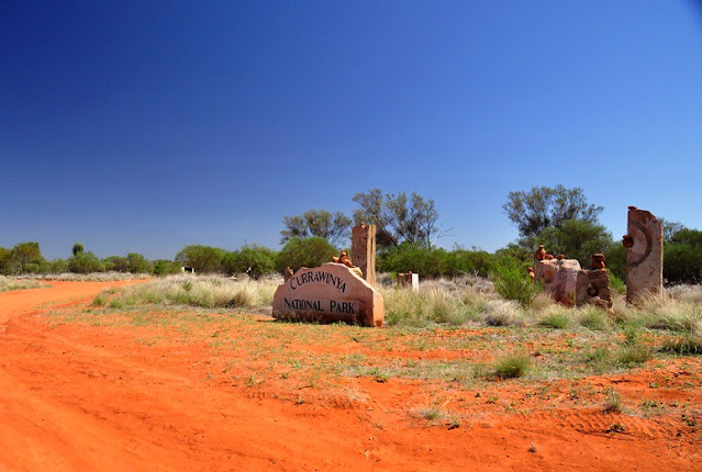
Currawinya National Park, Queensland, Australia

Two vast lakes — Wyara and Numalla — are the centerpiece of 154,870 ha Currawinya National Park, but they are not the only reasons to visit. Currawinya is rich in nature and cultural heritage. Visitors can bird watch, fish, or enjoy the solitude of camping beside the Paroo River.

Access

Near Hungerford on the Queensland/New South Wales border, all access roads to Currawinya are unsealed and impassable when wet. A 4WD vehicle is recommended.
From Cunnamulla, drive 70 km south-west to Eulo, then a further 4 km west before turning south towards Hungerford. The final 97 km to the park office takes 1 to 1.5 hours to drive.
From the south, enter the park via Hungerford, 217 km north-west of Bourke. The park office is 20 km north of Hungerford. Access is via working pastoral properties. Take care to avoid stock on unfenced roads and leave gates as you find them.
Hence, respect the rights of property owners. After good rains (either locally or far upstream) flooding isolates the park for long periods and can submerge campsites along the Paroo River. Therefore, you need to check conditions before traveling and always carry extra supplies in case of stranding. The nearest fuel and supplies are located at Cunnamulla and Thargomindah.

Camping

Bush camp at Ourimperee Waterhole is behind the Woolshed (close to flushing toilets and a bush shower), or at sites on the Paroo River near Caiwarro at the park’s northern end.

Currawinya’s Lakes

Currawinya National Park is a wetland of international importance under the Ramsar Convention. Currawinya’s lakes are important breeding and refuge sites for a spectacular array of water birds, including waders migrating from across Australia and the world.
Currawinya’s wetlands regularly support up to 100 000 water birds. Of particular importance are lakes Numalla and Wyara — no other wetland complex in arid or southern Australia is thought to consistently support such large populations of water birds.
Separated by only a few kilometers of sand dunes, each has different water conditions. Lake Numalla receives floodwaters more frequently from the Paroo River and is usually permanent. It holds freshwater, while the slightly larger Lake Wyara is saline and regularly dries to a vast, white clay pan.
Different bird communities live on each of the lakes at different times. Lake Wyara supports a greater number of water birds while Lake Numalla has a greater diversity. Smaller waders and plant-eating water birds feed in the clear, salty waters of Lake Wyara, which has more aquatic vegetation and invertebrates.
Shallows are the home to sandpipers, godwits, snipes, rails, dotterels, and stilts. At times thousands of black swans, coots, and grebes can be seen; as can ducks—including Pink-eared, hardhead, black and wood ducks, and the rare freckled duck. Lake Wyara provides a safe breeding ground for red-necked avocets, silver gulls, Caspian terns, cormorants, black swans, Australian pelicans, and many other species.
Pelicans that breed at Lake Wyara often fly to Lake Numalla and other surrounding lakes (including Lake Bindegolly 80 km away) to feed. Large waders and fish-eating species prefer the turbid (muddy) waters of Lake Numalla. Egrets, herons, cormorants, ibis, plovers, and brogans are most common. When seasonal waterholes, lakes, and clay pans fill after good rains, water birds scatter across the park. Spoonbills, great egrets, and straw-necked ibis can be seen.

Keeping Watch on Currawinya’s Birds

Researchers from the University of Newcastle and rangers have been studying the effects of the changing water levels and conditions of birds in these outback lakes. When water levels are low, lake water can be 10 times as salty as seawater, yet when full the water can be quite fresh.
High plankton levels lead to an influx of filter-feeding birds such as Pink-eared ducks. During drought, more than 10 000 freckled ducks have been seen. Researchers have also been studying breeding colonies of pelicans and other bird species.
Moreover, a study of Lake Yumberarra, a smaller lake that is fresh or salty depending on the season, has recorded 58 of Currawinya’s known waterbird species. It has more species than the larger lakes.

Things to Do

Learn about the park - Visit the information display at the turnoff to the park office.

Drive to the Lakes

See some of inland Australia’s most important wetlands and the variety of mulga lands’ habitats along the way.  A 4WD vehicle is needed for the 85 km round trip from the park office to lakes Wyara and Numalla. The road may be closed after rain.

Walk to the Granites

Take the Boorara Road for 10 km north of Ten Mile Bore where a short walk leads to a small granite outcrop. Views from atop the outcrop extend over the park. Walk carefully—the track is uneven and rocks may be slippery. Carry drinking water.

Value Heritage

Currawinya has a large number of sites significant to Aboriginal people. These and any associated artifacts are protected by law—please respect this and leave areas and artifacts as you find them.
Lakes and waterholes are of particular importance to the Traditional People of this area and those from neighboring areas, especially as gathering places during the waterbird breeding season. Heritage enthusiasts should visit the old Caiwarro homestead site, 37 km north of the park office.
Bulldozed prior to the pastoral property becoming a national park, the remains of several buildings, including a levee bank and machinery can still be seen. Please take care near ruins and treat such reminders of our pastoral history with respect. Visit Hungerford where the historic Royal Mail Hotel, built-in 1870,  still operates.

Boating and Fishing

Fishing is permitted along the Paroo River and in selected areas of Lake Numalla. See the ranger or on-site signs for details. Only live bait caught within the Paroo River system can be brought into the park.
Canoeing, kayaking, and swimming are permitted on Lake Numalla; however motorized boats and jet skis are not permitted on any of the lakes. Signs at lakes Wyara and Numalla show the activities permitted in particular areas.

Along the Paroo River 

This 600 kilometer-Long River has a catchment of over 70000 square kilometers and is the last free-flowing river in the Murray–Darling Basin. In wet times it forms a floodplain of over 800 000 ha. In the dry season, the river becomes a string of waterholes such as Ourimperee and Corni Paroo waterholes in Currawinya National Park.

Wildlife Watching

The variety of landscapes and permanent water make Currawinya rich in wildlife. Kangaroos, wallaroos, and emus are readily seen. Reptiles are plentiful, as are birds of prey. Currawinya is home to more than 200 species of birds. Spot Major Mitchell’s cockatoos, mulga parrots, Chestnut-crowned babblers, orange chats, White-plumed honeyeaters, and splendid fairy-wrens.
Along the river, look for water rats hunting small animals in the early morning and evening.  During the day whistling kites dive into the water to scoop up fish while rufous night-herons roost on shady branches nearby. After dark, little pied bats skim for insects just above the water surface.
Currawinya also has a small population of the greater bilby. Captive-bred bilbies have been reintroduced to Currawinya inside a 25 square kilometer predator and feral animal-proof enclosure funded by public donations and built with the assistance of volunteers. Visitors to Currawinya cannot visit the bilby fence or see bilbies, but can learn about them and the re-introduction project from a display near the woolshed.

Exploring the Landscape

Lake Wyara is lined by salt-tolerant samphire plants, whereas black box, river cooba and boobialla border Lake Numalla and many, smaller temporary lakes. Channels and floodplains of the Paroo River and other creeks are fringed with yapunyah, coolibah, and river red gum.
Elsewhere, mulga dominates the sandplains. Turkeybush Eremophilaspp has gradually replaced understorey grasses and is a subject of ongoing scientific research. The pungent aroma of gidgee fills the air before, during, and after rain. Poplar box, beefwood, emu apple, leopardwood, and whitewood are common trees.
Uncommon and vital shrubs and trees include inland belah Casuarina cristata subsp. pauper, Melaleuca densispicata, and black blue bush Maireana pyramidata. Low-lying eroded dune fields are dominated by shrublands of turpentine and hop bush; whereas ‘Bastard’ mulga and lancewood grow on Hoods Range in the park’s north.
Currawinya National Park, Australia

Currawinya National Park, Australia

Currawinya National Park, Australia

Currawinya National Park, Australia

Currawinya National Park, Australia

Currawinya National Park, Australia

Currawinya National Park, Australia

Currawinya National Park, Australia

Currawinya National Park, Australia

Currawinya National Park, Australia

Currawinya National Park, Australia

Currawinya National Park, Australia


Product You May Interested

Saturday, 9 May 2020

The Mysterious Crooked Bush of Saskatchewan

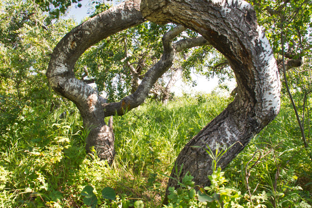
The Crooked Bush, Crooked Trees, or Twisted Trees and the Crooked Trees of Alticane are a grove of deformed trembling aspen trees of type Populus tremuloides Michx in Saskatchewan, Canada. They are usually reaching this height after 15 years. Crooked Bush is found approximately 20 km north-north-west of the town of Hafford, Saskatchewan and 5 km south-west of Alticane. These trees are noticeably different from the un-twisted aspens just across the road.

Therefore, explanations have been offered which include a variety of paranormal factors. Though, cuttings from these trees, exhibit the same pattern of twisted growth, signifying that the cause is rooted in genetics, possibly the result of a mutation. Thus, the trees' strange appearance was observed in the 1940s and attracted the tourists for many decades. However, the proliferation of websites and blogs that mention them gives a lot of hype.

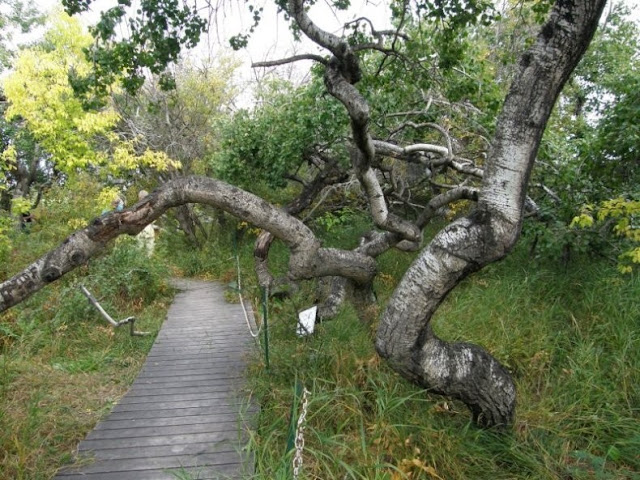
A wooden walkway was constructed through the grove to keep visitors from trampling any new growth. Since the deformity is probable genetic and aspens spread by root suckers, it is likely that all the crooked trees in the grove are clones that originated from a single mutated tree. The grove is at present bounded on all sides by the grid road and a perimeter access road, so the size of the grove is static and is unlikely to continue spreading.

The grove can be seen in the Disney's true-life adventure-fantasy film Perri in 1957. This area is considered as a natural treasure, so be in limits and don’t climb the trees, break branches, litter, or leave the boardwalk. This will support and ensure that the area remains intact for years to come. The average height of crooked trees is 15 to 20 ft and 75 years old.  

Different theories are popular about how it came to be. Some legends believe there is something in the soil, some contaminants that came when a meteorite crashed into the area. However, some believe it was a lightning strike.

What is truly fascinating is the fact that the trees are growing at a normal rate. Their branches are just growing in every direction other than straight up. While the trail is rather short, it features a wooden boardwalk and is an awesome destination for people of all ages and abilities. Summer is a perfect time to visit as new leaves are sprouting.

A picnic bench is installed there to relish the foods and there is no hiking location. There are different kinds of bird species to live in that area offers you relaxing nature music. Rick Simmonds, the owners of this property, upon which the crooked cluster of trees sit, this place is visited more than five thousand visitors each year, and numbers are growing every year. So, it is very imperative for people to understand and realize the uniqueness of this area to preserve and there isn’t another bush like this,

Crooked Bush, Crooked Trees Alticane are a grove of deformed trembling aspen trees of type Populus tremuloides Michx in Saskatchewan, Canada.

Crooked Bush, Crooked Trees Alticane are a grove of deformed trembling aspen trees of type Populus tremuloides Michx in Saskatchewan, Canada.

Crooked Bush, Crooked Trees Alticane are a grove of deformed trembling aspen trees of type Populus tremuloides Michx in Saskatchewan, Canada.

Crooked Bush, Crooked Trees Alticane are a grove of deformed trembling aspen trees of type Populus tremuloides Michx in Saskatchewan, Canada.

Crooked Bush, Crooked Trees Alticane are a grove of deformed trembling aspen trees of type Populus tremuloides Michx in Saskatchewan, Canada.

Crooked Bush, Crooked Trees Alticane are a grove of deformed trembling aspen trees of type Populus tremuloides Michx in Saskatchewan, Canada.

Crooked Bush, Crooked Trees Alticane are a grove of deformed trembling aspen trees of type Populus tremuloides Michx in Saskatchewan, Canada.

Crooked Bush, Crooked Trees Alticane are a grove of deformed trembling aspen trees of type Populus tremuloides Michx in Saskatchewan, Canada.

Crooked Bush, Crooked Trees Alticane are a grove of deformed trembling aspen trees of type Populus tremuloides Michx in Saskatchewan, Canada.

Crooked Bush, Crooked Trees Alticane are a grove of deformed trembling aspen trees of type Populus tremuloides Michx in Saskatchewan, Canada.

Product You May Interested

Friday, 8 May 2020

Kaaterskill Falls, USA

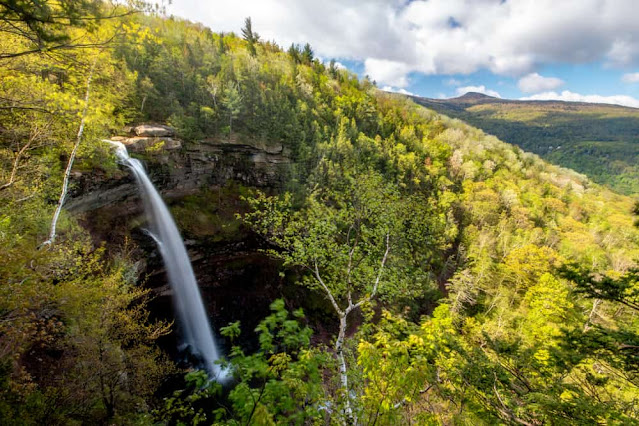
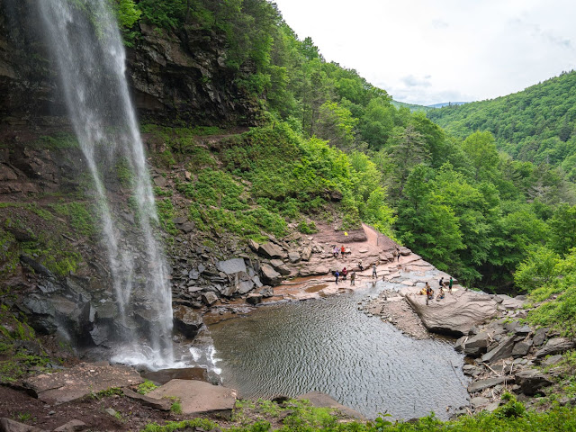
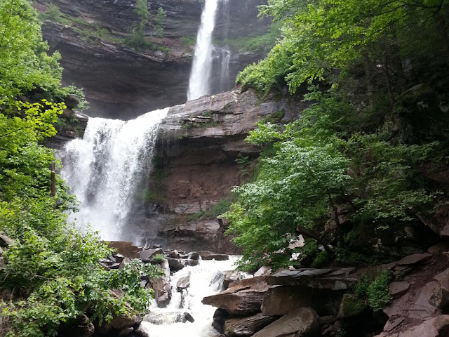
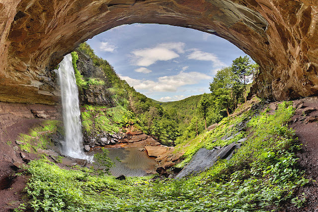
Kaaterskill Falls is a two-stage waterfall on Spruce Creek in the eastern Catskill Mountains of New York, between the hamlets of Haines Falls and Palenville in Greene County. The two cascades total 260 feet (79 m) in height, making Kaaterskill Falls one of the highest waterfalls in New York, and one of the Eastern United States' tallest waterfalls. 
The falls, like the clove and creek with which they share a name, is a relatively recent addition to the Catskills in terms of geologic time. They evolved through stream capture at the end of the Illinoian Stage when runoff from the glacial melt that created North-South Lake began to flow away from the nearby headwaters of Schoharie Creek and down the steep slopes of the newly created clove. The rushing waters of what would become known as Spruce Creek eroded a natural amphitheater at roughly 2,000 feet (609 m) on the south slope of South Mountain. While the falls' existence was known by indigenous peoples of the Hudson Valley prior to European colonization, it had a minor role for them, who generally avoided the Catskill Mountains due to the limited agricultural possibilities of higher elevations, though they occasionally ventured into the mountains to hunt game. Thomas Cole populated the falls with an occasional Indian in his earliest paintings 
For those not able to get too close to it, the waterfalls can be seen in their entirety in the distance from the northern approach to the summit of Kaaterskill High Peak, across the clove, and sometimes even from the fire tower on Hunter Mountain. The Kaaterskill Falls Trail was built during 1967 as the southern terminus of the popular Escarpment Trail, which runs along the ridge that bounds the Catskills to the northeast. During the late 1980s, DEC had to close the trail above the falls and build a new southern section along Schutt Road to limit the state's liability for injuries and fatalities that occurred near the falls.
Kaaterskill Falls, USA

Kaaterskill Falls, USA

Kaaterskill Falls, USA

Kaaterskill Falls, USA

Kaaterskill Falls, USA

Kaaterskill Falls, USA

Kaaterskill Falls, USA

Kaaterskill Falls, USA

Kaaterskill Falls, USA

Kaaterskill Falls, USA

Kaaterskill Falls, USA

Thursday, 7 May 2020

Amguid Crater Algeria

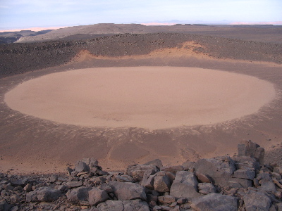
In the inaccessible region of southwestern Algeria, there is a meteorite crater named Amguid Crater. This is roughly 65 meters deep and around 500 to 530 meters in diameter (measured with Google Earth). Amguid Crater is approximately 100,000 years old and is maybe Pleistocene. However, more research required to identify the exact age. In 1948, this crater was unearthed by a few Europeans.
However, in 1969 the first scientific description was given by French geologist Jean-Phillippe Lefranc, who reached with a lot of efforts and positive energy. Roman Karpoff a French explorer noticed the possible impact of the crater from a plane in 1948.
Amguid Crater Algeria

Amguid Crater Algeria

Amguid Crater Algeria

Amguid Crater Algeria

Amguid Crater Algeria


Saturday, 2 May 2020

Turkish Hotel “Floats” Over 2,300-Year-Old Ancient Ruins


An astonishing new extravagance hotel opened in Antakya, Turkey in 2020. Amazingly it is at once an engineering wonder, an architectural attractiveness, and a world-class archaeological site.  In 2009 a construction crew was digging the foundation for a new hotel and surprise to see an amazing discovery at Antakya Turkey. The digging crew unearthed a gigantic mosaic of Roman times, along with over 35,000 artifacts ranging 2,300 years from at least 13 diverse civilizations.

This the amazing discovery put the hotel construction on hold however; they have completed six months' excavation work. Hence, the dreams of building a hotel dashed, potentially derailing the entire project. But a group “AsfuroÄŸlu” decided against that, and embrace the daunting challenge, they work hard with archeological find into the hotel’s blueprint.

So, they started to work with the Antakya Municipality, Hatay Archaeology Museum & Adana Conservation Council for Cultural and Natural Assets on Turkey's leading systemic archeological excavation since the 1930s. So, negotiation took place 11 years to conclude a final result of building the hotel come into being. Finally, the 200-room Museum Hotel Antakya opened its doors for customers.

The Hotel Antakya was designed by Turkish architect Emre Arolat. The five floors are balanced on near 20,000 tons of structural steel four times more than the Eiffel Tower columns on top of the actual archeological site. Where the eleven thousand square feet Roman mosaic lay in-situ.

The hotel’s Antakya lowest floor houses an open-air museum with glass floors and walkways providing a superb and clear view of the mosaic and the various excavation pits. The visitor rooms are massed above this open space, hovering over the site in a stacked honeycomb structure, with glass windows, straight overlook the archaeological findings.

The Ancient City of Antioch

The whole story started in 2009 when the famous city of Antakya stands on the site of the ancient city Antioch, founded in the 4th century BC. At those times, this region was the center of the Seleucid kingdom until the 1st century BC, when it was annexed by Rome and was made the capital of the Roman province of Syria.

Antioch was once the third-largest city of the Roman Empire in size and significance, after Rome and Alexandria, and possessed superb temples, theatres, aqueducts, and baths. Antioch was also one of the earliest centers of much ecclesiastical significance in the Byzantine Empire. However, the city changed hands more than a few times, conquered by Byzantine, Seljuk,  Crusaders, Ayyubid, Mamluk, finally the Ottoman in the 16th century.

Therefore, the archaeologists trust the mosaic may once have been part of a government building or a villa dating back to the 5th century. Thus, the other artifacts found inside date back to the Hellenistic Age, which started in 323 BC. Moreover to the mosaic, which the biggest single-floor mosaic ever found, archaeologists exposed ruins of a Roman bath, the first unbroken marble statue of the Greek Eros, and several more artifacts.

The project is completed after a hefty amount of $120 million and took 10 years to complete, just from the perspective of the hotel but also for the impressive archaeological findings. The AsfuroÄŸlu family anticipating, that what they would have found or how it would have changed the destiny of the region forever.


Product You May Interested

  1. Crush Food Cravings with Odd Water Hack and Melt 62lbs
  2. Flavor Pairing Ritual Supercharges Women’s Metabolisms
  3. The best Keto Diet Program
  4. Unlock your Hip Flexors, Gives you More Strength, Better Health and All-Day Energy.
  5. 21 Days Flat Belly Rapid Weight Loss System
  6. Fan Victor – The Ultimate Fantasy Sports Plug-in 
  7. 7 Instant Confidence Technique with Women Program