Tuesday, 25 July 2017

The Stone Mushrooms of Beli Plast, Bulgaria

Stone mushrooms” is a natural phenomenon in Bulgaria. It is located 1 km from the village of Beli Plast, on the road between the towns of Haskovo and Kardzhali. These rocks are natural limestone formations with height of up to 3 meters; occupy an area of about 30 acres. Stone mushrooms are one of the more unique and whimsical rock formations you’ll ever see. Of course, it takes hundreds of years of erosion for that process to be complete; formations like the aptly named Turnip Rock in Michigan or Jug Rock in Indiana bear a distinct resemblance to mushrooms. But the stone mushrooms in Beli Plast, Bulgaria are extremely unique, as entire clumps of massive stone pillars grouped together just like mushrooms in the wild. They are formed just the way table rocks are formed eroded into shape over years and years, as the water that once nearly submerged them lapped against their walls. And then eroded some more by the wind long after the water had receded for good.
It was not until the 19th century that the science behind the mushroom stones or wave stones as they are sometimes called was verified. Then it was discovered that this odd natural phenomenon was the result of enormous limestone boulders which have been unearthed to water for regular and prolonged intervals.  It was also discovered at that time that they were what are now known as glacial erratic.  That is they are huge boulders that have been pushed downwards by the sheer force of a glacier and so may not even have any similarity to the stone where they eventually remained. The stone mushrooms are thought to be more than 70 million years old and their formation started in the Cenozoic era. Ice Age relocated the large masses of rocks from another area. Though, much stronger limestone, unusual for this region, appeared over the previous layer. Then, nature created a lake on this place, which started to wash away these rocks. Therefore, different material of rocks exposes the unevenness of erosion, just like a sculptor has carved such original mushrooms of stone. Thus, “Legs” were formed from the local limestone, and the “hats” from the stronger material of the Ice Age. Moreover mushrooms are varying in shapes and color pink, black and blue.
Moreover these places always give rise to legends and popular legends beliefs; this case is not an exception. One of them expresses that once upon a time the local blacksmith “Radun” had four daughters. They’ve very kind hearts and like to help their father & family, but one day they carried water from the river outside the fortress of Perperikon. Hence, as usual the girls went to the river and saw the army of enemies approaching the village. The girls ran back to caution the locals about the impending fight. They were able to manage to close the gate and the enemies were not able to go inside.
But after a few days, a traitor let the army of enemy attack the village and all of its residents were captured. The daughters of the blacksmith were also in imprisonment, but, they were managed to escape. Thus, invaders gave chase and caught the girls. One of the invaders was so cruel that grabbed one of the sisters and cut off the poor girl’s head. It is believed that at the same moment when the head touched the ground, it turned into a stone similar to a mushroom. He killed the other girls brutally in the same way and everything repeated and turned their heads into the stones mushrooms. The invader was so frightened after that, and he decided to flee, but he took just one step and also turned into stone. Then, the hostile army, distraught from fear, found this place cursed. They released all the prisoners and freed the village forever. Now, peoples have different superstitions believe that the morning dew on the rocks is tears of the dead girls who saved the village with their lives. In 1974, these stone mushrooms were recognized tourist attraction of the national importance.


Friday, 21 July 2017

Sea Lion Caves in the Oregon Coast of U.S.

Sea Lion Caves are a connected system of sea caves and caverns open to the Pacific Ocean in the U.S. state of Oregon. They’re are located 11 miles north of Florence and 400 miles Oregon Coast. In this region area Highway 101 follows a steep and undeveloped seascape 300 feet above sea level. Lichens, algae, and mineral stains cover the cavern walls with greens, pinks, purples, buffs, and reds on the rough surfaces, few of which are named Lincoln's Head, the Indian Maiden, and The Goddess of Liberty. Local seaman, Captain Willian Cox, discovered Sea Lion Caves in 1880, which entered the grotto through the western channel in a small boat on a calm day. He reportedly returned to explore the caves a number of times and on one occasion was marooned for several days because of stormy weather and uneven Ocean. William Cox reportedly sustained himself by shooting a young sea lion and eating the meat of its flippers. Irrespective of the incident's authenticity, it is established that Captain Cox purchased the land in 1887 from the State of Oregon. His family owned the property until 1926.

However, human access to the caves is through a gift shop building. The cave system is at sea level and the ocean constantly washes into the main cavern which has a floor area of about 2 acres and a vaulted rock dome about 125 feet high. Thus, southward from the main chamber, a low passage runs 1,000 feet to a sea level opening. This corridor is flooded at high tide and free of water at low tide, and western entrance is a short, high passage through which the ocean washes at all tide levels. At the north, a third entrance is about 50 feet above the ocean which serves as an elevated observation area where the entire underground cave system and its wildlife are visible. The sea level portion of this cave and the sea cliff rocks just outside the cave have become, over the centuries, the only known mainland rookery and hauling area of the Steller's sea lion and to a lesser extent the California sea lion. The high vault is a natural resting place for sea birds. Therefore, myriad birds (such as the pigeon guillemot, Brandt's cormorant, western, herring, and California gulls, tufted puffins, and the occasional hawk or bald eagle) construct their home at or near the Sea Lion Caves Sea Lion Caves is one of the great sea grottos of the world, comparable in size and coloration to the famed Blue Grotto in the Mediterranean.

The whale watching deck, located below the gift shop, permits a seaward view of about 20 miles. The deck is at an elevation of 300 feet, making it a widespread whale watching post. Because typically, orcas are seen migrating once a year past the Sea Lion Caves, whereas the grey whale is seen anywhere from a few months to all year long. Moreover small groups end their migration in the close vicinity, feeding very close to the shore. Moreover, Sea Lion Caves was awarded the 2012 Eugene, Cascades and Coast Enrichment Award. This famed Oregon coast magnetism was recognized for welcoming and serving thousands of annual visitors over the past 80 years.  

Access to the caves from the hillside above was not even considered until the specific intention of opening the caves as a business. In 1930, when it became probable that U.S. Route 101 would be completed going past the site.  A 1,500-foot-long trail was excavated by hand into the face of the cliff. At the bottom, a 135 step wooden tower was extended down to the north entrance of the caves. Despite the difficulty and danger of the construction, the trail and stairs provided safe access for visitors and the Sea Lion Caves opened to the public in August 1932.

The traffic was light at first. However, word of the attraction spread and the number of people visiting the Sea Lion Caves slowly grew until 1942, when virtually all recreational travel halted due to World War. In 1961, the addition of an elevator resulted in a sharp rise in the number of visitors. The elevator took three years to build, but by June 1961, has a capacity of 23 passengers and travels 208 feet at 250 feet per minute. It can accommodate 400 people per hour. Source: Charismaticplanet


Tuesday, 18 July 2017

Bouctouche Dune | La dune de Bouctouche, Canada


Bouctouche is a Canadian town, located at the mouth of the Bouctouche River on the coast of the Northumberland, Canada. The Bouctouche Dune or Sandbar is connected to the mainland at a point approximately 3 ½ miles north of Pointe à Jérôme and ranges southeast for over seven miles, providing protection for the waters of Buctouche Bay. The sandbar lies about a mile off of Saint-Thomas-de-Kent, near where the Point Dixon Range Lights were established in 1881 to support vessels in finding the entrance to the bay. Well maintained saltwater beach, frontage is an ideal location for enjoying nature and a focal point for ecotourism. Visitors to this area of the New Brunswick coast will find a memorable tourism experience in a unique natural environment.

Therefore, a footbridge built on the abutments of the old railroad bridge attaches Le Pays de la Sagouine and Rotary Park from the opposite side of the Bouctouche River. Nowadays, the dune can be shared by people who want to relish its singular beauty. The boardwalk is wheelchair, accessible with ramps to the beach and inner bay, and as such, this earth-cache is wheelchair friendly. La dune de Bouctouche was established by J. D. Irving, Limited to keep and restore the significant sand dune that provides habitat for many shorebirds and other migratory birds. A two-kilometer-long boardwalk lets visitors to feel the sense of flora and fauna found on the dune without impacting the subtle ecosystem. The beach is located on the site of the Irving Eco-centre, la Dune de Bouctouche, where a team of interpreters delivers programs and presentations throughout the season to make this coastal habitat known to as many people as possible.
Moreover, a lighthouse on the southern extremity of Buctouche sand bar was put in operation in 1902. The lighthouse is a square wooden building, prevailed by a square wooden lantern rising from the middle of the cottage roof. Thus, the building and lantern are painted white. The lighthouse is 35 feet high from its base to the ventilator on the lantern, and is located on land 4 feet above high water mark. The light is fixed white dioptric, elevated 38 feet above high water mark, and noticeable 11 miles from all points of approach by water. The work was done by Mr. G.W. Palmer, of Kars, whose contract price for the building was $1,289.In 1907, 375 feet of close pilework was put in place to protect the lighthouse from the encroaching sea, and the following year roughly 400 more feet of pipework were added and the boathouse was moved back to a safer position. Source: CP


Friday, 14 July 2017

The Jacob’s Well, Texas United States


Jacob’s well seems an abyss, and people jumping into it are crazy! Jacob’s well actually a popular tourist attraction, which beckons both locals and tourists for several years. Jacob’s Well is located on the “Cypress Creek” in the town of Wimberley, Texas, USA. The well represents an inexhaustible artesian spring; the transparent water creates the feeling of flying into an empty space while jumping. Once Jacob’s Well was a semblance of a geyser and a powerful flow of artesian water was beating to a height of 10 meters.

This scenic spring has always been reflected eternal, but lately it starts to dry out. The lowering of the aquifer has resulted in a decrease of the water level in the well. Moreover, from the second half of the 20th century, divers started to explore the cave. In 1980, after a series of accidents, in order to prevent such tragedies, the entrance to the well was closed by setting a special lattice of reinforcement and by concreting of one of the chambers of the cave. However, these warnings didn’t stop the brave divers, and all these superstructures were ultimately removed. The karstic spring entices not only the divers, but also researchers and artists. Visitors like this place as one of the most noteworthy natural, geological Texas treasures.

This perpetual underwater cave with a diameter of 4 meters derives from the most extensive underwater cave system in the state of Texas. The cave vertically goes deep into the rocks for about 10 meters, and then branches out into the endless underwater corridors, extending in indefinite directions. These branching are cameras, or even grottos, with narrow isthmuses covered with thick sludge; the entire length is about 40 meters. There are four caves at the bottom, located a few dozen of feet below the surface. The first cave can be found at a depth of 30 feet, which stretches to a depth of 55 feet. It is well lighted, and has numerous kinds of fish and algae. The second cave is located at a depth of 80 feet, has a narrow entrance, which temptations the divers into a trap. Some caves bottoms are covered with layers of limestone and loose gravel, and they are stirred up, it will be almost unbearable to find a way out of the underwater trap.

Thus, the passage between the second and the third caves is hindered with gravel, and here the divers try to be particularly careful in order not to touch the bottom. The entrance to the fourth cave is even more arduous task. Few people saw it, therefore it is called “virginal cave.” No one has ever completely explored the farthest corners of the underwater cave network. This is a threat to life of the inquisitive divers, as so far eight divers have died in the process of research of the cave. Jacob's Well in Wimberley, Texas is one of the most dangerous places to dive on Earth, having claimed the lives of more than eight divers. Recent attempts at developing the surrounding area resulted in the creation of a natural preserve so that the springs could be enjoyed for generations to come, and you would definitely visit again.


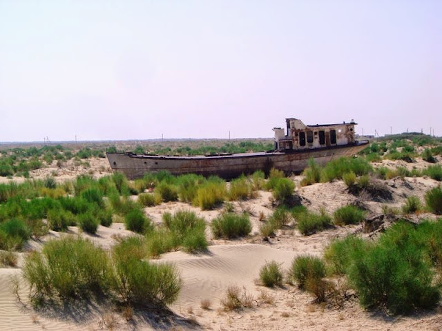
Ships Graveyard in the Desert of Moynaq, Uzbekistan


In Uzbekistan, an eerie ship graveyard filled with hauntingly beautiful shipwrecks beckons, is literally a ghost town in the middle of the desert. Moynaq ship Graveyard — Mo‘ynoq also spelled as Muynak and Moynaq, is a city in northern Karakalpakstan in western Uzbekistan. It was formerly a sea port, now home to only a few thousand residents at most. Mo‘ynoq's population has been abating precipitously since the 1980s due to the recession of the Aral Sea. Because in the last 30 years Moynaq was one of two biggest Soviet fishing harbors at the Aral Sea. As the scarce few travelers who have traversed this most barren and isolated of landscapes will tell you, it’s perhaps the last place on earth you’d expect to find a flotilla of abandoned ships. Except this isn’t a mirage you’ve reached the Graveyard Ships of Mo’ynaq, a surreal collection of rusting fishing vessels in Uzbekistan, stranded nearly 100 miles from the nearest shoreline.

The Aral Sea has been gradually declining since the 1960s, as the waters of the two rivers feeding it, the Amu Darya and Syr Darya, were aimed at irrigating agricultural areas. Actually formerly one of the four largest lakes in the world with an area of 68,000 km2 or 26,300 sq mi. Aral Sea has been steadily shrinking since in 1960s after the rivers that fed it were diverted by Soviet irrigation projects.  In 2007, it had dropped to 10% of its original size, splitting into four lakes! the North Aral Sea, the eastern and western basins of the once far larger South Aral Sea, and one smaller lake between the North and South Aral Seas. Though, in 2009, the southeastern lake had disappeared and the southwestern lake had retreated to a thin strip at the extreme west of the former southern sea.

Moreover, the maximum depth of the North Aral Sea is 42 meter or 138 ft in 2008.The lessening of the Aral Sea has been called "one of the planet's worst environmental disasters". The region's once-prosperous fishing industry has been basically destroyed, bringing unemployment and economic adversity. The Aral Sea region was also heavily polluted, with following serious public health problems. The retreat of the sea has reportedly also caused local climate change, with summers becoming hotter and drier, and winters colder and longer.In an ongoing effort in Kazakhstan to save and replenish the North Aral Sea, a dam project was completed in 2005; in 2008, the water level in this lake had risen by 12 m or 39 ft compared to 2003. Salinity has dropped, and fish are again found in sufficient numbers for some fishing to be viable.

The Aral Sea watershed covers Uzbekistan and parts of Tajikistan, Turkmenistan, Kyrgyzstan and Kazakhstan. Nowadays Mo‘ynoq's is a major tourist attractions are the armada of rusting hulks that once made up the proud fishing fleet during the Soviet era. Even a one-room museum devoted to Mo‘ynoq's heritage as a center of the fishing industry. Though, poisonous dust storms kicked up by strong winds across the dried and polluted seabed give rise to a multitude of chronic and acute illnesses between the few residents who have selected to remain, most of them ethnic Karakalpaks, and weather unmoderated by the sea now buffets the town with hotter-than-normal summers and colder-than-normal winters. Let's take a closer look and see how these ships came to be stranded in the middle of the desert.


Thursday, 13 July 2017

The Giant Barringer Meteor Crater in Arizona


The Giant Crater is formed after the fall of the meteorite crater Meteor or Barringer, is located almost 69 kilometers east of the city of Flagstaff and near the town of Winslow, in the northern Arizona desert, USA. It is also called - Meteor Crater, originated about 50,000 years ago in a fall on the Earth meteorite vesivshego 300,000 tons and flying at a speed of about 45-60 thousand km / h. According to some calculations, the explosion at the fall of the meteorite was three times more powerful than the Tunguska explosion, which can be compared with a thousand Hiroshimas. Berrenzhera crater is one of the most popular attractions of Arizona. 

In the district of Arizona crater were found fragments of nickel-iron meteorite. Few meteorites, such as the Tunguska meteorite, have left behind a crater. While Berringer Crater impeccably preserved and has a shape akin to lunar craters. It is an enormous cavity width of 1200 meters and a depth of 200 meters. Moreover local Indian tribes have long been aware of the giant crater and collected scattered around the metal fragments of the meteorite. There are plentiful legends associated with this sacred place.

The existence of the crater became known in 1891, and it was thought a volcanic crater. However, in 1902, it has been recommended meteorite, and researchers involved a mining engineer Daniel Moreau Barringer. He has spent 26 years on their life, but could not prove unequivocally meteoritic origin of the crater. Although strong evidence was found specialist comets and meteorites Eugene ShoemakerIn Arizona crater trained astronauts who had to go to the moon. The local landscape is well-thought-out to be the most akin to the moon. The locals often talk about the appearance of UFOs in these places. This is not the largest meteorite that fell to Earth.

Meteors hardly ever fall to the ground; however a few cases still recorded. In 1908 over Tunguska taiga, about 10 km from the surface of the Earth, the explosion occurred. Its sound was heard nearly 1,000 km, and the trees knocked down on an area of about 2000 square kilometers. This massive explosion could have been caused by an asteroid or comet fragment. Some scholars suggest that this meteorite caused mass death of the dinosaurs that occurred 65 million years ago. According to this theory, a huge piece of space pierced the Earth’s atmosphere and reaching the surface, leaves a crater depth of 50 km, 200 km in diameter, on the seafloor. Volcanic products and hot gases joined millions of tons of dust and rocks thrown into the air.
Thus, dust rose into the upper atmosphere and blocked the way of the life-giving solar energy, initiating impaired development of the plant and decreases the amount of food that has caused the death of several animals, including dinosaurs. Moreover, a big crater, just found off the coast of Mexico, maybe confirm this theory. Presently Arizona meteorite crater is a popular tourist destination, privately owned family Barringer. On the northern edge of the meteorite crater is a visitor center, which presents interactive exhibits, and where everyone talk about meteorites, asteroids, space, solar system and comets. We can see the 637 pound meteorite found in the area, as well as fragments of the meteorite crater found in Arizona, they can even touch it. Visitor Center, formerly known as the Museum astrogeology includes theater, gift shop and observation point overlooking the inner edge of the crater, with daily excursions. In the Antarctic, on the island of Wilkes in 1962 discovered a meteor crater 241 km and a depth of 800 m in Canada on the coast of Hudson Bay has a crater with a diameter of 443 km.