Wednesday, 24 May 2017

Odiham Castle, Hampshire, United Kingdom


The Odiham Castle is a ruined castle lies on the banks of the Basingstoke Canal, but was built long before the canal existed near Odiham in Hampshire United Kingdom.  It is also known as King John’s Castle, one of only three fortresses built by King John during his reign.  He visited this area in 1204, selected the site to build Castle here lay halfway between Windsor and Winchester. The Odiham castle built on 20 acres of land, took 7 years to complete.  The castle had a two-storey stone keep and a square moat, raised banking and palisades. Particularly, the stronghold also had a domus regis or king's house. By the end of 15th century Odiham was used only as a hunting lodge, and in 1605 it was described as a ruin. Now a day, Odiham Castle is open for public and only visible remains are part of octagonal keep and outlaying earth works. Therefore, in Sep 2007 Hampshire County Council undertook a restoration of the shell keep under guidance from English Heritage. The Odiham Castle design was certainly unusual; the great thick walls are made up almost entirely of flint, which would have been clad in dressed stone, with narrow brick arches on some of the openings.

The most southerly corner of the moat survives in the form of a small overgrown pond on the opposite side of the canal from the rest of the castle. Whilst the Castle is well laid out and has good historical information boards. The Greywell Tunnel is only a few hundred meters away with its history and famous Bat site stories. Two series of archaeological excavations have been carried out at the castle, one in 1953, and the other is somewhere 1981-1985. Archaeologists have worked on the site for many years, excavating finds to try to determine the castles history and the role it played throughout its years of service. Today there are still several chapters that remain untold but someone can gauge a reasonable picture of how this magnificent structure would have acted as a fort, home and at one point, even a prison. Hence, if you’re looking for a tranquil spot to walk the dog or a convenient stop off along the meandering Basingstoke Canal, Odiham Castle is definitely worth a wander.


The Lost Lake of Oregon, United States

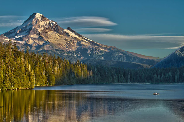
The Lost Lake is the source of a natural phenomenon that has Oregon residents stumped. When winter arrives, adjacent streams drain into the lake and cause it to fill with water. While this occurrence isn't out of the ordinary, the lake does undergo a confusing transformation in the spring. As winter comes, the lake drains like one ginormous bathtub; the hole has always been there, the shallow lake surrounded by pine trees that sits near a highway. As for its mysterious drainage, it's most likely caused by the region's spongy volcanic landscape. This particular Lost Lake is located within the Willamette National Forest just outside the Mt. Jefferson Wilderness, is one of the best known because it is easily accessible. It lies adjacent to the heavily travelled Santiam Pass Highway, Oregon Highway 20. The lake is fed by three unnamed intermittent creeks from Lost Lake Butte, and Inlet Creek from Preachers Peak.

It is believe that Lost Lake's opening is a lava tube that acts as a large drain. Unluckily, one precise question hasn't been answered. The local peoples have been speculating about where the water goes after the lake is fully drained but no one has a clue. It is believed, Lost Lake was formed about 3,000 years ago when lava flowing from the Sand Mountain Line of small volcanoes blocked a river channel to create a small basin of water which now holds the lake. The lakebed begins to fill in the late fall, when the amount of rain coming in starts exceeding the ability of the lava tubes to drain off the water, and it continues to fill all winter long in a series of rain or snowstorms. Therefore, when the rainy season peters out, the 9-foot-deep lake loses its water source, and water disappears down the lava tubes until it's gone. The lake's watery boom-and-bust cycle repeats itself every year. The lake contains brook trout, brown trout, kokanee salmon, rainbow trout, crayfish, otter, and beaver. Throughout the area are blacktail deer, squirrels, chipmunks, rabbits, black bear, cougar, and bobcat. The heavily forested area consists mostly of Douglas-fir and mountain hemlock with some cedar and white pine alder and huckleberry underbrush occurs in open areas.

However, it is not sure, where the drained lake water goes, but researchers have an idea. It likely falls down the lava tubes and seeps through layers of cracked volcanic rock as groundwater. Perhaps it may be absorbed into the porous terrain, though one thing's for sure: the hole shouldn't be plugged. If anyone was ever successful at plugging it which we're not sure they could do it would just result in the lake flooding, and the road; it's an important part of how the road was designed. More than a few small streams feed into the lake intermittently, but the lava tube drain holes are the only known outlets. The Lost Lake's water seeps into earth and refills the underground water supply that feeds springs in other areas of the forest and even offers drinking water for the community. Moreover, it is projected that the lake’s water take 7 to 10 years to filter down through all those cracks and pores before it end up in someone glass. Though, not all people are respectful of the lava tubes.

Lost Lake is classified as mesotrophic, in contrast to the large number of oligotrophic lakes in the High Cascades. The concentrations of major ions, alkalinity, conductivity and pH are somewhat above average for Cascade Lakes. The water is adequately transparent that the bottom is visible everywhere, thus this combination of characteristics indicates mesotrophic, but close to oligotrophy. The lake is also very popular to Photographers, Anything from Landscape photography to Wedding photography. It is the most photographed lake in all of Oregon, as with some of the best views for Sunrises, Sunsets, And Astro photography. The locals have been throwing trash garbage such as car parts, engines and other debris in the hole, apparently for fun or just to see if they can plug the hole. Throwing anything into the hole is strongly discouraged by forest officials as it could flood the lake and the road.


Friday, 19 May 2017

Salar de Uyuni: The Nature Best Piece on Planet Earth


The South America salt flats in Bolivia are a natural wonder that are not only awe-inspiring, but also seem to be the best place to play with perspective. With reflections that play tricks on the eye and constant bright sunshine, Salar de Uyuni is a veritable dreamland for the photographer with a sense of humor. Salar de Uyuni also called Salar de Tunupa (can be translated from Spanish as ‘salt flat enclosure’) is the world's largest salt flat at 10,582 square kilometers. Salar de Uyuni is located in the Daniel Campos Province in Potosí in southwest Bolivia, near the crest of the Andes and is at an elevation of 3,656 meters above sea level.

The Salar was formed as a result of transformations between several prehistoric lakes. It is covered by a few meters of salt crust, which has an extraordinary flatness with the average elevation variations within one meter over the entire area of the Salar. The crust serves as a source of salt and covers a pool of brine, which is exceptionally rich in lithium. It contains 50 to 70% of the world's known lithium reserves, which is in the process of being extracted. The large area, clear skies, and exceptional flatness of the surface make the Salar an ideal object for calibrating the altimeters of Earth observation satellites. The Salar serves as the major transport route across the Bolivian Altiplano and is a major breeding ground for several species of flamingos. Salar de Uyuni is also a climatological transitional zone since the towering tropical cumulus congestus and cumulonimbus incus clouds that form in the eastern part of the salt flat during the summer cannot permeate beyond its drier western edges, near the Chilean border and the Atacama Desert. The Salar de Uyuni also holds other associated records when flooded, it becomes the largest mirror in the world, and it also holds the largest land reserves of lithium.

There are a lot of places on Earth considered to be spectacular in a unique and mysterious fashion. Bolivia’s popular salt flats or Salar de Uyuni definitely qualifies. One of the most popular attractions in Salar de Uyuni is a cemetery for trains! It contains all the trains that were used in mining during the 1940s and currently attracts thousands of tourists every year. Moreover, at times the salt flat is covered in very clear water, making it the largest natural mirror in the world, an estimated 11 billion tons of salt is believed to be within Salar de Uyuni. There are 80 species of birds (visiting and migrating) at Salar de Uyuni, including three species of flamingos, as well as a few islands, where the main foliage is cacti, as well as hot springs and geysers.. It was believed that Salar de Uyuni was completely flat, but later some small undulations were discovered on the surface. NASA uses Salar de Uyuni, since it is unmoving and easily spottable, to figure the positioning of NASA’s satellite. To be honest strictly speaking not a real lake, since almost completely dried up, the Salar de Uyuni is the largest salt desert we can observe on Earth, surrounded by mountains, water evaporation, leaving behind the heavy elements and salt residues. The Salar de Uyuni simply is the largest land reserve of salt in the world, which has a surprisingly high rate of lithium, the same metallic element that we're using in our computer's lithium batteries. The salt desert actually represents by itself, one-third of the known reserves of this element.


And when it's rainy season, and the desert becomes a lake, the water salinity and the underlying layer allow the light to be perfectly reflected, so as lake turns into the largest mirror in the world. It is so flat and calm that it gives the best opportunity for the calibration of satellite, 5 times more efficient compared to a conventional waterbody (sea or another lake).


The Granite Dells of Prescott, Arizona

The Granite Dells is located outside the city of Prescott in the US state of Arizona. The Granite Dells are a exclusive geological formation comprising of colossal granite boulders that have eroded into rounded bumpy and strange shapes giving the rocks a rippled appearance. It is believed that these exclusives rocks formed 1.4 billion years ago at a depth of 2-3 km, before they were exposed by weathering. This process is known as spheroidal weathering, common in granitic terrains, the rocks assumed rounded shapes and other rare rock formations that characterize the Granite Dells.
Thus, two very picturesque artificial reservoirs “Watson Lake and Willow Lake” situated nearby the formation. The two lakes combined with abundant hiking trails offer a great place for boating, picnicking, hiking, and birding. The Granite Dells rugged beauty and dramatic rock shapes is the perfect backdrop of surrounding mountains, with acres of open space, and planned hiking trails with connection to more than 400 miles of public trails. The Dells' granite has strangely high uranium content, and thus homes built over the granite should be checked for radon leaking from the granite.


The Oriental Lion, The World’s Largest Redwood Sculpture

A huge wooden sculpture of a roaring lion now stands proudly in a Central Chinese city square, and the journey it took to get there makes it all the more remarkable. The Oriental Lion has been dubbed, carved from a single redwood tree trunk more than three years. It is established by Chinese architect Dengding Rui Yao, assisted more than 20 people.  The project was initiated in Myanmar, where the carving was seen through. Lastly, when the great beast was completed in Dec 2015, it was transported more than 3000 miles to reach the Wuhan’s Fortune Plaza Times Square. Moreover, Oriental Lion‘s head, paws, and tail have been sculpted into a smooth finish, with the torso maintaining the trunk's uneven texture. The giant 47.5 feet long, 16.5 feet high, and 13 feet wide, the Oriental Lion is a force to be reckoned with.
The Lions play an important role in traditional Chinese culture. It is seen as protectors, lion statues became a common installation at the gates of imperial palaces, including the legendary Forbidden City in Beijing. Nowadays, they can even be found outside of hotels and restaurants, just in case any evil spirits drifted from the Han dynasty into modern times. This is world's largest redwood sculpture according to Guinness World Records. It's unknown if the wood was sourced from China, it was a tree that was sick or dying rather than being chopped down for the project. If it did come from China, it's most likely a Met-asequoia, a fast growing tree found in the Hubei Province. Since its installation in Wuhan, the giant lion has become a favorite new monument in the city.