Sunday, 3 January 2016

Beehive Huts Ireland


A Clochán is a dry-stone hut with a corbelled roof, usually associated with the south-western Irish seaboard. In Irish the name clochán, is given to these structures, derived from the word “cloch”, a stone, it reflects the fact that they’re constructed wholly from stone without the use of mortar. Clochans are mainly found in the Southwest of Ireland, in the Dingle Peninsula of County Kerry. Several occur in religious contexts such as used by the monks successors carried on the architectural tradition in the Scottish Isle of Iona.

These are amazing huts built each layer of stone inward just enough to close the top with a single stone to see how the natives of Ireland lived merely a few hundred years ago. These were some hearty folk who lived in these stone enclosures tending to their sheep and potatoes. This will completely understand why so many emigrated given the chance in the 19th Century. According to archeologist the exact construction date of these structures is unidentified with any degree of conviction. No direct evidence to date any of these buildings before the 8th century. Whereas some connected with religious sites may be pre-Romanesque, considers most to date after the 12th century, including up to the 19th century.

These are usually round beehive huts and rectangular footprints date to a later era, which are not completely built of stone, and may have possessed a thatched roof. The Clochan walls are very thick, up to 1.5 meters and some times more than a few are joined together by their walls. The building technique behind the clochán is an ancient one, which employs the principle of corbelling. Therefore it is a simple but effective method of construction and has been used for many centuries, not only in Ireland but in other European countries too. In many countries such huts were built as temporary shelter for nomadic shepherds as they moved around with their flocks.Source: Charismatic Planet

Northumberlandia: The Lady of the North East England


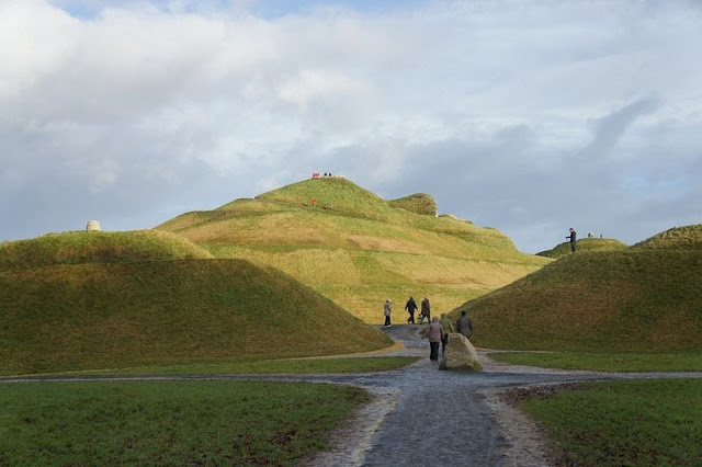
Meet the supine, the Lady of the North the former coal mining town of “Cramlington, Northumberland”, North East England, is a massive piece of land art in the shape of reclining lady named “Northumberlandia”. The lady is more than a hundred feet tall at her tallest point, her forehead, and a quarter of a mile long. The Woman lies on her back, with her long hairs spread out, upper body in supine position and her lower torso twisted towards her left, as it looks like that she is dancing. It is created by American landscape architect and designer Charles Jencks, “Northumberlandia” is said to be largest human landform sculpture in the world. It is officially opened by a woman “Princess Anne” in September 2015, it has become an apparent hit, with 25,000 visitors in its first few weeks.

Hence, “Northumberlandia” was shaped from the by-products of an opencast mine in “Shotton” well owned by Banks Group and Blagdon Estates. Whereas digging for coal the employers feels that there was a fabulous opportunity to imaginatively reuse all the rocks and dirt dug out of the ground in its place of dumping them into bland hills. Therefore, they contacted famous artist “Charles Jencks” to see what could be done and Northumberlandia was born.

However, it took Charles Jencks 2 years to build and shape her shapely figure and bodily limbs out of 1.5m tonnes of rock, clay and soil redundant from the mine. Therefore, her core is made of rocks, layered over with clay and topped with soil over which an excellent grass grows now. Moreover, some of her features are beautifully artistically highlighted with stone from the mine that is frequently used for the restoration of old buildings. Thus, the figure provides a series of resting and viewing platforms, the uppermost on the forehead, from which you can get a view of the open cast mine from where she came.


Saturday, 2 January 2016

The Wave, A Unique Sandstone Formation in Arizona


“The Wave” is a sandstone formation on the slopes of the Coyote Buttes in the Paria Canyon-Vermilion Cliffs Wilderness, located in northern portion of the U.S. state of Arizona. The Beautiful sandstone formation is famous among hikers and photographers for its colorful, undulating forms, and the rugged trackless hike required to reach it. Well, this place is among the most scenic hiking destinations in the entire Southwest, so extremely popular which makes officials use a lottery to decide who gets to walk its trails. Therefore, be aware that there are only 20 daily spots that are given through a lottery, and 10 of them online and 10 of them in person, and if you win the tickets is for the next day, not for the current one!

The Wave” consists of intersecting U-shaped troughs that have been eroded into Navajo Sandstone of Jurassic age. Further, the two major troughs, which encompass this rock formation infrequent run off eroded these troughs along joints within the Navajo Sandstone. After their formation, the drainage basin, which fed rainwater to these troughs, shrank to the point that the runoff became inadequate to contribute to the cutting of these troughs. The Wave exposes large-scale, sets of cross-bedded eolian sandstone composed of rhythmic and cyclic alternating grain-flow and wind-ripple laminae. The Wave is the result of the differential erosion of rhythmic and cyclic alternating grain-flow and wind-ripple laminae within the Navajo Sandstone. The soft sandstone, including the ridges and ribbing, of The Wave is fragile. As a result, persons must walk carefully to avoid breaking the small ridges.

The Wave and its signature landscape among the most photographed in North America, and also be called the Devil’s Playground.  Officials, described in its website as “a gallery of gruesomely twisted sandstone, resembling deformed pillars, cones, mushrooms and other odd creations with the unique blending of color twisted in the rock, creating a dramatic rainbow of pastel yellows, pinks and reds.” The arduous hiking demonstrates the inherent risks associated with hiking in southern Utah's desert country. Even though to make sure you’re extremely fit for this hike, it is highly recommended to do it early in the morning, and make sure you have enough water and supplies. Moreover, hikers must choose their own route across the open desert, which needs traversing exposed sandstone, sand dunes, and sandy wash bottoms. 

Friday, 1 January 2016

Iceland Staggering Blue Crystal Ice Cave


Well, by seeing the stunning picture of Iceland Staggering Blue Ice Cave, you must feel that this would be out of this world where no two days are ever the same. Iceland is the incredible changing landscapes of one of the world's most beautiful countries. Explorer “Helen Björnsdóttir” who is from Reykjavik,works as an ice cave expert - assessing the safety of the caves before leading tourists inside but also takes stunning photos herself. Therefore, she has exposed these photographs of the caves that never look the same two days in a row. She said, what attracts me to ice caves is how unique they’re the feeling to enter the glacier and being surrounded by the glacier ice is an incredible feeling. When I look the blue colors and ever changing forms and shape of the ice caves also astonish me. Moreover, that you enter an ice cave and you know that it will not be there next year and you have new ice caves to explore.

Further, before I moved here I had no interest in photography but when I became an ice cave guide, I just couldn't resist taking pictures. For me, it’s quite a complicated art.  Although, the ice caves are very dangerous and there’s often a lot of work to be done on the ice caves before we can take travelers near them, like chipping the thin ice away from the ceilings. Moreover, we have also had to move boulders from the glacier above the entrance to make sure they don't roll down and block us in. We’ve to do this every day just because a cave is safe one day, it doesn't mean that it will be the next day. The way the water melts can make a cave very unsafe very fast.'Source: Charismatic Planet


Hole N' The Rock, Utah


Well, different people shows their love with different way, just like some dads build their kids tree houses, but in the treeless desert of southeastern Utah, “Albert Christensen’s” only likely alternative was a cave. A badass dad that he was, Albert Christensen blasted the rocks off a sandstone cliff face near U.S. Highway 191, so that his sons could sound sleep at night. Therefore he continued drilling and getting bigger the cave for twelve years until it was big enough for both him and his wife to move in in 1952.
Thus, the 5,000 square foot subterranean house is equipped with ample 14 rooms arranged around giant pillars, a beautiful fireplace with a 65-foot tall chimney and a lovely deep bathtub built into the rock. Though, Albert Christensen was building a hundred-foot tall staircase when he died.  Moreover the stairs would have cut up to the top of the rock, where his wife would have arranged a rock garden. Therefore, after her husband’s death, Gladys continued to increase the property, opening a gift shop and giving tours of her home until she passed away in 1974. 

These days, the Christensen family house welcomes travelers along U.S. Highway 191 with vast painted white letters on the cliff face that scream "Hole N' The Rock". Furthermore, the sculpture of Franklin D. Roosevelt on the face of the rock above his home was also made by Albert. Thus, most of the original furnishings, Alberta's paintings and Gladys's doll collection, along with Albert’s taxidermy specimens two stuffed horses, donkey,  and are left untouched as a memorial. 

Likewise also displayed several of the tools used to make this home. Albert and Gladys’ graves are placed in an alcove a short walk from the entrance. In 2000 “Hole N' The Rock” was purchased by Erik and Wyndee Hansen from Gladys' son, Hub Davis. They have added a trading post, an outdoor petting zoo, a giant cactus made of bowling balls, and a two-story outhouse. Thus, when you travel at U.S. Highway 191, this is a must visit place. You’ll definite like Albert and Glady’s home.