Friday 9 August 2019

Logan Pass, Montana United States

Logan Pass is in Glacier National Park, in the United States of Montana. Logan pass elevation 6,646 ft is the highest point on the Going-to-the-Sun Road reachable by car in the park. It is a famous starting point for hiking and backpacking trips. Highline Trail is the most popular trail, which heads north along the west side of the continental divide.
Another natural trail to Hidden Lake Overlook starts behind the visitor's center.  Here, Garden Wall, famous for the proliferation of wildflowers that grow in warm weather. Clements Mountain and Reynolds Mountain tower over fields of wildflowers that carpet the ground throughout the summer.

Also, on the east side of the pass, an area recognized as Big Drift, often records over 100 feet of snowfall in winter. Logan Pass named after Major Willian R. Logan, the first superintendent of the park. One of his best contributions to the park was hiring park rangers to make more trails within the Glacier National Park. Moreover, the pass visitor center is open during the summer season on the east side. But Pass is normally closed in winter due to avalanche hazards.
The Logan Pass Sun Road open from Mid to late June until 15th October. The spectacular Mountain goats, bighorn sheep, Marmot, Pikas, and the sporadic grizzly bear unwieldy through the meadows offer remarkable wildlife viewing opportunities.
In 2014, there is 139 miles per hour wind gust was recorded at Logan Pass broke the earlier record of 133 mph in 2016. However, the average wind speed was 66 mph. The Logan Pass provides an imposing vantage point to view wildlife some of the most beautiful scenery in the world. If you want to really enjoy, then you should make an early plan or late in the day. Otherwise, parking is a big headache here.
Because rising sunlight on the mountains provides brilliant views to photographers and the chances to see wildlife. One of the most scenic stops on planet earth. One can plan to drive up there from both the east and west side of mountains, as lakes look completely different in each direction.
You can easily say that Glacier National Park is the Crown of the Continent, and Logan Pass is a most illustrious jewel. If you are looking for peace and serenity, then nothing is more romantic than setting up lawn chairs and counting the number of shooting stars that gash open Montana big sky. On the east side of the park, the Sun Road, it’s on to St. Mary’s Lake then to Many Glacier and points outside of the park-like Waterton Lakes. Source : CP


Monday 5 August 2019

Tunnel of Love, Ukraine

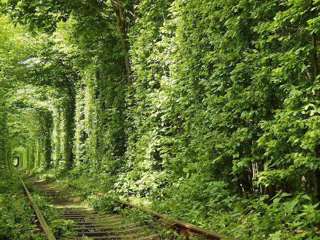
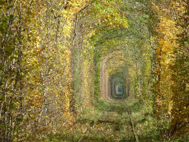
From many years, tunnel of love Ukraine, is so famous on internet. The soft-hearted loving people captivate the beauty of tunnel in a few moments. They feel themselves to be there with loved ones. No doubt, the tunnel of love is so beautiful with several aspects. Tunnel of Love Ukraine is the name given by local people to this fairytale track. The lush green tunnel seems out of natural world, captured much attention, being a perfect photography spot.
The Tunnel of Love Ukraine runs a 3 to 5 km section of industrial railway located near Klevan, which is linking it with village Orzhiv. However, on the Kovel-Rivne line, the total length is seven kilometers. The majestic railway track is surrounded by green arches, which is famous for being a beloved place for couples to stroll in the middle of path. Trees with overhanging branches were left to grow freely around the line, thus, the passing train is the only thing, which is shaping its way through.
The green corridor is an industrial track for wooden work, fiberboard factory employed three times a day, but depending on how much plywood is to transport. The line is being at Klevan station and reaches the northern area of Orzhiv. The 4.9 km line is fully covered with dense forest out of whole line of 6.4km. However, tunnel of love stretches anywhere from 3 to 4.9 km, depending on how individuals count it. The gloomy atmosphere offers a degree of privacy and scariness. It is an ideal spot for selfies, wedding photos, for FB and Instagram depends on your perspective.
The local people were quite mystified when tourists abruptly started appearing in their one-street town and tramping along the railway line. The darkness provided a degree of privacy and the terrifying scenes offered a socially acceptable excuse for the physical contact at a time when public affection or even holding hands was considered inappropriate. In the earliest personifications, riders were taken by two-passenger boats via dark passages.
There were two major themes, a relaxing romantic ride motivating the couple to hold, or a spooky horror ride inspiring the couple to cling to one another and make a wish will get what they want. Before to go there, keep in mind, the tunnel has official protection or guardian. A nearby factory cut down many trees to widen the train passage which in result of huge outcry.
From all part of Ukraine, the birch trees are trucked into the Odak factory. Then they are turned into finished plywood panels. After that they are loaded onto large containers and hauled by trains to the Klevan railway junction.  Hence, at Klevan the goods are taken along the main trunk line to markets across West Europe.
The tunnel ever growing popularity, new wedding couples prefer to make a photoshoot there. Thus, visitors are creating more problems for train operators in managing the speed and control. Although, there is no major incident took place here, but a 38-year-old lady was struck by train, fracturing her hip.
The best time to go tunnel of live is end of spring and early part of summer. In this time, the greenery looks fresh, not too dry or yellowish. However, in the autumn you can enjoy the golden autumnal colors, look gorgeous. Also, in winter the you can capture a perfect winter wonderland. In the end, you might be thinking before to go there. Is the Tunnel of Love Ukraine is live up to expectation? The short answer is off course “Yes”.


Saturday 3 August 2019

Danakil Desert – One of Hottest Place on Earth

On the planet earth, there are only few places where temperatures pass 50 °C. Ethiopian Danakil Desert is one of them, which is famous for its volcanoes and extreme heat. The 136,956 square kilometer’s desert is located on the Southern Eritrea, and northwestern Djibouti. The hottest place on earth has only an inch rainfall round the year. But the great thing of Danakil Desert is having many lakes formed by lava flows that dammed up numerous valleys.
One of Lake Afrera/Giuletti 260ft below sea level has thick saline crusts on its banks. Another Lake Asale also possess cryptodepression in the Danakil Depression. The Danakil Depression overlaps the borders of Eritrea, Djibouti and the entire Afar Region of Ethiopia. It is the hottest places on the planet earth sometimes called "the gateway to Hell”.  
Due to extreme climate, this region's look like an alien land. In fact, the region has strange geological phenomena that one can see in his entire life. The volcanoes with bubbling lava lakes, multi-coloured hydrothermal fields, and great salt pans that dazzle the eyes. 
The desert is inhabited by few peoples that is called Afar. Every morning, hundreds of men converge on a dry lakebed in a remote corner of Ethiopia, where they cleave the ground open with hand axes to extract salt, like their fathers and grandfathers once did. They are engaged with salt mining, used camels to load thirty salt bricks weighing 4 kg each. However, their bodies are well adapted to the extreme heat and dryness, hence they need far less food and water than most other people.
The guards guarding the camels from bandits until they reach the destinations. Hence, against all odds, Afar people do live here and call it their home.  The desert has various climate cycles, tectonic activity and discontinuous erosion. One of geological feature is the movement of Africa tectonic plates moved away from Asia.
The Danakil Desert unique rivers never reaches the sea, flowing from highlands down into lakes and then intense heat evaporates water leaving behind the great salt pans. But still dry and barren place brings life, both in the water itself and the valuable salt that it carries. Many mountain chains formed, layers of sandstones and limestones deposited further offshore.
As the land rose the more sandstones formed above the limestones and tectonic shifts caused lave poured out of cracks and cover the sedimentary deposits. One of Danakil Desert area is bordered with Alps, a tabular mountain system. The highest peak is Mount Ramlo almost 7,000 ft.  The Afrera contains several active volcanoes, including the most famous Erta Ale.
Why is Danakil Desert Dangerous?
The desert is extremely breathless oxygen in certain territories, as air is burnt and filled poisonous gases. Many people hesitate to go some places due to risking their lives. Keep in mind all these factors, Danakil Desert is one of the most inhospitable environments in the world.
This moon-like landscape is a harsh place to live. Numerous fossils of ancient hominins have been unearthed here, instigation some paleontologists to suggest that this area is where our species first evolved. So, it is often referred to as the "cradle of humanity".

Finally Revealed: The #1 Secret For Manifesting Wealth, Happiness, Love & Success


Thursday 1 August 2019

The Ancient Kukaniloko Birthing Stones

The sacred Kukaniloko Birthing Site is also called Kukaniloko Birthstones State Monument. This is a one of most important ancient Hawaiian cultural sites on the geographic center Island of Oahu near Wahiawa. A sort of Stonehenge lies near the intersection of Whitemore Avenue and Highway 80. The site was built in 12th century by an Oahu Chief, whose son Kapawa was the first birth here.
The site was first recognized, preserved and protected by the Daughters of Hawaii in 1925, care of Kukaniloko was passed to HCCW in 1960. Then in 1973, the group of rocks listed on the National Register of Historic Places. In 1992 the site was declared a state park and increased its boundaries to 5 acres field. The site is also known as the Galbraith parcel that was once a pineapple farm.
The Birthing Stones marked as royal births which commanding brawls for centuries and served a secret astronomical function. The site was employed as a royal birthplace for 12th through 17th centuries. In the recent times, the site encompasses 180 large stones, and some of smooth, few carved with long grooves or bowl shapes.
These birthing stones were placed in an area where the ancient islanders had the strong faith of life force of the land was very vigorous. This spot was home to several battles between tribes that would decide the fates of their entire communities.
When a new chief expected to be born, the Royal Women would have to brought to the ancient rocks. The Kahuna (priests)suggested the strict diet plan and exercises of royal women. So, lady didn’t suffer pregnancy pain during childbirth.
Then 36 to 48 chiefs (18 to 24 on each side) witness the birth would take place for the oral historical record. Therefore, when birthing process complete, the infant would be swept away, even not to be seen by mother until it had reached the maturity. After birth, sacred chanting and drumming of Hawea was beaten would announce the royal birth.
This practiced reducing the chance of murder from rival chiefs. The royal women birth assures regal status for their offspring. This was considered essential to confer royal status and maintain royal lineages.
The rocks believe to serve a main ritual purpose to the tribal Hawaiians.  The latest studies also show, that patterns on the stones that may have served an astrological purpose, acted as a sort of Pacific Island henge. The stones rows added to represent the ranks of chiefs, which come to witness the births or defend their land. However, the original rock stones still rest on the site, waiting to usher the next big Kahuna in to the world.
Further, in a 1940 Hawaiian Mythology described, that there is no proof that cannibalism was ever practiced at this site. But supposed cannibal feasts attracted peoples in 18th century, and such superstitions stories soon filled travel accounts.
The Kukaniloko means "to anchor the cry from within”. The native Hawaiians believed that this is a sacred site, so don’t climb, remove it or jump over it. Each month thousands of people visit Kukaniloko, including doctors, midwives, Native American groups, halau hula and individuals connected to spirit through hearts of aloha.
They are having strong belief that spirit does not know any language, nationality or color. It only knows heart. We all have a cry from within. Indeed, this is very fascinating bit of Hawaiian history and be respectful, learn the history before going and continue your learning of Oahu after. One can see the stones from the street and it’s a short walk to see them. This site for sure a peaceful and magical experience and sacred cultural sight. The rock stones and grove of trees tells their story. 


Source: CP


Monday 29 July 2019

Mahodand Lake, Swat Kalam, KPK, Pakistan

If you are undecided where to go in Pakistan? Then we suggest you get your luggage ready and take the route to Kalam. The ultimate abundance of unimaginable natural beauty is awaiting you. The high rises peak feast your eyes wide open to see the small streams and waterfalls along with Swat River running between dense forest.
Then park your car at Kalam valley and hire a private jeep to route your way to Mahodand Lake. Make sure, you must get ready 7:00am sharp as you have to cover approximately six destination on the way to Lake. You can spend half an hour at every place to feel the real beauty of Kalam valley. These points are Ushu Forest, Mahi Banal, Matiltan, Shaudur Waterfall, Chasma-e-Shifa, Mahodand Lake and Saifullah Lake. Ask your driver to drive jeep carefully, as this is the mountain road with hairpin curves, dangerous drop-offs and pretty narrow.

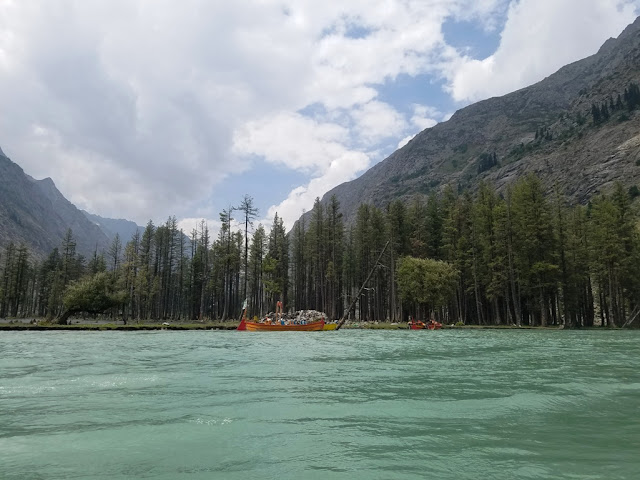
The gorgeous crystal-clear lake is about 40 KM from Kalam in the Ushu Valley of the Swat District, KPK, (Khyber-Pakhtunkhwa) at an elevation of 9,400 feet. Mahodand lake banks are beautifully covered by high rise pines and pastures that serve as a camping site during the summer. The Lake is fed by melting glaciers and springs of the Hindu Kush mountain and gives rise to Ushu forest the major left tributary of the Swat River. Mahodand Lake is famous as “Lake of Fishes”.
Brown and rainbow trout fish is commonly found in the lake. The emerald green color water is divided into a series of small and large streams.  The locals are doing over-fishing for daily income, which is badly hurting the fish population. They also use illegal fishing methods like electrocution, dynamiting, and large nets. Mahodand lake is mainly reachable in summer season, however access is limited in winter. The lake is mainly covered with thick snow which caused high risk of avalanches.
Mahodand Lake basin is surrounded by a sheet of alpine flowers like geum, blue poppy, potentilla and gentian. Many stunning waterfalls reinforce the sweetness of the vale with different lengths and sizes. When crystal clear water comes down, you will feel like a milk coming down from rock mountains with cracking sound. The weather is quite pleasant in summer, so it is better to have some warm clothes for your children for any emergency. The temperature is cold if there is rain.
Hence, the gravel and tricky bumpy road in not paved, but surrounding are truly amazing. Visitors are facilitating in tent to enjoy the lush green valley. Each view is unique of emerald green field along the lake. People enjoy here boating, camping, horse riding, birdwatching, relaxing, nature, and many more. Also, you must take your power bank, to charge your phone battery. At every point, you would like to take snaps or selfies. So, phone charging is very essential to be full before your journey starts. Indeed, Mahodand Lake is a gift of nature who loves nature. The majestic landscape covers high rise cedar trees, exotic flowers, herbs, and roaring river swat.
Read More – Ansoo Lake – The Shape Resembles to Teardrop of Human Eye