Saturday, 11 October 2014

The Lava Tree State Park Hawaii United States


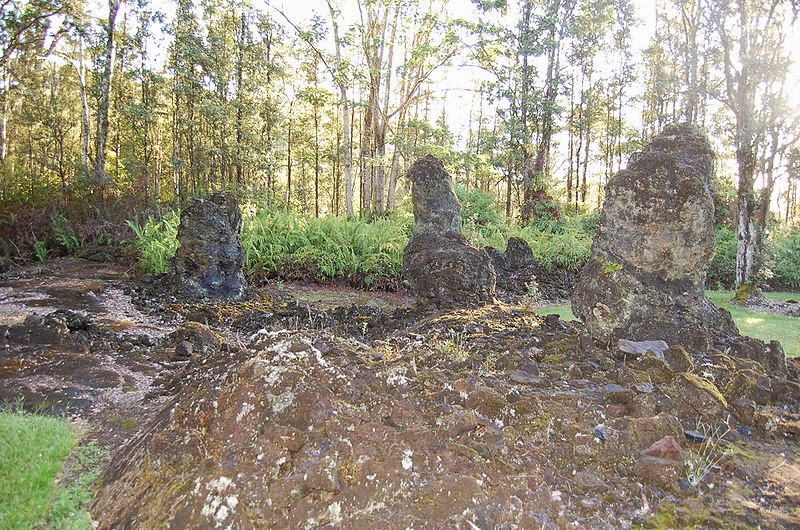
The Lava Trees in Lava Tree State Park were created in a 1790 lava flow, which entered the area and buried the 'Ōhi'a Trees up to 11 feet deep in molten lava. The Lava Tree State Park sits within the Nanawale Forest Reserve in the lower Puna district near the town of Pāhoa. Although lava trees can be found in several locations on the Big Island this particular park have a number of exceptional examples as well as being very accessible.
When the hot lava from a volcanic eruption enters in a forest, often it is observed that the lava does not overthrow the bigger trees, but flows around them. Normally the moisture in the tree make cools the lava in contact with the trunk and a hard exterior shell is molded. So as the lava drains away, only the solidified “lava trees” are left standing. The intense heat burns away the wood inside and a hollow cast in the shape of the original tree is left behind. In particular cases, the tree can keep on standing and stays for years as a black charred skeleton, and in sporadic cases, specific trees even survive and continue to grow after the eruption. The finest example of lava trees are originate on the island of Hawaii, in southeast of Pāhoa in the Puna District.
Here, the whole forest of ohi’a trees was swamped in molten lava up to 11 feet deep, when the Kilauea volcano erupted in 1790. The higher trees that were surrounded by the molten lava cooled the lava that coated them, though the heat of the lava began the tree to burn to ash. Therefore since then a close fissure opened in the ground letting the molten lava to drain away back into the earth. Nonetheless the lava surrounding the trees had already cooled and in progress to harden and remained above ground as monuments to the trees that once stood in the same spot. The forest of lava trees causing from eruption of a one kilometer line of vents east of Pu‘u Kahaualea. The bulbous top of each lava tree marks the high stand of the lava flow as it spread through the trees. As the fissure eruption diminished, the flow constant to spread laterally; its shallow subsided, leaving pillars of lava that had chilled against tree trunks.
Then spattering is from fissure out of view to the left. Note blob of spatter following to the top of the stripped ‘ohi‘a tree. Nowadays, the Lava Tree State Park contains of 17.1 acres of native plants, trees and several lava trees. Several of the lava trees are well covered in moss, though others have fallen to the ground, revealing their interior hollow structure. Specific of the casts are so impeccable that you can still realize the imprint of the bark in the lava rock itself.
The Lava Tree State Park is in the lower Puna district, and to get to the park you need to take Highway 130 towards the town of Pāhoa, then pass the first intersection that takes you into Pāhoa and at the next intersection make a left onto Pāhoa-Kapoho Road. Follow this road for just three miles until you see the park on your left. The park has a paved parking lot and restrooms nearby from the parking lot. Moreover there is no drinking water available in the park. The trail around the park is paved but is jagged and broken in places due to tree roots. The trail is not navigable through its full length by wheelchair. The Lava Tree State Park is at around 500 feet above sea level. The climate conditions are wet though warm. Shorts and rubber slippers or shoes are suitable. You might want to have light rain gear in the car in cast it decides to rain. The park is open 24 hours a day, year round. There is no cost to visit the park.

Friday, 10 October 2014

Exotic Fulmer Falls in Pennsylvania


Fulmer Falls is the second waterfall located in the George W. Childs Recreation Site in Dingmans Ferry, Pike County, Pennsylvania, United States of America. The falls are downstream from Factory Falls and upstream from Deer Leap Falls on the Dingmans Creek. At 56 feet, it is the largest of the three falls. It is believed that Fulmer Falls might be the tallest of the three falls, although Factory Falls might also be around the same size. None of them are huge, but they’re all beautiful and very easy to visit. In order to have better view of Fulmer Falls at its best, you do have to leave the wooden boardwalk, though it’s not hard to do. You just have to slip under to get that better view. The Fulmer falls can be reached at 41°14′12.36″N 74°54′55.62″W from Childs Park Road, west of Lake Road (State Route 2004), 2.6 KM north of Pennsylvania Route 739. There’re picnic tables set throughout the recreation area ad restroom facilities are also available here. The nearest major town is Dingmans Ferry, PA. Fulmer Falls is a magnificent waterfall to photograph. You can picture the entire falls, but it is also very easy to satisfy your hobby by taking unlimited photographs.

Mount John Laurie Canada


Mount John Laurie is a mountain in the Canadian Rockies, officially named in 1961 and famous as Mount Laurie, or by the Nakoda name name Yamnuska (unofficial name), or simply Yamnuska which means (wall of stone), and it is located in the province of Alberta, Canada. The word Yamnuska" is perceived from the Stoney Nakoda word "Iyamnathka" that describes steep cliffs or "the flat faced mountain." Actually John John Lee Laurie, (1899-1959), was an educator and political activist and a founder of the Indian Association of Alberta.

The Mount Laurie is the most easterly mountain in the valley and features very steep, often vertical and overhanging south cliff 360 metres in height and almost two KM in width. The mountain's 1961 renaming came at the request of the Stoney Nakoda First Nation. Laurie, an educator and political activist, served as secretary of the Indian Association of Alberta from (1944-1956), encouraging the causes of Alberta native peoples. Mount Laurie is standing at about 2,240 meters above sea level, and is the first mountain on the north side of the Bow River valley (Bow Valley) as it exits the mountains for the foothills and prairie of Alberta. It is well situated close to Calgary; and it is a widespread "Great Scramble". It is also very famous for rock climbing destination, with more than hundreds routes of all difficulty levels spread out across its face.

Mount John Laurie is the result of the McConnell Thrust Mistake, which put the resistive, cliff forming Cambrian carbonate rock of the Eldon Formation on top of the much younger and weaker Cretaceous aged, clastic Belly River Formation. The error, which sits at the base of the cliff face, represents an age variance of around 450 million years. The access is to mount Laurie is at the Highway 1X and Highway 1A (Bow Valley Trail) intersection, travel east for two kilometers. Turn into the signed parking lot that says "Yamnuska”.


10 other mountain peaks closest to Mount John Laurie:

1.                Mount Yamnuska (2240 meters)                                    0.0 km
2.                Mount Fable (2702 meters)                                             7.6 km
3.                Heart Mountain (2135 meters)                                       9.2 km
4.                Grotto Mountain (2706 meters)                                     11.4 km
5.                Mount Sparrowhawk (3121 meters)                              11.5 km
6.                Mount Lady MacDonald (2605 meters)                       14.0 km
7.                Mount Baldy (2192 meters)                                             15.0 km
8.                Squaw's Tit (2514 meters)                                                15.4 km
9.                Mount Charles Stewart (2809 meters)                           15.5 km
10.              Middle Sister (2769 meters)                                             17.2 km