Wednesday 2 March 2016

The Spiral Jetty, Utah


The Spiral Jetty actually a monumental earthwork was created by artist Robert Smithson in April 1970. Smithson documented the construction of the sculpture in a color film named “Spiral Jetty”.  It is located 
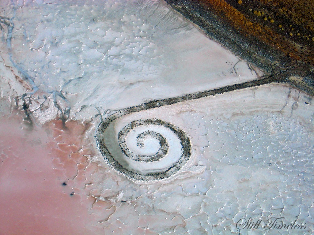
off Rozel Point in the north arm of Great Salt Lake Utah entirely of mud, salt crystals, black basalt rocks and water. Spiral Jetty is 460 m long, 4.6 m wide coil that stretches over 1500 feet into the lake. Although, you may consider as symbolize of large-scale earthwork of land art. Unquestionably the spiral Jetty is an exceptional art historical reputation and its exclusive exquisiteness have drawn visitors and media attention from throughout Utah and around the 
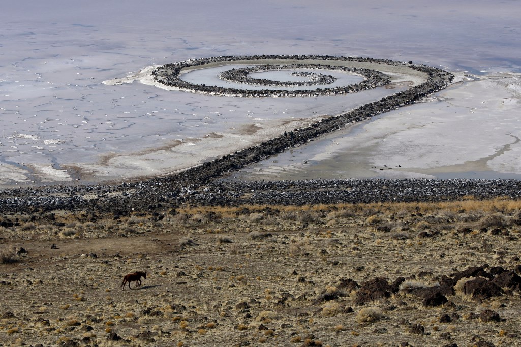
world. In the normal precipitation, water level stays a level, but varies with precipitation in the mountains surrounding the area, exposing the jetty in times of drought and submerging.

Therefore, spiral jetty is sometimes visible and sometimes submerged depending upon the water level. Moreover due to consistent ruddy water and salt encrustation, the black basalt rock emerges in large white rock. Moreover, during the construction of the jetty, Robert Smithson & his wife wrote and directed a 32-minute color film, Spiral Jetty and funded by Virginia Dwan and Douglas Christmas. In the movie, Smithson recorded his voice displaying natural history museum, prehistoric relics, construction process, earth history and his interest in geology, astronomy, paleontology, mythology and cinema.
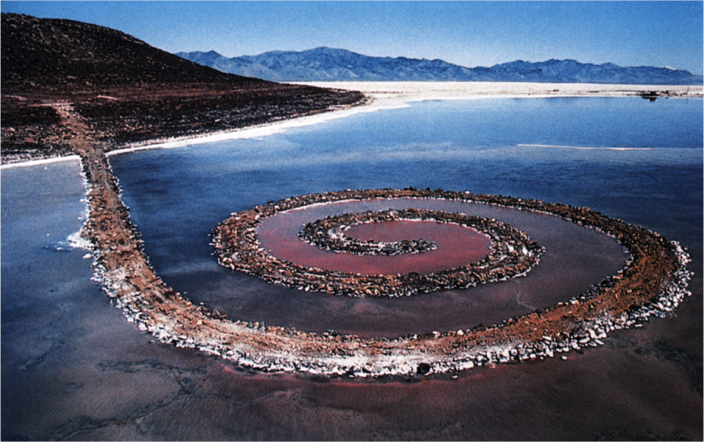
Robert Smithson selected the Rozel Point site, due to red blood color water and connection with primordial sea and stark anti-pastoral beauty and industrial leftovers from adjacent Golden Spike National Historic Site, as well as an old pier and a few unused oil rigs. The thriving Salt-tolerant bacteria and algae make the red hue water, although isolated from fresh water. The construction company 
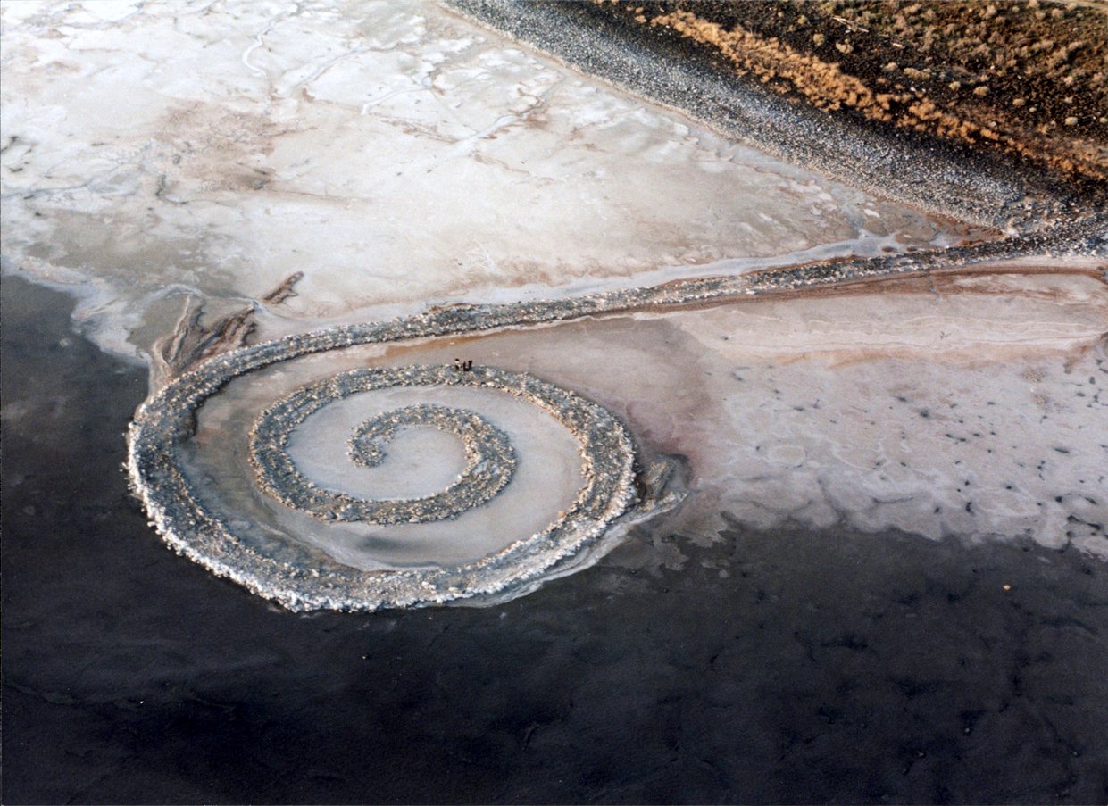
moves the rock into lake by a large tractor and a front end loader to haul the 6,650 tons of rock and earth into the lake. However, Smithson initially faces difficulties to motivate the contractor to accept this strange proposal along with land rights and earthmoving equipment. The construction took six days when the lake water was unusually low due to drought. So when the water level comes back make the spiral jetty invisible. In 2002, the area experience another drought revealing the spiral jetty second time. This time spiral jetty remained visible almost a year due to lowering the water level. The similar scenario happened in the year of 2005, 2010 and 2011. As off 2015, spiral jetty is above water and complete visible.

However, Smithson died in a plane crash in Texas three years after finishing the spiral jetty and has led to a controversy over the preservation of the sculpture. The Utah state has owned the sculpture in 2011 due to exposure and growing number of visitors. Though, it is expected that jetty will again disappear once the drought is over. So, spiral jetty surfaced many times between 1970 and 2015 due to lake-level fluctuations and survived robust wave erosion; the hard salt crust maybe cemented the boulders together and provided a protective layer on the jetty surface. Source: Charismatic Planet


Tuesday 1 March 2016

Snake Island: That You’ll Never Visit

Snake Island is also known as “Ilha da Queimada Grande”, is a small island located 18 nautical miles off the coast of the state of São Paulo, Brazil. The moderate climate island has several types of terrain, ranging from bare rock to rainforest. The Snake Island area is 110 acres and elevation is almost 676 feet above sea level. The island has variety of vegetation, partly covered in rainforest and partly bare rock and greasy cleared areas. The tiny island has been isolated from the mainland of South America about 100,000 years ago.  In fact across rough seas, it is extremely difficult and dangerous place to visit.

Moreover, the word “Queimada” means to slash and burn because when locals attempted to clear land for a banana plantation on the island, they had to clear rainforest using this technique.  Queimada Grande is home to hundreds of thousands of golden lanceheads, normally grows to be about two to four feet long is poisonous, extremely very, very poisonous. An automated lighthouse was built in 1909 in order to ships steer away from island. Due to excess number of snakes and toxicity of their venom, the Island was closed for public in order to safe people life by Brazilian Navy. Only researchers are allowed to enter the island to get research data. The scariest chemical analysis of golden lancehead venom advises that the snake is much more hazardous than its continental cousins: “golden lancehead viper” venom is faster acting and more powerful maybe five times more powerful.

The golden lancehead (Bothrops insularis) is the species of snake which gives the island its unofficial name, is the only home of the critically endangered, venomous golden lancehead pit viper, which has a diet of birds. When the sea level rise, the snakes becomes trapped at the mainland covered up the land, result in drop the population to about 2100. However, last year (2015) an estimate by a herpetologist on Discovery Channel documentary states that the population falls in 2000 to 4000 golden lanceheads. Hence, low population of Golden Lancehead list in label of critically endangered on the IUCN Red list of Threatened Species, and also in the list of Brazilian endangered animals. Moreover “Bothrops insularis” is also at risk from inbreeding, effects of which are evident in the population. Hence, it is estimated that island live between 1 to 5 snakes per square meter, is also home to many migratory birds use as a resting point.

A biologist Marcelo Duarte, has visited the Snake Island more than 20 times, says that the local negate the fact of one to five snakes per square meter, a clearly exaggeration at least not by us. It is easily observe one snake per square meter is more like it. Therefore, you’re never more than three feet away from death. According to different stories, this is perhaps the land of long buried pirate treasure, or even aliens island. The only prominent feature of Snake Island may be the perfect place for an anti-cancer drug, or anti-aging medicines. Moreover there are blue locusts and a lot of these weird, prehistoric-looking cockroaches on the ground at night that it crunches when walk. This is extremely scariest place in the world and no one is recommended don’t ever go. 

The Amazing Staircase of King of Aragon


Well, the stunning staircase of The King of Aragon is a stony staircase carved into the vertical side of a limestone cliff in the commune of Bonifacio, in Corsica, France. In French it is called Escalier du Roi d’Aragon actually cuts across the face of the cliff at a near 45° angle and is encompassed of 187 steps. However, from the side of the sea, it looks like a dark slanted line, and from near it appears as a tube scooped out of stone. The staircase was dug by the troops of the King of Aragon Alfonso V in the course of a single night during the ineffective siege of Bonifacio in 1420. Although in reality, the staircase descends to a natural spring and a cave located at the bottom of the stairway, and is thought to have been dug by the Franciscan monks long before the troops of Alfonso V set their feet on Bonifacio. 

Moreover, some legends say the first steps were carved in Neolithic times, and it has been continually improved since. These days you can walk down the steps, stroll along the sea and hike back up again. The perplexing photograph while looking up the Stairway carved into a steep cliff face in Bonifacio, Corsica, France. Upon looking carefully half a dozen times and you’ll get confused as to which way is up or down. It is suggested to must visit the staircase, probably early in the day, as you may too tired at the end of day. Therefore, you’ll feel at every step the sound of the sea is nice and increased therapeutically forget stress.

Sunday 28 February 2016

The Mysterious Boiling River of Mayantuyacu, Peru

From many centuries Peruvian inhabitants are talking about mysterious boiling river in the Amazon that burns so hot. Even some one can kill in this boiling water. The river flowing deep in the Amazon rainforest, in Mayantuyacu, Peru call it “Shanay-timpishka” translates to “boiled with the heat of the sun.” The locals folks have strong belief that boiling water is releasing by a giant serpent (Yacumama) “Mother of waters” a large serpent head shaped boulder at the river’s headwaters. The boiling river is 6 meter deep and 25 meters wide but only 6.4km long. The water temperature varies from 50 to 90 degree centigrade, and a little portion is touching 100 degree, which is hot enough to cause third degree burns within a seconds. 

Therefore, ill-fated animals have fallen into the river and got killed. Every year, a lot of tourists visit Mayantuyacu to experience the traditional medicinal practices of the Ashaninka people. Many believe, this natural wonder has managed to elude widespread notice for more than 75 years. However, Geologists dismissed the point, and argued that it’d have been take a massive amount of geothermal heat to boil even a small section of river, as the Amazon basin lies only 400 miles from the nearest active volcano. According to Spanish conquistadors were mistakenly ventured into the rainforest in search of gold. They say, man eating snakes and a river that boiled from below. 

Andres Ruzo, a geological scientist is so curious since his childhood. The Peruvian legend has the myth and had fascinated, whether the river could actually be real or not? His unanimous opinion gives the answer “NO”, the boiling river actually associated with hot volcanoes of country. Therefore, in 2011 Ruzo has decided to start his journey to see the boiling river, and he took the chance and hiked into the Amazon rainforest with his aunt, and finally saw the notorious river with his own eyes. Hence, much to his disbelief, the river was steam hot. He took the thermometer to measure the temperature, which was 86 degrees Celsius. The water was not quite boiling but really close enough to boiling. Furthermore, the river was 700km from the closest volcanic system, and temperature didn’t make any sense. 

In fact the river was only such type anywhere in the world. Ruzo, spent 5 years in investigation the river, their surrounding ecosystem, its water in the lab, in order to figure out what’s actually make him boil? Therefore, his dedication, passion and curiosity finally revealing some of its secrets, when it turns out, it are not the Sun that boils the water, but fault fed hot springs. He say, imagine earth like a human body, with fault lines and cracks running through it like arteries. These 'Earth arteries' are filled with hot water, and when they come to the surface, we see geothermal manifestations - like the boiling river.

Moreover, chemical analysis has disclosed that the water in the river originally fell as rain. Therefore, Ruzo now assumes that this happens far upstream - maybe as far away as in the Andes - and along its journey seeps down into the ground, where it's heated up by Earth's geothermal energy. It eventually emerges in the Amazon, at the boiling river. The system is part of a massive hydrothermal system, the likes of which haven't been seen anywhere else on the planet. He has also discovered some new species that are able to survive in the boiling water. 

The animals can no longer swim, and water fills their mouths and lungs, causing them to be cooked from the inside out. However, people do actually swim in the river, but only after heavy rainfalls when it's diluted with cold water. More often, the water is used to make tea and for cooking. So, he strongly believes the river is a natural wonder, and he released a book name “The Boiling River on his Adventure”. 

Friday 26 February 2016

S.P. Crater, San Francisco


S P Crater is a classics cinder cone volcano fields in the desert of San Francisco, about 40 km between Flagstaff, Arizona and the Grand Canyon. SP Crater is about 800 feet from its base, being a cinder cone; and steep and scree-covered, making the ascent a bit more difficult. Although it is surrounded by many other cinder cones perhaps much older and eroded as well. Maybe the best part of this cone is the view that can be seen from the top of the Grand Canyon and more fabulously, the San Francisco Peaks. It is thought, it is more than 71,000 years old and last eruption was recorded one thousand years ago. Moreover, leading away from the cinder cone on its north side is a large black lava flow approximately four miles long that looks imposing from the rim of the crater. However, the initials S.P. stand for “Shit Pot” a much suitable name peer into the deep crate or even venture in a little bit if you’re feeling wild.  Furthermore, the best second part is the quick “Skiing” descent that has the descender taking giant leaps in the sandy scree, a sliding way occasionally tumbling until 30 to 45 minutes to climb to the top.

SP Crater structure is made up of volcanic fragments, often glassy rocks encompassing bubbles of trapped gas.  However, when lava erupts from these structures, it frequently flows out of breaches on the side, and that appears to be the case at SP Crater. As per U.S, Geological Survey, over 600 volcanoes has been occurred the San Francisco Volcanic field. Moreover it is a striking feature when viewed from certain angles on the ground, the combination of the smooth round shape of the cone, the dark lava spatter on the rim, and the long dark lava flow extruding from the base do truly resemble a toilet catastrophe. The researchers consider the lava flow to have slightly predated the cinder cone because of geochemical data that suggests the flow is more silica rich than the cinders and based on the observation that the cone overlaps the lava flow and shows no sign of deformation.