Showing posts with label USA. Show all posts

Tuesday 31 July 2018

The Doomsday Bunkers of South Dakota


No one can sense unforeseeable future. The nuclear war or biological warfare destroyed human being. The catastrophic war can killed most living beings and wipe out earth with radioactive fallout. Hence, in South Dakota, about 8 miles south of the town of Edgemont United States plan to save a small population of 5000 human beings in a remote underground shelter would be one of the few surviving pockets of civilization scattered throughout America. These Doomsday Bunkers are equipped with protection against everything from bombs to bio-hazards. The company's latest offering, the XPoint, is advertised as the largest 'prepper' community on Earth.

The plan is proposed by California based survival company Vivos. Few years back the company acquired 18 square miles complex called Black Hills Ordance Depot. Which is completely retrofitted with full amenities like an internal power generation system, deep water wells, biological, chemical and radiation air filtration systems, sewage discharge, and critical support equipment?

The Doomsday Bunker Design contains over five hundred nuclear-hardened concrete military bunkers, to some extent buried underground and protected by thick berms of earth, to resist a surface blast wave, as well as radioactive fallout. This area is strategically and centrally located in one of the safest areas of North America, at a high and dry altitude of 3,800+/- feet, well inland from all large bodies of water, and 100+/- miles from the nearest known military nuclear targets,” Vivos says on their website. Instead of windows, LEDs are placed inside the bunkers to simulate the different views of the outside world.

Therefore, every bunker is accomplished of withstanding a 500,000-pound internal blast. Each bunker is 26ft wide and 80ft long and can accommodate 10 to 20 people and the needed supplies for a year or more. The bunkers are separated from each other by an average of 400 feet in all directions that will work in their favor by providing security, protection and privacy. The Black Hills Ordnance Depot (BHOD) was constructed in 1942 and originally functioned as munitions storage facility during the Second World War and the Cold War period.

The survival bunkers were called Igloos because of their characteristic shape. The complex was once spread over 33 square miles and contained over 800 igloos and all the amenities of a well-planned town including living quarters for over 1,000 people, an Army hospital, a post office, church, shopping center, movie theater, including a theater, swimming pool, bowling alley and other mainstays of a small American town.

The survival bunkers igloos held all types of ammunition including chemical weapons and the deadly sarin and mustard gas. The history of World War II reveals, the site also held Italian prisoners of war. After the serving its object, the facility was closed in 1967. These bunkers were used by the Army in 1942 and built with reinforced concrete to withstand a 500,000-ton blast. Peoples can now lease the bunkers to be used as shelters in the wake of a disastrous event.
In case of any nuclear war, a viral pandemic or an asteroid strike at one-time upfront payment of $25,000 per bunker, plus a 99-year lease of $1,000 per year. Moreover, shared bunkers are also available at $7,500 per person. Aside from the facility at South Dakota, Vivos also has shelters in the state of Indiana in a Cold War era bunker adept of accommodating about eighty people. Moreover, Vivos is also building a luxury private shelter in an underground complex in Rothenstein, Germany. Source: Charismatic Planet


Sliding Glass Rock, A Refreshing Area For Sliding Lovers


In North Carolina, near Brevard a sliding rock waterfall attracted thousands of visitors to take a slide all the way down the waterfall into plunge pool. Sliding Rock is a small slide type waterfall on looking glass creek. Sliding Glass Rock has a gentle slope of 60 ft long ending in an 8’ big deep pool at the bottom. On average, 11,000 gallons of water per minute power this natural wonder. People and families have been coming to Sliding Rock NC for some summertime water fun in the Blue Ridge Mountains. 

Sliding Glass Rock is one of most visited place in Pisgah National Forest. The crystal clear water is very cold but refreshing and popular for cooling off in the summer. The Sliding Glass Rock has long been used as a natural water slide for adventurous lovers. The two fun viewing platforms steps down to the pool and railing to support climb the rocks on the left side before sliding down. Tourists are allowed to take sliding down in a sitting position only. This is a heavily used recreation area which often fills to capacity. The best time to come in early in order to avoid rush which take place 12noon till 4pm.

No floatation devices like tubes, floaties or noodles are allowed. Only life jackets are permitted. The Sliding Glass Rock recreation area may close due to heavy rainfall, lighting is detected, and higher water levels. The area has been developed by the United States Forest Service into a famous recreation area. Moreover, parking is well available in a large lot above the rock and beside U.S. Highway 276. A restroom and changing room facility is available and a lifeguard is periodically on duty especially during summer weekends. You can slide during offseason times, but the water is colder than usual and there are no lifeguards or staff on duty.
In case if you are afraid of sliding down then there are a number of observation areas and decks with benches and seats, where you can relax and watch people sliding.  Because watching the children and people having a nice time to a great way to relax. If Sliding Rock is too busy, then it is recommended to take a quick drive over to Looking Glass Falls, which has a large swimmable basin at the bottom. Source: Charismatic Planet


Monday 25 June 2018

Santa Elena Canyon, The Most Dramatic Place in U.S.

The lovely Santa Elena Canyon is most inspiring natural feature in Big Bend National Park. It is visible for more than 10 miles away cutting through the mountains via a deep narrow gorge. Santa Elan Canyon is quite a long distance 30 miles however a short nature trail enters its shady depths, eight miles west of Castolon, accessible by either Ross Maxwell Scenic Drive or the Old Maverick Road. Some are really quite winding and steep.

Santa Elena Canyon downstream is most popular area for one to three day trip, easily accessed by car. It is often considered most dramatic place has the tallest cliffs forming the canyon wall up to 1500 feet. The nature trail crosses Terlingua Creek, climbs several flights of ramps and stairs and then descends into the canyon along the Rio Grande offers one of the few remaining true wilderness river trips in the United States. Side canyons create interesting vistas, as well as exploration opportunities.

Moreover the area has an extremely dry and hot climate conditions, with temperatures up to 50 °C in summer with little rain. Further, there is a contrast between the desert and cold temperate ecosystems. You should keep in mind that during the rainy season, Terlingua Creek can flood and make access extremely difficult, so it is a nice idea to prior check with Park Rangers for current conditions. Local outfitters offer various trips when conditions allow, and river runners of intermediate or better skill level often go on their own.

Hence, water flow is normally adequate for river trips except during periods of prolonged drought. In addition, beware of flash floods that can raise the river level and flow rates very rapidly after rainfall in the drainage basin, even if it does not rain at the river. The low levels of water can prevent you from rafting along the canyon which is very popular activity here. Even a short distance is worthwhile the canyon feels much more remote and undisturbed once around the first bend when the entrance is out of view. Also stargazing is relaxing activity here as on the clearest nights, around 2,000 stars are visible to the naked eye. It is an outstanding place in North America for star gazing.

Santa Elena Canyon is majestic, towering canyon walls are much taller than in Colorado Canyon upriver a few miles. The scenery is remarkable, and there are numerous opportunities for wildlife viewing, hiking in shady side canyons and camping on spacious sandbars. The best way to see the canyon is by raft or canoe. Another scenic, little visited location is Fern Canyon 18 miles below Lajitas, a narrow tributary just two miles from Santa Elena Canyon. This is very narrow and has a pretty white limestone floor, polished smooth by the waters that sometimes flood down the ravine.

It is truly a majestic and gorgeous place to spend a few days. Due to the inaccessibility of the area it is generally best to be well prepared for any and all weather possibilities. The drive up to Santa Elena canyon absolutely breathtaking and it is amazing and once you park and start walking towards the canyon, your jaw just drops at the sheer majesty of it. Definitely a Big Bend must see/do hike. It is most photographed part of the Bing Bend National park. There is a massive boulder on the trail the size of a small house that is nice to sit under on a hot day. The rock formations rising on each side of the Rio are mesmerizing.

It is highly suggest visiting the canyon in early November through mid-March. Which is generally the best time to paddle the Rio Grande? The area may be very crowded during holiday periods or during the winter "snowbird" season, which is also the time most likely to have favorable paddling conditions. Summertime low-water conditions may be inadequate for rafting, but canoes can almost always navigate the river. Moreover entrance permits to Big Bend National Park are required for all vehicles entering the park for river access.

Also riverside camping is available just outside the canyon on the left side of river and right side of Mexican.  Where ankle-deep Bermuda grass is covers the ground, making for a softer night's sleep. Firewood is scarce, if available at all, so carry what you need. Except for campfires, it is generally best to rely upon propane, butane or liquid fuel fires for cooking, personal hygiene and other general heating and cooking needs. Please keep in mind a fine may be imposed for camping in unauthorized areas.

Santa Elena Canyon location is in the middle of the continent and along a migration route, is ideal for bird diversity throughout the year. Northern species migrate here for the warm winter climate, while birds from the tropics range this far north to breed in the spring. One of major highlight is the Colima warbler, is a predominately Mexican species that only nests in the United States in the Chisos Mountains from April to September.


Santa Elena Canyon River Trip is more complicated in the last seven miles while entering the actual canyon. You can enjoy by paddling upstream from the Santa Elena Canyon Trailhead, just a few miles into the canyon, and then come back drown stream. There are a couple of rapids to watch out for, and the famed Rockslide can provide a challenge for even for experienced professionals. Santa Elena Canyon offers dazzling coves and remarkable side canyons that are a veritable feast for your eyes and your camera. So be sure to carry plenty of extra batteries. You may not want to leave Santa Elena Canyon.


Tuesday 12 June 2018

Coconino Lava River Cave, Arizona

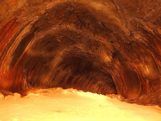
The Coconino Lava River Cave in the Coconino National Forest, near Flagstaff, Arizona is huge big enough for an individual to walk through with dozens of feet overhead. Coconino’s Lava River Cave is striking, telltale circumference of a lave tube which is more than mile long through solid rocks. Therefore, potholers won’t find stalactites or stalagmites beautifying this hall of echoes just the even arch formed by liquid-hot rock as it traveled through. The cave can range in height from 30 feet and no light sources inside.

The all of a sudden smooth surface area can actually be dangerous, due to difference in temperature between the cool subterranean cave and the hot desert above ground, condensation frequently forms and makes the walls and floors of the Lava River Cave very slick. Coconino’s Lava River Cave isn’t the only lava river cave in the world, nor is it the largest even though it fascinating visitors and geologists alike a unique (Y-intersection) deep within the tunnel. Here is two enormous tubes combines into one, forming an exclusive Y-shape out of three indistinguishable tubes. So, this leads to a dizzying mirror effect that can occasionally be disorienting to inexpert explorers.

The Coconino’s lave river cave was unearthed in 1915 by some lumbermen and named it “Government Cave”. The cave was historically been referred to as “Government Cave” due to its location on the eastern edge of Government Prairie and southeast of Government Peak. Lava River Cave is freely accessible to the general public. Many peoples in the area still call its historic name. The cave is very close to the surface above ground, with holes punctuating the ceiling at times, creating a surface treacherous for walking, but providing beautiful pillars of light from outside while traveling within it. This makes the Lava River Cave one of the most striking subterranean sites in the western United States.

It is believed that cave was formed sometime between 600,000 to 700,000 years ago. The molten lava erupted from a volcanic vent in adjacent Hart Prairie. Therefore, the top sides and bottom of the flow cooled and solidified. Whereas lava in the middle flowed out, leaving a hollow space to form the cave. Of all these intriguing curiosities, most interesting for adventurers is surely the lava tube long, cave like passages underground, arching in a near-perfect circle so ideal for traveling through, one might think they were man-made. These caves were formed millennia ago as the outside of a giant lava flow hardened, but a still-liquid center traveled through it like an underground river. Until the river stopped, leaving behind a circular tube unlike any other naturally-formed subterranean cave.

Thus due to the temperature change, there is a lot of condensation on the walls, ceiling and floor near the entrance, which makes it slippery. The temperatures inside cave are around 40 °F during the summer, and it is not rare for some of the rocks to be covered with ice. The cave is mostly dry so, bring water and at least two to three sources of light, wear warm clothes and sturdy hiking boots with ankle support and protection. Please keep in mind that this is a remote wilderness site with no services.

The entrance to the cave is around 14 miles (23 km) west of Flagstaff, Arizona. The cave one portions was once defaced by graffiti have been cleaned up. These days more environmentally aware visitors take better care of such a distinctive resource and even report vandals when they see them. The beautiful lava tube cave has a sky-fall entrance, where section of the cave roof collapses creating a skylight and pile rocks on the cave floor, only one-half of the entrance is used, the other may be seen as a very short section. Whereas the cave is open year-round, the dirt roads which lead there may be impassable to cars in winter months or during wet weather conditions. There are no entrance or use fees. Moreover for overnight camping, visitors have to camp at least 1 mile from the entrance of the cave. Source: CP


Wednesday 23 May 2018

Graffiti Mesa, Valley of Names, California

During World War II, soldiers training in the desert north of Yuma, Arizona, started decorating a site they called “Graffiti Mesa,” using rocks to write out their names in the white sand. They expressed their feelings by placing stones on a piece of deserted land. They hoped that, even if they may never return home, their loved ones would get to see their message. The different sizes and shapes of rocks have taken many years to take in 10,000 names embedded in the desert floor maintained by the BLM (Bureau of Land Management). The Valley of the Names is covered in beautiful white sand, which creates a strong contrast against the dark-colored rocks. Due to the fact, that the land is barren for miles, each person must bring their rocks from the outlying desert.
The tradition treasure continued on after the war and the graffitied area bigger and bigger. Nowadays over 1,200 acres of land are decorated with signatures, messages, dates, initials, and drawings. The mesa, commonly known as the “Valley of the Names,” located in Winterhaven, Calfornia. It is made up of hard-packed white sand, and the earliest names are arranged using black lava rocks that stand in sharp contrast. It is well preserved land filled area, where you can express your feelings by placing stones on a piece of deserted land. The land is barren for miles around, which means the rocks must be brought in from the outlying desert.
Some people have cheated by bringing bricks and spray-painted rocks from home. If you have a message or name then you require a 4-wheel drive vehicle to access the area. Once there, it’s likely to drive down, around, and through the hills and valleys covered by this exclusive rock art. Hence, you have to bring your own rocks; there are plenty of black rocks on the road leading in. People still leave their distinctive note to loved ones nowadays.
This unique desert has scheduled a clean-up day, when people go out there to clear away debris from the desert winds and replace rocks that might have been washed away in a storm. People are coming here on trips in Trackers, Jeeps or Rangers to fresh their memories which they have written even 20 years ago. Today they use the technology of GPS and record the coordinates so they can remember where it’s at, even find their name without that. Source: CP


Wednesday 2 May 2018

Unalaska, The Town of Violent Bald Eagles


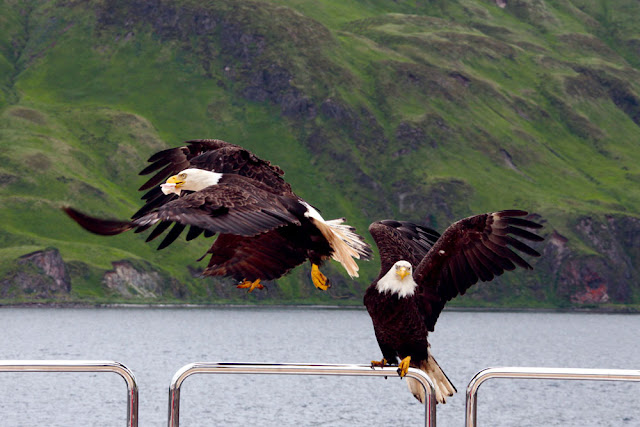
The magnificent bald eagle is the national bird of America, but most Americans are lucky to see one first-hand during their lifetimes. The Unalaska town offers classic examples of the striking nature you'll find throughout Alaska, but seems otherwise unremarkable. Then there's the unnatural amount of eagles here is due to Unalaska simply being a great place for the birds to score food. Unalaska is located on Unalaska Island and neighboring Amaknak Island in the Aleutian Islands off mainland Alaska. The small town of Unalaska, bald eagles are as common as pigeons are in other human settlements. The Unalaska is home of about 5,000 inhabitants, normally spare the space for bald eagles, who lurk above telephone poles, and stop lights watching for potential victims to sweep down upon, litter through trash, and steal grocery bags.

The view looks like out of a fairytale. Bald Eagles naturally built their nest up in trees, but Unalaska doesn’t have too many trees. So, Bald eagles find the other way to build their nests on cliffs, on the edge of town, and in manmade structures. The seven-foot wingspans, flesh-ripping beaks and vice-like talons, eagles rule the island. But why are there annual eagle attacks in Unalaska when raptors and humans peacefully coexist elsewhere in the state?

Therefore, it’s so easy to get a closer look of an eagle nest without even knowing it. The bald eagles get attacked anytime, which is why local law enforcement puts up warning signs all over the nesting season. The nesting season for America’s national bird runs from early June to the end of the summer. When going near their nests, they may be get angry and dislike it. So, local people constantly have a keep an eye out of the birds. There are almost ten cases every year, when people required medical attention after encounters with eagles with lacerated wounds. 

Moreover, fish is the favorite food of bald eagles, so during fishing season myriad eagles comes to scavenge and nest in the fishing town, creating lot of irritation to locals.  When fresh fish isn’t available, the birds will anything with meat, seagulls, ducks, squirrels, mice, the occasional raven, and human leftovers. Despite of all aspects, Unalaska is an excellent place to watch where you can take marvelous photographs. The bald eagles are called Dutch Harbor pigeons by locals. The bald eagles swarm every boat that comes into port, festooning the rigging by the dozen like baleful New Year ornaments.

Source: Charismatic Planet