Showing posts with label USA. Show all posts

Wednesday 23 May 2018

Graffiti Mesa, Valley of Names, California

During World War II, soldiers training in the desert north of Yuma, Arizona, started decorating a site they called “Graffiti Mesa,” using rocks to write out their names in the white sand. They expressed their feelings by placing stones on a piece of deserted land. They hoped that, even if they may never return home, their loved ones would get to see their message. The different sizes and shapes of rocks have taken many years to take in 10,000 names embedded in the desert floor maintained by the BLM (Bureau of Land Management). The Valley of the Names is covered in beautiful white sand, which creates a strong contrast against the dark-colored rocks. Due to the fact, that the land is barren for miles, each person must bring their rocks from the outlying desert.
The tradition treasure continued on after the war and the graffitied area bigger and bigger. Nowadays over 1,200 acres of land are decorated with signatures, messages, dates, initials, and drawings. The mesa, commonly known as the “Valley of the Names,” located in Winterhaven, Calfornia. It is made up of hard-packed white sand, and the earliest names are arranged using black lava rocks that stand in sharp contrast. It is well preserved land filled area, where you can express your feelings by placing stones on a piece of deserted land. The land is barren for miles around, which means the rocks must be brought in from the outlying desert.
Some people have cheated by bringing bricks and spray-painted rocks from home. If you have a message or name then you require a 4-wheel drive vehicle to access the area. Once there, it’s likely to drive down, around, and through the hills and valleys covered by this exclusive rock art. Hence, you have to bring your own rocks; there are plenty of black rocks on the road leading in. People still leave their distinctive note to loved ones nowadays.
This unique desert has scheduled a clean-up day, when people go out there to clear away debris from the desert winds and replace rocks that might have been washed away in a storm. People are coming here on trips in Trackers, Jeeps or Rangers to fresh their memories which they have written even 20 years ago. Today they use the technology of GPS and record the coordinates so they can remember where it’s at, even find their name without that. Source: CP


Wednesday 2 May 2018

Unalaska, The Town of Violent Bald Eagles


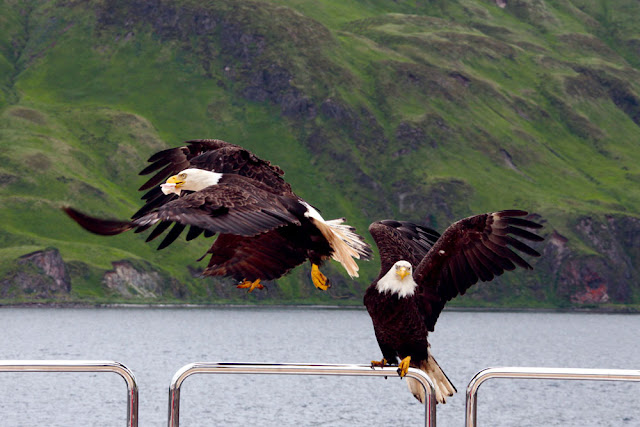
The magnificent bald eagle is the national bird of America, but most Americans are lucky to see one first-hand during their lifetimes. The Unalaska town offers classic examples of the striking nature you'll find throughout Alaska, but seems otherwise unremarkable. Then there's the unnatural amount of eagles here is due to Unalaska simply being a great place for the birds to score food. Unalaska is located on Unalaska Island and neighboring Amaknak Island in the Aleutian Islands off mainland Alaska. The small town of Unalaska, bald eagles are as common as pigeons are in other human settlements. The Unalaska is home of about 5,000 inhabitants, normally spare the space for bald eagles, who lurk above telephone poles, and stop lights watching for potential victims to sweep down upon, litter through trash, and steal grocery bags.

The view looks like out of a fairytale. Bald Eagles naturally built their nest up in trees, but Unalaska doesn’t have too many trees. So, Bald eagles find the other way to build their nests on cliffs, on the edge of town, and in manmade structures. The seven-foot wingspans, flesh-ripping beaks and vice-like talons, eagles rule the island. But why are there annual eagle attacks in Unalaska when raptors and humans peacefully coexist elsewhere in the state?

Therefore, it’s so easy to get a closer look of an eagle nest without even knowing it. The bald eagles get attacked anytime, which is why local law enforcement puts up warning signs all over the nesting season. The nesting season for America’s national bird runs from early June to the end of the summer. When going near their nests, they may be get angry and dislike it. So, local people constantly have a keep an eye out of the birds. There are almost ten cases every year, when people required medical attention after encounters with eagles with lacerated wounds. 

Moreover, fish is the favorite food of bald eagles, so during fishing season myriad eagles comes to scavenge and nest in the fishing town, creating lot of irritation to locals.  When fresh fish isn’t available, the birds will anything with meat, seagulls, ducks, squirrels, mice, the occasional raven, and human leftovers. Despite of all aspects, Unalaska is an excellent place to watch where you can take marvelous photographs. The bald eagles are called Dutch Harbor pigeons by locals. The bald eagles swarm every boat that comes into port, festooning the rigging by the dozen like baleful New Year ornaments.

Source: Charismatic Planet


Tuesday 20 March 2018

The Unique Fairy Stones of Harricana River


The fairy stones of Harrican river have seen in the past that concretions the precipitation of minerals around particles generally take spherical or oval shapes, as in the case of Klerksdorp Spheres and Moeraki boulders. Because pearl is another good example of concretions, can also take rare shapes. They are made of fine sand and clay, solidified by nature.  The originality and the forms of these stones are a phenomenon unique to Northern Quebec, particularly on the bottom of the big Lakes with a glacier origin.

In the Harricana River valley in the Abitibi-Témiscamingue administrative region of Quebec, Canada, concretions occur as flat discs, smooth on one side and puffed up on the other with stunning patterns. They were shaped over thousands of years by deposition of calcium carbonate over trifling pebbles and fossils. This is called “Fairy Stones” since hundreds of years, and used to carry them as fortunate charms when they went on fishing or hunting expeditions. The irregular lines on the stones are caused by the traces left by miniature worms or organic remains which were fossilized thousands of years ago.

It is believed that wearing a Fairy Stone would protect them against bad spirits and bring them good prosperity and health. However, geologists believe that Fairy Stones may have formed under a glacier, which recoiled thousands of years ago. Then they were carried by the water and deposited along the shores of certain lakes and rivers. Hence, one of the main rivers where Fairy Stones are found is the Harricana River, the second longest river in Canada. The name "Harricana" came from the Algonquin word Nanikana, which means “the river of biscuits” Biscuit refers to the unusual flat stones, sand, limestone and clay concretions, which are found in the river, called Pierres de fée or "fairy stones. A less romanticized version says Nanikana means "the main way".

These stones are frequently found in soft deposits under clay. The rounded, puffed up shapes come from the growing face that is face down in the clay, whereas the tops are weathered even by the retreating glacier and water. These are lying in the mud, they look like normal flat stones, but turn them over and you will amazed to see many different shapes and formation, as each Fairy stone is unique. These stones have been valued for a long time by the native community that lives around these stones birthplace. These stones have a strong link to the nurturing energies of the earth mother.  It can help teach you to care and have concern for the planet and all those upon it.


Wednesday 14 March 2018

Ubehebe Crater, Death Valley


In the Death Valley, you can find a large volcanic crater “Uhehebe” located at the north trip of Cottonwood Mountain. It is one of the many unique geologic features of Death Valley, which is believed, somewhere 2000 to 7000 years old. The Uhehebe Crater is one kilometer wide and 777 feet deep. Ubehebe Crater is a maars volcano. The formation was made when magma migrated close to the surface and heat caused groundwater to flash into steam, tossing massive quantities of pulverized old rock and fresh magma across the stony alluvial fan draped across the valley. However, the western cluster of Maar volcanoes was the first to form, then the southern cluster, followed by Ubehebe the largest of them all possibly 300 years ago. During the eruption, volcanic material in the form of ash and cinders was thrown out six miles from the craters.

The Ubehebe Crater is known as "Tem-pin-tta- Wo’sah", meaning Coyote’s Basket.  Furthermore, the colorful layers in the crater’s eastern wall are “fanglomerates” is an alluvial fan deposit hardened into rock. Sandstone and conglomerate, loosely cemented together by calcite make up this conglomerate and most of the pieces of rock are either volcanic or metamorphic. Hence, water erosion created the deep gullies that you see on the crater’s east side. The pink and brown mud flat at the bottom of the crater is the site of many short-lived lakes. At least a dozen craters are located within an area of 3 sq km, and bedded pyroclastic-surge deposits cover an area of 15 sq km. In this area volcanic soil is rich in nutrients and wildflower like Bigelow Monkeyflower absorbs heat, tend to bloom very early here, even in the late winter months, you might see some spring flowers early.

Moreover, winds at the rim of “Ubehebe” are very powerful and often gust above 50 mph, thus it is an easy walk and you can relish the stunning landscapes. Three major trails leads you to crater, one is start from parking area to bottom of Ubehebe, second is circumnavigates the crater rims, and third trail is leads off to little Hebe. Hence, the past 7,000 years, erosion has been creating deep crevices and fascinating patterns on the inner crater walls and they are at their most dramatic when the sun is low in the sky.  It is highly recommended to view the crater is when the sun is low in the sky in the morning or late afternoon. This amazing crater is impossible to describe in a way that does it justice. The depth and breadth is staggering, as the colors varied and beautiful. When you visit Ubehebe crater please be sure, you must stay on the trail since the crater rim and adjacent gullies are composed of very fragile material making them unstable and dangerous.


Thursday 8 March 2018

Badwater Basin, The Lowest Point in North America


In the Death Valley, there is an endorheic basin called Badwater Basin, the lowest point in North American with a depth of 282feet below sea level. The Badwater basin comprises of small spring-fed pool next to the road in a sink, accumulated salts of the surrounding basin make it undrinkable, thus giving it the name. The pool site itself does have animal and plant life, including pickleweed, aquatic insects, and the Badwater snail. The area which close to Badwater basin, where water is not always present at the surface, repeated freeze-thaw and evaporation cycles slowly push the thin salt crust into hexagonal honeycomb shapes. This is a popular site for tourists are the sign marking "sea level" on the cliff above the Badwater Basin. Badwater never dries out totally, and even manages to support a unique species of fish - the Death Valley pupfish, a small bluish creature which has evolved to survive in the hot saline conditions.  The salt pools, several routes towards the mouth of the valley, before sinking into the sand.

Moreover, the pool is not the lowest point of the basin; it is actually several miles to the west and varies in position subject to rainfall and evaporation patterns. The salt flats are hazardous to traverse to the sign marking the low point is at the pool instead. The area has extreme temperatures most of the year, but humidity from evaporation of salty water makes all movements more difficult than usual. The shade temperature crosses above 120°F, stands for a while really unforgettable in stifling heat. Be careful when you are walking as some of it can be brittle and break. As soon as you get the large concentration of salt, you can start to see the individual crystals that form with the life cycle of rain and evaporation.

At Badwater Basin, significant rainstorms flood the valley bottom periodically, well covering the salt pan with a thin sheet of standing water. This is the greatest evaporation potential in the United States, meaning that a 12 feet lake could dry up in a single year. When the basin is flooded, some of the salt is dissolved; it is redeposited as clean crystals when the water evaporates. Further low points aren’t usually popular tourist sites, but when you get to claim to be the lowest point in in the United States, it doesn’t matter if you are depressed or just a geography nut, it’s a site to see. So, no trip to Death Valley would be complete without a stop at the lowest point of Badwater Basin, right in the heart of the Death Valley National Park. Source: Charismatic Planet


Wednesday 21 February 2018

The Ancient Bristlecone Pines of the Great Basin


At high elevations in a region of the western United States recognized as the Great Basin. Here is a species of pine lives a quiet, isolated, and exceptionally long life. Bristlecone pines are famous for attaining great ages, have been found that have lived more than 5,000 years longer than any other non-clonal organism. Bristlecone pines are small to medium-sized windblown trees ranging from about 5 to 16 meters (15 to 50 feet) in height Bristlecone pines grow in isolated groves just below the tree line; grow in soils that are shallow lithosols, usually derived from dolomite and sometimes limestone, and sporadically sandstone or quartzite soils. Dolomite soils are alkaline, high in calcium and magnesium, and low in phosphorus.

The trees are extremely hardy, surviving in harsh freezing cold temperatures, being buried in snow, and restorative powerful winds. However, in several cases, portions of the tree can die-off and allow the tree to preserve its limited resources. Hence, Bristlecones aren’t very tall and every so often appear dead or very weathered. Few other plants can grow in the hard rock that Bristlecones prefer, and often the oldest trees are those that live in the most exposed and precarious places. Further, the Rocky Mountain population is sternly threatened by an introduced fungal disease recognized as white pine blister rust, and by pine beetles. The bark of the Great Basin bristlecone pine is characteristically orange-yellow to light brown, whereas that of the Rocky Mountain bristlecone pine is typically gray-brown. The female cones are ovoid in shape and deep purple when young; they mature to a pale brown and bear a characteristic bristle on each scale.

Although, one thing they can’t last is chainsaws. In what is now the Great Basin National Park of eastern Nevada, a tree known as “Prometheus” was being studied by a group of ecologists. Experts drill cores out of trees in order to count and measure the rings that chronicle their growth. Thus, much about the tree’s life and the ecological conditions in the area can be derived from these samples. Unluckily, when Prometheus was drilled for a core, the tool used for this process broke off inside. The investigator needed his tool back and to get it, he had to cut the tree down. Once he’d retrieved his tool and the core from Prometheus, he was able to define that the tree had lived 4,862 years longer than any other single living organism.

Moreover, an older tree hasn’t been found since, though one recognized as Methuselah is believed to be about 4,850 years old and its specific location is also being kept secret. Most of the living groves of these trees are under better protection now and can be visited in numerous locations throughout the Great Basin and in California. The other two species, Pinus balfouriana and Pinus aristata are also long-lived; specimens of both have been measured or estimated to be up to 3,000 years old. The study of the wood of these ancient trees has revealed environmental conditions stretching back to almost 9,000 years ago.