Showing posts with label Ireland. Show all posts

Saturday 12 July 2014

Loughareema Lake Ireland


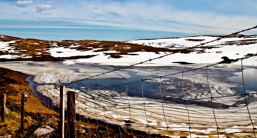
Loughareema is a distinctive lake in Northern Ireland located on the coast road, just a few miles from the seaside town of Ballycastle, the lake is vanishes from time to time. The water does disappear and reappear within hours. For this reason, the lake is known as the Vanishing Lake. The lake sits on a leaky chalk-bed with a sinkhole that often gets blocked up when peat washes into it. During the rainy season, water from surrounding land fills up the Loughareema depression. As a result, the depression turns out to be a lake. Though, the lake vanishes once the blockage is cleared. The lake drains quickly underground and a passerby who is not aware of the lake and its disappearing act would never even know it existed in the first place. The Loughareema Lake can vanish within just few hours of time. This phenomenon has made the Vanishing Lake one of the unique lakes in the world.

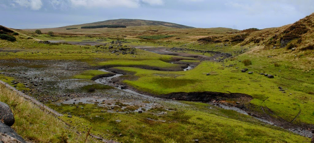
Interestingly, the road to Ballycastle runs right through the lake, though the modern road sits high enough to avoid flooding. It may be possible that the road engineers who constructed the road were misled by the lake’s trickery. In earlier days the route was often under water, occasionally for weeks on end, making crossing precarious. It was during one particularly bad state of flooding in 1898, a certain Colonel John Magee McNeille, apprehensive to catch the 3 pm train from the town, convinced his coachman to drive a covered wagon pulled by two horses through the lake. 

When they reached the middle of the lake, the cold water reached the bellies of the horse that became nervous. The coachman used the whip; the horse went rearing up on its back legs and turned to the side. The Colonel, his coachmen and the two horses soon succumbed to the perfidious, cold waters. Since then fateful day several people have reported seeing a phantom carriage pulled by two horses and ridden by a military man on the lonely shores of Loughareema. The road has been raised about the maximum flood level and just in case, a stone wall has been created on each side of the road as it approaches the Lough so that no-one can ever meets the same watery end as Colonel McNeille did on the afternoon of 30 September 1898.

 Source: Charismatic Planet


Sunday 22 June 2014

The Cliffs of Moher Ireland


The Cliffs of Moher or Aillte an Mhothair are situated at the southwestern edge of the Burren region in County Clare, Ireland.  The Cliffs of Moher are Ireland’s top visited natural attraction with a magical vista that captures the hearts of up to one million visitors every year. The cliffs receive their name from an old fort called Moher that once stood on Hag's Head, the southernmost point of the cliffs. They rise 390 ft above the Atlantic Ocean at Hag's Head, and reach their maximum height of 702 feet just north of O'Brien's Tower, 8 KM to the north. The tower is a round stone tower near the midpoint of the cliffs built in 1835 by Sir Cornelius O'Brien. On a clear day one can see from cliffs atop the tower, the Aran Islands in Galway Bay, the Maumturks and Twelve Pins mountain ranges to the north in County Galway, Maum Turk mountains in Connemara and Loop Head to the south, and the Dingle Peninsula and Blasket Islands in Kerry. O’Brien’s Tower stands near the highest point and has served as a viewing point for visitors for hundreds of years.

The North platform is situated at the highest point of the Cliffs, Knockardakin at 700 feet above sea level, which is the location of the Tower viewpoint, O’Brien’s Tower, built by Cornelius O’Brien. From this point you can view the An Branán Mór Sea Stack, home of the guillemots and razorbills. Therefore; you can also view the surfing wave ‘Aileen’s’, Aill Na Searrach, to the right when it is up and running. On a sunny day you can view across to the Aran Islands: Inis Oírr, Inis Méain and Inis Mór and to the left views of the stunning Galway Bay. Moreover; from this platform you’ve a terrific view of the South Cliffs that stretch for 8km. You can walk to Doolin, about five kilometers, from this point along the Coastal Walk.

Furthermore The South Platform is a perfect viewpoint of the Puffin colony; the puffins make their home on Goat Island, a grassy island when you see down and to the right. You can also see countless other seabirds and also have tremendous views of the sea stack below O’Briens Tower. From this point you can see the Cliffs as they continue on towards Hags Head. You may continue your walk to Hags Head it is roughly four kilometers each way with magnificent views of the Cliffs. The first floor of the Visitors Centre houses the Cliffs View Cafe, providing marvelous views of the Cliffs from the windows looking out of the hillside.

The cliffs are one of the most widespread tourist destinations in Ireland and topped the list of attractions and they’ve formed a part of the Burren and Cliffs of Moher Geopark, one of a family of geotourism destinations throughout Europe which are members of the European Geo-parks Network visitor center. Clare County Council started development plans in 1990 to enable tourists to get the experience of cliffs without substantial intrusive man-made amenities. The Cliffs of Moher visitor experience was built into a hillside approaching the cliffs. The center is intended to be environmentally sensitive in its use of renewable energy systems including geothermal heating and cooling, solar panels, and grey water recycling. The Cliffs of Moher visitor experience won an award in the "Interpret Britain & Ireland Awards" 2007 awarded by the Association of Heritage Interpretation. Though the award was precisely for the Atlantic Edge exhibition, the AHI assessed the whole visitor center and site. The citation stated that the entire visitor center was "one of the best facilities that the judges had ever seen."

The cliffs comprises mainly of beds of Namurian shale and sandstone, with the oldest rocks being found at the bottom of the cliffs. It is likely to view 300 million year-old river channels cutting through, forming unconformities at the base of the cliffs. There’re an estimated 30,000 birds living on the cliffs, representing more than 20 species. These include Atlantic Puffins, which live in large colonies at isolated parts of the cliffs and on the small Goat Island. Also present are gulls, guillemots, hawks, shags, ravens and choughs.

Saturday 17 May 2014

Ben Mount Benbulbin Ireland


Ben Mount Benbulbin is located in County Sligo, in the extreme north-west of Ireland, 10 KM north of the town of Sligo. The mountain Benbulbin is 527 meters and an entire county of Sligo and its symbols. Benbulbin is a protected site, designated as a County Geological Site by Sligo County Council. According to Irish legend, lived on this mountain monstrous boar of Benbulbin, Diarmuid was killed and buried in a hill Lech MUIKAM, near Dramkliffa at the foot of Benbulbin, according to his will, buried the great Irish poet WB Yeats. Its present form the mountain was during the last glacial period. Initially, it had a high “hump” that was cut creeping glacier.
Benbulbin almost entirely composed of limestone rocks. The name Benbulbin is also echoed in the name of the king Conall Gulban, a son of Niall of the Nine Hostages who was associated with the mountain; though, whether he was named after the mountain or the mountain after him is not clear. Benbulbin was shaped during the ice age, when Ireland was under glaciers, actually it was a large plateau and with the passage of time it converts into distinct formation. Benbulbin Mountain is composed of limestone on top of mudstones and these rocks formed approximately 320 million years ago in a shallow sea. Fossils exist throughout the layers of the mountains. All layers have many fossilized sea shells. The shale layer also holds some corals.
Benbulbin is an established dangerous climbing destination because the side bears the brunt of the high winds and storms that come in from the Atlantic Ocean. However if you climb from south side of mountain which is considered easy side since that side slopes very gently. And when climbers reached the summit, they’re rewarded with a magnificent view over the coastal plain of north Co. Sligo and the Atlantic Ocean. Therefore; Benbulbin hosts a unique and rare variety of plants, including particular organisms found nowhere else in Ireland. Several are Arctic–alpine plants, which grows in cooler temperatures than is normal. Some plants were deposited when the glaciers created Benbulbin i.e wild hares and foxes inhabit Benbulbin. In 2012, some researchers exposed that the Fringed Sandwort had survived the Ice Age and is possibly 100,000 years old.