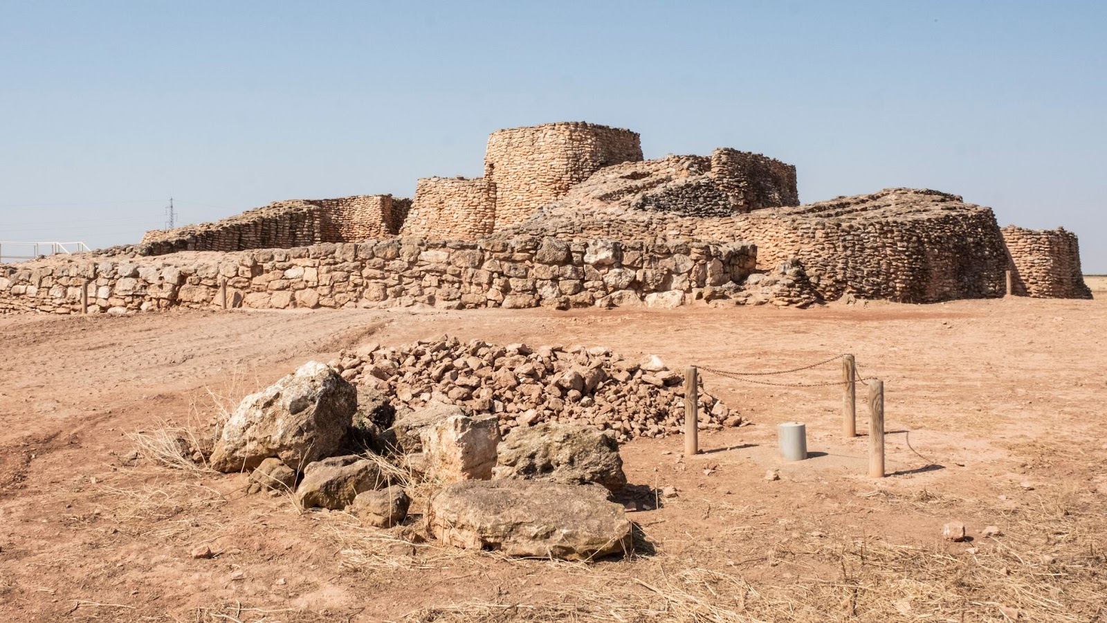
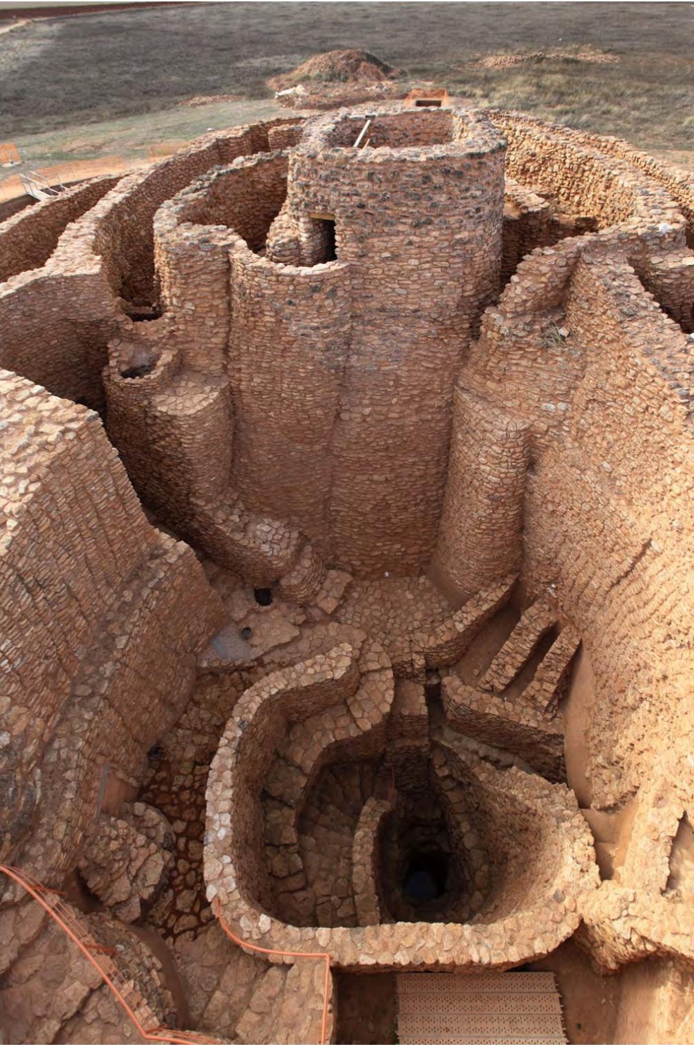
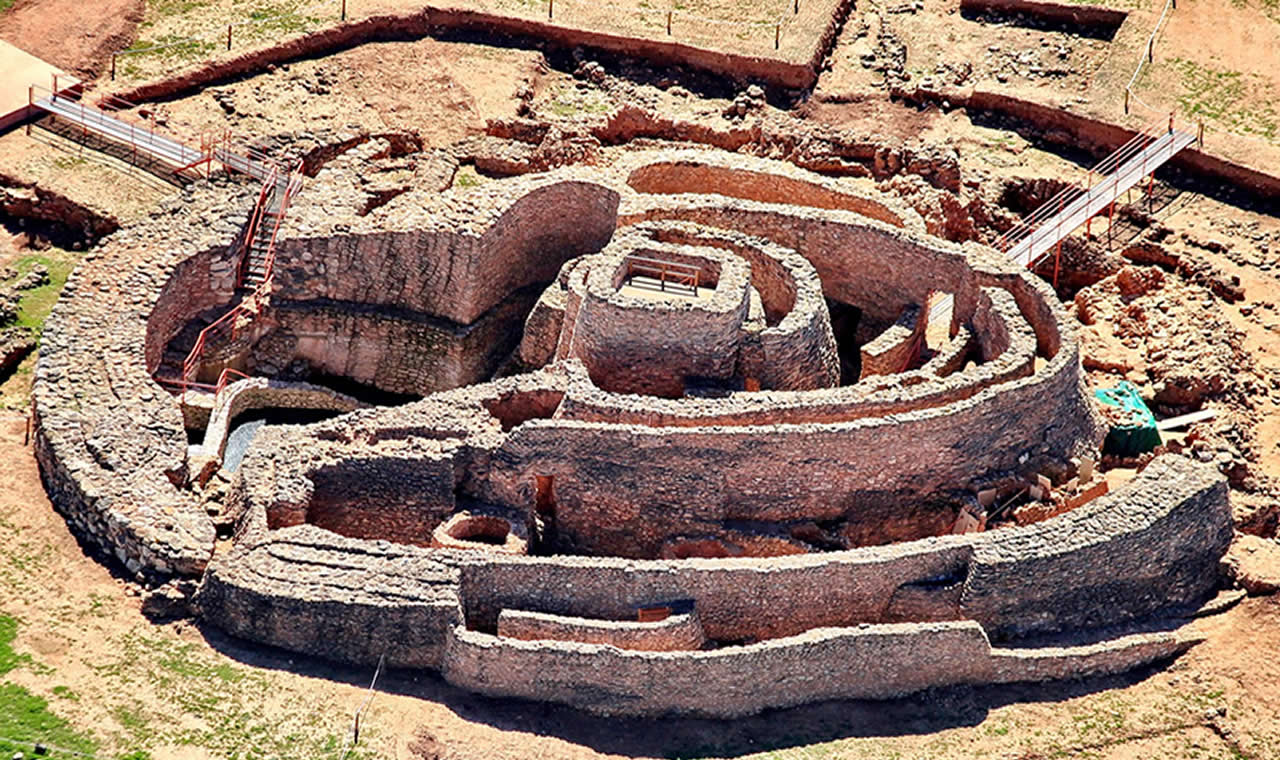
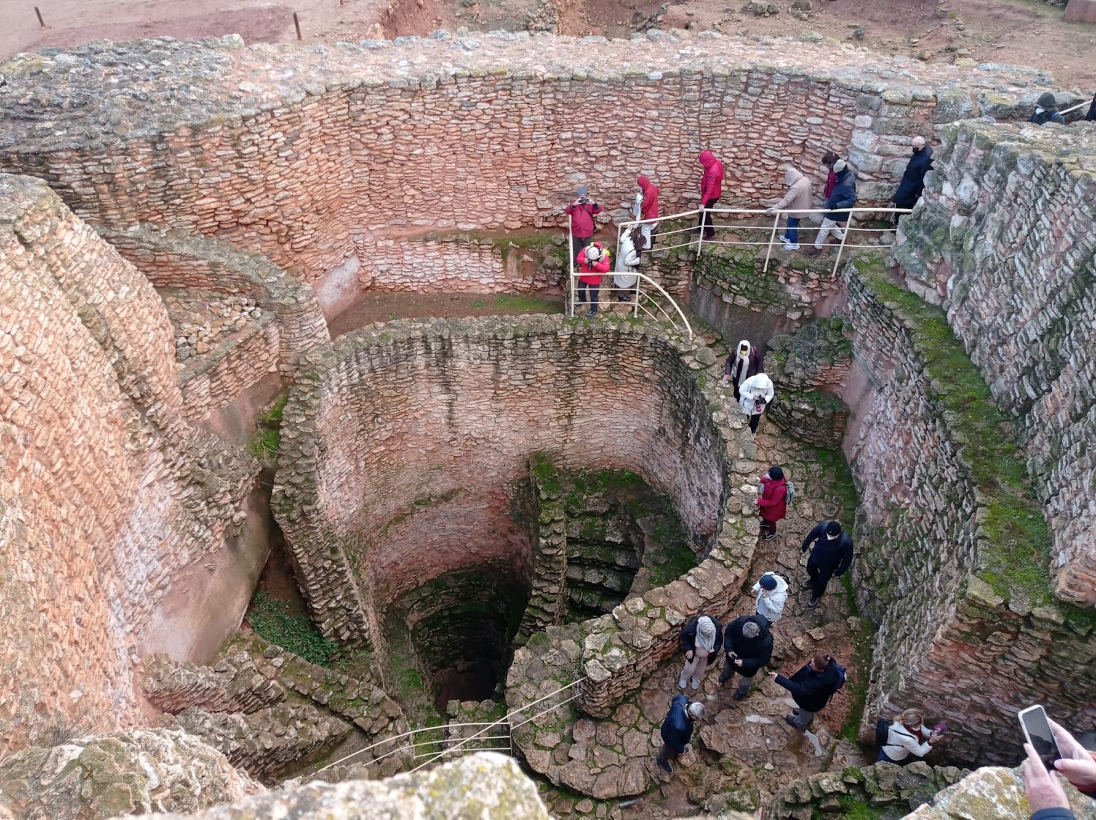
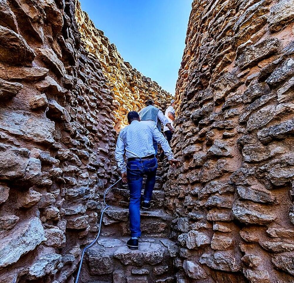
Showing posts with label Spain. Show all posts

Friday 3 February 2023

Cumbre Vieja volcano on the Spanish island of La Palma

 Cumbre Vieja is a volcanic ridge on the Spanish island of La Palma in the Canary Islands. It is considered one of the most active volcanic systems in the world and has a history of explosive eruptions and lava flows.

The most recent significant eruption of Cumbre Vieja occurred in 1949, and since then the volcano has been relatively quiet. However, scientists are closely monitoring the volcano due to concerns about a potential future eruption, which could have significant impacts on the island and surrounding areas.

One of the main concerns about Cumbre Vieja is the possibility of a massive landslide, known as a flank collapse. The flank of the volcano is believed to be unstable, and if a collapse were to occur, it could result in a massive tsunami that could affect the coastlines of neighboring islands and even distant coastlines.

Despite these concerns, the island of La Palma is a popular tourist destination and visitors are able to hike and explore the area around the Cumbre Vieja volcano. There are several trails that lead to the summit, offering stunning views of the surrounding landscapes and the ocean.

In conclusion, Cumbre Vieja is an active and potentially dangerous volcano, but also an important natural wonder and tourist destination on the island of La Palma. Visitors are encouraged to follow safety guidelines and be aware of potential hazards when exploring the area around the volcano.


Sunday 9 December 2018

Lanzarote Vineyards – The Magical Black Gardens

In Lanzarote, Spain there is a unique cultural landscape called “La Geria”. The La Geria covers around 5,250 hectares, of which almost 3,000 acres are cultivated. The vineyards of Lanzarote are spectacular and fascinating. Semi-Circular stonewalls protect verdant vines from the persistent blowing trade winds. In the first look, you can’t even help. The cultivation of grapes in Lanzarote is unique to this part of the world. But to be impressed by endless land that’s covered black ash and volcanoes. Most of the island has treeless, moonlike landscapes with different colored soils, craters, strange rock formations, and gently sloping mountains.
  
These vines spot actually created more than 250 years ago with human hands. Each vine yields produced approximately 25KG of grapes a year. However, rains make the place seem like a miracle. The greenery you might expect to find at this tropical latitude is almost completely absent from most of Lanzarote. The young vine is placed into this human-made depression. Then, larger volcanic stones are balanced around the wind-facing edge of the hole, creating a low, semicircular barrier.

The ‘Paisaje Protegido’ – cultural protected landscape has an interesting history. In the 18th century, Lanzarote was a lush island with a thriving agriculture industry.  But massive volcanic eruptions took place in the 1730s when the entire region was covered in Lave ash. A series of violent eruptions left thick layers of ash and volcanic pebbles on the ground. That is also called lapilli, Rofe or picón. Therefore, thousands of hectares of fertile farmland were lost under up to three meters thick layers of ash. After the volcanoes had ceased to rumble, the Islanders starts to dig holes until they came upon fertile soil in areas where the lapilli was thin.

Then they began to plant vines and other fruit trees. After they quickly realized that the ash was a blessing in disguise. The lapilli is porous and has hygroscopic (water-attracting) properties. Some wineries still follow the traditional practice of using camels to haul newly harvested grapes from the vineyard to the processing areas, which are lower on the hillside.

The cool breezes from the Atlantic and the warm temperatures from the African mainland give the vineyards the kind of warm-to-cool variation that grapes need. Also, the days are warm and almost always sunny; nights are very cool.  Though annual rains fall is very low in Lanzarote. But early morning hours are very humid and allow ash to store the morning dew. The difference in temperature, known in the viticulture world as the diurnal temperature variation, is important for grapes to develop both the right amount of acidity and sweetness.


The pits were the vines are dug have to be 5 meters in diameter and 2-3 meters deep and also need a lot of space. The roots spread out in a wide circle near the surface to be able to absorb as much water as possible. The range of wines from La Geria includes the traditional Lanzarote wines Malvasia, Listán Negra, Moscatel, and Manto. To add to the mystic, tourists often arrive at the wineries' bodegas on the backs of camels. Imported from the Sahara long ago, these beasts are able to easily negotiate the soft, sandy soil and go where vehicles cannot. Lanzarote landscapes are unforgettable and you must visit once in a lifetime.
 Source: CP


Wednesday 14 November 2018

The Ancient Walls of Avila


The ancient city of Avila is located in central Spain, in the autonomous community of Castile and León, about 100 km to the west of Madrid. This walls is considered as one of the finest walled city in Europe. The Walls of Avila is built on the flat summit of a rocky outcrop which rises abruptly in the middle of a vast treeless plain strewn with immense grey boulders and surrounded by lofty mountains. The Walls of Avila is about 2,500-meter long and almost completely intact. The Old Town of Avila was declared a UNESCO World Heritage Site in 1985. The walls construction work was started in 1090 but most of the defensive walls appear to have been rebuilt in the 12th century.  

The Walls of Avila has an average width of 3 meters and an average height of 12 meters.  The city Avila was once part of the Roman Lusitania, before falling to the Arab and Berber invaders in 714 CE. For the next 350 years, the northern Iberian Christian kingdoms tried repeatedly to seize control of the city. However, it was King Alfonso VI of León and Castile, who eventually managed to conquer the Muslims in 1088 ADE. The King instantly started building great stone walls around Avila to protect his latest conquest from further attacks. The job was supervised by his brother-in-law, Raymond of Burgundy, who was a legendary figure himself.

The Walls of Avila is an impressive 2.5 kilometers barrier of stone and granite that surrounds the city’s almost rectangular layout. This wall is up to 10 feet thick and 40 feet high, and topped by a continuous battlement rampart-walk and parapet with merlons and cernels. Protruding out from the Walls are 88 semi-circular defensive towers, placed at uniform intervals.

The Walls of Avila are punctured by 8 or 9 entrance gates. Originally, there was a moat and a barbican outside the walls but they no longer exist. The huge fortification was completed in less than a decade. The area enclosed by the walls is now designated the Old Town. It contains all of the city’s historic landmarks including the Gothic cathedral. The Convent of Santo Tomás, containing the tombs of Tomás de Torquemada, who was the first grand inquisitor of Spain, and of Don Juan, the only son of Ferdinand and Isabella, and several Romanesque churches.

Nowadays it is possible to walk upon the walls for approximately half their circumference. At night the entire circumference of the walls is beautifully lit up by yellow-orange halogen lights. Which are making it the largest fully illuminated monument in the world?


Friday 18 August 2017

Playa de Gulpiyuri – A Strange Beach in the Middle of a Meadow


Playa de Gulpiyuri is a strange beach as we know it, has 50m of sand but it’s actually in the middle of a field, around 100m from the sea. A tunnel beneath the rocks channels water from the Cantabrian Sea into a cove, beach is off the A8 road between Santander and Oviedo. Gulpiyuri Beach is nothing like anything you’d have ever seen, or even imagined existed outside of imaginary books or fictional planets. Playa de Gulpiyuri is one of the most astonishing beaches in the world, tucked away into a small inland hollow. The other famous hot water beach of New Zealand or California’s glass beach, but none like the beach of Gulpiyuri. The beach is over 100 meters away from the sea shoreline and stumbling over a small appealing beach right in the middle of a green meadow. And though you may find other beaches totally hidden from the open sea, around the world, this one is actually fully tidal and even has waves bathing the small strip of golden sand.
Though sometimes referred to as the “world’s smallest beach,” Playa de Gulpiyuri is one of the world’s strangest and picturesque. This tiny golden sand beach, with crystal clear waters and hemmed in by cliffs, is frequently voted as being Asturias' best. Moreover, the salt waters of the Cantabrian Sea bored through the earth, forming a series of underground tunnels that constantly feed water to Gulpiyuri Beach. Water from the nearby Bay of Biscay comes in through the underground tunnel network and washes up on Gulpiyuri in gentle waves, adding to the charm of this magical cove. Playa de Gulpiyuri in Llanes is now listed as a natural monument by the Principality of Asturias.
Therefore, the shallow crystal clear water of this place acts as a swimming invitation that cannot be refused, but you may find it a little cold, because the water tends to remain underground for a while, before washing into Gulpiyuri Beach. If you visiting this magical beach then make sure during the peak summer months, it can and does get busy. Because, hundreds of visitors a day flock here to take images. It has the uncertain reputation of being one of Spain's most photographed beaches. At high tide you can just about swim, although at most times, the water levels remain at knee height, shallow enough to ensure that the Atlantic chill has been taken off, but still fairly cold.


Monday 17 April 2017

El Caminito del Rey Path, The Most Dangerous Foothpath in Spain’s


The world’s most dangerous footpath is set to reopen for the tourist season on 22 April 2017. This is one of Spain’s most prevalent tourist attractions, El Caminito del Rey Path, slices through the Gaitanes Gorge providing thrill seekers with dramatic views 330ft above Gualdalhorce River. The reinforced King’s Little Pathway, as it is known in English, is now more of a beauty spot than a danger zone after a £4million restoration project. The dangerous walkway was revamped and re-opened in 2015 after 5 people plunged to their deaths between 1999 and 2000. The attraction was so popular among peoples, as path has welcomed more than 600,000 tourists before re-opening two years ago.  

The attraction is so popular that it has set a limit of visitors per year at 300,000, with 1,100 admitted per day. The four-mile network of paths will open from Tuesday to Friday, depends upon weather conditions, and it is estimated that it will take the average visitors 4 to 5 hours to walk the full route. For the security point of view, it was restored and security fences were installed, El Caminito del Rey was a dangerous climbing spot, enticing daredevil holidaymakers from around the world thanks to its state of disrepair. The narrow concrete path, supported by steel stanchions at around 45 degrees into the rock face, had wide gaps and rickety hand rails that posed a massive challenge even for experienced climbers. However, accessible from the towns of Ardales and Alora (El Chorro), the footpath is a century old and was built for workers at two nearby hydroelectric plants. It is now managed in a joint venture by Hermandos Campano and Bobastro 2000.


Wednesday 29 June 2016

The Roque Cinchado: A Unique Rock Formation in Island of Tenerife


The Roque Cinchado is a rare rock formation lies within the Teide National Park in the municipality of La Orotava Canary Islands of Spain. Roque Cinchado is one of largest in the world by altitude, more than 2000 meters. The Roque Chinchado is a unique rock formation; in fact its photographs appeared on 1000 peseta bank notes with Teide in the background. Roque Chnchado is a marvouls geological freak show of twisted pinnacles of lava, formed as a result of erosion of the volcanic dykes. The Roque Cinchado worth to take a look and in this specific case, it is the most photographed rock in the world. Many archaeologists believe and considered this rock formation is equally important as the other rock formation of Uluru in Australia, Delicate Arch Utah USA, and Devils Tower Wyoming USA. The compositions of Roque Cinchado are mainly of pyroclastics, alluvial fan breccias, and conglomerates of volcanic material, phonolitic dikes crosscutting the sedimentary layers.

The Roque Cinchado is to be found about 1700 meters below the summit of Teide volcano, actually a volcanic formation; belongs to a lineup of large rock formations, leftovers of the former summit of the island, well-known as "Roques García." From every passing century, the rain and wind has gradually worn down the earth and rock formation to expose the harder rock of the dykes in all their glory. The Roque Chinchado rock is eroding faster its base then above, could be topple one day.  Important, somewhat puzzling and actually saddening is the fact the Island of Tenerife is one of massive volcanic edifice that is actually second in size after only the Island of Hawaii (Big Island). Nevertheless from the rocks, the lunar landscape of the “Llano de Ucanca” plains is just to the west of here a completely surreal landscape that just has to be seen to be believed.

Tuesday 26 April 2016

The Aqueduct of Segovia

The Aqueduct of Segovia is a marvelous Roman structure and one of the most noteworthy and best-preserved ancient monuments left on the Iberian Peninsula. More precisely you can call it Aqueduct Bridge, located in Spain, foremost symbol of Segovia, as evidenced by its presence on the city's coat of arms. In-fact it is city’s most vital architectural landmark had been kept functioning from several centuries and preserved in great condition. The Aqueduct construction date is not confirmed, however it is believed that it took place somewhere Ist century AD during the reigns of Emperors Domitian, Nerva and Trajan. 
The first reconstruction took place during the reign of King Ferdinand and Queen Isabella, when a total of 36 arches were built with great care without disturbing the original design. The unmortared brick like granite blocks used to construct aqueduct in Roman era. Moreover, the three tallest arches showing a sign in bronze letters, indicating the name of its builder. These days, two niches are still visible, one is Hercules and other is image of Virgen de la Fuencisla. The Aqueduct Bridge is built about 20.400 blocks of granite, 7.500 m3 of granite with a total weight of 20.000 tons. Hence the largest block in the bridge has a weight of 2 tons, and blocks of 1.000 kg are common.

The site was listed in the 2006 World Monuments Watch by the World Monuments Fund. Indeed the Aqueduct of Segovia is an exclusive structure, still carries its original character and remains a protuberant and evocative feature of the regional landscape.  It represents to aesthetics and functionality that are so strongly associated with the engineering prowess of the Roman Empire. The Aqueduct of Segovia functioned for many centuries after the fall of the Roman Empire and served the communities of Segovia well into the modern era. The aqueduct is special in every pillar and spandrel has a different design, have a common springer, others have separate but touching ones, and the base of several of the spandrels is different. There’re few arches in the center of aqueduct which were ruined during Muslims conquest of 9th century, however Catholic Kings had restored in the 15th century.

Well, the one of major purpose of building Aqueduct is to transport water from Rio Frio River 11 miles from the city in the La Acebeda region took 9.3 miles before arriving in the city. The water was first gathered in a tank and led through a channel to a second tower. The tallest aqueduct reaches a height of 28.5 meters, well supported by single and double arches to pillars. It provided water to Segovia until the mid-19th century. Nowadays it is well-deserving structure to pay attention in its continued protection and stabilization. The Aqueduct of Segovia remains one of the most intact Roman aqueducts in Europe.

The Aqueduct of Segovia structure stands 28.5 meters tall at its maximum height and nearly 6 additional meters deep in the main section. Along pillars and arches of its tall, two-story arcades are made of solid blocks of stone fit closely together with little or no mortar, and the lower arches alternate in height according to the structure’s adaptation to the contours of the land. This is not a religious site, but it is such a magnificent monument that we just can't bear to leave it out.  This is most visited and photographed sight in Segovia and the symbol of the city, its massive scale and state of preservation are unmatched anywhere in Europe. Unluckily, after surviving remarkably intact for nearly 2,000 years, the aqueduct is now being extremely threatened by the pollution and traffic vibrations of the modern world. Source: Charismatic Planet