Showing posts with label Colombia. Show all posts

Wednesday, 1 July 2020

The Stone of El Peñol

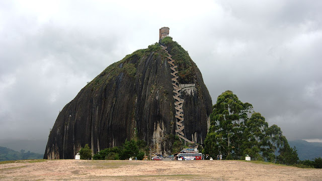
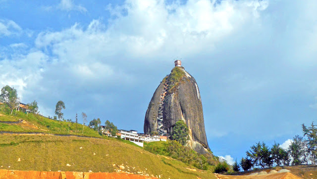
The Rock of Guatape, is an iconic landmark inselberg also famous as “The Stone of El Peñol” located in the border of two towns Guatapé, and El Peñol Antioquia in Colombia. Hence, both towns claimed ownership of the Rock Guatape. The Guatape Rock has also historically claimed the rock as their own and thus has led to various names for the site. The landform is a granitic rock remains that has resisted weathering and erosion, probably as result of being less fractured than the surrounding bedrock. The town of Guatape is a major tourist attraction, particularly for travelers from Medellín, for both El Peñón de Guatapé, and the famous zócalos that adorn numerous buildings.

The Guatapé is an outcrop of the Antioquia Batholith and towers up to 656 feet above its base. Tourists can scale the rock via a staircase built into one side, a path that includes more than 649 steps to the top. Number of food and markets stalls available near the base of the Rock. About halfway up the stairs, there is a shrine to the Virgin Mary. The summit contains a three-story viewpoint tower, a convenience store, and a seating area.

The indigenous South American agricultural tribe Tahamí, former inhabitants that region, superstitions and worshiped the rock and called it in their language mojarrá or mujará. In 1954, the rock was first climbed by three climbers Luis Villegas, Pedro Nel Ramirez, and Ramón Díaz in a five-day endeavor, using sticks were embedded in the fissure on the rock. Hence, the staircase was built later on to allow people to climb to the rock without needing particular equipment.

Pitcairnia heterophylla (A new species of plant) was found on the top of the rock. The beautiful viewing spot was built on top of the rock. Here, visitor can buy different handicrafts, souvenirs, postcards, and other local goods. It is possible to see the five hundred km shore-perimeter dam. There are 740 steps to the uppermost step atop the building at the summit, a fact reinforced by yellow numbers also seen in the climb up the stairs. In the 1940s, the Colombian government declared it a National Monument.

According to Wikipedia On the western face of the stone there are painted large white letters "G" and an incomplete "U" (only the single vertical stroke was completed, resembling an "I"). The towns of Guatapé and El Peñol had long disputed ownership of the rock, and the residents of Guatapé decided to settle the matter by painting the town's name on the rock in huge white letters. It did not take long for the residents of El Peñol to notice the work, and a huge mob was assembled to stop it. Only the "G" and part of the "U" were completed.

The rock rises from the bottom of the hydroelectric dam of Peñol-Guatapé. This monolith was spotted as a border landmark between country farms and the two cities of Guatapé, and El Peñol.  At its highest part, on the rear southeast side, it has an elevation of 7,005 ft above sea level, with an average temperature of 18 °C. The massive rock "Peñol" is 935 ft long and 360 ft wide. It has some rock breaks, one of which was used for the construction of 650 steps of the stairway that can be used to go to the top.

The Stone of Peñol is mix of minerals such as of quartz, feldspar and mica. The view from atop of this 70-million-year-old rock is unimaginable an enormous lake full of small islets. The rock is easily visible for miles from the surrounding countryside. There are very few travelers leave Medellin without making a visit to this pre-historic massive rock. Even today, researchers are uncertain how the rock was formed or where it has come from.


The Stone of El Peñol

The Stone of El Peñol

The Stone of El Peñol

The Stone of El Peñol

The Stone of El Peñol

The Stone of El Peñol

The Stone of El Peñol

The Stone of El Peñol

The Stone of El Peñol

The Stone of El Peñol

The Stone of El Peñol

The Stone of El Peñol

The Stone of El Peñol

The Stone of El Peñol

The Stone of El Peñol

Sunday, 24 March 2019

Tatacoa Desert - Colombia

Among all the landscapes in Colombia, Tatacoa Desert is most impressive, due to its greatness, its natural rarity, and its peculiarity.  A 330 Square Kilometers desert is a second largest arid zone in Colombia after the Guajira Peninsula. The desert is located north of Huila Department, 38 KM from City of Neiva and 15 KM from Natagaima in Tolima. This semiarid region is a rich deposit of fossils and has two distinctive colors, other in the area of Cuzco and gray in the Los Hoyos area. The Tatacoa Desert is one of the few places on the earth, where the sky always seems majestic. In the desert, you can expect blue skies during the day and endless constellations at night.

Tatacoa Desert Landscape

The Tatacoa Desert or the Valley of Sorrows is not just a desert, but a tropical dry forest. Tatacoa is a Spanish name, meaning rattlesnakes. During the Tertiary Period, it was much wetter, with thousands of rare flowers and trees, but as time passes, it has been gradually drying up to become a desert. The Tatacoa is heavily eroded and crossed by dry canyons that develop transiently in the winter months or during the rainy seasons.
The exclusive secretive shapes are created on clay surfaces, creating labyrinthine gullies in the landscape that can reach 20 meters deep. The Tatacoa Desert is one of the amazing landscapes, geographical wonders, and a magic sky. The desert average temperature is 28° C; yet on sunny days, it can go up to 40° C. For these reasons, the Tatacoa Desert receives many visits of paleontologists and geologists for whom it is a research paradise.

Fauna and Flora in Tatacoa Desert

In the low humidity and high temperatures, there is relatively little runoff, and animal and plant life is adapted to the conditions. The plants in this area are adapted to climatic conditions through the development of horizontal roots. The wildlife includes rodents, turtles, spider, snakes, spiders, scorpions, eagles, alligators and wildcats, and cacti reaching between four and five meters high.

Great Tourist Destination 
          
Tatacoa Desert atmospheric conditions are good for astronomy and many extraordinary natural destinations of Colombia. The area has little pollution or noise, attracting tourists who stay there to enjoy the silence, scenery and tranquility or the stressful city noises. Although it is not necessary to go into the observatory for stargazing, as the desert is a place with a privileged and clear view of the sky, as there is no light pollution.

The most important thing is your health in a desert environment. So bring plentiful water as you could get lost, get sunstroke or dehydrate. So, to make your experience safer it is the main key. Tatacoa Desert is one of the most iconic places in Colombia. Despite the particular geographical conditions, a cavernous desert, difficult climatic conditions has become one of the most popular tourist destinations in the country. A good reason to be here, The National Bambuco Pageant is the Tatacoa Star Party 2009, which will take place in the desert between June 17 and 20, 2009. Source: CP

Things to Do in Tatacoa Desert

Here are some of the interesting activities that may entice you whilst at Desierto de la Tatacoa.
·         Observatorium
·         Rent a Bike
·         Horse Riding
·         Fauna and Flora
·         Hiking with a local guide

·         Swimming


Thursday, 25 February 2016

The Puente de Occidente Colombia


The Puente de Occidente is also called Bridge of the West is located in western Antioquia, Colombia. The Puente de Occidente is a suspension bridge that connects the municipalities of Olaya and Santa Fe de Antioquia, east and west of the Cauca River, respectively. Therefore, this was an impressive single suspension span supported from four pyramidal towers on each bank of the river with each tower anchoring two cables. The suspension bridge has a main central section which cars and smaller trucks can cross and two pedestrian paths on either side of the central roadway. So far, it is considered the 7th largest suspension bridge worldwide. 

The bridge construction was started in 1887. So, material mainly iron and steel was being imported from England, however towers were built with local materials. The 291 meter high bridge works begin in December 1887 and completed in 1895, approximately five years after initiation with the final cost was 171.000 pesos. Initially it was open for pedestrian only, but later on decision was made revert and vehicles were allowed. These days much longer suspension bridge in providing facilitation to South American. Once, the Puente de Occidente was longest of such type in the continent, and with the passage of time, it requires repair work, which were significantly performed in the early part of 2014. In Nov 1978, it was declared a National Monument of Colombia. Moreover, the structural system of the Puente de Occidente is alike to the suspension/cable-stayed hybrid used in the Brooklyn Bridge. The bridge´s structure is made up of four caraway wooden towers, iron sheets supported on masonry walls, wire ropes and a roadway of 3.10 meters wide and lateral sidewalks. In 1955, bridge was underwent reinforcement works to increase the bearing capacity to allow vehicles. 

The Puente de Occidente was an expeditious way to get to the Magdalena Rive the country’s main waterway that divides the province into two parts. The major purpose was to construct the bridge actually remove the obstacles in order to establish the trade routes and would connect the region with other regions in the country. On May, 30 1881, a decision was made to build the suspension bridge over the Cauca River. Before the bridge, the river was undoubtedly, the greatest obstacle for the communication between the people of Antioquia. Due to rich history, and vulnerability, the bridge is included in tentative list of UNESCO World Heritage Site. 

Friday, 8 May 2015

Chan Chan: The World Largest Adobe City


Chan Chan city is located near the Pacific coast in the Peruvian region of La Libertad, approximately five kilometers west of Trujillo. It was the largest Pre-Columbian city in South America and the largest earthen architecture city in the world. Chan Chan was the capital of the Chimú civilization that stretched along the northern coast for a thousand kilometers from just south of Ecuador down to central Peru. The city itself was built about 850 CE and lasted until its conquest by the Inca Empire in 1470. At the height of the Chimú Empire, Chan Chan stretched more than 20 square km with a monumental zone of about 6 square kilometers in the center, and housed a projected 60,000 populations. Therefore, the city had 9 large rectangular citadels surrounded by thick earthen walls about 30 to 60 feet high. Moreover within these units, were thousands of buildings including temples, houses, stores are arranged around open spaces, together with reservoirs, and funeral platforms. 

The walls of the buildings were every so often decorated with raised carvings representing abstract motifs and animals. Outside these nine rectangular units were four industrial sectors fixed to woodwork, weaving, and the work of gold and silver. Unluckily, the city was deprived of these valuable metals by Spanish treasure hunters who ransacked the city during the 16th century. Moreover, an area further to the south was used for farming; the land watered by an intricate system of irrigation. Chan Chan was recognized in one of the world's bleakest coastal deserts, where the average annual rainfall was less than a tenth of an inch. It was due to dry desert air that allowed the city’s earthen structure to remains to this day. Ironically, due to the changes in weather conditions, nowadays Chan Chan is endangered by too much water, as heavy rains steadily wash away this ancient city.


Source: Amusing Planet

Sunday, 22 June 2014

The Greatest “Amazon River” is Home to Several Extremes


Amazon River is the greatest river of South America and the largest drainage system in the world in terms of the volume of its flow and the area of its basin. Amazon River is at approximately 4,000 miles (6,400 kilometers) equivalent of the distance from New York City to Rome. Amazon River is the 2nd longest river in the world, just slightly shorter than the River Nile, but the largest river by volume. The length of the Amazon and the Nile Rivers has been in a tight battle for title of world's longest river. The precise length of the two rivers differs over time and reputable sources disagree as to their actual length.

The Amazon River has more than 3,000 recognized species of fish and more new species are still being discovered. The Amazon Basin is covered by half of the planet’s remaining rainforests. Therefore a tenth of the world’s projected 10 million living species live in the Amazon rainforest, jungle tours are more about the boating upriver into the damp, buzzing, oppressive ambience than actually spotting animals. Amazon River westernmost source is high in the Andes Mountains, within 160 kilometers of the Pacific Ocean, and its mouth is in the Atlantic Ocean, on the northeastern coast of Brazil.

As most of know, that Amazon River is located in South America.  And it runs through Guyana, Ecuador, Venezuela, Bolivia, Brazil, Colombia and Peru. During the rainy season, the Amazon River can stretch to over 190 kilometers (120 miles) in width. There’re no bridges that cross the Amazon, because there is no need of bridges as the majority of the Amazon River runs through rainforests rather than roads or cities. The largest city along the Amazon River is Manaus. Located in Brazil it is home to over 1.7 million people. The one of world’s largest snake Anacondas lurk in the shallow waters of the Amazon Basin, they’re occasionally attack larger animals such as goats that get to close the water. The Amazon River is also home to the piranha, a meat eating type of fish! Being carnivores, piranhas are famous to attack in groups, preying on livestock that strays into the water and possibly appearing in one or two of your own nightmares!

The Amazon River is not only the greatest in the world but it is also home to several other "Extremes" A captured Arapaima: one of the largest freshwater fish species in the world of the natural world. Rapaima is locally famous as Pirarucu Arapaima gigas are one of largest, fresh water fish in the world. They’ve been found to reach a length of 15 ft/4m and can weigh up to 440lbs/200kg. Catfish normally found in warm & slow moving waters of lakes and streams are pretty creepy looking fish with big flat heads and "whiskers" on either side of their heads. Most catfish are anywhere from 8” in long to about 5 feet and weighing in at up to 60 pounds. But the catfish that lives in this part of world is as big as nature will allow they’ve been captured weighing over 200 pounds! One of the largest freshwater fish in the world is found living in the waters of the Amazon River.

Cool Factoid: Did you know that bull sharks have been found in the Amazon River? Researchers have captured live bull sharks as far as 2,300 miles inland from the sea thriving in freshwater in the foothills of the Peruvian Andes. Amazon River drainage basin is the whole northern half of the continent of South America as a shallow dish or saucer. Whenever rain falls and lands anywhere in the river basin it all runs into the lowest place in the pan, which happens to be the Amazon River. The sheer volume of rain in the Amazon jungle and the slope of the surrounding land, combine to create the enormous river famous as the Amazon.

 Here's list of some species which can easily found at Amazon River. 
Violet-Fronted Brilliant
Tupi ‘red bird,’ also known as the scarlet ibis
Toucan
Tillandsia cyanea
The water lily (Victoria regia
Tapir
Striated Heron
Squirrel Monkey
Red-Bellied Piranhas
Piranha
Pink River Dolphins
Payara (Vampire Fish)
Palm Tanager in the Amazon
Masked Crimson Tanager
Pacu
Lily of the Amazon
Laguna
Godzilla.
Ginger Torch
Emerald Boa
Giant Otter
Electric Eels
Capped Heron
Alligators
Amazon Flower
Amazon Lily
Anaconda
Black Caiman
Black-crowned Night-Heron
Bull Sharks
Candiru
Capped Heron